GLOBAL HUMAN SETTLEMENT ANALYSIS FOR DISASTER RISK REDUCTION
M. Pesaresia,∗D. Ehrlicha
, S. Ferria, A. Florczyka,S. Freirea,F. HaagaM. Halkiaa,A.M. Juleaa, T. Kempera, P. Soillea
aEuropean Commission, Joint Research Centre,
Istitute for Protection and Security of the Citizens, Global Security and Crisis Management Unit, Via E.Fermi 2749, I-21027 Ispra (VA) Italy
KEY WORDS:Global, Human Settlements, Urban areas, Urbanization monitoring, Remote Sensing Data Automatic Classification
ABSTRACT:
The Global Human Settlement Layer (GHSL) is supported by the European Commission, Joint Research Center (JRC) in the frame of his institutional research activities. Scope of GHSL is developing, testing and applying the technologies and analysis methods integrated in the JRC Global Human Settlement analysis platform for applications in support to global disaster risk reduction initiatives (DRR) and regional analysis in the frame of the European Cohesion policy. GHSL analysis platform uses geo-spatial data, primarily remotely sensed and population. GHSL also cooperates with the Group on Earth Observation on SB-04-Global Urban Observation and Information, and various international partners and World Bank and United Nations agencies. Some preliminary results integrating global human settlement information extracted from Landsat data records of the last 40 years and population data are presented.
1. INTRODUCTION
Global actors and global decision making processes need accu-rate and globally consistent data for evidence-driven reasoning: testing of hypothesis, development of concepts, monitoring and understanding of trends, and exploration of alternative scenarios. Space and airborne remote sensing technologies have contributed since the 60 of the last century to make consistent data series describing the physical characteristics of the global atmosphere, ocean and land masses. Census surveys techniques reporting about the amount of population, houses and productive activities have more than 5,000 years history dating back to the origin of the state and urban social organization of the humanity. The same can be affirmed about cadastral and geometrical land surveys tech-niques that have been an essential element in the development of the human environment since the beginning of recorded history. Taking apart hunter and gathering societies, today the absolute majority of human beings spend the dominant part of their life time in built artificial environment supporting by different means both their symbolic-cultural and practical-functional necessities. From the material and practical point of view, this artificial envi-ronment includes closed built-up structures and their open neigh-borhood spaces as roads, squares, gardens. The whole above can be shortly described as belonging to the basic, physical or mate-rial elements of the human settlement.
The understanding of the global human settlements is absolutely critical for a large number of issues including housing and ur-ban development, poverty reduction, sustainable development, climate change, crisis management and disaster risk reduction, just to name a few. But despite their importance and despite the long history of human development in the surveys techniques, apparently basic questions about global human settlements still remain unanswered, as for example: how many square/cubic me-ters we have built in the last 40 years?, what are the specific spatial-temporal trends and patterns?, what are the occupancy conditions and density of persons in these spaces? and similar. Detailed human settlement data collected by census surveys tech-niques are very local, expensive then rare, and difficult to harmo-nize globally. Consequently large inconsistencies and large data
∗Corresponding author
gaps are existing at global level inherited from different national standards, nomenclature and resource availability for census data collection. The definition of what is considered an urban area can vary fromlocalities of 200 or more inhabitants(Iceland) to settle-ments having 50 000 or more inhabitants with 60 per cent or more of the houses located in the main built-up areas and 60 per cent or more of the population (including their dependents) engaged in manufacturing, trade or other urban type of business(Japan) with a whole range of single national-specific heterogeneous con-ditions in between1. Similar and even more challenging issues are related to fine-scale land surveys and cadastral data: they are very expensive to be produced, collected and managed: from the global surface perspective, they are a rarity rather than the nor-mality. Recent developments on crowd-sourcing and fine-scale cartographic open data collection as the Open Street Map2(OSM) project may contribute to the general picture, but they are far from the necessary completeness and consistency needed for global de-cision making processes.
Broad-scale land surveys using standard remote sensing tech-nologies have demonstrated the capacity to map the global land-mass with a sustainable cost in several application domains, but the map of the global human settlement is still largely incom-plete. Available global surveys provide total accounted settle-ment surfaces that can vary up to one order of magnitude (Potere et al., 2009). The global bias and gain functions associated to the different sensors and information retrieval methods are still largely unknown, as regarding the detection of basic components of the humans settlements: houses, roads, and open spaces. In particular, the detection of these components with different back-ground surfaces and landscape patterns combinations, in a rep-resentative set of the heterogeneous fine-scale cases available in the globe. As a consequence, global remote-sensing derived in-formation about human settlements risks to inject large indeter-minacy and systematic uncontrolled bias in the models assuming these information in input. Moreover, as other consequence, so
1
United Nations Statistics Division, Notes on table Table 6 To-tal and urban population by sex - Demographic Yearbook 2012
http://unstats.un.org/unsd/demographic/products/dyb/ dyb2012/notes/notes06.pdf
2
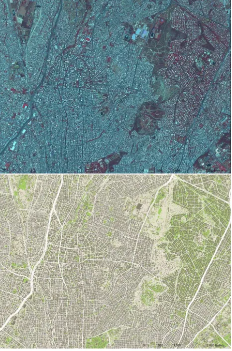
Figure 1: Example of the European settlement information ex-tracted by the GHSL platform from Spot 2.5-m resolution input imagery in Athens (Greece). Top: input image. Bottom: output of the automatic data classification. Dark brown: built-up ar-eas (buildings), green: vegetated open spaces, white: other open spaces
far remote sensing technologies have demonstrated a very limited capacity to map the spatial evolution of the global human settle-ments, involving the integration of a variety of sensors and data classification approaches linked with unknown mutual systematic bias/gain functions.
The density, the heterogeneity, the dynamics of human settle-ments and their interactions with the environment are fundamen-tal pieces of information we need to have at hand to help us keep in balance the use and regenerative capacity of our planets re-sources. But the current picture of the human footprint is in-complete. The majority of small and medium-sized settlements, critical for accounting and understanding the impact of people on the globe, remain largely invisible. The big dots may be visi-ble, but not the all-important connections between them. And the truly vulnerable, such as those dwelling in refugee camps, shan-tytowns and slums are effectively missing from our global under-standing3. The aim of the GHSL project is to contribute to fill these information gaps exploiting remote sensing technologies. In particular, GHSL aims to contribute to a the global assessment of human settlement surfaces and their spatial dynamics, using
3
GEO (Group on Earth Observations), Statement for a Global Human Settlement Partnership 2014 https://www.earthobservations. org/documents/ghs/ghs_brochure.pdf
fine-scale remote sensing data (Pesaresi and Ehrlich, 2009, Pe-saresi et al., 2011, PePe-saresi et al., 2013). Extensive tests using the Landsat data archive of the last 40 years have been conducted during 2014: some first results combining human settlement in-formation extracted from satellite data and population data are showed here.
2. FINE-SCALE REMOTE SENSING OF GLOBAL HUMAN SETTLEMENTS
Despite the large potential of today’s remote sensing technolo-gies, concrete attempts to create fine-scale information layers re-porting about human settlement at the date are only few. On the active remote sensing technology, published examples so far in-clude a method aiming to produceglobal urban area extent us-ing ASAR 75-m-resolution input data (Gamba and Lisini, 2012) and a method aiming to produceglobal urban footprintsusing finer resolution TanDEM-X data (Esch et al., 2013): while very promising, and based on input data with available global cov-erage, these technologies dont have provided yet a global com-plete classification test. On the passive remote sensing technol-ogy, a method aiming toglobal urban area mapping integrat-ing ASTER data at 15m-resolution with extensive GIS data used in post-processing and information masking was proposed in by (Miyazaki et al., 2013). General issues related to these methods are i) the adoption of fixed cut-off in the feature space that are dif-ficult to apply globally and independently from the background landscape or data collection parameters and ii) the adoption of rigid rule-based data masking strategies in the post-processing phase, in order to improve the accuracy of the classification out-put. Post-classification data masking strongly increases depen-dency of the satellite data classification output with third-parties sources: consequent strongly decreases the value added of satellite-derived information.
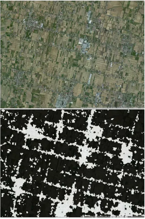
Figure 2: Example of built-up areas extracted from Landsat data processing in the GHSL workflow in the Veneto region (Italy). Top: high resolution image of a scattered settlement pattern. Bot-tom: output of the automatic recognition of built-up areas using 30-m-resolution input Landsat data.
3. THE GHSL PROJECT
The Global Human Settlement project (GHSL) is supported by the European Commission, Joint Research Centre with the objec-tive to design and test new technologies able to generate global fine-scale representations of the physical characteristics of the hu-man settlements. In particular, the GHSL project is focused on innovative automatic image information extraction processes, us-ing metric and decametric scale satellite data input (Pesaresi et al., 2013). The target information collected by the GHSL project is the built-up structure or building, aggregated in built-up ar-eas and then settlements according to explicit spatial composition laws. They are the primary sign and empirical evidences of hu-man presence on the global surface that are observable by current remote sensors. As opposed to standard remote sensing prac-tices based onurban land coverorimpervious surfacenotions, the GHSL semantic approach is continuous quantitative and cen-tered around the presence of buildings and their spatial patterns: thus making the information gathering independent from any ru-ral / urban prior abstract definition (Pesaresi and Ehrlich, 2009). The GHSL project assumes an inclusive concept of the build-ing, including temporary structures observable in refugees and internally displaced people (IDP) camps, and poor structures of shanty towns and slums. From the GHSL methodological per-spective, automatic information gathering processes are the nec-essary conditions for sustainable global detailed surveys, but also
Figure 3: Comparison of the human settlement information ex-tracted from satellite sensors at different spatial resolution in the area of Chicago-Detroit (US). Top:artificial surfacesas reported by the ESA GlobCover using 300-m-resolution MERIS satellite imagery. Bottom: built-up areasas reported by the JRC GHSL using 30-m-resolution Landsat satellite data
In (Pesaresi et al., 2013) the capacity to discriminate built-up ar-eas was demonstrated with optical sensors in the spatial resolu-tion range of 0.5m-10m and an extensive test set including more than 50 millions of square kilometers of mapped surface. The same system was successfully applied using 2.5-m input sensor resolution for producing large national coverages in Brazil (Kem-per et al., 2013) and China (Lu et al., 2013) using CBERS-2B panchromatic data, and continental coverage in Europe (Ferri et al., 2014, Florczyk et al., accepted 2015b) using Spot-5,6 multi-spectral pan-sharpened data. Figure 1 shows an example of the human settlement information extracted by these technologies. To date, these experiments are the largest and most general known attempts to apply automatic data classification techniques for map-ping built-up areas using this class of image data in input. A new inter-scale inter-sensor machine learning methods was in-troduced by (Pesaresi et al., 2013) in the discrete classification field. The aim of the method is to substitute the expensive expert-driven train set data collection with systematic access to open source spatial information already collecting proxies (by scale, by thematic contents) of the information under request. Similar approach in the continuous classification field was independently proposed by (Sexton et al., 2013) for solving the problem of es-timating Global, 30-m resolution continuous fields of tree cover. These learning methods work in the scenario where the whole data universe under processing is labeled by one or more training set data. The approach assumes that modern technology allows researchers to analyse the whole population rather than just in-specting a smaller sample:N, the number of observations in the sample, is equal to all(Mayer-Sch¨onberger and Cukier, 2013). This approach was demonstrated robust against large errors in the training set induced by scale generalization and/or omission, commission errors in the data sources: thus allowing to substi-tute the expert-driven classification parameter tuning with adap-tive optimization techniques automatically estimating the best pa-rameters in the specific scene under process. Similar approach can be used for consistency optimization of the global fine-scale information mosaics (Syrris and Pesaresi, 2013), training semi-supervised classifiers (Li et al., 2014), and image enhancement for optimization of image feature extraction (Syrris et al., Ac-cepted 2015).
While these methods can technically solve global or continen-tal fine-scale mapping scenarios, a data policy access problem still remains: to date no global open and freely accessible data is available in the spatial resolution of 0.5m-10m. Satellite data of this class typically fall inside security and commercial use re-strictions: use licenses are negotiated as per-project budget and conditions, and are difficult to share in the broader global sci-entific community. On-line image streaming platforms distribut-ing global fine-scale data repositories as Bdistribut-ing, Google, Esri can already provide input data suitable for the GHSL automatic im-age information extraction workflow, but various commercial re-strictions are applied for processing the image data on the client side, and on the volume of the image data tiles that can be freely downloaded. During 2014, and extensive experimentation aim-ing to port the GHSL production system from the 0.5m-10m to the 10m-75m resolution range was undertaken. The latter range matches the resolution of today’s available global, open fine-scale satellite data as Landsat and Sentinel. Successful GHSL produc-tion in this spatial resoluproduc-tion range would allow the producproduc-tion of global open human settlement information freely sharable in the scientific and user community. Free and open data access policy is an important value added for remote-sensing applica-tions, facilitating the sharing of the analysis results in the global scientific and user communities, thus augmenting their societal impact and benefit (Wulder and Coops, 2014). In particular, two main streams of experimentation are implemented in the GHSL
Figure 4: Examples extracted from the ALPHA release of the GHSL Landsat Multitemporal. From top to the bottom: Shang-hai, San Francisco, and Paris. In red built-up areas detected be-fore 1975. Orange, yellow, and white encode the built-up areas detected in the 1990, 200, and 2014 epochs
to 15 meters. Figure 2 shows the output of the automatic recog-nition of built-up areas as implemented in the alpha release of the Landsat GHSL. The concept of Human Settlement adopted in this study relay on the classical notion inherited from the set-tlement geography, defined as”...the description and analysis of the distribution of buildings by which people attach themselves to the land.” (Stone, 1965). The building is the basic sign of the human presence that can be physically observable by remote sensing technologies. Consistently with the above approach, the whole classes of settlement used in this study are derived by spa-tial generalization of the basic information about the presence of the building, as detected by the available remotely sensed data. Thebuildingare constructions above ground which are intended or used for the shelter of humans, animals, things, the production of economic goods or the delivery of services. The working def-inition above is a thematic characterization of thebuildingclass as defined by the Infrastructure for Spatial Information in Europe (INSPIRE) standard (Infrastructure for Spatial Information in Eu-rope, 2011). In particular, respect to INSPIRE, theunderground building case was excluded and thepermanencyof built-up struc-tures condition was violated (Pesaresi et al., 2013). The reason of the first change is clearly related to the limit of the adopted remote sensing technology, while the second is related to the application domain. Global security and crisis management applications of-ten require to monitor temporary or semi-permanent settlements as refugee camps, but also informal and poor built-up structures not falling inside the standardbuildingclass. Thebuilt-up area BUΨis the set of all the spatial units collected by the specific
sensor-information-model Ψand containing a building or part of it. The sensor-information-modelΨembeds the spatial de-tail (scale) of the sensor used to extract the thematic information, and the thematic detail (information sensitivity and specificity) allowed by the adopted information extraction method coupled with the available input data characteristics.
Figure 3 shows the comparison of the human settlement informa-tion extracted from satellite sensors at different spatial resoluinforma-tion in the area of Chicago-Detroit (US). At the top theartificial sur-facesas reported by the ESA GlobCover4using 300-m-resolution MERIS satellite imagery. At the bottom it is showed thebuilt-up areasas reported by the JRC GHSL using 30-m-resolution Land-sat Land-satellite data input. It is evident the gain of new information discovered by finer resolution sensors and advanced data classifi-cation techniques. Figure 4 shows the output of the multitemporal information encoded in the GHSL Landsat in three large cities: from top to the bottom Shanghai, San Francisco, and Paris. In red the built-up existing before the 1975. Orange, yellow and white are encoding the 1990, 2000, and 2014 years.
4. THE GEO WORKING GROUP
The JRC GHSL project supports the Global Human Settlement Working Group (GHS WG) in the frame of the Group on Earth Observations (GEO). The scope of the GHS WG is to contribute the GEO task SB-04-C1: Global Urban Observation and Informa-tion by establishing and fostering a new community of practices focused on specific goals. In particular, testing the production and the use of new global human settlement information prod-ucts derived by integration of global remote sensing data, en-vironmental data, population and socio-economic data analysis. The scope is global and multidisciplinary, with a particular em-phasis on testing the use and integration of new global fine-scale information products made available by development of the re-mote sensing technology and the establishment of open public data access policies. The GHS WG is committed to develop a
4
http://due.esrin.esa.int/page_globcover.php
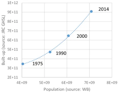
Figure 5: Global population and built-up areas evolution in the last 40 years. The fine-scale built-up areas are estimated by the JRC GHSL using Landsat input imagery
new generation of measurements and information products as-sessing new scientific evidences about global human settlement, and supporting global policy processes with agreed, actionable and goal-driven metrics. In particular, the GHS WG is committed to support the UN Third Conference on Housing and Sustainable Urban Development (Habitat III, 2016), the concurrent post-2015 processes on sustainable development, the UN Framework Con-vention on Climate change and the Hyogo framework for disaster risk reduction.
One important GHS WG objective is to improve the sharing of tools and data in the different expert domains. In October 2014, JRC decided to share among the partners of the working group the alpha release of GHSL Landsat for early testing and model integration activities before the official release planned in 2016. This new information layer was extracted from Landsat global data records of the last 40 years (1975-2015) trough the porting of the GHSL production workflow in the 10m-75m input image resolution range. To date, the user application list of the fine-scale GHSL information includes population spatial modeling, census planning, poverty mapping, slum mapping, regional development and planning, transport planning, urban and global climate mod-eling, spatial epidemics analysis, water analysis, ecological stud-ies, environmental protection, agricultural fragmentation studstud-ies, and historical landscape protection. Their geographical scope may include national, regional/continental, and global coverages as well.
Some preliminary results integrating information extracted from satellite data and population census data are reported here. Fig-ure 5 shows the aggregated global results of population and built-up areas in the years 1975, 1990, 2000 and 2014 as extracted from the World Bank Open Data5and the JRC GHSL sources, respec-tively. It is evident that population and built-up areas are linked by direct relations, with global built-up areas growing more rapidly respect the population growth. This is an empirical evidence that globally we are increasing the amount of built-up space pro-capita. The built-up areas pro-capita can be linked to the land-use efficiency and socio-economical development, demanding pro-portionally more built space for housing and services. Such dy-namical data will be crucial input for understanding and model-ing the evolution of the human settlements in the next years. It is evident that the global trend showed in the Figure 5 averages a
5
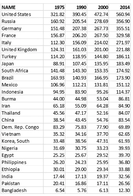
multiplicity of heterogeneous local situations. Figure 6 shows the estimated amount of built-up area pro-capita in the years 1975, 1990, 2000, and 2014 in the Countries with more than 50 millions of inhabitants. It is evident the large global disparity and socio-economical divide between the two extrema of the list: namely the 560 square meters of built-up area per inhabitant in US and the 12 square meters of built-up area pro-capita in Bangladesh. Such data can potentially support the definition of globally-consistent and evidence-based indicators contributing the the monitoring of international policy processes as Sustainable Development Goals (SDGs) and Disaster Risk Reduction (DRR).
Figure 6: Estimated amount of built-up area pro-capita in the years 1975,1990, 2000 and 2014 in Countries with more than 50 millions of inhabitants.
5. CONCLUSIONS
A presentation of the Global Human Settlement Layer (GHSL) project was made. The project has the objective to design and test new technologies able to generate global fine-scale informa-tion about the physical characteristics of the human settlements. In particular, automatic remote sensing data classification tech-niques are applied. The project contributes directly to the disas-ter risk reduction (DRR) indisas-ternational policy processes, but sev-eral other application areas need fine-scale Global Human Set-tlement information. Some examples are provided on the infor-mation extracted from satellite data by the GHSL project, includ-ing preliminary results obtained from the processinclud-ing of the global Landsat archived data in the last 40 years in order to understand global human settlement evolution. The JRC GHSL project sup-ports the Global Human Settlement Working Group (GHS WG) in the frame of the Group on Earth Observations (GEO). The GHS WG is committed to develop a new generation of mea-surements and information products assessing new scientific
ev-idences about global human settlement, and supporting global policy processes with agreed, actionable and goal-driven met-rics. In particular, the GHS WG is committed to support the UN Third Conference on Housing and Sustainable Urban Develop-ment (Habitat III, 2016), the concurrent post-2015 processes on Sustainable Development (SDG), the UN Framework Convention on Climate change and the Hyogo framework for Disaster Risk Reduction (DRR).
ACKNOWLEDGEMENTS
The work presented here is supported by the EC JRC institutional research projectsGlobal Human Settlement Analysis for Disaster Risk Reduction(GLOB-HS) andEuropean Urban Development and Territorial Cohesion(E-URBAN).
REFERENCES
Angel, S., Sheppard, S., Civco, D. L., Buckley, R., Chabaeva, A., Gitlin, L., Kraley, A., Parent, J. and Perlin, M., 2005. The dynamics of global urban expansion. World Bank, Transport and Urban Development Department Washington, DC.
Ban, Y., Gong, P. and Giri, C., 2015. Global land cover map-ping using earth observation satellite data: Recent progresses and challenges. ISPRS Journal of Photogrammetry and Remote Sens-ing.
Chen, J., Chen, J., Liao, A., Cao, X., Chen, L., Chen, X., He, C., Han, G., Peng, S., Lu, M. and et al., 2014. Global land cover mapping at 30m resolution: A pok-based operational approach. ISPRS Journal of Photogrammetry and Remote Sensing.
Esch, T., Marconcini, M., Felbier, A., Roth, A., Heldens, W., Hu-ber, M., Schwinger, M., Taubenbock, H., Muller, A. and Dech, S., 2013. Urban footprint processor—fully automated process-ing chain generatprocess-ing settlement masks from global data of the tandem-x mission. IEEE Geoscience and Remote Sensing Let-ters 10(6), pp. 1617–1621.
Ferri, S., Syrris, V., Florczyk, A., Scavazzon, M., Halkia, M. and Pesaresi, M., 2014. A new map of the european settlements by automatic classification of 2.5m resolution spot data. In: Geo-science and Remote Sensing Symposium (IGARSS), 2014 IEEE International, pp. 1160–1163.
Florczyk, A., Andredakis, I., Freire, S., Ferri, S. and Pesaresi, M., 2015a. Remote sensing datasets supporting disaster alert systems on multiscale via WEB services. In: Geoscience and Remote Sensing Symposium (IGARSS), 2015 IEEE International.
Florczyk, A., Ferri, S., Syrris, V., Kemper, T., Halkia, M., Soille, P. and Pesaresi, M., accepted 2015b. A new european settlement map from optical fine scale remote sensed data. IEEE Journal of Selected Topics in Applied Earth Observations and Remote Sensing.
Freire, S., Ehrlich, D. and Ferri, S., 2014. Assessing temporal changes in global population exposure and impacts from earth-quakes. In: 11th International Conference on Information Sys-tems for Crisis Response and Management (ISCRAM).
Freire, S., Floczyk, A. and Ferri, S., 2015a. Modeling day- and nighttime population exposure at high resolution: Application to volcanic risk assessment in campi flegrei. In: 12th Interna-tional Conference on Information Systems for Crisis Response and Management.
Gamba, P. and Lisini, G., 2012. A robust approach to global urban area extent extraction using asar wide swath mode data. In: Advances in Radar and Remote Sensing (TyWRRS), 2012 Tyrrhenian Workshop on, pp. 1–5.
Gong, P., Wang, J., Yu, L., Zhao, Y., Zhao, Y., Liang, L., Niu, Z., Huang, X., Fu, H., Liu, S. et al., 2013. Finer resolution obser-vation and monitoring of global land cover: first mapping results with landsat TM and ETM+ data. International Journal of Re-mote Sensing 34(7), pp. 2607–2654.
Infrastructure for Spatial Information in Europe, I., 2011. D2.8.III.2 Data Specification on Building.
Kemper, T., Blaes, X., Ehrlich, D., Haag, F. and Pesaresi, M., 2013. On the feasibility to map the settlements of Brazil with the CBERS-2B satellite. In: Urban Remote Sensing Event (JURSE), 2013 Joint, IEEE, pp. 078–082.
Li, J., Gamba, P. and Plaza, A., 2014. A novel semi-supervised method for obtaining finer resolution urban extents exploiting coarser resolution maps. Selected Topics in Applied Earth Obser-vations and Remote Sensing, IEEE Journal of PP(99), pp. 1–12.
Lu, L., Guo, H., Pesaresi, M., Soille, P. and Ferri, S., 2013. Au-tomatic recognition of built-up areas in China using cbers-2B hr data. In: Urban Remote Sensing Event (JURSE), 2013 Joint, pp. 065–068.
Mayer-Sch¨onberger, V. and Cukier, K., 2013. Big data: A revolu-tion that will transform how we live, work, and think. Houghton Mifflin Harcourt.
Miyazaki, H., Shao, X., Iwao, K. and Shibasaki, R., 2013. An automated method for global urban area mapping by integrating ASTER satellite images and GIS data. Selected Topics in Applied Earth Observations and Remote Sensing, IEEE Journal of 6(2), pp. 1004–1019.
Pesaresi, M. and Ehrlich, D., 2009. A methodology to quantify built-up structures from optical VHR imagery. In: P. Gamba and M. Herold (eds), Global Mapping of Human Settlement Experi-ences, Datasets, and Prospects, CRC Press, chapter 3, pp. 27–58.
Pesaresi, M., Ehrlich, D., Caravaggi, I., Kauffmann, M. and Lou-vrier, C., 2011. Towards global automatic built-up area recog-nition using optical VHR imagery. Selected Topics in Applied Earth Observations and Remote Sensing, IEEE Journal of 4(4), pp. 923 –934.
Pesaresi, M., Huadong, G., Blaes, X., Ehrlich, D., Ferri, S., Gueguen, L., Halkia, M., Kauffmann, M., Kemper, T., Lu, L., Marin-Herrera, M., Ouzounis, G., Scavazzon, M., Soille, P., Syrris, V. and Zanchetta, L., 2013. A Global Human Settlement Layer From Optical HR/VHR RS Data: Concept and First Re-sults. Selected Topics in Applied Earth Observations and Remote Sensing, IEEE Journal of 6(5), pp. 2102–2131.
Pesaresi, M., Kemper, T., Gueguen, L. and Soille, P., 2010. Auto-matic information retrieval from meter and sub-meter resolution satellite image data in support to crisis management. In: Geo-science and Remote Sensing Symposium (IGARSS), 2010 IEEE International, pp. 1792 –1795.
Potere, D., Schneider, A., Angel, S. and Civco, D. L., 2009. Mapping urban areas on a global scale: which of the eight maps now available is more accurate? International Journal of Remote Sensing 30(24), pp. 6531–6558.
Sexton, J. O., Song, X.-P., Feng, M., Noojipady, P., Anand, A., Huang, C., Kim, D.-H., Collins, K. M., Channan, S., DiMiceli, C. et al., 2013. Global, 30-m resolution continuous fields of tree cover: Landsat-based rescaling of modis vegetation continuous fields with lidar-based estimates of error. International Journal of Digital Earth 6(5), pp. 427–448.
Stone, K. H., 1965. The development of a focus for the geography of settlement. Economic Geography pp. 346–355.
Syrris, V. and Pesaresi, M., 2013. On the Assessment of Au-tomatically Processing HR/VHR Imagery Using low-resolution Global Reference Data. In: Joint Urban Remote Sensing Event, Sao Paulo, Brazil. in press.
Syrris, V., Ferri, S., Ehrlich, D. and Pesaresi, M., Accepted 2015. Image enhancement and feature extraction based on low resolu-tion satellite data. IEEE Journal of Selected Topics in Applied Earth Observations and Remote Sensing. Accepted.
Taubenb¨ock, H., Esch, T., Felbier, A., Wiesner, M., Roth, A. and Dech, S., 2012. Monitoring urbanization in mega cities from space. Remote sensing of Environment 117, pp. 162–176.
Wulder, M. A. and Coops, N. C., 2014. Satellites: Make earth observations open access. Nature 513(7516), pp. 30–31.