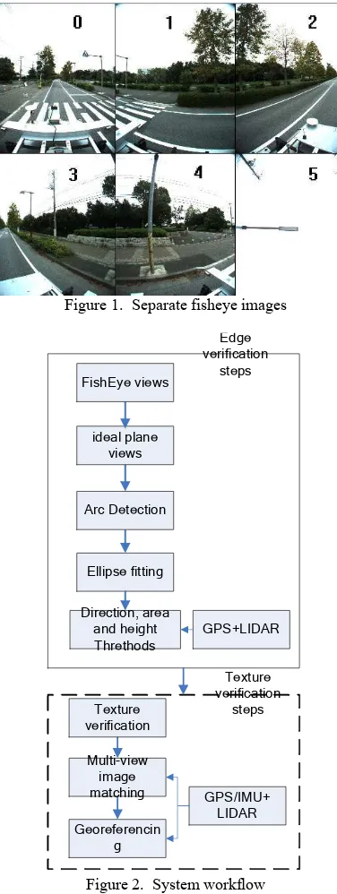
!"##!$ % & '###()*"+
% , - , -
( + . - + +&
/ + , - %
-0 ( + +&
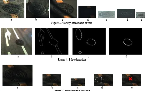
!"! # $ !%&' %"
( ) * 1 1 1 1 .
2 3 3 . 3 4 5
. 3 67 8 9 : /2 + ,
0 3 + ; 3
4 3
+ , 3 4
+ , : /2 4
+ 2 3
4 + ,
& - + 9 )### 3
0 + ,
4 +
% +
+,
9
+ ,
- .
+ , 3
+ < 3
3 3 + 2 3
3 3
= . >, '##"?+ ; 3
3 3
+ , 3
+
% 3 .
3
+ 9
0
+ +
,
+ % ;
>% '##*?+ : 5
4 4
>: '#)#?+
; 3 3
4
- 3
+
+
3 +
3 . 3
. 67 8 9 : /2
+ '+) 3 - 3 '+'
'+"
-+ '+! . 3
- "/ + +"
3 ))## . 3 67 8 9
: /2
! 3 +
-, )
-,+ % # ! !% . &/0 .
, . :
>: '#)'? 5 5 + ,
4 + @ +#A!
3 B' 3 @ +C
- > D + )?+
@ +# ) ! + 67 8 9 3
4
> < ? 4 + , : /2
+
, 3 - 3 D + ' 3
4 + .
International Archives of the Photogrammetry, Remote Sensing and Spatial Information Sciences, Volume XXXIX-B3, 2012 XXII ISPRS Congress, 25 August – 01 September 2012, Melbourne, Australia
76 :
4 + ,
/ <@ >9 6 '##)?
+ , 5
+ , 4
- 4
3 3 + 4
4 4
4 - 4 + ,
3
3 67 8 9 +
D )+
! " #
# $ !%
& '
D '+ 3 - 3
-,- & # % %"
, + ; 3
3 4
3 + ,
3 3 + D
3 3 3
+ <
. - +
D )#'! C'B 4 4
4 + / <@
+ , 3 3 "
!#+ , . 4
;
0 3 + 2
- - +
-,$ " ! 0"%%" 1 # %2& !2 #!
9 4
4 + ,
0
+ , 5 3 - 3
4 4 3 3
2@ 2% >D E )$F)?
+ 2
3 + E
4 -
+ !C +
D 4 3 #+C
) #+" #+$ G +
, & 3
3 + , : /2
+ #+'
3 4
+
-, ' %" 3" . % 2" 1 # %" 1
4 4
- +
+ / 3
+ . 3 &
. 3
67 8 9 +
E 4
+ , 4 3
C#+ ; 3
> D + " ?+
3 +
,
-3 + ,
- 5+'
5+) 3 + 5+) )
) ) 4
3 67 8 9
+ ' ' '
+ % 3 : /2
5+) 3 - 3 +
International Archives of the Photogrammetry, Remote Sensing and Spatial Information Sciences, Volume XXXIX-B3, 2012 XXII ISPRS Congress, 25 August – 01 September 2012, Melbourne, Australia
? > ' ' '
) )
) >)?
? > ) ) ) ' '
'
) )
) >'?
2 5+'
+ , 5
3
+ ,
-3 3 + D 3
/ <@ +
2 & 3
3 3 3 4 +
, 3
3 < 67 8 9 +
/ < 3
9 #+' +
3 3 + ,
- 3 3
' & + ,
4 > D + C ?+ 3
3 =
+
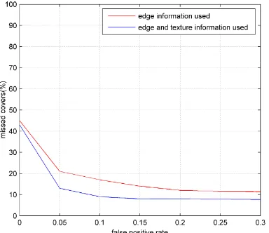
$, 45
$,+ !% # %
, ))## '*
+ 4 4
0 3
3 + , 67
#+#C 9
"# + , : /2 #+#C
3 *# +
D "+ I
D !+
D C+ 9
$,- #1 # % %" 3 ' %"
2 4 / <@
4 3
! ! + ,
+ *#J
3 9 ' 4 3
+ + ! "
B + < 3
+ 4
4 3 + !
+
, + * 3
>D7? + D7
3 + D7 #+#C
B$J+
3 4 / <@
+
$,$ % 2" 1 # %" 3 ' %"
, & 3
+ , 3
4 + D
3 3 &
* 3 4 > D +
C ?+ 3 + ,
+ C 3 3
>3 ? + , D + C 3
International Archives of the Photogrammetry, Remote Sensing and Spatial Information Sciences, Volume XXXIX-B3, 2012 XXII ISPRS Congress, 25 August – 01 September 2012, Melbourne, Australia
3 3 67 8 9
+ ; 3
-+
, + * 3
>D7? 4 + ,
FFJ #+#C D7
& - 4 + 9
67 9 +
D *+ ,
4
$, "! '!!"
, 3
-4 + ,
3
. 3 3 0 +
, >% '##*1 :
'#)#? 3 & +
9
D7+
, . 3 . 3 >
: '#))?
+ ; 3 3
. +
2 > : '#))?
D / >% '##$?
3 +
< + ,
3
+ + "
+ D 3 +
,
9 4
+ .
3 67 9 : /2
+ , / <@
4
+ , "/
3 67 8 9 +
, 3 - 3 3
-.
+
/ . #1 %!, , 3
-% $B" >'#)'%EB)$$#'?+
0 & !
% 2+ + %+ + : +%+ % + + ; 7+%+
'##$+ K
3 K +
+ )F$$.)$#"+
% + L + +;+ '##*+
=
+ ! " # $ " % & "'>'##*? + C#!. C#F+
D 9+2+ E + %+ )$F)+
% M 2 7 9 D 3 2
2 2 % + '!>*? +
"F)."$C+
: +;+ '#))+
0
. + % " %
$ " % & 'F>F? + ")"F.")!#+
9 7+ 6 E+ '##)+ 3
+ ''' % % ( )% %
" '">)'? + )"C).)"*C+
,+ : I+6+ '#))+ 9 . 3
"/ + '''
* % + %" % ,-.. + )FF.)$C+
, @ '##"+ 9
+ ''' % %)% '>)'? )CC'.)CCC+
:2/ E 6 M88333+ + 8 8 + + >'
9 + '#)'?
International Archives of the Photogrammetry, Remote Sensing and Spatial Information Sciences, Volume XXXIX-B3, 2012 XXII ISPRS Congress, 25 August – 01 September 2012, Melbourne, Australia