Vol. 1, No. 1 (2017): International Journal of Disaster Management - 46
Estimation of Site Amplifications from Shear-Wave Velocity
at Pyroclastic deposits and Basins in Aceh Tengah and Bener
Meriah District, Aceh Province, Indonesia
Ibnu Rusydy
1,6, Khaizal Jamaluddin
2,3, Eldina Fatimah
3,6, Syafrizal
2,4,
Fauzi Andika
5, & Yoshinori Furumoto
61 Department of Geological Engineering, Faculty of Engineering, Syiah Kuala University, Banda
Aceh, Indonesia
2 Department of Geophysical Engineering, Faculty of Engineering, Syiah Kuala University, Banda
Aceh, Indonesia
3
Department of Civil Engineering, Faculty of Engineering, Syiah Kuala University, Banda Aceh, Indonesia
4 Physics Master Program, Post Graduate Program, Syiah Kuala University, Banda Aceh, Indonesia 5
Geophysics Section, School of Physics, Universiti Sains Malaysia, Malaysia
6
Tsunami And Disaster Mitigation Research Center, Syiah Kuala University, Banda Aceh, Indonesia
7
National Institute of Technology, Nagano College, Japan
*Corresponding author: [email protected]
Abstract. Earthquake on July 2, 2013, destroyed several buildings in Aceh Tengah district and Bener Meriah district of Aceh Province. This earthquake gives Aceh government a clue that the seismic hazard map must become the reference in development plan in future. To respond this idea, we conduct the research and try to estimate the amplification factor for developing seismic hazard maps of those districts. This study aims to determine the average shear wave velocity up to the depth of 30 meters (Vs30) and the amplification factor of Aceh Tengah district and Bener Meriah district, to build the seismic hazard map of both districts. In this study, we use the MASW (Multi-Channel Analysis of Surface Waves) with 24 geophones in the frequency of 10 Hz at 10 locations to determine the Vs30 beneath the surface. The soil and rock classification from ASCE 2010 and SNI 1726:2012 used to classify the soil/rock based on Vs30 and calculate the predicted amplification factor using the Borcherdt & Eeri equation. The result of this study reveals that the range of Vs30 in the study area is 76 m/s – 308 m/s. The loosest sediment has 76 m/s located at point 2 in Aceh Tengah district. The shear wave velocity of 76 m/s classify as soft soil (SE). Based on the calculation, the pyroclastic deposit and sediment in basin of the study area will be amplified the seismic wave in range of 2.9 to 3.3 times. In the future, we suggest conducting another geophysical survey to determine the correct amplification factor to improve the quality of seismic hazard map.
Keywords: Amplification Factor, Shear-Wave, MASW, Aceh Tengah, and Bener Meriah
1. Introduction
July 2, 2013, Earthquake struck Aceh Tengah district and Bener Meriah district of Aceh province. From this event we learned about the dangers of Sumatra Fault Zone (SFZ) earthquakes and how it profoundly damaged buildings. Shallow crustal earthquake in SFZ is close to the residential population and resulting high intensity ground shaking with highly destructive effect. Despite the relatively small-scale of earthquake magnitude, nevertheless it was highly destructive because the source of the earthquake is quite shallow, while many houses and buildings lay on soft soil. Soft soil may cause the amplification effect to the earthquake waves.
Vol. 1, No. 1 (2017): International Journal of Disaster Management - 47 Standard on Earthquake Resilience Planning Procedures for Building (SNI 03-1726: 2002) with a new Indonesia Standard of SNI 03-1726: 2010 (Tim Revisi Peta Gempa Indonesia, 2010)
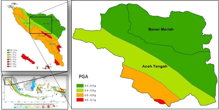
Indonesia seismic hazard map 2010 only calculates peak ground acceleration of earthquake at the bedrock (fig. 1). For the purposes of earthquake resistant infrastructure planning, required peak ground acceleration (PGA) on the surface. Currently, the American Society of Civil Engineers (ASCE/SEI 7-10, 2010) has provided the amplification factor for each type of soil that refer to SNI 03-1726: 2010. In another way, the amplification factor can be estimated using the equation that proposed by Borcherdt & Eeri (1994). The amplification factor is used for the planning needs of earthquake resistant buildings. The value of peak ground acceleration on the surface is obtained by multiplying the value of the acceleration Indonesia seismic hazard map 2010 with the amplification factor which depends on the type of soil (Aldiamar, Ridwan, Asrurifak, & Irsyam, 2010). Fig 1 shows the value PGA in Aceh Tengah district and Bener Meriah district in the range of 0.4 – 0.7 g.
The soft soil effect that can cause the amplification factor, therefore, it has to be mapped and studied further. For this reason, the study of shear-wave velocity (Vs) analysis using MASW (Multichannel Analysis of Surface Waves) conducted in several points in Aceh Tengah district and Bener Meriah district of Aceh province. Most of the points located in the relatively young sedimentary basin referred to the Holocene epoch in geological time scale (Cameron, et al., 1983). The soft soil in young sediment will trigger the amplification, allowing classification of soil type by using MASW method. Additionally, Rusydy et al., (2015) also revealed a new fault that far away from Sumatra Fault Zone and it was laid down beneath Aceh Tengah capital city or Takengon City and determination of amplification factor become crucial to build back better.
Figure 1. Peak Ground Acceleration in bedrock for Aceh Tengah and Bener Meriah Seismic Hazard Map with Spectral period = 1 second for 2% probability of exceedance (PE) in 50 years in bedrock
(Tim Revisi Peta Gempa Indonesia, 2010).
2. Geology of Study Area
According to Geological map scale of 1:250,000 which developed by Cameron, et al., (1983), Aceh Tengah and Bener Meriah district were a part of the geological map of Takengon Quadrangle, Sumatra. Aceh Tengah district has similar complexity in geological condition with Bener Meriah district. On the west side of Lake Lot Tawar, there are deposits of alluvium and deposition of the volcanic fan in quarter periods in specific of Holocene epoch (Qh) or formed about 10,000 years ago. These deposits found in Kebayakan sub-district (Takengon City), Bebesan sub-district, Bies sub-district and some part of
Vol. 1, No. 1 (2017): International Journal of Disaster Management - 48 Pegasing sub-district. The sediments in Holocene epoch categories as a young sediment in geological time scale. This sediment is a loose and soft sediment and less consolidate. In addition, in Ketol sub-district and Silih Nara sub-distric, found the ancient pyroclastic deposit consist of sand, tuff, breccia, and conglomerates that formed in the quarter period. This quarter period deposit indicated as the soft and loose sediment.
The oldest rocks found in Aceh Tengah district formed during the Carboniferous at late Paleozoic (248 million years ago). These rocks form the hilly side of Southern part of Aceh Tengah district. This formation including metamorphic rock, consisting of Quartzite, phyllite, and Skist. The intrusive and extrusive of igneous rock were found in Aceh Tengah district that composed of andesite, rhyolites, basalts, and tetra fine-grained and coarse. This igneous rock form about 206 million years ago in Jurassic Mesozoic era and a part of Woyla Group. Overall, sedimentary rocks are dominated in Aceh Tengah district. Sedimentary rocks that formed hills side consist of sandstone, shale (shale), silt stone, mudstone, conglomerate rock and limestone in the age of Quaternary and Tertiary period.
In Bener Meriah district, there is Bur Ni Telong and Bur Ni Geuredong volcano and the most area of this district found the volcanic rock such as andesite, basalt, and fine-grained and coarse teftra, it is known as Enang Enang unit (QVee). On the wasters side of Lampahan sub-district and eastern of Pondok sub-distric, found young volcanic deposits due to past eruption that occurrence about 1.8 million years ago. These deposits consist of sand, tuffa, breccia and conglomerate that from the quarter period. On the westes side recognize as Lampahan unit (QVL) and the Easter side as Pepanji unit (Qvp).
In addition, in Bener Meriah district, there are the mountains that dominated by metamorphic rocks formed during Late Permian, Paleozoic era (about 290 million years ago). This metamorphic rock consists of quartzite, phyllite, and Skis int the southern part of Bener Meriah district. These metamorphic rocks immediately adjacent to the limestone at Tawar Unit (MPt). On the eastern side of Bener Meriah found the mountains that formed by sedimentary rocks such as sandstone, shale (shale), silt stone, mudstone, conglomerate and limestone.
3. Methodology
3.1. MASW Method
MASW (Multi-Channel Analysis of Surface Waves) is a geophysical method that utilizes surface waves to study the subsurface conditions. This method was first introduced by Park et al., (1996) and developed at the Kansas Geological Survey (KGS). MASW method capable of calculating the shear wave velocity (Vs) based on surface wave velocity of the reyleigh wave. The Rayleigh wave is surface waves that easily observed using seismic equipment with vertical geophones; this is because of 2/3 of seismic energy created will form into the reyleigh wave, and these seismic waves accommodate most of the seismic energy (Heisey, Stokoe II, & Meyer, 1982).
In this study, there are 10 points of MASW measurement in different basins and pyroclastic deposit in Aceh Tengah district and Bener Meriah district. Before conduct the measurement, the position each point have to define and design using GIS software. Ten selected location of MASW measurement input into navigation GPS (global positioning system). In data acquisition process, all selected point located using navigation GPS. In targeted point, the line of MASW measurement design according to field condition. The measurement process should be carried out on non-seismic noise condition. This standard conducted to avoid the interference of seismic waves (noise) from the traffic, people walking, and another noise (Rusydy, Khaizal, Fatimah, Syafrizal, & Andika, 2016).
Vol. 1, No. 1 (2017): International Journal of Disaster Management - 49
The data processing was performed in the laboratory using software SeisImager for each measurement points. The data processing phase includes; (1) Export seismic data from equipment to software, (2) Develop dispersion curves which indicate the frequency value of the velocity of seismic waves from the overall 24 geophones, (3) perform a dispersion curve inversion process to obtain subsurface models with RMS (root mean square), (4) Subsurface models of shear wave against the depth.
Figure 2. Process of MASW Seismic measurements using seismometers 24 geophones (Rusydy, Khaizal, Fatimah, Syafrizal, & Andika, 2016)
3.2. Shear Wave
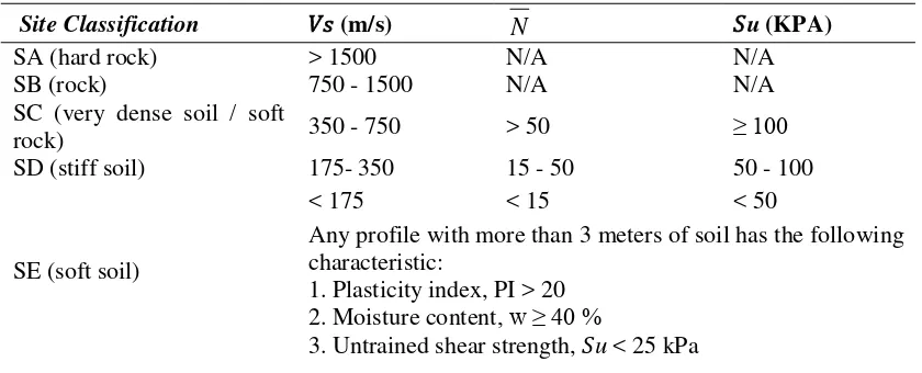
Shear waves is a body wave and often referred to as the S wave which means Secondary or Shear. Named secondary waves because speed is lower than the P waves (primary or pressure). In a solid medium, the shear wave propagates at the speed of 3-4 km /sec (Thompson & Turk, 1998). Shear wave is one important parameter in determining the strength of the earthquake, soil amplification, liquefaction and mapping of subsurface conditions to the needs of the engineering field (Park, Miller, & Xia, 1997; Xia, Miller, Park, Hunter, & Harris, 2000; Ismail, Denny, & Metwaly, 2014; Rusydy, Khaizal, Fatimah, Syafrizal, & Andika, 2016). In ASCE (2010) and SNI 1726: (2012), the parameters of shear wave velocity (Vs) has been incorporated and became one of the parameters in determining the classification of soils and rocks. The classification of soil and rock types based on the ASCE 2010 and SNI 1726: 2012 is widely used for the planning of buildings and non-buildings that will replace conventional methods such as CPT (Cone Penetrating Test) and SPT (Standard Penetrating Test).
Table 1. Soil and rock classification according to ASCE (2010) and SNI 1726 (2012)
Site Classification �� (m/s)
N
�u (KPA)SA (hard rock) > 1500 N/A N/A
SB (rock) 750 - 1500 N/A N/A
SC (very dense soil / soft
rock) 350 - 750 > 50 ≥ 100
SD (stiff soil) 175- 350 15 - 50 50 - 100
SE (soft soil)
< 175 < 15 < 50
Any profile with more than 3 meters of soil has the following characteristic:
1. Plasticity index, PI > 20 2. Moisture content, w ≥ 40 %
Vol. 1, No. 1 (2017): International Journal of Disaster Management - 50
Site Classification �� (m/s)
N
�u (KPA)SF (Soil requiring site-specific ground motion response evaluation.
- Peats of highly organic clays with thickness more than 3 meters.
- Very high plasticity clay (H > 7.5 meter with PI > 75) - Very thick soft/medium stiff clay (H > 35 meter)
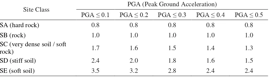
Table 1 shown the classification of soil and rock based on shear wave velocity (Vs). In this study, we able to calculate the shear wave velocity each point in different depth but only the average shear wave velocity in depth of 30 meters (Vs30) that used to produce the seismic map. The average of Vs used to calculate the amplification factor refer to ASCE 2010 and SNI 1726: 2012 that shown in Table 2.
Table 2. Amplification factor in different site class at 1-s Period (ASCE/SEI 7-10, 2010; SNI 1726, 2012)
Site Class PGA (Peak Ground Acceleration)
PGA ≤ 0.1 PGA ≤ 0.2 PGA ≤ 0.3 PGA ≤ 0.4 PGA ≤ 0.5
Determining the amplification factor from Vs30 data, also can be calculated used Borcherdt & Eeri
(1994) equation (1) in considering Aceh Tengah and Bener Meriah district will affect the mid-short
period of the earthquake (1-s period).
�� = [ ��5 ]�� (1)
Fv is the mid-short period of the amplification factor, 1050 is shear wave velocity firm to hard rock and
mw is the value depend on peak ground acceleration (PGA). PGA 0.3 and 0.4, the value of mw will be 0.53 and 0.45.
4. Result
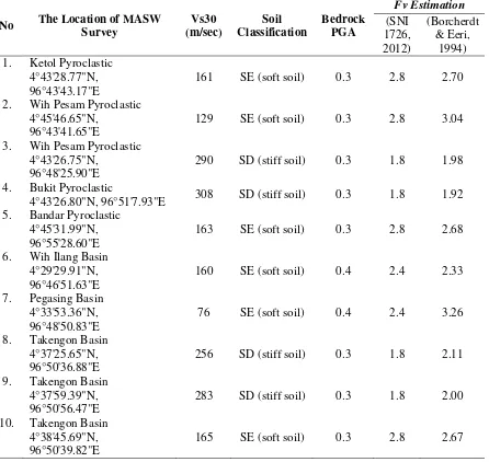
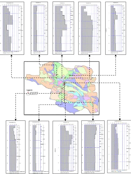
The MASW measurement conducted in 10 locations in both districts in sedimentary layer either Basin or Pyroclastic deposit area. The result showed the range of Vs average is 76 m/s to 308 m/s. The loosest sediment has 76 m/s located at location 7 at Pegasing Basin in Aceh Tengah District. According to Table 1, 76 m/s of Vs classify as soft soil (SE). The higher Vs average is 308 m/s where located at hillside pyroclastic deposit in Bener Merah district. The result of MASW measurement in Aceh Tengah district and Bener Meriah district shown in table 3 and figure 3. Figure 3 shown the Vs30 value againt the depth in an earch location in Bener Meriah and Aceh Tengah district. In this result we can interprete the layering in each location and the average of a shear wave up to 30 meters benearth the surface.
Vol. 1, No. 1 (2017): International Journal of Disaster Management - 51 amplification factor. In otherway, the calculation using Borcherdt & Eeri (1994) equation in that location will produce 3.26 times of amplification factor.
Table 3. The result of Vs30 and amplification factor (Fv) according to (SNI 1726, 2012) and calculation using (Borcherdt & Eeri, 1994) equation.
Vol. 1, No. 1 (2017): International Journal of Disaster Management - 52 Figure 3. The 10 location of MASW measurement in Aceh Tengah district and Bener Meriah district
and the 1-D Vs model each point up to the depth of 30 meters.
Vol. 1, No. 1 (2017): International Journal of Disaster Management - 53 Wih Ilang basin located in Pegasing sub-district and form by swarm sediment. This area categorized as soft sediment and has 160 m/s of Vs30. Considering the PGS in bedrock about 0.4g, this area will able to amplify up to 2.3 to 2.4 times of ground shaking. In another part, Pegasing basin has very soft sediment and has 76 m/s of Vs from the surface to 30 meter depth. This condition put Pegasing basin as the higher prone area to seismic ground shaking. The amplification factor in this basin is 3.26. It means, the ground shaking will increase 3.26 times compared to hard rock area. The last three area located in Takegon basin which a part of Lot Tawar lake and its the capital city of Aceh Tengah district. Lateraly, Takegon has heterogenous sediment due to sedimentation process. The young sediment that closes to hill side less consolidated compared to older sediment in the center part of the basin. The detailed analysis of this basin has been discussed by Rusydy, et al. (2016) but in overall, Takengon basin would amplify more than 2 times when the earthquake struck the city.
In overall, the higher amplification factor located at basin and pyroclastic area in Aceh Tengah district and Bener Meriah district. The lower value of amplification factor located in a hilly area which consists of hard soil/sediment and rock.
5. Conclusion
The seismic MASW capable of determining the shear wave velocity (Vs) beneath the surface based on Rayleigh wave propagation. The resulting yield in MASW survey either 1D Vs Model or 2D Vs model. In this study, only the 1D Vs model that used to determine the amplification factor. In some location, the amplification factor is high, and we suggested to conduct another geophysical method to correct this amplification factor.
According to SNI 1726: (2012), surface Peak Ground Acceleration was the multiple values between Peak Ground Acceleration in bedrock and amplification factor. there is a different amplification factor between SNI 1726: (2012) and Borcherdt & Eeri (1994) equation, to build the detail seismic hazard map, we recommended to use Borcherdt & Eeri (1994) equation. This amplification factor uses to build the seismic hazard map for both districts. The seismic hazard map can be used in the development plan and building design for both districts. More detail about design acceleration parameters, seismic design for building the structure, please refer to SNI 1726:2012 about “Tata Cara Perencanaan Ketahanan Gempa Untuk Struktur Bangunan Gedung dan Non Gedung”.
Acknowledgements
The authors are grateful to say thank you so much to the staff of Aceh Development Planning Agency for help in conducting the MASW survey. This study will be impossible without supporting funding and collaboration program between Syiah Kuala University and Aceh Development Planning Agency of Aceh government.
References
Aldiamar, F., Ridwan, M., Asrurifak, M., & Irsyam, M. (2010). Analisis Dan Evaluasi Factor Amplifikasi Percepatan Puncak Gempa Di Permukaan Tanah. Jurnal jalan-jembatan, 27(3), 180-194.
ASCE/SEI 7-10. (2010). Minimum Design Loads for Buildings and Other Structures. Virginia: American Society of Civil Engineers.
Vol. 1, No. 1 (2017): International Journal of Disaster Management - 54 Cameron, D. R., Bennet, J. D., Bridge, D. M., Clarke, M. G., Djunuddin, A., Ghazali, S. A., . . .
Thomson, S. J. (1983). Geologic 1:250,000 Map of Takegon Quadragle, Sumatra. Bandung: Geological Research and Development Centar (GRDC).
Heisey, J. S., Stokoe II, K. H., & Meyer, A. H. (1982). Moduli of pavement systems from spectral analysis of surface waves. Transportation Research Record , 22-31.
Ismail, A., Denny, F. B., & Metwaly, M. (2014). Comparing continuous profiles from MASW and shear-wave reflection seismic methods. Journal of Applied Geophysics, 67-77.
Park, C. B., Miller, R. D., & Xia, J. (1996). Multi-channel analysis of surface waves using Vibroseis.
66th Ann. Mtg. of SEG, (pp. 68-71). Denver.
Park, C. B., Miller, R. D., & Xia, J. (1997). Multi-Channel Analysisof Surface Waves (MASW) "A summary report of technical aspects, experimental results, and perspective. Kansas: Kansas Geological Survey.
Rusydy, I., Khaizal, Fatimah, E., Syafrizal, & Andika, F. (2016). Studi Awal: Analisa Kecepatan Gelombang Geser (Vs) Pada Cekungan Takengon Dalam Upaya Mitigasi Gempa Bumi.
Jurnal Teknik Sipil Universitas Syiah Kuala, 5(3), 1-12.
Rusydy, I., Syamsidik, & Pagihariyadi, P. (2015). Pemetaan Makroseismik Untuk Pendugaan Sumber Gempa Bumi, Studi Kasus: Gempa Bumi Aceh Tengah 2 Juli 2013. Proseding Konferensi Nasional FPT PRB (pp. 15-20). Surakarta: LPPKM, Universitas Sebelas Maret.
SNI 1726. (2012). SNI 1726: 2012 Tentang Tata Cara Perencanaan Ketahanan Gempa Untuk Struktur Bangunan Gedung dan Non-Gedung. Jakarta: Badan Standarisasi Nasional.
Thompson, R. G., & Turk, J. (1998). Introduction to Physical Geology (2nd ed.). California: Saunders College Pub.
Tim Revisi Peta Gempa Indonesia. (2010). Ringkasan Hasil Studi Tim Revisi Peta Gempa Indonesia 2010. Jakarta: BNPB, AIFDR, RISTEK, DPU, ITB, BMKG, LIPI, ESDM.