Open Geospatial Consortium
Submission Date:2014-11-26 Approval Date: 2014-12-05 Publication Date: 2015-01-21
External identifier of this OGC® document:http://www.opengis.net/doc/WP/smart-cities-sif Internal reference number of this OGC® document: 14-115
Category: OGC®White Paper Editor: George Percivall
OGC Smart Cities Spatial Information Framework
Copyright notice
Copyright © 2015 Open Geospatial Consortium
To obtain additional rights of use, visit http://www.opengeospatial.org/legal/.
Warning
This document is not an OGC Standard. This document is an OGC White Paper and is therefore not an official position of the OGC membership. It is distributed for review and comment. It is subject to change without notice and may not be referred to as an OGC Standard. Further, an OGC White Paper should not be referenced as required or mandatory technology in procurements.
Document type: OGC® White Paper
License Agreement
Permission is hereby granted by the Open Geospatial Consortium, ("Licensor"), free of charge and subject to the terms set forth below, to any person obtaining a copy of this Intellectual Property and any associated documentation, to deal in the Intellectual Property without restriction (except as set forth below), including without limitation the rights to implement, use, copy, modify, merge, publish, distribute, and/or sublicense copies of the Intellectual Property, and to permit persons to whom the Intellectual Property is furnished to do so, provided that all copyright notices on the intellectual property are retained intact and that each person to whom the Intellectual Property is furnished agrees to the terms of this Agreement.
If you modify the Intellectual Property, all copies of the modified Intellectual Property must include, in addition to the above copyright notice, a notice that the Intellectual Property includes modifications that have not been approved or adopted by LICENSOR. THIS LICENSE IS A COPYRIGHT LICENSE ONLY, AND DOES NOT CONVEY ANY RIGHTS UNDER ANY PATENTS THAT MAY BE IN FORCE ANYWHERE IN THE WORLD.
THE INTELLECTUAL PROPERTY IS PROVIDED "AS IS", WITHOUT WARRANTY OF ANY KIND, EXPRESS OR IMPLIED, INCLUDING BUT NOT LIMITED TO THE WARRANTIES OF MERCHANTABILITY, FITNESS FOR A PARTICULAR PURPOSE, AND NONINFRINGEMENT OF THIRD PARTY RIGHTS. THE COPYRIGHT HOLDER OR HOLDERS INCLUDED IN THIS NOTICE DO NOT WARRANT THAT THE FUNCTIONS CONTAINED IN THE INTELLECTUAL PROPERTY WILL MEET YOUR REQUIREMENTS OR THAT THE OPERATION OF THE INTELLECTUAL PROPERTY WILL BE
UNINTERRUPTED OR ERROR FREE. ANY USE OF THE INTELLECTUAL PROPERTY SHALL BE MADE ENTIRELY AT THE USER’S OWN RISK. IN NO EVENT SHALL THE COPYRIGHT HOLDER OR ANY CONTRIBUTOR OF
INTELLECTUAL PROPERTY RIGHTS TO THE INTELLECTUAL PROPERTY BE LIABLE FOR ANY CLAIM, OR ANY DIRECT, SPECIAL, INDIRECT OR CONSEQUENTIAL DAMAGES, OR ANY DAMAGES WHATSOEVER RESULTING FROM ANY ALLEGED INFRINGEMENT OR ANY LOSS OF USE, DATA OR PROFITS, WHETHER IN AN ACTION OF CONTRACT, NEGLIGENCE OR UNDER ANY OTHER LEGAL THEORY, ARISING OUT OF OR IN CONNECTION WITH THE IMPLEMENTATION, USE, COMMERCIALIZATION OR PERFORMANCE OF THIS INTELLECTUAL PROPERTY. This license is effective until terminated. You may terminate it at any time by destroying the Intellectual Property together with all copies in any form. The license will also terminate if you fail to comply with any term or condition of this Agreement. Except as provided in the following sentence, no such termination of this license shall require the termination of any third party end-user sublicense to the Intellectual Property which is in force as of the date of notice of such termination. In addition, should the Intellectual Property, or the operation of the Intellectual Property, infringe, or in LICENSOR’s sole opinion be likely to infringe, any patent, copyright, trademark or other right of a third party, you agree that LICENSOR, in its sole discretion, may terminate this license without any compensation or liability to you, your licensees or any other party. You agree upon termination of any kind to destroy or cause to be destroyed the Intellectual Property together with all copies in any form, whether held by you or by any third party. Except as contained in this notice, the name of LICENSOR or of any other holder of a copyright in all or part of the Intellectual Property shall not be used in advertising or otherwise to promote the sale, use or other dealings in this Intellectual Property without prior written authorization of LICENSOR or such copyright holder. LICENSOR is and shall at all times be the sole entity that may authorize you or any third party to use certification marks, trademarks or other special designations to indicate compliance with any LICENSOR standards or specifications. This Agreement is governed by the laws of the Commonwealth of Massachusetts. The application to this Agreement of the United Nations Convention on Contracts for the International Sale of Goods is hereby expressly excluded. In the event any provision of this Agreement shall be deemed unenforceable, void or invalid, such provision shall be modified so as to make it valid and enforceable, and as so modified the entire Agreement shall remain in full force and effect. No
Contents
1. A Spatial Information Framework for Smart Cities? ... 5
2. Smart City Information Enterprise ... 6
2.1 What’s so smart about Smart Cities? ... 6
2.2 Indicators for city services and quality of life ... 7
2.3 Smart City Applications ... 9
2.4 Smart City Enterprise framework ... 10
3. Spatial Information and Smart Cities ... 11
3.1 Spatial information is pervasive and primary ... 11
3.2 CityGML and IndoorGML ... 12
3.3 LandXML and InfraGML ... 15
3.4 Building Information Models ... 16
4. Interoperability Services for Smart Cities ... 17
4.1 Geospatial Services Architecture ... 17
4.2 Sensor Web Enablement and SensorThings ... 17
4.3 Data Access Services ... 18
4.4 Processing Services ... 18
4.5 Catalogue Services ... 19
4.6 Workflow ... 19
4.7 Context Document and GeoPackage ... 19
4.8 Visualization and Augmented Reality ... 20
5. Development of Spatial Information Framework for Smart Cities ... 21
5.1 Spatial Information Architecture for Smart Cities ... 21
5.2 OGC Smart City Interoperability Initiatives – Testbeds, Pilots etc. ... 21
5.3 Deploying the Spatial Information Framework for Smart Cities ... 22
Annex A. Open Standards Coordination for Smart Cities ... 27
A.1 OGC coordination with other Standards Developing Organizations ... 27
A.2 International Standards activities on Smart Cities ... 28
A.3 National Standards Activities ... 30
Abstract
This White Paper supports development of a Smart Cities Spatial Information Framework based on these themes:
K Smart Cities are high-density generators of innovation and information.
K Location information is a major enabler of Smart City technology benefits.
K Benefits of smart technology must be judged by benefits to residents.
K Reuse and repurpose is vital to urban resilience
K Open standards are needed for interoperability, efficiency, application innovation and cost effectiveness.
Discussion of these themes and this white paper will occur at the OGC Smart Cities Location Powers Summit in Tokyo on December 2, 2014,1 the co-located OGC Technical Committee meeting, and in many other forums in the future. As described in this paper, there are many standards initiatives that focus on Smart Cities. Most Smart Cities use cases in some way involve indoor and/or outdoor location, and thus communication about location is an issue that cuts across the work programs most of the standards
organizations that are involved with Smart Cities.
This white paper builds on the OGC - Directions Magazine webinar: “Making Location Work for Smart Cities – the Case for Location Standards”2.
Keywords
ogcdoc, OGC documents, smart cities, recreation, energy, renewable energy, citygml, indoorgml, landinfra, infragml. bim, wfs, wcs, sos, sensorml, sensorthings, o&m, kml, wms, sld, wmts, arml, iso, jtc1, din
Submitters of this document
All questions regarding this white paper should be directed to the editor or the submitters:
Name Affiliation
George Percivall OGC
Carsten Rönsdorf Ordnance Survey
Steve Liang University of Calgary
Denise McKenzie OGC
Lance McKee OGC
1http://www.locationpowers.net/ 2
1.
A Spatial Information Framework for Smart Cities?
Today, urban population accounts for 54 percent of the total global population (World Health Organization 2014) with a trend to more urbanization. Effective integration of human, physical, and digital systems operating in the built environment holds the promise of improving the quality of life of urban residents, improving the governance of cities and making cities prosperous, inclusive, sustainable and resilient. Location is a primary method for organizing Smart City services. Communicating anything about location requires standards. This paper addresses the open information technology standards framework that is critical to achieving the benefits of spatial communication for Smart Cities.
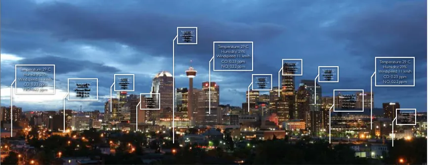
Figure 1. A Smart City uses location as an organizing principal to benefit residents, visitors, and businesses of all types. (Graphic from Steve Liang, University of Calgary)
This White Paper provides a draft spatial information framework for Smart Cities. The document is structured using an architectural approach for defining information systems organized as a set of viewpoints. The set of viewpoints used here are based on ISO/IEC 10746, Information Technology — Open Distributed Processing — Reference Model.
Section 2 of the report provides an Enterprise Viewpoint, including a definition of a Smart City, the Indicators for assessing the value of deploying the technology, and an overall set of components for the information system of a Smart City.
Section 3 provides an Information Viewpoint, outlining the spatial information and data that is needed in a Smart City.
Section 4 outlines the computational Services Viewpoint including interfaces and workflows pertinent to a achieve interoperability using a service oriented
architecture for a Smart City.
Section 5 provides a Deployment Viewpoint, identifying approaches for deploying the Spatial Information Framework in cities.
An Annex provides a summary of standardization activities regarding Smart Cities. The architecture in the main body of the white paper aims to build on and contribute back to the activities of those SDOs.
Temperature: 29 C ! Humidity: 29%! Windspeed: 11 km/h!
CO: 0.23 ppm!
NO: 0.22 ppm! Temperature: 29 C !Humidity: 29%! Windspeed: 11 km/h!
Temperature: 29 C Humidity: 29%!!
Windspeed: 11 km/h!
CO: 0.23 ppm!
NO: 0.22 ppm!
Temperature: 29 C Humidity: 29%!!
Windspeed: 11 km/h!
Temperature: 29 C Humidity: 29%!!
2.
Smart City Information Enterprise
2.1 What’s so smart about Smart Cities?
A Smart City provides effective integration of physical, digital and human systems in the built environment to deliver a sustainable, prosperous and inclusive future for its
citizens3.
While the focus in this white paper is on technology, implementing smart cities must consider social policy and the benefits of technology to humans. Much of the Smart City technology has focused on command and control approaches for emergency response and resource management. Command and control is a requirement but the smart city
technology and standards must also enable and enhance citizen access to the smart city resources. This emphasis recalls Jane Jacobs’s revolution in urban planning4 some decades ago, which focused on the value of community life and social networks.
In The Death and Life of Great American Cities, Jane Jacobs said, “Cities have the capability of providing something for everybody, only because, and only when, they are created by everybody.” Physical city architect Jan Gehl recalls that “fifty years ago Jacobs said – go out there and see what works and what doesn’t work, and learn from reality. Look out of your windows, spend time in the streets and squares and see how people actually use spaces, learn from that, and use it.5” Applied to smart city information development Jacob’s ideas point to “Open Information ” and “Iterative Development.
Architects of Smart City information systems need to think of "openness" as a key technology design principle that helps developers and users of technology see what works and what doesn't work.
Low-cost, open-participation iterative experiments, testbeds and pilot projects based on free and open interface and encoding standards encourage innovation and provide insight and guidance that can optimize for improvisation and resilience as well as prevent expensive IT failures.
To be successful, a Smart City must enable better choices by its citizens, organizations and governments.
3 BSI PAS 180 - Smart Cities Vocabulary
4 See Douglas Martin's article in the New York Times, April 25, 2009:
http://www.nytimes.com/2006/04/25/books/25cnd-jacobs.html?pagewanted=all&_r=0
2.2 Indicators for city services and quality of life
2.2.1 Indicators for Sustainable development and resilience of communities Cities need metrics to measure their performance. The ISO international standards organization is developing a series of standards to support sustainable development and resilience in cities. A key standard is ISO/DIS 37120 Sustainable development and resilience of communities — Indicators for city services and quality of life
ISO 37120 defines methodologies for a set of indicators to steer and measure the performance of city services and quality of life. The indicators in ISO 37120 are organized in themes:
Fire and emergency response
Governance
Developing and communicating data needed for most of these ISO 37120 indicators involves geospatial technologies and in many cases geolocated sensors. A few examples are provided in the next sections. Spatial information technologies identified in this framework will be supportive of these indicators, not just to calculate and communicate measures for these indicators but to enable planning, development and public leadership in achieving the indicators.
2.2.2 Recreation indicator: Outdoor recreation space
The value of outdoor recreation space has recently been highlight by work led by the architect Jan Gehl in Copenhagen6 and New York City.7
Spatial "flows" are important in understanding recreation space. Who goes to a recreational space by what routes to do what in that space, and how can recreational space be optimized to maximize citizen benefits? What are the flows of energy, water and wastes associated with the space? How do these flows connect with flows in adjacent non-recreational spaces? Answering such questions requires collection and
communication of diverse types of 2D, sometimes 3D, and often 4D spatial data.
2.2.3 Energy indicator: Renewable energy sources
“The percentage of total energy derived from renewable sources, as a share of the city's total energy consumption” is indicator 7.4 in the Energy category of ISO 37120.
ISO 37120 advises that data sources for this indicator are from local utility provider, city energy or environment office, and from various international sources, such as the
International Energy Agency (IEA), and the World Bank.
"Total energy" consumed by municipal buildings and services are more quantifiable and manageable for renewable supply than total energy used throughout a city. Smart Cities will develop many ways to calculate energy needs and renewable resources at a
"hyperlocal" scale.
The Solar Atlas of Berlin8 identifies that approximately 220,000 rooftops in Berlin are suitable for the operation of photovoltaic systems – and many owners are unaware of the potential. They could deliver roughly 3 million megawatts of electricity per year if solar modules were installed on all theoretically suitable roofs.
Integrated Community Energy Systems (ICES)9 assess and match up energy needs and sources at an urban district and community level and provide means for negotiating local owner-to-owner and owner-to-user transactions. Advances in energy storage, "cooling storage", co-generation of heat and electric power, and open standards for developing and sharing information about buildings, pipes and wires, and indoor spaces all contribute to the growing value and utilization of ICES.
2.2.4 Environment indicator: Noise pollution
“Noise Pollution” is indicator 8.7 in the Environment category of ISO/DIS 37120.
ISO 37120 states that noise pollution shall be calculated by mapping the noise level Lden
(day-evening-night) likely to cause annoyance as given in ISO 1996-2:1987, identifying
6
http://thecityfix.com/blog/urbanism-hall-fame-jan-gehl-integrates-humanity-urban-design-copenhangen-cities-for-people-dario-hidalgo/
7http://www.nyc.gov/html/dot/html/pr2008/pr08_049.shtml 8 http://www.businesslocationcenter.de/wab
9
the areas of the city where Lden is greater than 55 dB(A) and estimating the population of
those areas as a percentage of the total city population. The result shall be expressed as the percentage of the population affected by noise pollution.
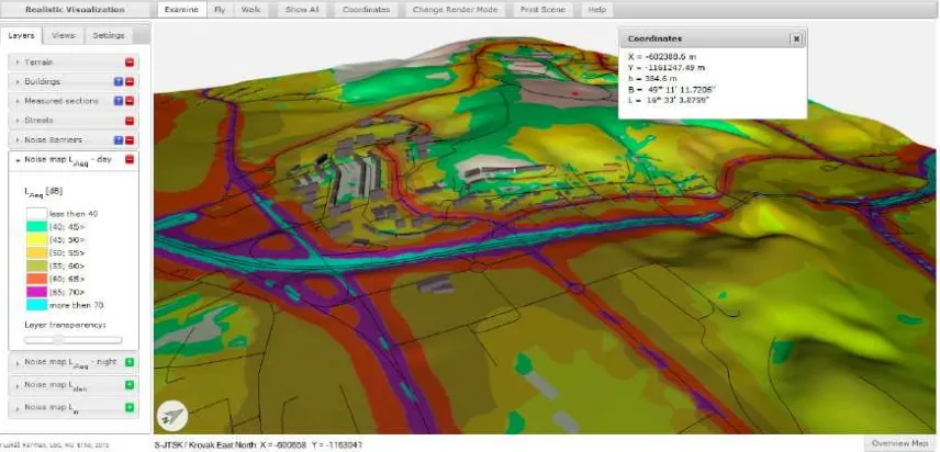
3D visualization of noise mapping based on regulations in Europe have been achieved using the INSPIRE Building Model based on the OGC CityGML standard.10
Noise pollution is only one of many factors that can be used to describe a neighborhood. There is no open, consensus-derived international standard encoding for describing neighborhoods. What other characteristics besides noise level should such a standard describe? There is no open international standard encoding for communicating the characteristics of buildings in a neighborhood (though the INSPIRE Data Specification on Buildings described in Section 3.2 provides a model). What would be the costs and value of creating such standards and ensuring that they work together along with other open spatial standards so that information about neighborhoods and buildings could be easily shared and used in analyses of many kinds?
2.3 Smart City Applications
Smart City technologies enable a broad set of applications including:
Utilities - Smart Grid, Smart Water, etc.
Sanitation
Intelligent Buildings
Intelligent Transportation
Health
Public Safety and Security
Environmental Protection
Emergency Services
Education
Urban Planning
Open Data
Each of the SDOs listed in Annex A has a variation of this list of Smart City
Applications. Also commercial companies, including OGC member companies, have multi-faceted strategies for Smart Cities. For example, OGC members are developing smart city strategies11 as well as Smart City application stores.12
10http://link.springer.com/chapter/10.1007%2F978-3-642-41151-9_39 11
http://blog.hexagongeospatial.com/bringing-smart-cities-life-barcelona/
2.4 Smart City Enterprise framework
Smart Cities require deployment of interoperable information system components. The high-level enterprise view of Smart City Components is shown in Figure 2. The
components are organized in layers typical of an information system deployment.
Figure 2. Enterprise Components
The Layers in this enterprise component diagram are based on the approach defined by the ITU Focus Group on Smart Sustainable Cities (See Section A.1.1). The layers are also consistent with the approach used in China’s Smart City Pilots13.
Subsequent sections 3 Information Viewpoint and 4 Services Viewpoint, define details for implementing the enterprise components.
3.
Spatial Information and Smart Cities
3.1 Spatial information is pervasive and primary
When organized using the concepts of space and time, information about cities can be the basis for many powerful services, analytics and decision-making. This section provides the beginnings of an architecture for urban spatial "intelligence" based on open standards, such as CityGML.
Figure 3. Visualization of a CityGML Model (Source: Thomas Kolbe)
The urban environment must address multiple scales of spatial information.
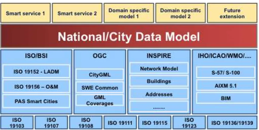
Figure 5 depicts some of the data model standards or encoding standards that make up the open information technology standards framework. Members of the OGC are actively involved in developing best practices for integrating these approaches. Such best practices will become part of the Smart Cities Spatial Information Framework.
Figure 5 Elements of a set of coordinated spatial information data standards and technology standards for use by Smart City information system architects (Source Carsten Rönsdorf)
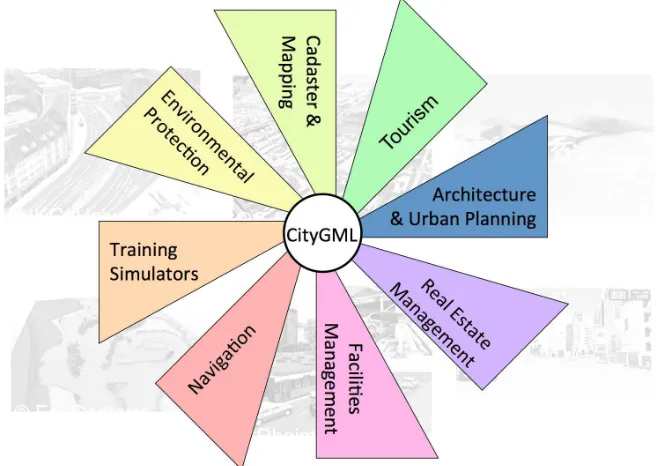
3.2 CityGML and IndoorGML
Smart cities require a framework of trusted/authoritative data; for example, core reference data in 2D and 3D (i.e. topography), identifiers and addressing, smart infrastructure (BIM, smart grid), and sensor feeds. Also critical is a Smart City's openness to data types, such as volunteered, unstructured14 and linked data15. Such a framework needs a robust data integration platform, which is provided, in part, by OGC City Geography Markup Language (CityGML).
With CityGML, spatial data become an “operating system” for a virtual version of a city. Practical use cases include things such as optimization of transport and efficient energy use. Berlin's city model enables a variety of improved city services including economic development/investment, real estate, city marketing and event management. For decades, cities have used GIS and geospatial data to improve various services and operations. A good example is London’s use of geospatial data for the 2012 Olympic and Paralympic Games to establish the route network and determine traffic impacts. Authorities in London also used geographic data to manage security operations and help direct building of needed infrastructure.
14
Smart cities require standards that enable data and apps to easily interoperate, but this requirement is often overlooked. A good way to begin is to develop a citywide 2D and 3D urban data model to integrate different sources of available geospatial data. The data model becomes the city's open standard, a language that all actors, datasets and
technologies use to interact.
Figure 6. CityGML as an integration platform (Source: Carsten Rönsdorf)
CityGML has been implemented in many cities including Berlin and Abu Dhabi, and it has been implemented countrywide in the Netherlands, Bahrain and Germany. CityGML enables semantic modeling, that is, each element in the model includes data about that element's meaning, structure and relationships.
The Berlin 3D City Model16 represents one of the world's largest municipal city models. It contains 560,000 fully textured building models in Level of Detail 2 (LoD2) and more than 200 detailed models in LoD3/4. The city model is the basis of the Berlin Economic Atlas and the Solar Atlas referenced earlier.
INSPIRE Data Specification on Buildings17 specifies a harmonized data
specification for the spatial data theme Buildings as defined in Annex III of the INSPIRE Directive [Directive 2007/2/EC]. The 3D representations of buildings are generally described using the well-defined levels of detail of the CityGML OGC standard. This INSPIRE specification is the basis of the visualization of noise mapping described earlier.
16
http://www.3dcitydb.net/3dcitydb/3dcitydb-in-action/
The national 3D standard in The Netherlands has been established using CityGML as described in OGC Best Practice: CityGML ADE - Dutch 3D standard (OGC document 12-066)18
Additional developments are underway using CityGML
o Finland national initiative to build up a nationwide 3D model o 3D National Data Model for Kingdom of Bahrain19
o Malaysian 3D SDI20 o 3D Singapore21
o CityGML and ARML applied to the I-35W Bridge Collapse22 o I-Scope Project23
o The City of Lyon, France is distributing city model in CityGML24
The OGC IndoorGML Encoding Standard specifies an open abstract data model and XML schema for indoor spatial information, specifically for modeling indoor spaces for navigation purposes. IndoorGML is designed to work with CityGML.
IndoorGML provides an open standard that supports easy discovery, assessment, access and use of data for applications that enable, for example, indoor location-based services, indoor route analysis, indoor geo-tagging services, and emergency control in indoor space. Requirements for other types of applications including indoor facility management may be addressed in the next version of IndoorGML.
IndoorGML provides a framework to represent contained spaces (such as rooms and corridors) as cells. Connections between spaces and constraints on movement between spaces (such as doors) are represented as relationships between cells. This OGC Standard defines the following information about indoor space:
Navigation context and constraints
Space subdivisions and types of connectivity between spaces
Geometric and semantic properties of spaces and connectivity
Navigation networks (logical and metric) and their relationships
3.3 LandXML and InfraGML25
LandXML is a non-proprietary XML (eXtensible Mark-up Language) data file format
containing civil engineering and survey measurement data commonly used in the Land Development and Transportation Industries. The LandXML user community consists of over 650 organizations with 750 members in over 40 countries and the standard is supported by over 70 registered software products.
The OGC Land and Infrastructure Domain Working Group is developing a new candidate standard – the OGC InfraGML Encoding Standard. This candidate standard provides a use
case driven subset of LandXML26 functionality, but that is implemented with the OGC
Geography Markup Language (GML) and supported by a UML (Unified Modeling
Language) conceptual model. InfraGML. The LandInfraDWG was chartered in 2013 to “focus is being designed to make it easy to use CAD-based land information with other OGC standards.” Both the land and infrastructure user domain and the geospatial technology user domain would benefit from integrated access to the two types of information.
One of the initial goals of the LandInfraDWG was to gain a better understanding of exactly what LandXML is and does. LandXML-1.2 contains almost 5000 lines of minimally documented XML code covering some 16 subject areas. There is no formally published documentation, user guide, requirements definition, or underlying conceptual model.
The Land and Infrastructure Standards Working Group (LandInfraSWG) was therefore
chartered. Its first task was to develop a UML as-is conceptual model of LandXML-1.2 to:
Q Aid in the understanding of what LandXML 1.2 is and does
Q Provide the basis for a conceptual model of what a future Land standard should do,
based on an assessment of user requirements
Q Establish a single set of consistent concepts that could be implemented in any set of
potential implementation-specific standards, such as a LandXML 2.0, a LandGML, a LandSQL, etc.
This reverse engineering of a LandXML conceptual model revealed a number of problems with LandXML as well as broad disparity with the OGC standards baseline. These findings
are summarized in the working groups’ November 5, 2013 “InfraGML Proposal (OGC
Document 13-121r1)” plan of action.
Fixing LandXML and extending it to support new technologies would result in a non-backwards compatible version. Consequently, the LandInfraSWG decided to embark upon the development of the new InfraGML standard. Initial subject areas will include
alignments, road, survey, terrain, and land parcels. Use cases have been documented for these subject areas. A draft UML conceptual model is almost complete and is being readied for public comment by the end of 2014. GML encoding is scheduled to begin early next year.
25http://www.opengeospatial.org/blog/2098
26 LandXML is a non-proprietary XML (eXtensible Mark-up Language) data file format containing civil
3.4 Building Information Models
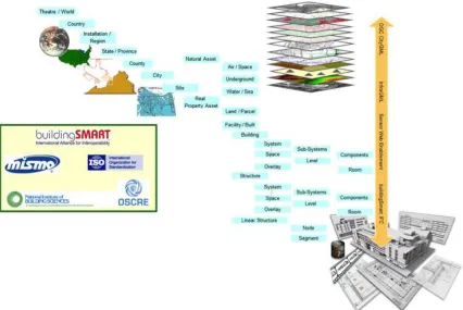
OGC is working with other standards development organizations (SDOs) to converge Building Information Model (BIM), 3D and Geospatial standards27. ISO/TC 59 Buildings and civil engineering works28, buildingSMART29, and the OGC are
coordinating for the development of standards as a foundation for the convergence of building and civil engineering design and geospatial technology. Other relevant SDOs include the Mortgage Industry Standards Maintenance Organization (MISMO)30, the National Institute of Building Sciences (NIBS)31 and OSCRE International32.
Figure 7. Seamless spatial data modeling across multiple SDOs
27
http://spatialnews.geocomm.com/dailynews/2014/nov/03/news2.html
28 http://www.iso.org/iso/iso_technical_committee?commid=49070 29http://www.buildingsmart.org/
30http://www.mismo.org 31
4.
Interoperability Services for Smart Cities
4.1 Geospatial Services Architecture
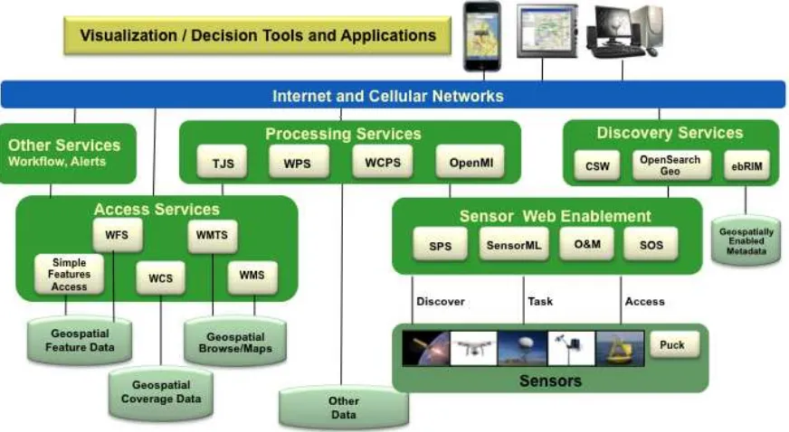
Access and processing of geospatial information for smart cities is achieved in a service-oriented architecture using open standards as shown in Figure 8. The OGC services are grouped in the figure and discussed in the following sections.
Figure 8. OGC Services Architecture for interoperable access and processing of geospatial information for decision support.
4.2 Sensor Web Enablement and SensorThings
The OGC's Sensor Web Enablement (SWE) standards enable developers to make all types of sensors, transducers and sensor data repositories discoverable, accessible and useable via the Web33.
The OGC SWE standards are:
Observations & Measurements (O&M) –The general models and XML encodings
for observations and measurements.
Sensor Model Language (SensorML) – Standard models and XML Schema for
describing the processes within sensor and observation processing systems.
Sensor Observation Service (SOS) – Open interface for a web service to obtain
observations and sensor and platform descriptions from one or more sensors.
Sensor Planning Service (SPS) – An open interface for a web service by which a client can 1) determine the feasibility of collecting data from one or more sensors or models and 2) submit collection requests.
PUCK Protocol Standard – Defines a protocol to retrieve a SensorML description,
sensor "driver" code, and other information from the device itself, thus enabling automatic sensor installation, configuration and operation.
SWE Common Data Model – Defines low-level data models for exchanging
sensor related data between nodes of the OGC® Sensor Web Enablement (SWE) framework.
SWE Service Model – Defines data types for common use across OGC Sensor
Web Enablement (SWE) services. Five of these packages define operation request and response types.
The OGC Sensor Web Enablement (SWE) SensorThings API candidate standard, now in draft will be an important standard for IoT. It builds on the OGC's comprehensive SWE standards suite, but it is designed to be lightweight and easily implemented. It
incorporates a REST-like API and JSON encoding, supports standards-based location encodings (indoor/outdoor, mobile/stationary), is linked data ready (JSON-LD), and is Pub-Sub ready (MQTT).
4.3 Data Access Services
The Access Services include the WFS and WCS Standards.
The OGC Web Feature Service (WFS)34 standard, also published as ISO 19142, allows a client to retrieve and update geospatial data encoded in Geography Markup Language (GML) and other encoding formats. WFS define interfaces for data access and
manipulation operations on geographic features. Via these interfaces, a user client can combine, use and manage geodata from different sources. Open standards for encoding feature data include GML, JSON, and KML.
The OGC Web Coverage Service (WCS)35standard supports electronic retrieval of geospatial data as "coverages" – that is, digital geospatial information representing space/time-varying phenomena. WCS provides access to coverage data in forms that are useful for client-side rendering, as input into scientific models, and for other clients. Open standards for encoding coverage data include NetCDF, HDF, GRIB, BUFR and GeoTIFF.
4.4 Processing Services
The OGC Web Processing Service (WPS)36 Interface Standard provides rules for standardizing how inputs and outputs (requests and responses) for geospatial processing services, such as polygon overlay. The standard also defines how a client can request the
34 http://www.opengeospatial.org/standards/wfs 35
http://www.opengeospatial.org/standards/wcs
execution of a process, and how the output from the process is handled. It defines an interface that facilitates the publishing of geospatial processes and clients’ discovery of and binding to those processes. The data required by the WPS can be delivered across a network or they can be available at the server.
The OGC Table Joining Service (TJS)37 offers a way to expose this corporate data to other computers, so that it can be found and accessed, and a way to merge that data with the spatial data that describes the framework, in order to enable mapping or geospatial analysis.
4.5 Catalogue Services
Catalogue services (also sometimes called registry services) provide interfaces to
discover, browse, and query metadata about data, services, and other potential resources. The OGC Catalogue Service for the Web (CSW) is a binding defined in the OpenGIS Catalogue Services Implementation Standard (CAT)38. (An OGC OpenSearch Geo standard is nearing adoption as OGC standard and is applicable as well.)
4.6 Workflow
Several SDOs define workflow standards that have been used by OGC. Often spatial processing will require several steps. The combination of workflows services and the OGC WPS provide a robust architecture for geospatial information processing.
The OGC Geoprocessing Workflow Architecture Engineering Report39 provides a
summary of Geoprocessing Workflow practices and methods that have been implemented in a services architecture using OGC services.
4.7 Context Document and GeoPackage
An OGC Web Services Context Document (OWS Context)40 can be used to organize a set of spatial information about a given topic and location. The Context document is share with user clients that open the OWS Context, retrieve the information, e.g., map layers and display the information.
This OGC GeoPackage Standard41 defines SQLite Extensions for direct use of vector geospatial features and / or tile matrix sets of earth images and raster maps at various scales. GeoPackages are interoperable across all enterprise and personal computing environments, and are particularly useful on mobile devices like cell phones and tablets in communications environments with limited connectivity and bandwidth.
4.8 Visualization and Augmented Reality
The OGC has adopted standards that support visualization of geographic information. These standards allow applications to separate portrayal functions from processing functions in a single device or in distributed environments. For example:
The OGC Web Map Service (WMS) Interface Standard provides a simple HTTP
interface for requesting geo-registered map images from one or more distributed geospatial databases. The images are returned in specified format such as TIF or JPEG.
The OGC Web Map Tile Service (WMTS) standard provides for serving spatially
referenced tile images with predefined content, extent, and resolution. WMTS trades the flexibility of custom map rendering – as provided by WMS – for the scalability possible by serving a fixed set of tiles.
The OGC Symbology Encoding Standard is an XML language for styling
information and related symbology rules. OGC SLD allows Different cartographic styles to be applied to the same data, enabling delivery of different map styles for different user populations, such as assessors and first responders.
OGC KML is an XML language focused on geographic visualization, including annotation of maps and images. Geographic visualization includes not only the presentation of graphical data on the globe, but also the control of the user's navigation in the sense of where to go and where to look.
The OGC ARML 2.0 candidate standard provides an interchange format for
Augmented Reality (AR) applications to describe and interact with objects in an AR scene, with a focus on mobile, vision-based AR.
3D portrayal standards are being finalized by an OGC Standards Working Group42. The group is to progress the Candidate Web 3D Service Interface Standard and the Web View Service Discussion Paper to the state of an integrated, adopted OGC standard. The SWG will achieve this objective by processing the comments submitted during the public comment period and ensuring that the candidate standard is consistent with the OGC baseline and business plan.
The 3D Portrayal SWG builds on the success of the OGC 3D Portrayal Interoperability Experiment (3DPIE)43 The 3DPIE report contains technical details on processing 3D information in an OGC service environment as well as best practices on how to portray large data sets in urban planning scenarios, taking into account architectures and capabilities of interactive 3D graphics. Especially Web 3D Service and Web View Service, two draft standards (published as OGC discussions paper), have been in the focus of 3DPIE.
A demonstration at Mobile World Congress 2014 of three major AR browsers showed the vision of interoperable AR.44
42http://www.opengeospatial.org/projects/groups/3dpswg 43
https://portal.opengeospatial.org/files/?artifact_id=49068
5.
Development of Spatial Information Framework for Smart Cities
5.1 Spatial Information Architecture for Smart Cities
This white paper is one step in a process of applying open standards to the spatial information vital to Smart Cities. This white paper will be considered by the OGC membership with discussion of next steps. Possible next steps include for the OGC Standards Program
Discussion of Spatial Information Framework for Smart Cities with several OGC Working Groups including the Urban Planning DWG and the 3D Information Management DWG.
Development of an OGC Best Practice for Smart Cities. This white paper serves as input to such a best practice.
Identification and development of profiles of OGC standards needed for Smart Cities.
Coordination with other SDOs about standards that work together to provide an operational set of standards for Smart Cities. The SDOs identified in Annex A are candidates for such coordination.
The Location Powers Smart City Summit was held on 2 December 2014 in Tokyo45. The Summit focused on understanding the location and place needs of a Smart City.
Participants tested assumptions of what a Smart City is, explored the role of the citizen, looked at the fundamental infrastructure, and looked at how we “see” a Smart City and understand a Smart City. This white paper benefited from the discussion at the Summit.
5.2 OGC Smart City Interoperability Initiatives – Testbeds, Pilots etc.
The OGC Interoperability Program provides an agile, rapid engineering environment to accelerate development and testing of standards based on real world use cases. Candidate information exchange standards are developed at the same time that OGC vendor
members are developing prototype software solutions. The OGC has conducted more than 80 of these international multi-firm R&D experiments in the last 15 years, each based on user-supplied scenarios. OGC testbeds have repeatedly demonstrated success at transitioning research into operations based on open standards.
The OGC Interoperability Program is carrying out a strategy for Smart Cities. Activities relevant to Smart Cities are currently underway in OGC Testbed 11 and the CityGML Quality Interoperability Experiment. Pilots for specific cities are in the planning stages. The pilots will carryout the deployments described in the next section and additional activities.
5.3 Deploying the Spatial Information Framework for Smart Cities
5.3.1 Building a City Model
Building a model of the urban environment using OGC CityGML is a first step for many of the deployments described below. Having a CityGML representation of a city is the modern day equivalent of having a 2D map. Having a 3D, semantically enabled information model of the city enables many functions.
Building a CityGML model has been done in many cities. OGC is currently preparing a report – “Rapid model-building for venue owners” – on the steps and costs associated with building a CityGML model from multiple information sources.
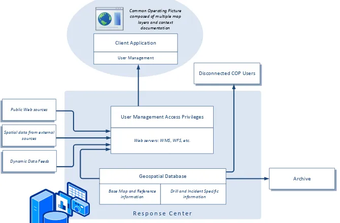
5.3.2 Common Operating Picture
Accurate, timely, and georeferenced information is vital to operational and strategic decision-making. The incompatibility of proprietary databases and software used by the in previous emergencies has been a hindrance. Based on lessons learned, government agencies are requiring the private sector to support open standards based approaches in particular for creating a Common Operating Picture (COP) for emergency response.
Working with government and industry, OGC has led development of a COP
Architecture for emergencies. Figure 9 provides the recommended services architecture for a COP based on Web Services. This COP architecture has been applied in multiple OGC initiatives for emergencies located in urban areas. Figure 9 identifies services and interfaces based on best practices and open standards. This architecture is based on operational and development systems that deliver a COP for oil spill response using open standards. Packaging the services into components is addressed in the Deployment Viewpoint section of this document.
R e s p o n s e C e n t e r
5.3.3 Recreation indicator: Outdoor recreation space
Calculation of area for urban spaces is a mature GIS-based capability. Key to best use of urban space is to have a richer semantic understanding of these spaces. Also it’s
important that both indoor and outdoor spaces are counted in the semantic bucket of interest.
“Square meters of public outdoor recreation space per capita” is indicator 13.2 in the Recreation category of ISO 37120. Calculating this indicator and related space
calculations is easy using a CityGML model. Additional studies can be accomplished, e.g., some indoor spaces would provide the same benefits as outdoor public spaces. Calculation of the area can be done from any open-standards client requesting a query to WFS-equipped database holding the CityGML model and/or could be calculated by request to a WPS that performs the algorithm.
Additionally studies of spatial "flows" are important in understanding recreation space. Two additional OGC standards are relevant to spatial flows.
The OGC IndoorGML standard is for navigation and routing of indoor spaces. Knowing the available spatial flows for indoor mobility in different modes is key to such a study.
The OGC Moving Features standard captures the movement of pedestrian and vehicles through spaces. The advance of mobile computing and internet-connected sensors (including sensors and GPS transponders in cell phones and notebook computers) brings with it a rapid rise in applications for moving feature data.
Crowdsourcing of data about pedestrian and vehicle movement in urban environments is a great source for spatial flow studies to improve the quality and safety of urban living.
5.3.4 Energy indicator: Renewable energy sources
“The percentage of total energy derived from renewable sources, as a share of the city's total energy consumption” is indicator 7.4 in the Energy category of ISO 37120.
The Solar Atlas of Berlin46 is based on the Berlin CityGML model is an operational system based on open standards so that the approach can be easily set up in any city based on a CityGML model.
Open standards-based are the foundation for integrating BIM, geospatial and smart meters for urban energy performance optimization conducted by the European SUNSHINE project47
46http://www.businesslocationcenter.de/wab 47
5.3.5 Environment indicator: Noise pollution
“Noise Pollution” is indicator 8.7 in the Environment category of ISO/DIS 37120.
This indicator can be assessed using established methods based on OGC standards. 3D visualization of noise mapping based on regulations in Europe have been achieved using the INSPIRE Building Model based on the OGC CityGML standard.48
Figure 10. Web 3D visualization of noise mapping using OGC standards
5.3.6 Urban Economic Analysis
Urban economic modeling and effective spatial planning are critical tools towards achieving urban sustainability. However, in practice, many technical obstacles, such as information islands, poor documentation of data and lack of software platforms to facilitate virtual collaboration, are challenging the effectiveness of decision-making processes. Li et.al. reports49 on their efforts to design and develop a geospatial
cyberinfrastructure (GCI) for urban economic analysis and simulation. The urban GCI implements several OGC standards: WMS, WFS as well as WPS. The WPS is used in a chained flow of geoprocessing services to support effective spatial policy analysis and decision-making.
5.3.7 Analytics – Science of Cities
Analytics refers to the discovery and communication of meaningful patterns in data, particularly "big data." Big data refers to massive volumes of data that typically include both structured and unstructured data that are thus difficult to process using traditional database and software methods. In Smart Cities, processing of sensor feeds using big data analytics will be useful for many purposes.
48
http://www.isess2013.org/res/presentations/isess2013_paper74_herman.pdf
The new science of analytics is integral to a "New Science of Cities50
," the title of a book by Michael Batty. As stated on the publisher's web page for the book:
"In The New Science of Cities, Michael Batty suggests that to understand cities we must view them not simply as places in space but as systems of networks and flows. To understand space, he argues, we must understand flows, and to understand flows, we must understand networks—the relations between objects that comprise the system of the city. Drawing on the complexity sciences, social physics, urban economics, transportation theory, regional science, and urban geography, and building on his own previous work, Batty introduces theories and methods that reveal the deep structure of how cities function.
Use of WPS to “wrap” cloud computing has been successful for big data analytics and is directly applicable to the analytics considered in the new science of cities.
5.3.8 Crowdsourcing
Crowdsourcing and Volunteered Geographic Information (VGI) can increase in accessibility by making the data open with open standards. Many of the existing
crowdsourcing applications are “stovepipes” from the sensor to the browser. Application of OGC standards is key to making this truly open data.
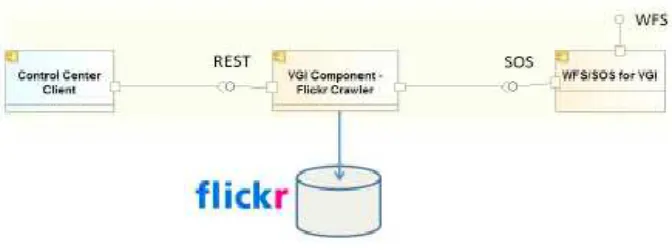
The concept of using a Web Feature Service in combination with a Sensor Observation Service (SOS) for handling human as sensors is has been accomplished in past OGC initiatives51. A developed data model for VGI for Sensor Web was presented and illustrated with examples from Twitter, Flickr and from mobile devices directly.
Figure 11. OGC testbed example of integrating Flickr with OGC Services
50The New Science of Cities, by Michael Batty, MIT Press, 2013,
http://mitpress.mit.edu/books/new-science-cities.
SensorThings extends the OGC Sensor Web Enablement standards to Internet of Things environment. SensorThings brings the robust semantics to this new emerging world of sensors truly everywhere.
Figure 12. Scope of SensorThings standards SWG
There are many great new projects providing deployed sensors in cities, e.g., AirCasting52 for noise and air quality and Array of Things53 for weather and air quality at a city block level of resolution. One approach is to work with these projects to make their data available through open interfaces and therefore accessible for the wider benefits of an Open Smart Cities approach.
5.3.9 Open Data for Smart Cities
Open Data is a key enabler for informed public and for informed city officials. Public ability to access and use data has grown with the growth of the Web. Spatial open data and open data from many cities is bringing new opportunities for people to assess the situation from their perspective and thereby provide better input to collective decision making.
OGC works with the open source geospatial promoters, e.g., OS Geo, LocationTech, Apache, etc. Open data from for example, Open Street Map and Location Tech provide data that have been a boon to systems based on open standard services from OGC.
52
http://aircasting.org/
Annex A. Open Standards Coordination for Smart Cities
54A.1 OGC coordination with other Standards Developing Organizations
This section provides a brief review of recent Smart City Standards activities by other Standards Development Organizations (SDOs).
Because the need for spatial communication arises in so many different IT contexts, the standards development work of the OGC cannot happen in a geospatial technology silo separated from the larger world of information technology (IT). Therefore, the OGC makes significant efforts to liaise and collaborate with other SDOs. This kind of collaboration is critical in establishing a Smart Cities Spatial Information Framework.
Since 1994, the OGC has maintained a close relationship with ISO/TC 211 (Geographic Information/Geomatics). Standards from the ISO 19100 series comprise significant topics of the OGC Abstract Specification. Further, the OGC standards WMS, GML, WFS, FE, O&M, and Simple Features. OGC's submission of its standards to ISO in a formal process for ISO adoption helps many organizations meet policy requirements or preference for de jure international standards.
Figure 13. Where the OGC fits in the standards world
In the years since then, the OGC has developed formal relationships with other standards organizations, with the details of cooperation often codified in memoranda of
understanding. OGC works with other SDO’s to help standardize the representation, processing and exchange of geospatial/location information in a consistent manner throughout the standards community.
54
A.2 International Standards activities on Smart Cities
A.2.1 ITU Focus Group on Smart Sustainable Cities
The ITU established a Focus Group on Smart Sustainable Cities (FG-SSC),55 which created a dozen documents.
The FG-SSC Roadmap for Smart Sustainable Cities (SSC) Implementation identified the Key attributes of an SSC, most notably: a) Sustainability, b) Quality of Life, c)
Intelligence or Smartness.
The FG-SSC TR on Standardization Activities and Gaps for SSC was the Source of the Figure that is reused in JTC 1/SC 1 Report on standardization needs for Smart Cities56
Figure 14. The FG-SSC TR on Smart Sustainable Cities Infrastructure created this figure describing the Technical Architecture of a SSC.
A.2.2 ISO/IEC JTC 1 Study Group 1 on Smart Cities
ISO/IEC JTC 1 created a Study Group to review Smart City topics. The Study Group was a short-term group that has now completed its report. The report is posted for the
55
http://www.itu.int/en/ITU-T/focusgroups/ssc/Pages/default.aspx
JTC 1 Plenary that will occur in November 2014. One recommendation by the SG 1 is to create a new JTC 1 Special Working Group to continue the work. Figure 15 from the JTC 1 report shows potential relationships for SDO coordination on Smart City Standards model. The JTC 1 SG 1 Smart Cities report includes these spatial items:
6.4.3 Facilitating Instrumentation, Analysis, Decision-Making, and Automation
Geospatial Information
7.5 GIS (Geographic Information System). Note the “GIS” database in the figure.
The JTC 1 report defines a Framework for Modeling Smart Cities based on RM-ODP.
Figure 15. Smart City Standards model. The figure was initially developed by ITU FG-SSC. The ellipses were added by JTC 1 to approximately represent the core areas of ISO (red), ISO/IEC
A.2.3 ISO Technical Management Board Task Force on Smart Cities
The ISO Technical Management Board (TMB) established a Task Force on Smart Cities. A report was complete for the TMB meeting in February 2014. Based on the report, the TMB created an Advisory Group on Smart Cities - to be led by the British Standards Institute (BSI).
The ISO TMB Advisory Group (TAG) on Smart Cities now underway was directed to deliver its final report to the TMB's September 2015 meeting. There was a TAG Smart Cities meeting during the Barcelona Smart Cities Expo in November 2014.
A.2.4 ISO ISO/TC 268 - Sustainable development and resilience of communities
The ISO TC 268 has developed these standards relevant to Smart Cities
ISO 37120 Sustainable development and resilience of communities — Indicators for city services and quality of life
ISO 37101 – Management Systems
ISO 37120 – Indicators for city services
ISO 37150 & ISO 37151 – smart infrastructure
Example indicators from ISO/DIS 37120 were provided in an earlier section.
A.3 National Standards Activities
A.3.1 British Standards Institute
The British Standards Institute (BSI)57 has published two Publicly Available Specification (PAS) documents on Smart City Framework (SCF):
- PAS 180 - Smart Cities Vocabulary
- PAS 181 – Smart city framework – Guide to establishing strategies for Smart Cities and communities
- PAS 182, Smart city concept model
BSI PAS 180 defines a Smart City as an effective integration of physical, digital and human systems in the built environment to deliver a sustainable, prosperous and inclusive future for its citizens.
PAS 181 defines a dozen Guidance Notes. These three are particularly very relevant for location:
- Transforming the City’s Operating Model re Information - Empowering Stakeholder-led Service Transformation - Mapping the City’s Interoperability Needs
PAS 181 also advocates using a SCF “pattern language” approach based on Christopher Alexander’s approach.
PAS 182, Smart city concept model is a guide to establishing a model for data interoperability, which will provide a framework that can normalize and classify
information from many sources so that data sets can be discovered and combined to gain a better picture of the needs and behaviors of a city’s citizens (residents and businesses).
A.3.2 DKE/DIN Smart City Standardization Roadmap
DKE/DIN58 published The German Standardization Roadmap Smart City, Version 1. The document provides a general outline as shown in Figure __ below.
Figure 16. DKE/DIN Smart City Standardization Roadmap
58 German Commission for Electrical, Electronic & Information Technologies of DIN and VDE. (DIN is
A.4 Others organizations' standards activities
Multiple other Standards Developing Organizations have Smart City Activities:
IEC Systems Evaluation Group - Smart Cities
http://www.iec.ch/dyn/www/f?p=103:186:0::::FSP_ORG_ID,FSP_LANG_ID:10330,25
ANSI Network on Smart and Sustainable Cities (ANSSC)
http://www.ansi.org/standards_activities/standards_boards_panels/anssc/overview.aspx?menuid=3 CEN/CENELEC
http://www.cencenelec.eu/standards/Sectors/SmartLiving/smartcities/Pages/default.aspx
ETSI (ETSI - European Telecommunications Standards Institute)
IEEE has a Smart Cities website (http://smartcities.ieee.org/) providing
information and news about IEEE events in targeted cities that feature experts in specific areas of focus.
Many other organizations that are not SDOs have programs that focus on Smart Cities, such as the NIST Global Cities Challenge59, Brookings Institute60 and the Smart Cities Council. The OGC is on the Advisory Board of the Smart Cities Council and contributed to the Smart Cities Readiness Guide61.
59http://www.nist.gov/cps/sagc.cfm 60