Open Geospatial Consortium
Publication Date: 2014-02-04
Approval Date: 2013-12-10
Submission Date: 2012-11-05
Reference number of this OGC® document: OGC 12-000
OGC name of this OGC® project document: http://www.opengis.net/doc/IS/SensorML/2.0
Version:2.0.0
Category: OGC® Encoding Standard
Editor: Mike Botts Co-Editor: Alexandre Robin
OGC
®SensorML:
Model and XML Encoding Standard
Copyright notice
Copyright © 2014 Open Geospatial Consortium
To obtain additional rights of use, visit http://www.opengeospatial.org/legal/.
Warning
This document is an OGC Member approved international standard. This document is available on a royalty free, non-discriminatory basis. Recipients of this document are invited to submit, with their comments, notification of any relevant patent rights of which they are aware and to provide supporting documentation.
Document type: OGC® Publicly Available Standard Document subtype: Encoding
OGC 12-000 SensorML
Copyright © 2014 Open Geospatial Consortium
ii
License Agreement
Permission is hereby granted by the Open Geospatial Consortium, ("Licensor"), free of charge and subject to the terms set forth below, to any person obtaining a copy of this Intellectual Property and any associated documentation, to deal in the Intellectual Property without restriction (except as set forth below), including without limitation the rights to implement, use, copy, modify, merge, publish, distribute, and/or sublicense copies of the Intellectual Property, and to permit persons to whom the Intellectual Property is furnished to do so, provided that all copyright notices on the intellectual property are retained intact and that each person to whom the Intellectual Property is furnished agrees to the terms of this Agreement.
If you modify the Intellectual Property, all copies of the modified Intellectual Property must include, in addition to the above copyright notice, a notice that the Intellectual Property includes modifications that have not been approved or adopted by LICENSOR. THIS LICENSE IS A COPYRIGHT LICENSE ONLY, AND DOES NOT CONVEY ANY RIGHTS UNDER ANY PATENTS THAT MAY BE IN FORCE ANYWHERE IN THE WORLD.
THE INTELLECTUAL PROPERTY IS PROVIDED "AS IS", WITHOUT WARRANTY OF ANY KIND, EXPRESS OR IMPLIED, INCLUDING BUT NOT LIMITED TO THE WARRANTIES OF MERCHANTABILITY, FITNESS FOR A PARTICULAR PURPOSE, AND NONINFRINGEMENT OF THIRD PARTY RIGHTS. THE COPYRIGHT HOLDER OR HOLDERS INCLUDED IN THIS NOTICE DO NOT WARRANT THAT THE FUNCTIONS CONTAINED IN THE INTELLECTUAL PROPERTY WILL MEET YOUR REQUIREMENTS OR THAT THE OPERATION OF THE INTELLECTUAL PROPERTY WILL BE UNINTERRUPTED OR ERROR FREE. ANY USE OF THE INTELLECTUAL PROPERTY SHALL BE MADE ENTIRELY AT THE USER’S OWN RISK. IN NO EVENT SHALL THE COPYRIGHT HOLDER OR ANY CONTRIBUTOR OF INTELLECTUAL PROPERTY RIGHTS TO THE INTELLECTUAL PROPERTY BE LIABLE FOR ANY CLAIM, OR ANY DIRECT, SPECIAL, INDIRECT OR CONSEQUENTIAL DAMAGES, OR ANY DAMAGES WHATSOEVER RESULTING FROM ANY ALLEGED INFRINGEMENT OR ANY LOSS OF USE, DATA OR PROFITS, WHETHER IN AN ACTION OF CONTRACT, NEGLIGENCE OR UNDER ANY OTHER LEGAL THEORY, ARISING OUT OF OR IN CONNECTION WITH THE IMPLEMENTATION, USE, COMMERCIALIZATION OR PERFORMANCE OF THIS INTELLECTUAL PROPERTY. This license is effective until terminated. You may terminate it at any time by destroying the Intellectual Property together with all copies in any form. The license will also terminate if you fail to comply with any term or condition of this Agreement. Except as provided in the following sentence, no such termination of this license shall require the termination of any third party end-user sublicense to the Intellectual Property which is in force as of the date of notice of such termination. In addition, should the Intellectual Property, or the operation of the Intellectual Property, infringe, or in LICENSOR’s sole opinion be likely to infringe, any patent, copyright, trademark or other right of a third party, you agree that LICENSOR, in its sole discretion, may terminate this license without any compensation or liability to you, your licensees or any other party. You agree upon termination of any kind to destroy or cause to be destroyed the Intellectual Property together with all copies in any form, whether held by you or by any third party. Except as contained in this notice, the name of LICENSOR or of any other holder of a copyright in all or part of the Intellectual Property shall not be used in advertising or otherwise to promote the sale, use or other dealings in this Intellectual Property without prior written authorization of LICENSOR or such copyright holder. LICENSOR is and shall at all times be the sole entity that may authorize you or any third party to use certification marks, trademarks or other special designations to indicate compliance with any LICENSOR standards or specifications.
Copyright © 2014 Open Geospatial Consortium iii
Contents
i. Abstract ... ix
ii. Keywords ... ix
iii. Submitting Organizations ... ix
Submission Contact Points ... x
iv. Future Work ... x
v. Changes to the OGC® Abstract Specification ... x
Sensor Model Language (SensorML): An Implementation Standard ... 14
1 Scope ... 14
2 Conformance ... 16
2.1 Overview ... 16
2.2 Specification identifier ... 16
2.3 Conformance classes ... 16
3 Normative References ... 18
4 Terms and Definitions ... 19
5 Conventions ... 23
5.1 Abbreviated terms ... 23
5.2 UML notation ... 23
5.3 Table notation used to express requirements ... 24
6 Requirements Class: Core Concepts (normative core) ... 26
6.1 Introduction ... 26
6.2 Process Definitions ... 27
7 UML Conceptual Models (normative) ... 29
7.1 Package Dependencies ... 29
7.1.1 Dependency on GML Feature Model and ISO TC 211 Models ... 29
7.1.2 Dependency on SWE Common Data Models ... 32
7.1.3 Relationship to Observations and Measurements (O&M) ... 34
7.2 Requirements Class: Core Abstract Process ... 36
7.2.1 ObservableProperty ... 36
7.2.2 DescribedObject ... 37
7.2.3 AbstractProcess ... 43
7.2.4 SWE Common Data Types ... 49
7.3 Requirements Class: Simple Process ... 50
OGC 12-000 SensorML
Copyright © 2014 Open Geospatial Consortium
iv
7.3.2 Process Method Definition ... 52
7.4 Requirements Class: Aggregate Process ... 53
7.4.1 Aggregate Process Definition ... 53
7.6 Requirement Class: Physical Component ... 56
7.6.1 Abstract Physical Process Defined ... 56
7.6.2 Physical Component Defined ... 61
7.7 Requirement Class: Physical System ... 62
7.8 Requirements Class: Processes with Advanced Data Types ... 65
7.9 Requirements Class: Configurable Processes ... 66
7.9.1 Modes ... 67
7.9.2 Settings ... 68
8 XML Schema Implementation (normative) ... 71
8.1 Requirements Class: Core Abstract Process Schema ... 72
8.1.1 General XML Principles ... 72
8.1.2 General XSD Dependencies and XML Heading ... 75
8.1.3 DescribedObject Properties ... 78
8.1.4 Abstract Process ... 96
8.2 Requirements Class: Simple Process Schema ... 115
8.2.1 Simple Process ... 115
8.2.2 Process Method ... 116
8.3 Requirements Class: Aggregate Process Schema ... 118
8.3.1 Aggregate Process ... 119
8.3.2 Components ... 125
8.3.3 Connections ... 127
8.4 Requirements Class: Physical Component Schema ... 131
8.4.1 Abstract Physical Process ... 131
8.4.2 Physical Component ... 144
8.5 Requirements Class: Physical System Schema ... 147
8.5.1 Physical System ... 147
Requirements Class: Configurable Process Schema ... 152
8.5.2 Modes ... 152
8.5.3 Settings ... 155
A.1 Conformance Test Class: Core Concepts ... 158
A.1.1 Core concepts are the base of all derived models ... 158
A.1.2 A process model has inputs, outputs, parameters, and method ... 158
Copyright © 2014 Open Geospatial Consortium v
A.1.4 A process model has metadata ... 159
A.1.5 Metadata not used in process execution ... 159
A.2 Conformance Test Class: Core Abstract Process ... 160
A.2.1 Dependency on Core ... 160
A.2.2 Fully implement CoreProcess ... 160
A.2.3 DescribedObject derived from GML AbstractFeature ... 161
A.2.4 Using GML identifier for uniqueID in CoreProcess ... 161
A.2.5 Extensions shall be in a separate namespace ... 161
A.2.6 Extensions shall not be required for process execution ... 162
A.2.7 ObservableProperty and SWE Common Data used for process input, output, and parameters ... 162
A.2.8 Use of SWE Common Data aggregate models for process input, output, and parameters ... 162
A.2.9 Application and requirements of typeOf property ... 163
A.2.10 Simple inheritance extends a base class referenced by typeOf ... 163
A.2.11 Supporting configuration in processes ... 163
A.2.12 Dependency on SWE Common Data simple types ... 163
A.3 Conformance Test Class: Simple Process ... 165
A.3.1 Dependency on core ... 165
A.3.2 Fully Implement SimpleProcess ... 165
A.3.3 Simple process definition ... 166
A.3.4 Simple process has method ... 166
A.4 Conformance Test Class: Aggregate Process ... 167
A.4.1 Dependency on core ... 167
A.4.2 Fully Implement Aggregate Process ... 167
A.4.3 Definition of Aggregate Process ... 168
A.4.4 Aggregate Process requires one or more components ... 168
A.5 Conformance Test Class: Physical Component ... 169
A.5.1 Fully implement Physical Component ... 169
A.5.2 Dependency on core process ... 169
A.5.3 Position by point ... 170
A.5.4 Position by location and orientation ... 170
A.5.5 Position by trajectory ... 170
A.5.6 Position by process ... 171
A.5.7 Physical Component definition ... 171
A.6 Conformance Test Class: Physical System ... 172
OGC 12-000 SensorML
Copyright © 2014 Open Geospatial Consortium
vi
A.6.2 Physical System definition ... 172
A.6.3 Physical System dependency ... 173
A.7 Conformance Test Class: Process with Advanced Data Types ... 174
A.7.1 Advanced Process dependency ... 174
A.7.2 Fully implement AdvancedProcess ... 174
A.8 Conformance Test Class: Configurable Processes ... 175
A.8.1 Dependency on Core Process ... 175
A.8.2 Fully Implement Configurable Process ... 175
A.8.3 ModeChoice requires 2 or more Modes ... 175
A.8.4 A configured process requires a Settings element ... 176
A.8.5 Only parameter values can be set by setValue ... 176
A.8.6 Only parameter array values can be set by setArrayValues ... 176
A.8.7 Only parameter values can be constrained with setConstraint ... 177
B.1 Conformance Test Class: Core Abstract Process Schema ... 178
B.1.1 Compliance with core XML schemas and Schematron patterns ... 178
B.1.2 XML property values are included inline or by reference ... 179
B.1.3 Each extension uses a different namespace ... 179
B.1.4 Extensions do not redefine XML elements or types ... 179
B.1.5 The value of the definition attribute is a resolvable URI ... 180
B.1.6 Dependence on GML 3.2 ... 180
B.1.7 Dependence on SWE Common Data 2.0 ... 180
B.1.8 Globally unique ID required ... 180
B.1.9 External namespace required for security constraints ... 181
B.1.10 Extension element used for security tagging of individual properties ... 181
B.1.11 Xlink role or arcrole shall be used to define relationship of contacts ... 181
B.1.12 The typeOf property shall provide the uniqueID and resolvable location of the description on the referenced object ... 182
B.1.13 The feature of interest property shall specify a role, and if available, the uniqueID of the feature ... 182
B.1.14 The definition attribute required for ObservableProperty ... 182
B.1.15 Use aggregate data for related data elements ... 183
B.1.16 Use Vector for inputs, outputs, and parameters that specify position ... 183
B.1.17 Use of resolvable URL to reference data streams ... 183
B.1.18 Use DataChoice in multiplexed data streams ... 184
B.2 Conformance Test Class: Simple Process Schema ... 185
Copyright © 2014 Open Geospatial Consortium vii
B.3 Conformance Test Class: Aggregate Process Schema ... 186
B.3.1 Compliance with simple_process XML schemas and Schematron patterns ... 186
B.3.2 Title and resolvable URL required for components provided by Reference ... 186
B.4 Conformance Test Class: Physical Component Schema ... 189
B.4.1 Compliance with physical_component XML schemas and Schematron patterns ... 189
B.4.2 A physical process can only attach to a physical process ... 189
B.4.3 The attachedTo element shall have xlink:title and xlink:href ... 190
B.4.4 Position requires a DataRecord with two Vectors ... 190
B.4.5 Dynamic state requires a Data Array or Process ... 190
B.4.6 Trajectory requires a DataArray with a time field and one or more Vectors ... 191
B.4.7 Process required for positions or state provided on-demand ... 191
B.5 Conformance Test Class: Physical System Schema ... 192
B.5.1 Compliance with physical_system XML schemas and Schematron patterns ... 192
B.6 Conformance Test Class: Configurable Process Schema ... 193
B.6.1 Compliance with configuration XML schemas and Schematron patterns ... 193
B.6.2 Modes can change values of parameters ... 193
OGC 12-000 SensorML
Copyright © 2014 Open Geospatial Consortium
viii
Table of Figures
Figure 5.1 – UML Notation ... 24
Figure 7.1 – Internal Package Dependencies ... 29
Figure 7.2 – External Package Dependencies – GML ... 30
Figure 7.3 – Models for dependent GML Feature classes ... 31
Figure 7.4 – External Package Dependencies – ISO TC 211 ... 31
Figure 7.5 – ISO 19115 Models for dependent classes. ... 32
Figure 7.6 – External Package Dependencies – SWE Common Data ... 33
Figure 7.7 –Models for dependent SWE Common AbstractDataComponent class. ... 34
Figure 7.8 – DescribedObject with Metadata Properties ... 39
Figure 7.9 – Models for Metadata Elements ... 39
Figure 7.10 – Model for history events ... 43
Figure 7.11 – UML models for DescribedObject and AbstractProcess ... 44
Figure 7.12 – UML models for process inputs, outputs, and parameters. ... 45
Figure 7.13 – Model for Simple Process ... 51
Figure 7.14 – Model for ProcessMethod ... 52
Figure 7.15 – Model for Aggregate Process ... 55
Figure 7.16 – Model for Physical Process Component ... 57
Figure 7.17 – Models for SpatialFrame and PositionUnion ... 59
Figure 7.18 – Model for Physical Processing System ... 63
Figure 7.19 – Model for Modes ... 68
Figure 7.20 – Model for Configured Process Settings ... 69
Copyright © 2014 Open Geospatial Consortium ix
i. Abstract
The primary focus of the Sensor Model Language (SensorML) is to provide a robust and semantically-tied means of defining processes and processing components associated with the measurement and post-measurement transformation of observations. This includes sensors and actuators as well as computational processes applied pre- and post-measurement.
The main objective is to enable interoperability, first at the syntactic level and later at the semantic level (by using ontologies and semantic mediation), so that sensors and processes can be better understood by machines, utilized automatically in complex workflows, and easily shared between intelligent sensor web nodes.
This standard is one of several implementation standards produced under OGC’s Sensor Web Enablement (SWE) activity. This standard is a revision of content that was previously integrated in the SensorML version 1.0 standard (OGC 07-000).
ii. Keywords
ogcdoc, sensor model language, sensorml, swe, sensors, actuators, detectors, transducers, processes, processing, observations, measurement, data quality, data lineage, data provenance
iii. Submitting Organizations
The following organizations have contributed and submitted this Encoding Standard to the Open Geospatial Consortium:
Botts Innovative Research, Inc.
Sensia Software LLC
Spot Image, S.A.
Seicorp, Inc.
US National Geospatial Intelligence Agency (NGA)
OGC 12-000 SensorML
Copyright © 2014 Open Geospatial Consortium
x
Submission Contact Points
All questions regarding this submission should be directed to the editor or the submitters:
Contact Company Email
Michael E. Botts Botts Innovative Research, Inc mike.botts<at>botts-inc.com
Alexandre Robin Sensia Software LLC alex.robin<at>sensiasoftware.com
Jim Greenwood Seicorp, Inc. jgreenwood<at>Seicorp.com
David Wesloh US National Geospatial Intelligence Agency
David.G.Wesloh<at>nga.mil
iv. Future Work
Future work will target the description of specialized processes, sensors, and actuators by restricting (via profiles) the generic models and schema defined in this standard. Such profiles will allow interoperability of models and schema both within specific processing and measurement communities as well as between disparate.
v. Changes to the OGC
®Abstract Specification
Copyright © 2014 Open Geospatial Consortium xi
Foreword
OGC 12-000 SensorML
Copyright © 2014 Open Geospatial Consortium
xii
Introduction
This standard originated from work originally undertaken through the Open Geospatial Consortium’s Sensor Web Enablement (SWE) activity. SWE is concerned with establishing interfaces and encodings that will enable a “Sensor Web” through which applications and services will be able to access sensors of all types, and observations generated by them, over the Web. SWE has defined, prototyped and tested several components needed for a Sensor Web, namely:
- Sensor Model Language (SensorML) - Observations & Measurements (O&M) - Sensor Observation Service (SOS) - Sensor Planning Service (SPS) - SWE Common Data and Services
This standard specifies models and an XML implementation for the SensorML.
This document deprecates and replaces the first version of OGC® Sensor Model Language (SensorML) Specification version 1.0.0 (OGC 07-000) and the SensorML Corrigendum version 1.0.1 (OGC 07-122r2).
The main changes from SensorML version 1.0.1 are:
- The separation of SWE Common Data into a separate specification (OGC 07-094r1)
- Improved derivation and association of SensorML from GML 3.2 and ISO 19115 - More explicit definition of the standard and its requirements
- Separation of SensorML into several conformance classes to allow software to support only the part of SensorML that is relevant to the application (e.g. non-physical processes only)
- Improved support for inheritance, configuration, and modes (e.g. for describing a particular model of a sensor and then an instance of that sensor with particular configuration)
- Improved explicit support for data streaming (associated with inputs, outputs, and parameters)
- Addition of Feature of Interest for support of discovery
- Addition of extension points for domain or community-specific schema
- Improved support for defining position of both static and dynamic components and systems
- Inclusion of DataInterface and DataStream as a possible input, output, or parameter value
Copyright © 2014 Open Geospatial Consortium xiii
Thus, the following additions to SWE Common Data Model are reflected as improvements in SensorML v2.0:
- A DataChoice component providing support for variable (multiplexed) data types - The DataStream object improving support for real-time data streams
- The XMLBlock encoding providing support for simple XML encoded data - Support for definition of NIL values and associated reasons
- The CategoryRange class to define ranges of ordered categorical quantities - Extension points for domain or community-specific schema
- Ability to provide security tagging of individual data components through the use of extension points
Also, some elements of the SWE Common Data Model specification have been removed and replaced by their soft-typed equivalents defined using RelaxNG and/or Schematron. These include:
- Position, SquareMatrix
- SimpleDataRecord, ObservableProperty - ConditionalData, ConditionalValue - Curve, NormalizedCurve
The derivation from GML has also been improved by making all elements substitutable for GML AbstractValue (and thus transitively for GML AbstractObject) and AbstractFeature so that they can be used directly by GML application schemas. The GML encoding rules as defined in ISO 19136 have also been used to generate XML schemas from the UML models with only minor modifications.
Copyright © 2014 Open Geospatial Consortium
14
Sen
sor Model Language (SensorML)
:
An Implementation S
tandard
1 Scope
This standard defines models and XML Schema encoding for SensorML. The primary focus of SensorML is to provide a framework for defining processes and processing components associated with the measurement and post-measurement transformation of observations. Thus SensorML has more of a focus on the process of measurement and observation, rather than on sensor hardware, yet still provides a robust means of defining the physical characteristics and functional capabilities of physical processes such as sensors and actuators.
The aims of SensorML are to:
Provide descriptions of sensors and sensor systems for inventory management
Provide sensor and process information in support of asset and observation discovery
Support the processing and analysis of the sensor observations
Support the geolocation of observed values (measured data)
Provide performance and quality of measurement characteristics (e.g., accuracy, threshold, etc.)
Provide general descriptions of components (e.g. a particular model or type of a sensor) as well as the specific configuration of that component when its deployed
Provide a machine interpretable description of the interfaces and data streams flowing in and out of a component
Provide an explicit description of the process by which an observation was obtained (i.e., it’s lineage)
Provide an executable aggregate process for deriving new data products on demand (i.e., derivable products)
Archive fundamental properties and assumptions regarding sensor systems and computational processes
SensorML provides a common framework for any process, but is particularly well-suited for the description of sensor and systems and the processes surrounding sensor observations. Within SensorML, sensor and transducer components (detectors, transmitters, actuators, and filters) are all modeled as physical processes that can be connected and participate equally within a process network or system, and which utilize the same model framework as any other process.
Copyright © 2014 Open Geospatial Consortium 15
including not only sensors, but also actuators, spatial transforms, and data processes, to name a few. SensorML also supports explicit linking between processes and thus supports the concept of process chains, networks, or workflows, which are themselves defined as processes using a composite pattern.
SensorML provides a framework within which the geometric, dynamic, and observational characteristics of sensors and sensor systems can be defined. There are a great variety of sensor types, from simple thermometers to complex electron microscopes and earth observing satellites. These can all be supported through the definition of simple and aggregate processes.
Copyright © 2014 Open Geospatial Consortium
16
2 Conformance
2.1 Overview
This standard has been written to be compliant with the OGC Specification Model – A Standard for Modular Specification (OGC 08-131r3). Extensions of this standard should themselves be conformant to the OGC Specification Model.
This standard defines conceptual models and an XML implementation of these models for describing non-physical and physical processes surrounding the act of measurement and subsequent processing of observations. The conceptual models are described using UML while the implementation is described using the XML Schema language and Schematron. It is envisioned that OWL (Web Ontology Language) and RDF (Resource Description Framework) versions could also be generated from the models if deemed useful and desired.
2.2 Specification identifier
All requirements-classes and conformance-classes described in this document are owned by the specification identified as http://www.opengis.net/spec/sensorml/2.0.
2.3 Conformance classes
The conformance rules are based on XML validation using the XML Schema representation of SensorML, together with processing of constraints expressed using Schematron assertions and reports.
Conformance with this specification shall be checked using all the relevant tests specified in Annex A. The framework, concepts, and methodology for testing, and the criteria to be achieved to claim conformance are specified in ISO 19105: Geographic information — Conformance and Testing. In order to conform to this OGC™ encoding standard, a standardization target shall implement the core conformance class, and choose to implement any one or more of the other conformance classes.
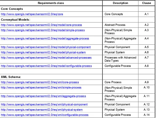
Copyright © 2014 Open Geospatial Consortium 17 Table 1 — Conformance classes related SensorML instances
Requirements class Description Clause
Core Concepts
http://www.opengis.net/spec/sensorml/2.0/req/core Core Concepts A.1
Conceptual Models:
http://www.opengis.net/spec/sensorml/2.0/req/model/core-process Abstract Process A.2 http://www.opengis.net/spec/sensorml/2.0/req/model/simple-process (Non-Physical) Simple
Process
A.3
http://www.opengis.net/spec/sensorml/2.0/req/model/aggregate-process (Non-Physical) Aggregate Process
A.4
http://www.opengis.net/spec/sensorml/2.0/req/model/physical-component Physical Component A.5 http://www.opengis.net/spec/sensorml/2.0/req/model/physical-system Physical System A.6
http://www.opengis.net/spec/sensorml/2.0/req/model/advanced-processes Processes with Advanced Data Types
A.7
http://www.opengis.net/spec/sensorml/2.0/req/model/configurable-process Configurable Process A.8
XML Schema:
http://www.opengis.net/spec/sensorml/2.0/req/xml/core-process Core Process A.9
http://www.opengis.net/spec/sensorml/2.0/req/xml/simple-process (Non-Physical) Simple Process
A.10
http://www.opengis.net/spec/sensorml/2.0/req/xml/aggregate-process (Non-Physical) Aggregate Process
A.11
http://www.opengis.net/spec/sensorml/2.0/req/xml/physical-component Physical Component A.12
Copyright © 2014 Open Geospatial Consortium
18
3 Normative References
The following normative documents contain provisions which, through reference in this text, constitute provisions of document OGC 08-094. For dated references, subsequent amendments to, or revisions of, any of these publications do not apply. However, parties to agreements based on this document are encouraged to investigate the possibility of applying the most recent editions of the normative documents indicated below. For undated references, the latest edition of the normative document referred to applies.
- OGC 08-131r3 – The Specification Model – A Standard for Modular Specification - OGC 08-094r1 – SWE Common Data Model Encoding Standard, version 2.0 - ISO/IEC 11404:2007 – General-Purpose Datatypes
- ISO 8601:2004 – Representation of Dates and Times - ISO 19103:2005 – Conceptual Schema Language - ISO 19108:2002 – Temporal Schema
- ISO 19111:2007 – Spatial Referencing by Coordinates - ISO 19115:2006 – All Metadata
- ISO 19136 - GML
- Unified Code for Units of Measure (UCUM) – Version 1.8, July 2009
- Unicode Technical Std #18 – Unicode Regular Expressions, Version 13, Aug. 2009 - The Unicode Standard, Version 5.2, October 2009
- W3C Extensible Markup Language (XML) – Version 1.0 (4th Edition), Aug. 2006 - W3C XML Schema – Version 1.0 (Second Edition), October 2004
- IEEE 754:2008 – Standard for Binary Floating-Point Arithmetic
- IETF RFC 2045 – Multipurpose Internet Mail Extensions (MIME) Part One: Format of Internet Message Bodies, November 1996
Copyright © 2014 Open Geospatial Consortium 19
4 Terms and Definitions
For the purpose of this document, the following terms and definitions apply: 4.1. Actuator
A type of transducer that converts a signal to some real-world action or phenomenon.
4.2. Aggregate Process
Composite process consisting of interconnected sub-processes, which can in turn be Simple Processes or themselves Aggregate Processes. An aggregate process can include possible data sources. A decription of an aggregate process should explicitly define connections that link input and output signals of sub-processes together. Since it is a process itself, an aggregate process also has its own inputs, outputs and parameters.
4.3. Coordinate Reference System (CRS)
A spatial or temporal framework within which a position and/or time can be defined. According to ISO 19111, a coordinate system that is related to the real world by a datum.
4.4. Coordinate System (CS)
According to ISO19111, a set of (mathematical) rules for specifying how coordinates are assigned to points. In this document, a Coordinate System is extended to be defined as a set of axes with which location and orientation can be defined.
4.5. Data Component
Element of sensor data definition corresponding to an atomic or aggregate data type
Note: A data component is a part of the overall dataset definition. The dataset structure can then be seen as a hierarchical tree of data components.
4.6. Datum
Undefined in ISO 19111. Defined here as a means of relating a coordinate system to the real world by specifying the physical location of the coordinate system and the orientation of the axes relative to the physical object. For a geodetic datum, the definition also includes a reference ellipsoid that approximates the physical or gravitational surface of the planetary body.
4.7. Detector
Atomic part of a composite MeasurementSystemdefining sampling and response characteristic of a simple detection device. A detector has only one input and one output, both being scalar quantities. More complex Sensors, such as a frame camera, which are composed of multiple detectors, can be described as a detector group or array using a System or Sensor model.
4.8. Determinand
A Parameter or a characteristic of a phenomenon subject to observation. Synonym for
observable. [O&M]
4.9. Feature
Abstraction of real-world phenomena [ISO 19101:2002, definition 4.11]
Copyright © 2014 Open Geospatial Consortium
20
4.10. Location
A point or extent in space relative to a coordinate system. For point-based systems, this is typical expressed as a set of n-dimensional coordinates within the coordinate system. For bodies, this is typically expressed by relating the translation of the origin of an object’s local coordinate system
with respect to the origin of an external reference coordinate system.
4.11. Location Model
A model that allows one to locate objects in one local reference frame relative to another
reference frame.
4.12. Measurand
Physical parameter or a characteristic of a phenomenon subject to a measurement, whose value is described using a Measure (ISO 19103). Subset of determinand or observable. [O&M]
4.13. Measure (noun)
Value described using a numeric amount with a scale or using a scalar reference system [ISO/TS 19103]
. When used as a noun, measure is a synonym for physical quantity
4.14. Measurement (noun)
An observation whose result is a measure[O&M]
4.15. Measurement (verb)
An instance of a procedure to estimate the value of a natural phenomenon, typically involving an instrument or sensor. This is implemented as a dynamic feature type, which has a property containing the result of the measurement. The measurement feature also has a location, time, and reference to the method used to determine the value. A measurement feature effectively binds a value to a location and to a method or instrument.
4.16. Muliplexed Data Stream
A data stream that consists of disparate but well defined data packets within the same stream.
4.17. Observable, Observable Property (noun)
A parameter or a characteristic of a phenomenon subject to observation. Synonym for
determinand. [O&M]
A physical property of a phenomenon that can be observed and measured (e.g. temperature, gravitational force, position, chemical concentration, orientation, number-of-individuals, physical switch status, etc.), or a characteristic of one or more feature types, the value for which will be estimated by application of some procedure in an observation. It is thus a physical stimulus that can be sensed by a detector or created by an actuator.
4.18. Observation
Act of observing a property or phenomenon [ISO/DIS 19156, definition 4.10]
Copyright © 2014 Open Geospatial Consortium 21 4.19. Observation Procedure
Method, algorithm or instrument, or system of these which may be used in making an observation [ISO/DIS 19156, definition 4.11]
Note: In the context of the sensor web, an observation procedure is often composed of one or more sensors that transform a real world phenomenon into digital information, plus additional processing steps.
4.20. Observed Value
A value describing a natural phenomenon, which may use one of a variety of scales including nominal, ordinal, ratio and interval. The term is used regardless of whether the value is due to an instrumental observation, a subjective assignment or some other method of estimation or
assignment. [O&M]
4.21. Orientation
The rotational relationship of an object relative to an external coordinate system. Typically expressed by relating the rotation of an object’s local coordinate axes relative to those axes of an external reference coordinate system.
4.22. Phenomenon
A physical state that can be observed and its properties measured.
4.23. Physical System
An aggregate model of a group or array of process components, which can include detectors, actuators, or sub-systems. A Physical System relates an Aggregate Process to the real world and therefore provides additional definitions regarding relative positions of its components and communication interfaces.
4.24. Position
The location and orientation of an object relative to an external coordinate system. For body-based systems (in lieu of point-body-based systems) is typically expressed by relating the object’s local coordinate system to an external reference coordinate system. This definition is in contrast to some definitions (e.g. ISO 19107) which equate position to location.
4.25. Process
An operation that takes one or more inputs, and based on a set of parameters, and a methodology generates one or more outputs.
4.26. Process Method
Definition of the algorithm, behaviour, and interface of a Process.
4.27. Property
Facet or attribute of an object referenced by a name [ISO/DIS 19143:2010]
Example : Abby's car has the color red, where "color" is a property of the car instance, and “red” is the value of that property.
4.28. Reference Frame
Copyright © 2014 Open Geospatial Consortium
22
4.29. Result
An estimate of the value of some property generated by a known procedure [O&M]
4.30. Sample
A representative subset of the physical entity on which an observation is made.
4.31. Sensor
An entity capable of observing a phenomenon and returning an observed value. Type of observation procedure that provides the estimated value of an observed property at its output.
Note: A sensor uses a combination of physical, chemical or biological means in order to estimate the underlying observed property. At the end of the measuring chain electronic devices often produce signals to be processed.
4.32. Sensor Model
In line with traditional definitions of the remote sensing community, a sensor model is a type of Location Model that allows one to georegister or co-register observations from a sensor
(particularly remote sensors).
4.33. Sensor Data
List of digital values produced by a sensor that represents estimated values of one or more observed properties of one or more features.
Note: Sensor data is usually available in the form of data streams or computer files. 4.34. Sensor-Related Data
List of digital values produced by a sensor that contains ancillary information that is not directly related to the value of observed properties
Example: sensor status, quality of measure, quality of service, battery life, etc. Such data can be sent in the same data stream with measured values and when measured is sometimes indistinguishable from sensor data.
4.35. (Sensor) Platform
An entity to which can be attached sensors or other platforms. A platform has an associated local coordinate reference frame that can be referenced relative to an external coordinate reference frame and to which the reference frames of attached sensors and platforms can be referenced.
4.36. Transducer
An entity that receives a signal as input and generates a modified signal as output. Includes detectors, actuators, and filters.
4.37. Value
Copyright © 2014 Open Geospatial Consortium 23
5 Conventions
5.1 Abbreviated terms
In this document the following abbreviations and acronyms are used or introduced: CRS Coordinate Reference System
DN Digital Number
ECEF Earth-Centered Earth-Fixed ECI Earth Centered Inertial GPS Global Positioning System
ISO International Organization for Standardization MISB Motion Imagery Standards Board
OGC Open Geospatial Consortium SAS Sensor Alert Service
SensorML Sensor Model Language
SI Système International (International System of Units) SOS Sensor Observation Service
SPS Sensor Planning Service SWE Sensor Web Enablement
TAI Temps Atomique International (International Atomic Time) uom Unit(s) of measure
UCUM Unified Code for Units of Measure UML Unified Modeling Language UTC Coordinated Universal Time XML eXtended Markup Language
1D One Dimensional
2D Two Dimensional
3D Three Dimensional
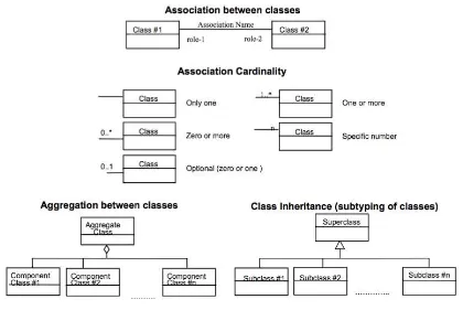
5.2 UML notation
Copyright © 2014 Open Geospatial Consortium
24
Figure 5.1 – UML Notation
5.3 Table notation used to express requirements
For clarity, each normative statement in this standard is in one and only one place and is set in a bold font within the tabular format shown below. If the statement of the requirement is repeated for clarification, the “bold font” home of the statement is considered the official statement of the normative requirement. Individual requirements are clearly highlighted and identified throughout the document by using tables and URL identifiers of the following format:
In this standard, all requirements are associated to tests in the abstract test suite in Annex A. The reference to the requirement in the test case is done by its URL.
Requirements classes are separated into their own clauses and named, and specified according to inheritance (direct dependencies). The Conformance test classes in the test suite are similarly named to establish an explicit and mnemonic link between requirements classes and conformance test classes. There are formally identified by URL and described within a tabular format as shown below:
Requirement
http://www.opengis.net/spec/sensorml/2.0/req/{req-class-name}/{req-name}
Copyright © 2014 Open Geospatial Consortium 25
Examples will be indicated using a grey text box and are considered to be informative rather than normative:
Requirements Class
http://www.opengis.net/spec/sensorml/2.0/req/{req-class-name}
Target Type Description of standardization target type
Dependency http://www.opengis.net/spec/sensorml/2.0/req/{req-class-name}
Example
Copyright © 2014 Open Geospatial Consortium
26
6 Requirements Class: Core Concepts (normative core)
Requirements Class
http://www.opengis.net/spec/sensorml/2.0/req/core
Target Type Derived Model, Encoding, and Software Implementation
6.1 Introduction
In SensorML, all components are modeled as processes. This includes components normally viewed as hardware, such as detectors, actuators, and physical processors (which are viewed as physical components) and sensors and platforms (which are viewed as physical systems). All components are modeled as processes that receive input and through the application of an algorithm defined by a method and set parameter values, generate output. All such components can therefore participate in process networks (or aggregate processes). Aggregate processes are themselves processes with their own inputs, outputs, and parameters.
Hence, SensorML can be viewed as a specialized process description language with an emphasis on application to sensor data. Process descriptions in SensorML are agnostic of the environment in which they might be executed, or the protocol by which data is exchanged between process execution modules.
In order to support the use of SensorML within specialized applications (e.g. processing centers or image processing software), the SensorML models and encodings have been divided into several conformance classes. Thus if one wishes to use SensorML for computation processes only, the software only needs to conform to the requirements for non-physical processes. Similarly, by only adhering to the Simple Process conformance class, a piece of software can describe internal processes using SensorML while supporting chaining of these processes in a proprietary way.
However, all derived model and encodings based on SensorML shall implement the core concepts of SensorML, regardless of whether they deal strictly with non-physical computational processes or sensor systems.
Requirement
http://www.opengis.net/spec/sensorml/2.0/req/core/core-concepts-used
Copyright © 2014 Open Geospatial Consortium 27 6.2 Process Definitions
In SensorML, all relevant components are modeled as processes, including both computation and physical processes (e.g. detectors, actuators, and sensor systems). Processes in SensorML are conceptually divided into two types: (1) those that are physical processes, such as detectors, actuators, and sensor systems, where information regarding their positions may be relevant, and (2) non-physical or “pure” processes which can be treated as merely mathematical operations or functions.
Fundamentally, a process is a physical or computational operation that may receive input and based on configurable parameters and a methodology, generate output.
Inputs and outputs may be digital numbers or physical stimuli (i.e. observable properties of the environment). Parameters can be variable or constant, but they don’t typically vary at the same frequency as the input values. In essence, however, parameters can be viewed as just another input into the process that is either fixed or changes less frequently than inputs
A process can consist of a single atomic operation, or an explicitly defined network of operations (e.g. an aggregate process or system).
Any process shall have a definable method of operation. In the case of an aggregate process or physical system, the explicit description of the process components and the flow of data between them will itself serve as the process methodology.
Requirement
http://www.opengis.net/spec/sensorml/2.0/req/core/processes
Req 2. The core model for a process shall define inputs, outputs, parameters, and methodology of that process.
Any process description shall provide a unique ID that can be used for discovery of that process and for retrieving the definition of that process.
Requirement
http://www.opengis.net/spec/sensorml/2.0/req/core/unique-id
Req 3. The core model for a process shall include a unique ID for distinguishing that process from all others.
Example
For a process representing the standard linear equation, x would be the input, m and b the parameters, y the output, and the equation y = mx + b would define the methodology.
Copyright © 2014 Open Geospatial Consortium
28
To be useful, the core process model shall include metadata about the process that aid in identification, discovery, and qualification of the process but do not themselves affect the execution of the process.
Requirement
http://www.opengis.net/spec/sensorml/2.0/req/core/metadata
Req 4. The core model for a process shall include metadata that support identification, discovery, and qualification of the process.
Requirement
http://www.opengis.net/spec/sensorml/2.0/req/core/execution
Req 5. The metadata descriptions for a process shall not be required for successful execution of that process. All information required for execution of a simple process shall be contained within the inputs, outputs, parameters, and methodology descriptions of the process.
Process definitions can support general representations of a process or a specific instance of a process.
Example
A general process for the linear equation would define the allowable inputs, outputs, and parameters. A specific instance of the process might define constant values for the parameters.
Copyright © 2014 Open Geospatial Consortium 29
7 UML Conceptual Models (normative)
This standard defines normative UML models with which derived encoding models as well as all future separate extensions should be compliant. The standardization target type for the UML requirements classes defined in this clause is thus a software implementation or an encoding model that directly implements the conceptual models defined in this standard.
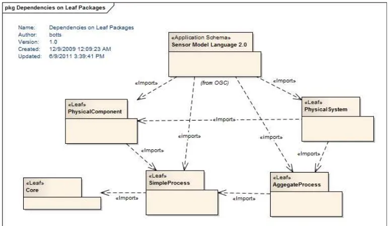
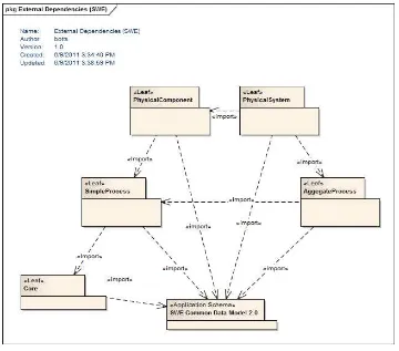
7.1 Package Dependencies
The packages defined by the SensorML Model and their dependencies are shown in figure below:
Figure 7.1 – Internal Package Dependencies
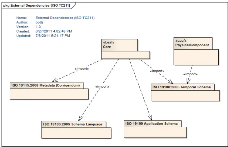
SensorML also has dependencies on several external packages defined within other standards, namely GML 3.2, ISO 19103, ISO 19108, ISO 19111, and ISO 19115, as described below.
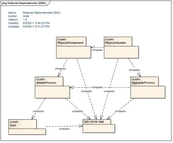
7.1.1 Dependency on GML Feature Model and ISO TC 211 Models
Copyright © 2014 Open Geospatial Consortium
30
document. This association of SensorML process with GML primarily brings recognition of SensorML processes as features and provides important identity properties.
Figure 7.2 – External Package Dependencies – GML
Copyright © 2014 Open Geospatial Consortium 31
Figure 7.3 – Models for dependent GML Feature classes
SensorML is dependent on ISO 19108:206 for Temporal Schema. In particular, the temporal elements, TM_Instant and TM_Period are used within the core SensorML model for Abstract Process. Additionally, SensorML depends on ISO 19115 for general metadata elements.
Figure 7.4 – External Package Dependencies – ISO TC 211
Copyright © 2014 Open Geospatial Consortium
32
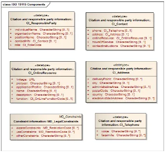
Figure 7.5 – ISO 19115 Models for dependent classes.
7.1.2 Dependency on SWE Common Data Models
Copyright © 2014 Open Geospatial Consortium 33
Figure 7.6 – External Package Dependencies – SWE Common Data
The SWE Common specification provides a flexible yet robust means of defining data types and data values, including support for simple data types such as Quantity, Boolean,
Category, Count, Text, and Time, as well as aggregate data such as DataRecord,
DataArray, Vector, and Matrix. Additionally, SWE Common supports the concept of
DataChoice, which will be utilized by SensorML for providing multiplexed messages in data streams and configurable options for processes and physical systems.
The data models in SWE Common provide additional properties than are provided by basic data types, including for example, units of measure (uom), quality indications, allowable constraints, significant digit counts, and in particular, the meaning and semantics of a data component. Both simple and aggregate data components in SWE Common allow for unambiguous definition of that data component through a resolvable link to an online dictionary or ontology. The definition of the SWE Common Data Models can be found in OGC 08-094r1.
Copyright © 2014 Open Geospatial Consortium
34
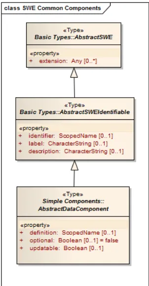
SensorML depends heavily on the AbstractDataComponent element defined in SWE Common. This element serves as the base component from which all relevant data types in SWE Common are derived, including Quantity, Count, Category, Boolean, Text,
DataRecord, DataArray, Vector, Matrix, and DataChoice. AbstractDataComponent thus serves as a substitution group that any of these data types can satisfy.
AbstractSWEIdentifiable will serve as the basis for the ObservableProperty element defined in this specification (Section 7.2.1).
The model for the SWE Common AbstractDataComponent is given in the figure below:
Figure 7.7 –Models for dependent SWE Common AbstractDataComponent class.
7.1.3 Relationship to Observations and Measurements (O&M)
Conceptual models for Observations and Measurements are provided by ISO 19156, which also provides models for sampling feature types. XML Schema encodings of these models are provided by the OGC Observations and Measurements XML Implementation Document (OGC 10-025). The model for Observation defines a procedure of type
AbstractFeature which references or describes the origin of the observation (i.e. how the observation came to be).
Copyright © 2014 Open Geospatial Consortium 35
is measuring or deriving some value of a physical property or phenomenon. Thus, the
Copyright © 2014 Open Geospatial Consortium
36
7.2 Requirements Class: Core Abstract Process
Requirements Class
http://www.opengis.net/spec/sensorml/2.0/req/model/core-process
Target Type Derived Encodings and Schema
Dependency http://www.opengis.net/spec/sensorml/2.0/req/core
Dependency OGC 08-094r1 (SWE Common Data – uml-block-components)
Dependency ISO 19115:2006 (All Metadata)
Dependency ISO 19136 (GML)
All major classes in SensorML are based on a process model, as presented in the core concepts. Processes are features as defined in ISO 19109:2006 and modeled in GML 3.2. SensorML also supports interoperable discovery, identification, and qualification of these processes through the definition of a standard collection of metadata.
Requirement
http://www.opengis.net/spec/sensorml/2.0/req/model/core-process/dependency-core
Req 6. A schema or encoding definition passing the “Core Abstract Process” model conformance class shall first pass the “Core Concepts” conformance test class.
Requirement
http://www.opengis.net/spec/sensorml/2.0/req/model/core-process/package-fully-implemented
Req 7. A schema or encoding definition shall correctly implement all UML classes defined in this section
7.2.1 ObservableProperty
Copyright © 2014 Open Geospatial Consortium 37
ObservableProperty is derived as a concrete instance of the SWE Common
AbstractSWEIdentifiable and adds the definition property to this model. It will be used as a potential input (e.g. for detectors), output (e.g. for actuators), and for parameters (e.g. for a sensor whose measurement varies with fluctuations of atmospheric pressure on a diaphragm).
In ObservableProperty the phenomenon property will be defined by reference using the
definition attribute. The definition attribute value will reference a property defined within a dictionary or ontology. An ObservableProperty may also include a name and a description. However, unlike the simple data types in SWE Common, an
ObservableProperty does NOT include the properties uom, quality, or constraints, since these are typically characteristics of the measuring procedure and not properties of the observable phenomenon itself.
7.2.2 DescribedObject
As shown in the UML model below, the DescribedObject class provides a specific set of metadata for all process classes in SensorML. Since DescribedObject is itself derived from GML AbstractFeature, all processes in SensorML are themselves features, which conforms to the conceptual models for processes as stated in Section 6.
The GML AbstractFeature inheritance provides a unique ID, and support for multiple names and a description. The unique ID in SensorML will be supported by a single
gml:identifier property inherited from GML AbstractFeature.
Requirement
http://www.opengis.net/spec/sensorml/2.0/req/model/core-process/unique-id
Req 9. A single, required gml:identifier property inherited from GML AbstractFeature shall be used to provide a unique ID for the DescribedObject.
Requirement
http://www.opengis.net/spec/sensorml/2.0/req/model/core-process/gml-dependency
Req 8. DescribedObject shall derive from the GML base class, AbstractFeature, and is thus modeled as a feature with well‐defined metadata properties. Any model or encoding derived from DescribedObject shall thus be of type featureType.
Example
Copyright © 2014 Open Geospatial Consortium
38
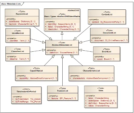
Metadata about each process is essential to supporting identification, discovery, and qualification of the process. Metadata is provided by the base class, DescribedObject, from which AbstractProcess is derived. While these metadata may provide relevant information to understand quality of output from the process, the values of properties within the DescribedObject should not be required for execution of the process. The model for the DescribedObject is shown in Figure 7.8., while the models for the individual property values are provided in either Figure 7.9 or in the ISO 19115 models in Figure 7.5.
The DescribedObject includes several descriptive properties that support rapid discovery (keywords, identification, and classification), constraints (validTime, securityConstraints,
legalConstraints), qualification (characteristics and capabilities), references (contacts
and documentation), and history. These are each grouped in lists, which provide for easy seaparation and parsing of these properties.
7.2.2.1 Extension Property
The extension property allows one to add domain or community-specific content to a
DescribedObject instance. This might include, for example, security taggings, vendor or community-specific metadata, or information encoded in other models or schema. Extension properties exist in a separate namespace and SensorML-compliant software is not required to understand or utilize the information contained within the extension property.
The constraints on the extension property include: (a) the extension model shall be defined in a separate namespace, (b) the information added by the extension model shall not be required for execution of the process, and (c) SensorML-compliant parsers may parse and utilize the information within these extensions but they are not required to do so in order to be compliant to the SensorML standard.
Requirement
http://www.opengis.net/spec/sensorml/2.0/req/model/core-process/extension-independence
Req 10. Models inside of the extension property shall exist within a namespace other than SensorML.
Requirement
http://www.opengis.net/spec/sensorml/2.0/req/model/core-process/extension-restrictions
Copyright © 2014 Open Geospatial Consortium 39
Figure 7.8 – DescribedObject with Metadata Properties
Copyright © 2014 Open Geospatial Consortium
40
7.2.2.2 Keywords
Keywords provide a simple means of discovery using short tokens that may be
recognized by the general audience or specific communities. Keywords are unqualified terms in that they are not necessarily required to be related to a specific codespace or ontology, as are classifiers and identifiers.
7.2.2.3 Identifiers
The identifier property takes a Term as its value. The Term has a definition attribute that specifies in this case the type of identifier, while the codeSpace attribute specifies that the value of the identifier is according to the rules or enumerations of a particular authority. The identification properties should be considered as information suitable for the
discovery applications.
7.2.2.4 Classifiers
The classifier property provides a list of possible classifiers that might aid in the rapid discovery or organization of processes, sensors, or sensor systems. The classifier
properties should be considered as information suitable for the discovery and categorization applications.
7.2.2.5 Security Constraints
The model for specification of security constraints will be based on external security models. The securityConstraints property takes a value of xs:Any which allows various communities and countries to utilize their standard XML encoding for security tags. This security constraint is for the overall document. As will be discussed in the XML encoding, extension points provided with SWE Common Data elements will allow security tagging for individual properties or property aggregates.
Example
An identifier with a definition of “http://sensors.ws/def/tailNumber” might take “N291PV” as its value based on the codespace of a US Air Force rules dictionary. Other possible definitions for identifiers might include, for example, shortName, longName, acronym, missionID, processorID, serialNumber, manufacturerID, or partNumber.
Example
Copyright © 2014 Open Geospatial Consortium 41
7.2.2.6 Valid Time Constraint
The validTime property indicates the time instance or time range over which this process description is valid. Time constraints are important for processes in which parameter values or operation modes may change with time, or instrument deployment times change.
7.2.2.7 Legal Constraint
The legalConstraints property is based on ISO 19115 and specifies whether such legal and ethical considerations as privacy acts, intellectual property rights, copyrights, or scientific publication ethics apply to the content of the process description and its use.
7.2.2.8 Capabilities
The capabilities property is intended for the definition of properties that further qualify the input or output of the process, component, or system for the purpose of discovery. These properties are defined using one or more SWE Common DataRecord elements. Once a user has identified candidate sensors or processes based on the classifiers described above, the capabilities parameters might prove useful for further filtering of processes or sensor system during this discovery stage. Thus, the capabilities properties should be considered as information suitable for the discovery process.
Example
Several SensorML documents can exist for the same sensor or system description but with different validity periods. This allows for capturing the configuration of a sensor at different times and, along with the history section, is the basis for maintaining history of the sensor’s description. Alternately, parameter values can be provided as a time-tagged series of values accounting for changes.
Example
One can specify the overall security classification of the entire document using the Intelligence Community Information Security Banner Marking (IC ISM) standard or using ISO 19115 MD_SecurityConstraints. For tagging individual sections in the document, the SensorML standard allows for security tagging of properties using an extension property, as describe in later sections of the standard.
Example
A particular remote sensor on a satellite might measure radiation between a certain spectral range (e.g. 700 to 900 nanometers) at a particular ground resolution (e.g. 5 meter), and with a typical spatial repeat period (e.g. 3.25 – 4.3 days). Alternatively, a particular process might have certain quality constraints. Any process may have certain limits (e.g., operational and survivable limits), based on physical or mathematical conditions.
Copyright © 2014 Open Geospatial Consortium
42
7.2.2.9 Characteristics
A physical or non-physical process may have characteristics that may not directly qualify the output. These properties are defined using one or more SWE Common DataRecord
elements.
The characteristics properties may or may not be considered as information suitable for the discovery process.
7.2.2.10 Contacts
Contact information can provide access to manufacturers, system experts, equipment owners, or any other persons responsible in some way for design, deployment, maintenance, or additional information regarding the DescribedObject. The contact
property within the ContactList takes the ISO 19115 classes CI_ResponsibleParty as its values.
7.2.2.11 Documentation
Documentation can be provided which provides further clarification about the
DescribedObject. This might include technical manuals, manufacturer brochures, journal references, or theoretical-basis documents. The DocumentList document property takes the ISO 19115 CI_OnlineResource as it value.
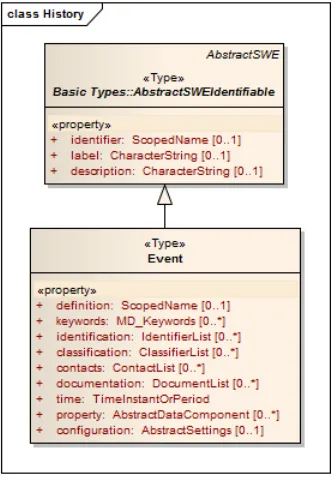
7.2.2.12 History
Within SensorML, the history of a process can be provided through a collection of Event
objects. These are provided within an EventList that serves as the value of the history
property. Events might for instance, specify calibration or maintenance history of a sensor, changes to an algorithm or parameter within a computational process, or deployment and maintenance events.
Example
Copyright © 2014 Open Geospatial Consortium 43
Figure 7.10 – Model for history events
7.2.3 AbstractProcess
As discussed in the Core Concepts, the major elements of SensorML are modeled as physical and non-physical processes. All SensorML process elements will derive from
AbstractProcess, shown in Figure 7.11. The class AbstractProcess itself derives from the
DescribedObject class and thus inherits a wide range of optional metadata supporting discovery, identification, and qualification and an option for domain and community-specific extensions. In addition to the metadata provided by DescribedObject, the
AbstractProcess includes the properties of inputs, outputs, and parameters, as required by the process model defined in the Core Concepts, as well as the properties typeOf,
Copyright © 2014 Open Geospatial Consortium
44
Figure 7.11 – UML models for DescribedObject and AbstractProcess
7.2.3.1 Inputs, Outputs, and Parameters
As discussed in the Core Concepts, any process can have inputs, outputs, and parameters. Processes typically receive input and based on the parameter settings and methodology, generate output. Some processes, such as detectors, receive physical stimulus as input and generate digital numbers as output. In such cases, the input would be represented as an ObservableProperty, and the output as a DataComponent (e.g. a Quantity). If this output is encoded and accessible directly, then the output can be represented as a
Copyright © 2014 Open Geospatial Consortium 45
Thus, an AbstractProcess model supports the inputs, outputs, and parameters properties in conformance with the Core Concepts. These properties can accept ObservableProperty
or SWE Common elements AbstractDataComponent or DataStream as their values. Classes derived from AbstractDataComponent include Quantity, Count, Category,
Boolean, Text, and Time, as well as ranges and aggregates of these simple data types.
Figure 7.12 – UML models for process inputs, outputs, and parameters.
The core process model will utilize the SWE Common Data Models for defining inputs, outputs, and parameters, as well as for other metadata properties. SensorML models are required to support the SWE Common Data Model up to the Block Components Requirements Class, but many instances of SensorML will find ALL conformance levels of SWE Common Data to be useful, including binary encodings.
Requirement
http://www.opengis.net/spec/sensorml/2.0/req/model/core-process/swe-common-dependency