Open Geospatial Consortium
Submission Date: 2016-05-30
Approval Date: 2016-11-02 Publication Date: 2017-04-06 External identifier of this OGC® document: <http://www.opengis.net/doc/IS/ows-context-geojson/1.0>
Internal reference number of this OGC® document: 14-055r2 Version: 1.0 Category: OGC®Implementation Standard Editors: Pedro Gonçalves, Roger Brackin
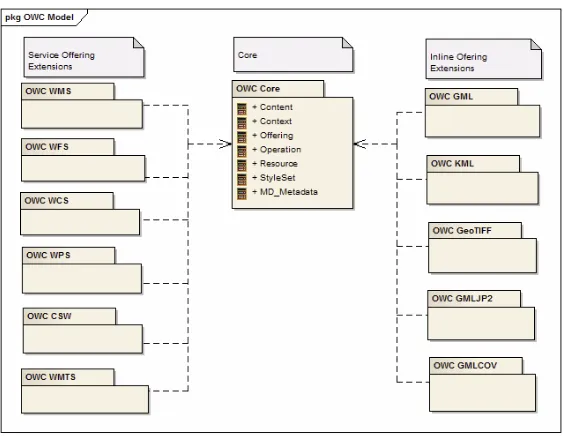
OGC OWS Context GeoJSON Encoding Standard
Copyright notice
Copyright © 2017 Open Geospatial Consortium
To obtain additional rights of use, visit http://www.opengeospatial.org/legal/.
Warning
This document is an OGC Member approved international standard. This document is available on a royalty free, non-discriminatory basis. Recipients of this document are invited to submit, with their comments, notification of any relevant patent rights of which they are aware and to provide supporting documentation.
License Agreement
Permission is hereby granted by the Open Geospatial Consortium, ("Licensor"), free of charge and subject to the terms set forth below, to any person obtaining a copy of this Intellectual Property and any associated documentation, to deal in the Intellectual Property without restriction (except as set forth below), including without limitation the rights to implement, use, copy, modify, merge, publish, distribute, and/or sublicense copies of the Intellectual Property, and to permit persons to whom the Intellectual Property is furnished to do so, provided that all copyright notices on the intellectual property are retained intact and that each person to whom the Intellectual Property is furnished agrees to the terms of this Agreement.
If you modify the Intellectual Property, all copies of the modified Intellectual Property must include, in addition to the above copyright notice, a notice that the Intellectual Property includes modifications that have not been approved or adopted by LICENSOR.
THIS LICENSE IS A COPYRIGHT LICENSE ONLY, AND DOES NOT CONVEY ANY RIGHTS UNDER ANY PATENTS THAT MAY BE IN FORCE ANYWHERE IN THE WORLD.
THE INTELLECTUAL PROPERTY IS PROVIDED "AS IS", WITHOUT WARRANTY OF ANY KIND, EXPRESS OR IMPLIED, INCLUDING BUT NOT LIMITED TO THE WARRANTIES OF MERCHANTABILITY, FITNESS FOR A PARTICULAR PURPOSE, AND NONINFRINGEMENT OF THIRD PARTY RIGHTS. THE COPYRIGHT HOLDER OR HOLDERS INCLUDED IN THIS NOTICE DO NOT WARRANT THAT THE FUNCTIONS CONTAINED IN THE INTELLECTUAL PROPERTY WILL MEET YOUR REQUIREMENTS OR THAT THE OPERATION OF THE INTELLECTUAL PROPERTY WILL BE
UNINTERRUPTED OR ERROR FREE. ANY USE OF THE INTELLECTUAL PROPERTY SHALL BE MADE ENTIRELY AT THE USER’S OWN RISK. IN NO EVENT SHALL THE COPYRIGHT HOLDER OR ANY CONTRIBUTOR OF
INTELLECTUAL PROPERTY RIGHTS TO THE INTELLECTUAL PROPERTY BE LIABLE FOR ANY CLAIM, OR ANY DIRECT, SPECIAL, INDIRECT OR CONSEQUENTIAL DAMAGES, OR ANY DAMAGES WHATSOEVER RESULTING FROM ANY ALLEGED INFRINGEMENT OR ANY LOSS OF USE, DATA OR PROFITS, WHETHER IN AN ACTION OF CONTRACT, NEGLIGENCE OR UNDER ANY OTHER LEGAL THEORY, ARISING OUT OF OR IN CONNECTION WITH THE IMPLEMENTATION, USE, COMMERCIALIZATION OR PERFORMANCE OF THIS INTELLECTUAL PROPERTY.
This license is effective until terminated. You may terminate it at any time by destroying the Intellectual Property together with all copies in any form. The license will also terminate if you fail to comply with any term or condition of this Agreement. Except as provided in the following sentence, no such termination of this license shall require the termination of any third party end-user sublicense to the Intellectual Property which is in force as of the date of notice of such termination. In addition, should the Intellectual Property, or the operation of the Intellectual Property, infringe, or in LICENSOR’s sole opinion be likely to infringe, any patent, copyright, trademark or other right of a third party, you agree that LICENSOR, in its sole discretion, may terminate this license without any compensation or liability to you, your licensees or any other party. You agree upon termination of any kind to destroy or cause to be destroyed the Intellectual Property together with all copies in any form, whether held by you or by any third party.
Contents
1. Scope ... 7
2. Conformance ... 7
3. References ... 8
4. Terms and Definitions ... 9
5. Conventions ... 9
5.1 Abbreviated Terms ... 9
5.1 Data dictionary tables ... 10
6. Overview ... 10
6.1 JavaScript Object Notation ... 11
6.2 GeoJSON Format Specification ... 11
7. GeoJSON Encoding Specification ... 12
7.1 OWS Core Context GeoJSON Encoding ... 12
7.1.1 Class OWC:Context ... 12
7.1.2 Class OWC:Resource ... 22
7.1.3 DataType OWC:Offering ... 35
7.1.4 DataType OWC:Operation ... 38
7.1.5 DataType OWC:Content ... 46
7.1.6 DataType OWC:StyleSet ... 48
7.1.7 DataType OWC:Creator ... 54
7.1.8 DataType OWC:Creator/OWC:CreatorApplication ... 54
7.1.9 DataType OWC:Creator/OWC:CreatorDisplay ... 56
7.1.10 DataType links ... 58
7.2 GeoJSON WMS Offering ... 59
7.4 GeoJSON WCS Offering ... 60
7.5 GeoJSON WPS Offering ... 60
7.6 GeoJSON CSW Offering ... 60
7.7 GeoJSON WMTS Offering ... 61
7.8 GeoJSON GML Offering ... 61
7.9 GeoJSON KML Offering ... 61
7.10 GeoJSON GeoTIFF Offering ... 62
7.11 GeoJSON GMLJP2 Offering ... 62
7.12 GeoJSON GMLCOV Offering ... 62
8. Media Types for any data encoding(s) ... 63
A.1 Conformance Test Class: core ... 64
A.2 Conformance Test Class: wms ... 65
A.3 Conformance Test Class: wfs ... 65
A.4 Conformance Test Class: wcs ... 66
A.5 Conformance Test Class: wps ... 66
A.6 Conformance Test Class: csw ... 66
A.7 Conformance Test Class: wmts ... 66
A.8 Conformance Test Class: gml ... 67
A.9 Conformance Test Class: kml ... 67
A.10 Conformance Test Class: geotiff ... 67
A.11 Conformance Test Class: gmljp2 ... 67
A.12 Conformance Test Class: gmlcov ... 68
i.
Abstract
This standard describes the GeoJSON encoding of the OGC Web Services (OWS) Context conceptual model. This standard defines how to encode an OWS context document that 1.) can be extended to allow a context referencing a fully configured service set, and 2.) can be defined and consistently interpreted by clients.
The OWS Context Document standard (OWS Context) was created to allow a set of configured information resources to be passed between applications primarily as a
collection of services (but also potentially in-line content). The objective is to support use cases such as the distribution of search results, the exchange of a set of resources in a Common Operating Picture (COP), or delivery of a set of configured processing services to allow the processing to be reproduced on different processing nodes.
The goal for OWS Context is to replace previous OGC standards and best practices that provide similar capability. Web Map Context (WMC) has been reasonably successful but is limited to working with only Web Map Service (WMS) instances. Other work on the Location Organizer Folder1 (LOF) was also taken into consideration. The concept of OWS Context and the first prototype document was produced as part of OWS Testbed 7 and documented in [OGC10-035r1], Information Sharing Engineering Report.
A principal goal of the OWS Context SWG was to develop encodings that would appeal for use in mass market applications yet also provide facilities for more advanced uses. OWS-7 originally considered the application of existing encoding standards for OWS Context. The OGC Standards Working Group (SWG) has concluded that this standard can have multiple encoding formats and that each encoding format will be described in a separate OGC Extension to the Core model.
An additional goal is that transformations of context documents between the different encodings should be lossless.
GeoJSON2 is a format for encoding collections of simple geographical features along with their non-spatial attributes using JSON. GeoJSON objects may represent a geometry, a feature, or a collection of features. GeoJSON supports the following
geometry types: Point, LineString, Polygon, MultiPoint, MultiLineString, MultiPolygon, and GeometryCollection. Features in GeoJSON contain a geometry object and additional properties, and a feature collection represents a list of features.
This document concentrates on the GeoJSON encoding of the OWS Context Model as described in abstract terms in OGC 12-080r2 OGC OWS Context Conceptual Model ( OGC 12-080r2). The goal of OWS Context is to allow many types of OGC data delivery services to be referenced and therefore exploited - not just OGC Web Map Service but
1
http://portal.opengeospatial.org/files/?artifact_id=1042 2
other OGC web services and content specifications, including but not limited to Web Feature Service, Web Coverage Service, Web Processing Service, GML, GeoTIFF and KML. This document does not explicitly define the encoding of these services and data encodings in the core, only the general approach to be used for different types of service and data interface.
ii.
Keywords
The following are keywords to be used by search engines and document catalogues.
ogcdoc, ogc documents, COP, Common Operating Picture, OWC, Context, JSON, GeoJSON
iii.
Preface
Attention is drawn to the possibility that some of the elements of this document may be the subject of patent rights. The Open Geospatial Consortium shall not be held
responsible for identifying any or all such patent rights.
Recipients of this document are requested to submit, with their comments, notification of any relevant patent claims or other intellectual property rights of which they may be aware that might be infringed by any implementation of the standard set forth in this document, and to provide supporting documentation.
iv.
Submitting organizations
The following organizations submitted this Document to the Open Geospatial Consortium (OGC):
• Envitia Ltd
• Esri Inc.
• ImageMatters LLC
• NGA
• Terradue Srl.
• Universitat Autònoma de Barcelona-CREAF
• USGS
v.
Submitters
All questions regarding this submission should be directed to the editor or the submitters:
Name Affiliation
Pedro Gonçalves Terradue Srl
Roger Brackin Envitia Ltd
Marten Hogeweg Esri Inc
Joan Maso Universitat Autònoma
de Barcelona-CREAF
David Wesloh NGA
Jeff Yutzler Image Matters LLC
1.
Scope
This document specifies how applications supporting the OWS Context GeoJSON encoding can exchange information context with other supporting applications in compliance with the OWS Context Conceptual Model.
2.
Conformance
This standard defines a standardization target for encoding an OWS Context Document. It establishes requirements classes for the ‘core’ and then for a series of offering
extensions, relating to services or content. The URIs are as follows:
• Core: http://www.opengis.net/spec/owc-geojson/1.0/req/core
• WMS: http://www.opengis.net/spec/owc-geojson/1.0/req/wms
• WFS: http://www.opengis.net/spec/owc-geojson/1.0/req/wfs
• WCS: http://www.opengis.net/spec/owc-geojson/1.0/req/wcs
• WPS: http://www.opengis.net/spec/owc-geojson/1.0/req/wps
• WMTS: http://www.opengis.net/spec/owc-geojson/1.0/req/wmts
• CSW: http://www.opengis.net/spec/owc-geojson/1.0/req/csw
• GML: http://www.opengis.net/spec/owc-geojson/1.0/req/gml
• KML: http://www.opengis.net/spec/owc-geojson/1.0/req/kml
• GeoTIFF: http://www.opengis.net/spec/owc-geojson/1.0/req/geotiff
• GMLJP2: http://www.opengis.net/spec/owc-geojson/1.0/req/gmljp2
• GMLCOV: http://www.opengis.net/spec/owc-geojson/1.0/req/gmlcov
Requirements and conformance test URIs defined in this document are relative to the base URL http://www.opengis.net/spec/owc-geojson/1.0.
Conformance with this standard shall be checked using all the relevant tests specified in Annex A (normative) of this document. The framework, concepts, and methodology for testing, and the criteria to be achieved to claim conformance are specified in the OGC Compliance Testing Policies and Procedures and the OGC Compliance Testing web site3.
Requirements for two standardization target types are considered: 1. An OWS Context Document Encoded in GeoJSON; and
2. The interpretation of an OWS Context Document by a client (Requirements and abstract tests for this are not included in this release of the document).
In order to conform to this OGC® interface standard, a software implementation shall implement:
1. Conformance to the ‘Core GeoJSON’ encoding; and
2. Conformance with zero or more of the offering-specific extensions.
All requirements-classes and conformance-classes described in this document are owned by the standard identified as OWS Context [OGC 14-055].
3.
References
The following normative documents contain provisions that, through reference in this text, constitute provisions of this document. For dated references, subsequent
amendments to, or revisions of, any of these publications do not apply. For undated references, the latest edition of the normative document referred to applies.
3.1 Normative References
1. OGC: [OGC 12-080] - OWS Context Conceptual Model, 2014
2. ECMA: [ECMA-262] - ECMA International, "ECMAScript Language
Specification, Edition 5.1", Standard ECMA-262, June 2011, http://www.ecma-international.org/publications/standards/Ecma-262.htm, 2011
3. ECMA: [ECMA-404] - The JSON Data Interchange Format http://www.ecma-international.org/publications/files/ECMA-ST/ECMA-404.pdf, 2013
4. ISO: [ISO-8601] - Data elements and interchange formats — Information interchange Representation of dates and times, Third edition, 2004
5. OGC: [OGC 05-077r4] - OGC Symbology Encoding Implementation Specification, 2006
6. OGC: [OGC 06-042] - OGC Web Map Service (WMS) Implementation Specification, 2006
7. OGC: [OGC 06-121r9] - OGC Web Service Common Implementation Specification, 2010
8. OGC: [OGC 07-036] - OGC Geography Markup Language (GML) Encoding Standard, 2007
9. IETF: [RFC-3339] - Date and Time on the Internet: Timestamps, 2002
10.IETF: [RFC-3986] - Uniform Resource Identifier (URI): Generic Syntax, 2005
11.IETF: [RFC-3987] - Internationalized Resource Identifiers (IRIs), 2005
13.W3C: [XML 1.0] - Extensible Markup Language (XML) 1.0 (Third Edition) - http://www.w3.org/TR/2004/REC-xml-20040204/, 2004
14.IETF: [RFC-7946] - The GeoJSON Format, 2016
4.
Terms and Definitions
This document uses the terms defined in Sub-clause 5.3 of [OGC 06-121r94], which is based on the ISO/IEC Directives, Part 2, Rules for the structure and drafting of
International Standards. In particular, the word “shall” (not “must”) is the verb form used to indicate a requirement to be strictly followed to conform to this standard.
For the purposes of this document, the following additional terms and definitions apply.
4.1 Area Of Interest
An Area Of Interest is a geographic area that is significant to a user.
4.2 Common Operating Picture
A single identical display of relevant information shared by more than one user group. A common operational picture facilitates collaborative planning and assists all user groups to achieve situational awareness.
4.3 Context Document
A Context Document is a document describing the set of services and their configuration, and ancillary information, such as the area of interest, which defines the information representation of a shared view or data collection.
4.4 Resource
A resource is a configured set of information that is uniquely identifiable to a user. Can be realized as in-line content or by one or more configured web services.
5.
Conventions
This section provides details and examples for any conventions used in the document. Examples of conventions are symbols, abbreviations, use of XML schema, or special notes regarding how to read the document.
5.1 Abbreviated Terms
CSW – Catalogue Services for the Web CRS – Coordinate Reference System GML – Geographical Markup Language GMLCOV - GML Coverage
GMLJP2 - GML in JPEG 2000 for Geographic Imagery HTML - Hypertext Markup Language
HTTP - Hypertext Transfer Protocol IETF - Internet Engineering Task Force IRI - Internationalized Resource Identifier
ISO - International Organization for Standardization JSON - JavaScript Object Notation
KML - Keyhole Markup Language
MIME - Multipurpose Internet Mail Extensions OGC - Open Geospatial Consortium
OWC - OGC Web Services Context OWS - OGC Web Services
RFC - Request for Comments UML - Unified Modeling Language URI - Uniform Resource Identifier URL - Uniform Resource Locator WCS - Web Coverage Service WFS - Web Feature Service WMS - Web Map Service WMTS - Web Map Tile Service WPS - Web Processing Service
XHTML - Extensible Hypertext Markup Language XML - Extensible Markup Language
5.1 Data dictionary tables
This document includes data dictionary tables related to the UML model specified in [OGC 12-080 OWS Context Conceptual Model]. The contents of the columns in these tables are described in sub-clause 5.5 of [OGC 06-121r9]. The contents of these data dictionary tables are normative, including any table footnotes.
6.
Overview
This clause specifies the links from the encoding to the underlying OWS Context data model. This clause defines a mapping for all classes and attributes of the OWS
Figure 1 - OWS Context Standard Packages
6.1 JavaScript Object Notation
JavaScript Object Notation (JSON) is a lightweight, text-based, language-independent data interchange format that defines a small set of formatting rules for the portable representation of structured data. JSON is derived from the object literals of JavaScript, as defined in the ECMAScript Programming Language Standard [ECMA-262] and can represent four primitive types (strings, numbers, boolean values, and null) and two structured types (objects and arrays). Even though JSON is based on a subset of the JavaScript Programming Language it is currently well supported by nearly all programming languages, including Java, Python, and C#.
The JSON format is currently described by two competing standards, [RFC7159] and [ECMA-404]. Both standards documents are consistent, but the latter defines mainly the grammatical syntax where the former provides some additional semantic and security points.
6.2 GeoJSON Format Specification
GeoJSONis a format for encoding collections of simple geographical features along with their non-spatial attributes using JSON. GeoJSON consists of a single object representing a geometry, feature, or collection of features. The geometries supported include Point, MultiPoint, LineString, MultiLineString, Polygon, MultiPolygon and Geometry Collections.
7.
GeoJSON Encoding Specification
This clause specifies the links from the encoding to the underlying OWS Context data model. This clause defines a mapping for all classes and attributes of the OWS
Conceptual model. This includes mandatory requirements for the encoding of a context document and the necessary semantics of how that encoding should be interpreted. The conceptual model on which this encoding is based is divided into various packages. Note that these packages map directly to requirement classes.
7.1 OWS Core Context GeoJSON Encoding
The GeoJSON object is used in the OWS Context to describe the context document.
Requirements Class
http://www.opengis.net/spec/owc-geojson/1.0/req/core
Target type Token
Dependency http://www.opengis.net/spec/owc/1.0/core
Requirement http://www.opengis.net/spec/owc-geojson/1.0/req/geojsonRules
An OWS Context document encoded in GeoJSON (GeoJSON Context Document) SHALL comply with the rules specified in [IETF GeoJSON] Requirement http://www.opengis.net/spec/owc-geojson/1.0/req/mime-type
GeoJSON OWS Context documents SHALL adopt the GeoJSON MIME-type
application/vnd.geo+json
Requirement http://www.opengis.net/spec/owc-geojson/1.0/req/file-extension
GeoJSON OWS Context documents using GeoJSON SHALL use the file extension of ‘.geojson’ or ‘.json’
Requirement http://www.opengis.net/spec/owc-geojson/1.0/req/owc-encoding
GeoJSON encoded OWS Context documents SHALL comply with the encoding rules given in the section 7.1.1.
7.1.1 Class OWC:Context
The OWC:Context Class is mapped to a GeoJSON Feature Collection object. The mapping of the OWC:Context Class in the geojson object is shown in Table 1.
Table 1 — OWC:Context mapping to geojson
Names: Conceptual GeoJSON mapping
a,d
Definition Data type and value Multiplicity
and use
<xz>.type Type of geojson object String type that SHALL have the value
“FeatureCollection”
One
Names: Conceptual GeoJSON mapping
a,d
Definition Data type and value Multiplicity
and use identifying that this is an OWC Context document and its version
Array of links profiles (as defined in Table 10 where one element SHALL have the href value
“http://www.opengis.n
et/spec/owc-geojson/1.0/req/core” in this version
One
(mandatory)
Language
<xz>.properties. lang
Language of Context document content
String type, not empty with an RFC-3066 code to the identification of the Context document (IRI)
String type that SHALL contain a URI value
One b (mandatory)
Title
<xz>.properties. title
Title for the Context document
String type, not empty One
(mandatory)
Abstract
<xz>.properties. subtitle
Description of the Context document purpose or content
String type, not empty Zero or one
(optional)
updateDate
<xz>.properties. updated
Date of a creation or update of the Context document
responsible for making the Context document
String type, not empty Zero or more
(optional) c
Publisher
<xz>.properties. publisher
Identifier for the publisher of the Context document
String type, not empty Zero or one
(optional)
Tool/application used to create the Context document and its properties
OWC:Creator (as defined in Table 7)
Zero or one (optional)
rights
<xz>.properties. rights
Information about rights held in and over the Context document
String type, not empty Zero or one
(optional)
areaOfInterest
<xz>.bbox
Names: Conceptual GeoJSON mapping
a,d
Definition Data type and value Multiplicity
and use
timeIntervalOfInterest
<xz>.date
Date or range of dates relevant to the resource
String representing a date according to the ISO-8601f format
Category related to this context document. It MAY have a related code-list that is identified by the scheme attribute
String type, not empty Zero or more
(optional)
resource
<xz>.features
Resources available on the Context document
Features array element as defined in Section 7.1.2
Reference to a resource from which the present resource is derived (e.g. source of the information)
Array of links via (as defined in Table 10)
Zero or more (optional)
Extension
<xz>.*
Any other element Any (outside of the
scope of OWS Context)
Zero or more (optional)
a This specification assigns no significance to the order of appearance of the child elements of geojson object with the exception of member of the features array (the actual Resources). The order of the member of the features MAY be used to identify the drawing order of the resources. In that case, the first item of the array represents the top most layer (see section 7.1.1.13 for further details).
b URIs used as identifiers should be in canonical form, as described by section 6 of RFC-3986. Avoid the use of URI like http://server.com/path that should be written as http://server.com/path/
c geojson objects MUST contain one or more elements on the properties.author array, unless all of the entries of the features array contain one or more elements on the properties.authors array.
d
<xz> is the name of the geojson object that depends on the implementation
e RFC 3339 defines a profile of ISO 8601 for use in Internet protocols and standards. It explicitly excludes durations and dates before the common era. The more complex formats such as week numbers and ordinal days are not permitted. https://www.ietf.org/rfc/rfc3339.txt
f See http://www.iso.org/iso/home/standards/iso8601.htm
7.1.1.1 specReference
Path: <xz>.properties.links.profiles[]
The value of this element is the OGC standard reference (requirements class) identifying that this is an OWC Context document and its version.
{
"type": "FeatureCollection",
"properties" : { "links" : { "profiles" : [
"http://www.opengis.net/spec/owc-geojson/1.0/req/core" ],
... },
"features": [{ ...
}] }
7.1.1.2 language
Path: <xz>.properties.lang
A GeoJSON Context object SHALL have a lang element. The format and interpretation of this value must follow the same rules as specified in [XML 1.0 W3C.REC], Section 2.12.
{
"type": "FeatureCollection",
"id": "http://www.opengis.net/owc/1.0/examples/geojson/1/", "properties" : {
"lang" : "en", ....
},
"features": [{ ...
}] }
7.1.1.3 id Path: <xz>.id
The id element defines a mandatory reference to the identification of the Context document. The content for the id element SHALL be an IRI, as defined by IETF [RFC-3987]. By defining the id element as an "IRI" the use of relative references is excluded and thus the id element SHALL NOT be assumed to convey dereferenceable information. The content of this element SHALL be created in a way that assures uniqueness and follows the recommendations of IETF [RFC-4287] section 4.2.6. The id should be in canonical form, i.e. including the trailing ‘/’ (so avoiding the use of URI like
http://server.com/path and using http://server.com/path
/
instead)."type": "FeatureCollection",
"id": "http://www.opengis.net/owc/1.0/examples/geojson/1/", ....
"features": [{ ...
}] }
7.1.1.4 title
Path: <xz>.properties.title
This element contains the title of the Context document. This element is mandatory and SHOULD convey a human-readable title.
{
"type": "FeatureCollection",
"id": "http://www.opengis.net/owc/1.0/examples/geojson/1/", "properties" : {
"title" : "OWS Context GeoJSON Example", ....
},
"features": [{ ...
}] }
7.1.1.5 abstract
Path: <xz>.properties.subtitle
This element is optional and contains the description of the Context Document’s purpose or content.
{
"type": "FeatureCollection",
"id": "http://www.opengis.net/owc/1.0/examples/geojson/1/", "properties" : {
"title" : "OWS Context GeoJSON Example",
"subtitle" : "This Context document uses WMS and GML", ....
},
"features": [{ ...
7.1.1.6 updateDate
Path: <xz>.properties.updated
This element is mandatory and indicates the most recent instant in time when the feed was modified in a way the publisher considers significant and does not necessarily account for minor modifications. The content of this element SHALL conform to the "date-time" production in IETF [RFC-3339]. In addition, an uppercase "T" character SHALL be used to separate date and time, and an uppercase "Z" character SHALL be present in the absence of a numeric time zone offset.
{
"type": "FeatureCollection",
"id": "http://www.opengis.net/owc/1.0/examples/geojson/1/", "properties" : {
"title" : "OWS Context GeoJSON Example", "updated" : "2012-11-04T17:26:23Z", ....
},
"features": [{ ...
}] }
7.1.1.7 author
Path: <xz>.properties.authors
This element is optional and indicates the authors array of the Context document. This element MAY contain name (conveys a human-readable name for the person), email (email address for the person) and uri (home page for the person) elements.
{
"type": "FeatureCollection",
"id": "http://www.opengis.net/owc/1.0/examples/geojson/1/", "properties" : {
"title" : "OWS Context GeoJSON Example", "authors" : [{
"name" : "Joe Doe”,
"email" : "jdoe@some.com", "uri" : "http://some.com/jdoe" }]
.... },
"features": [{ ...
7.1.1.8 publisher
Path: <xz>.properties.publisher
This element is optional and describes the entity responsible for making the Context document available. Examples of a Publisher include a person, an organization, or a service.
{
"type": "FeatureCollection",
"id": "http://www.opengis.net/owc/1.0/examples/geojson/1/", "properties" : {
"title" : "OWS Context GeoJSON Example", "publisher" : "ACME Inc.”,
.... },
"features": [{ ...
}] }
7.1.1.9 creator
Path: <xz>.properties.creator
The element is optional and expresses the entity or agent (e.g. software) responsible for making the Context document.
Example:
{
"type": "FeatureCollection",
"id": "http://www.opengis.net/owc/1.0/examples/geojson/1/", "properties" : {
"title" : "OWS Context GeoJSON Example", "creator" : "ACME CSW Server”,
.... },
"features": [{ ...
7.1.1.10 rights
Path: <xz>properties.rights
This element is optional and contains information about rights held in and over the Context document. Please note that this element SHALL NOT be used to convey machine-readable licensing information.
{
"type": "FeatureCollection",
"id": "http://www.opengis.net/owc/1.0/examples/geojson/1/", "properties" : {
"rights" : "ACME Srl, licensed under a Creative Commons Attribution 3.0 License",
.... },
"features": [{ ...
}] }
7.1.1.11 areaOfInterest Path: <xz>.bbox
This element is optional and expresses the geographic area of interest Context document using the GeoJSON “bbox” object. The value of the bbox member SHALL be a 2*n array where n is the number of dimensions represented in the contained geometries, with the lowest values for all axes followed by the highest values. The axes order of a bbox follows the axes order of geometries. In addition, the coordinate reference system for the bbox is assumed to match the coordinate reference system of the GeoJSON object of which it is a member [IETF GeoJSON].
{
"type": "FeatureCollection",
"id": "http://www.opengis.net/owc/1.0/examples/geojson/1/", "properties" : {
.... },
"bbox": [100.0, 0.0, 105.0, 1.0], "features": [{
... }] }
This element is optional and expressed a date or range of dates relevant to the Context document. It can contain the element start, stop and instant. The values of these elements SHALL conform to the "date-time" production of ISO-86015. An uppercase "T" character SHALL be used to separate date and time, and an uppercase "Z" character SHALL be present in the absence of a numeric time zone offset. To specify a range of dates the "/" character SHALL be used.
{
"type": "FeatureCollection",
"id": "http://www.opengis.net/owc/1.0/examples/geojson/1/", "properties" : {
"date": "2012-11-04T00:01:23Z/2012-12-05T17:28:56Z" ....
},
"features": [{ ...
}] }
7.1.1.13 resource Path: <xz>.features
The resources of a Context document are mapped by the array elements described below in section 7.1.2.
{
"type": "FeatureCollection",
"id": "http://www.opengis.net/owc/1.0/examples/geojson/1/", "properties" : {
.... },
"features": [{ ...
}] }
Note: This standard identifies the order of the features array element in relation to interpretation of the context document contents. Elements are ordered from highest importance to lowest in the file. In particular in relation to visualization geographically, the first entry in the GeoJSON document is the topmost layer in the display.
5
7.1.1.14 contextMetadata Path: <xz>.properties.links.via
This element is optional and references an external resource from which the Context document is derived (e.g. metadata document from which the metadata of the resource is derived). The via element is an array of link objects that contains four elements named type, href, title and lang.
{
"type": "FeatureCollection",
"id": "http://www.opengis.net/owc/1.0/examples/geojson/1/", "properties" : {
...,
"links" : { "via" : [{
"href" : "http://www.acme.com/collections/algal.xml", "type" : "application/xml ",
"title" : "Algal XML metadata", "lang" : "en"
}] .... },
"features": [{ ...
}] }
7.1.1.15 keyword
Path: <xz>.properties.categories
This array is an optional and expresses categories related to this Context document. Keyword MAY have a related code-list that is identified by the scheme attribute. Each item of the category array has one required element, term (identifies the category), and two optional elements, scheme (identifies the categorization scheme via a URI) and label (provides a human-readable label for display). This standard assigns no significance to the order of items in the array.
{
"type": "FeatureCollection",
"id": "http://www.opengis.net/owc/1.0/examples/geojson/1/", "properties" : {
...
"categories" : [{
"scheme" : "http://www.acme.com/category", "term" : "oceansec",
}]
7.1.1.16 extension
Any other element can be added to the JSON object as long as they do not clash with the elements names defined within table 1.
7.1.2 Class OWC:Resource
The list of OWC: Resource Class is mapped to an array of GeoJSON Feature objects. The mapping of the OWC:Resource Class in shown in the table below.
Table 2 - OWC:Resource mapping to feature element entry
Names: Conceptual GeoJSON mappinga,e
Definition Data type and
values
Multiplicity and use
<xz>.features[i].
type Type of geojson object String type that SHALL have the
value “Feature”
Unambiguous reference to the identification of the Context resource (IRI)
String type that SHALL contain a URI value
Title given to the Context resource
String type, not empty
Account of the content of the Context resource.
The purpose is to provide a generic description of the content in a format understandable by generic readers
String type, not empty
Date of the last update of the Context resource
String type
representing a date according to the RFC-3339 date
Entity primarily responsible for making the content of the Context resource
String type, not empty
Entity responsible for making the Context resource available
String type, not empty
Names: Conceptual GeoJSON mappinga,e
Definition Data type and
values
Information about rights held in and over the Context resource
String type, not empty
Spatial extent or scope of the content of the Context resource
GeoJSON geometry
object
Date or range of dates relevant to the Context resource
String representing a date or an interval according to the ISO-8601 format
Reference to a description of the Context resource in alternative format
Array of link objects (as defined in Table 10)
Reference to a quick-look or browse image representing the Context resource
Array of link objects (as defined in Table 10). The elements
Reference to the location of the data resource described in the Context resource
Array of link objects (as defined in Table 10)d
Service or inline content offering for the resource targeted at OGC compliant clients
Flag value indicating to the client if the Context resource should be displayed by default
Boolean
Possible values are 'true' or 'false'. Default value is ‘true’
Reference to a resource from which the Context resource is derived (e.g. source of the information)
Link object (as defined in Table 10)
Category related to this resource. It MAY have a related code-list that is identified by the scheme attribute
String type, not empty
Minimum scale for the display of the Context resource
Double Zero or one
Names: Conceptual GeoJSON mappinga,e
Definition Data type and
values
Maximum scale for the display of the Context resource
Definition of the folder in which the resource is placed
String type, not empty
Any other element Any (outside of the
scope of OWS Context)
Zero or more (optional)
a This specification assigns no significance to the order of appearance object elements.
b The features array entries MUST contain one or more elements on the authors array, unless the parent GeoJSON object contains at least one element on its authors array.
c A features array entry MUST NOT contain more than alternate element with the same combination of
type and lang element values
d Because it describes a resource potentially large in size and might require special handling the length
and type attribute SHOULD be provided.
e <xz> is the name of the geojson object that depends on the implementation
7.1.2.1 id
Path: <xz>.features[i].id
This element defines a mandatory reference to the identification of the Context resource. Its content SHALL be an IRI, as defined by RFC-3987. By defining it as an "IRI" the use of relative references is excluded and it SHALL NOT be assumed to convey
dereferencable information. The content of this element SHALL be created in a way that assures uniqueness and follow the recommendations of RFC-4287 section 4.2.6. The id should be in canonical form and avoiding the use of URI like http://server.com/path and using http://server.com/path/ instead.
{
"type": "FeatureCollection",
"id": "http://www.opengis.net/owc/1.0/examples/geojson/1/", "properties" : {
... },
"features": [{
"id": "http://www.acme.eu/geoserver/wms/#world_countries”, ...
7.1.2.2 title
Path: <xz>.features[i].properties.title
This element is mandatory and SHALL convey a human-readable title of the Context resource.
{
"type": "FeatureCollection",
"id": "http://www.opengis.net/owc/1.0/examples/geojson/1/", "properties" : {
... },
"features": [{
"id": "http://www.acme.eu/geoserver/wms/#world_countries”, "properties" : {
"title": " Base World Map”, ...
}, ... }] }
7.1.2.3 abstract
Path: <xz>.features[i].properties.abstract
This element is optional and contains the description of the Context resource purpose or content.
{
"type": "FeatureCollection",
"id": "http://www.opengis.net/owc/1.0/examples/geojson/1/", "properties" : {
... },
"features": [{
"id": "http://www.acme.eu/geoserver/wms/#MERIS”, "properties" : {
"abstract": "ENVISAT MERIS Level 1 Reduced Resolution”, ...
7.1.2.4 updateDate
Path: <xz>.features[i].properties.updated
This element is optional and contains the date of a creation or update of the Context resource (ISO-8601 date). This value indicates the most recent instant in time when the Context resource was modified in a way the publisher considers significant and not necessarily covering all any minor modifications. The content of this element SHALL conform to the "date-time" production in RFC-3339. In addition, an uppercase "T" character SHALL be used to separate date and time, and an uppercase "Z" character SHALL be present in the absence of a numeric time zone offset.
{
"type": "FeatureCollection",
"id": "http://www.opengis.net/owc/1.0/examples/geojson/1/", "properties" : {
... },
"features": [{
"id": "http://www.acme.eu/geoserver/wms/#world_countries”, "properties" : {
"updated": "2012-05-10T14:35:00.400Z”, ...
}, ... }] }
7.1.2.5 author
Path: <xz>.features[i].properties.authors[j].name
This element is optional and indicates the authors array of the Context resource. It MAY contain name (conveys a human-readable name for the person), email (email address for the person) and uri (home page for the person) elements.
{
"type": "FeatureCollection",
"id": "http://www.opengis.net/owc/1.0/examples/geojson/1/", "properties" : {
... },
"features": [{
"id": "http://www.acme.eu/geoserver/wms/#world_countries”, "title": " Base World Map”,
"name" : "Joe Doe”,
"email" : "jdoe@some.com", "uri" : "http://some.com/jdoe" }]
... }, ... }] }
7.1.2.6 publisher
Path: <xz>.features[i].properties.publisher
This element is optional and defines an entity responsible for making the Context resource available. Examples of a Publisher include a person, an organization, or a service.
{
"type": "FeatureCollection",
"id": "http://www.opengis.net/owc/1.0/examples/geojson/1/", "properties" : {
... },
"features": [{
"id": "http://www.acme.eu/geoserver/wms/#world_countries”, "properties" : {
"publisher": "ACME Project”, ...
}, ... }] }
7.1.2.7 rights
Path: <xz>.features[i].properties.rights
This element is optional and contains information about rights held in and over the Context resource. Please note that this element SHALL NOT be used to convey machine-readable licensing information
{
"type": "FeatureCollection",
... },
"features": [{
"id": "http://www.acme.eu/geoserver/wms/#world_countries”, "properties" : {
"rights": "ACME Srl, licensed under a Creative Commons Attribution 3.0 License",
... }, ... }] }
7.1.2.8 geospatialExtent
Path: <xz>.features[i].geometry
This element is optional and expresses the geographic area of interest of the Context resource according to the GeoJSON geometry object.
{
"type": "FeatureCollection",
"id": "http://www.opengis.net/owc/1.0/examples/geojson/1/", "properties" : {
... },
"features": [{
"id": "http://www.acme.eu/geoserver/wms/#world_countries”, "geometry": {
"type" : "Polygon",
"coordinates" : [[[-2,45],[8,45],[8,55],[-2,55],[-2,45]]] },
"properties" : { ...
}, ... }] }
7.1.2.9 temporalExtent
Path: <xz>.features[i].properties.date
SHALL be used to separate date and time, and an uppercase "Z" character SHALL be present in the absence of a numeric time zone offset. To specify a range of dates the "/" character SHALL be used.
{
"type": "FeatureCollection",
"id": "http://www.opengis.net/owc/1.0/examples/geojson/1/", "properties" : {
... },
"features": [{
"id": "http://www.acme.eu/geoserver/wms/#world_countries”,
"properties" : {
"date": "2009-01-23T09:08:56.000Z/2009-01-23T09:14:08.000Z", ...
}, ... }] }
7.1.2.10 preview
The preview property of the Context resource is optional and can be expressed by using the following elements:
Path: <xz>.features[i].properties.links.previews[j].href
Reference to a quick-look or browse image representing the Context resource. The attributes length and type SHOULD be provided
{
"type": "FeatureCollection",
"id": "http://www.opengis.net/owc/1.0/examples/geojson/1/", "properties" : {
... },
"features": [{
"id": "http://www.acme.eu/geoserver/wmts/#algal20090123090856”, "properties" : {
"links": {
"previews" : [{
"href" : "http://www.acme.com/products/algal20090123090856.png", "type" : "image/png",
"length" : "12321",
} ... }, ... }] }
7.1.2.11 contentDescription
Path: <xz>.features[i].properties.links.alternates[j].href
This element is optional and contains a reference to a description of the Context resource in alternative format.
{
"type": "FeatureCollection",
"id": "http://www.opengis.net/owc/1.0/examples/geojson/1/", "properties" : {
... },
"features": [{
"id": "http://www.acme.eu/geoserver/wms/#algal20090123090856”, "properties" : {
"links": {
"alternates" : [{
"href" : "http://www.acme.com/products/algal20090123090856.html", "type" : "text/html",
"title" : "Information for the entry 2009-01-23 09:08:56" }]
} ... }, ... }] }
7.1.2.12 contentByRef
Path: xz.features[i]. properties.links.data[j].href
This element is optional and contains a reference to the location of the data resource described in the Context resource. Because it describes a resource potentially large in size and might require special handling the length and type attributes SHOULD be provided.
{
"id": "http://www.opengis.net/owc/1.0/examples/geojson/1/", "properties" : {
... },
"features": [{
"id": "http://www.acme.eu/geoserver/wms/#algal20090123090856”, "properties" : {
"links": { "data" : [{
"href" : "http://www.acme.com/products/algal20090123090856.hdf", "type" : "application/x-hdf5",
"length" : "453123432",
"title" : "HDF file for the entry 2009-01-23 09:08:56" }]
} ... }, ... }] }
7.1.2.13 offering
Path: xz.features[i].properties.offerings[i]
This element is optional and can contain a number of offerings defined by the class OWC:Offering (defined in section 7.1.3 below). This standard assigns no significance to the order of appearance on the offerings array.
{
"type": "FeatureCollection",
"id": "http://www.opengis.net/owc/1.0/examples/geojson/1/", "properties" : {
... },
"features": [{
"id": "http://www.acme.eu/geoserver/wms/#algal20090123090856”, ...
"properties" : { "offerings" : [{
"code" : "http://www.opengis.net/spec/owc-geojson/1.0/req/wms", ...
},{
"code" : "http://www.opengis.net/spec/owc-geojson/1.0/req/gml", ...
}] }
7.1.2.14 active
Path: <xz>.features[i].properties.active
This element optional and is a Boolean value indicating to the client if the Context resource should be displayed by default.
Example:
{
"type": "FeatureCollection",
"id": "http://www.opengis.net/owc/1.0/examples/geojson/1/", "properties" : {
... },
"features": [{
"id": "http://www.acme.eu/geoserver/wms/#algal20090123090856”, "properties" : {
"active": true, ...
}, ... }] }
7.1.2.15 resourceMetadata
Path: xz.features[i]. properties.links.via.href
This element is optional and contains a reference to a resource from which the present resource is derived. Any alternative representation of the resource should use the alternative representation shown in 7.1.2.10.
{
"type": "FeatureCollection",
"id": "http://www.opengis.net/owc/1.0/examples/geojson/1/", "properties" : {
... },
"features": [{
"properties" : { "links": { "via" : {
"href" : "http://www.acme.com/products/algal20090123090856.xml", "type" : "application/xml",
"length" : "435",
"title" : "XML metadata file for the entry 2009-01-23 09:08:56" }
} ... }, ... }] }
7.1.2.16 keyword
Path: <xz>.features[i].properties.categories[j].term
This array is optional and expresses a category related to the Context resource. Keyword MAY have a related code-list that is identified by the scheme attribute. Each item of the category array has one required element, term (identifies the category), and two optional elements, scheme (identifies the categorization scheme via a URI) and label (provides a human-readable label for displaying). This standard assigns no significance to the order of items in the array.
{
"type": "FeatureCollection",
"id": "http://www.opengis.net/owc/1.0/examples/geojson/1/", "properties" : {
... },
"features": [{ ...
"properties" : { "categories" : [{
"scheme" : "http://www.acme.com/category", "term" : "high_concentration",
"label" : "High Concentration was detected on this entry" },{
"scheme" : "http://www.earthobservations.org/category", "term" : "GEOSSDataCore",
"label" : "GEOSS Data Collection of Open Resources for Everyone" },{
}] }
7.1.2.17 minScaleDenominator
Path: <xz>.features[i].properties.minscaledenominator
This element is optional and defines the minimum scale denominator for the display of the resource. The scale denominator is defined with respect to a “standardized rendering pixel size” of 0.28 mm × 0.28 mm (millimeters). The definition is the same used in WMS 1.3.0 [OGC 06-042] and in the OGC Symbology Encoding Implementation Specification 1.1.0 [05-077r4]. Frequently, the true pixel size is unknown and 0.28 mm is a common actual size for current displays.
{
"type": "FeatureCollection",
"id": "http://www.opengis.net/owc/1.0/examples/geojson/1/", "properties" : {
... },
"features": [{
"id": "http://www.acme.eu/geoserver/wms/#algal20090123090856”, "properties" : {
"minscaledenonimator" : 100.0, ...
}, ... }] }
7.1.2.18 maxScaleDenominator
Path: <xz>.features[i].properties.maxscaledenominator
This element is optional and defines the maximum scale denominator for the display of the resource. The scale denominator is defined with respect to a “standardized rendering pixel size” of 0.28 mm × 0.28 mm (millimeters). The definition is the same used in WMS 1.3.0 [OGC 06-042] and in the OGC Symbology Encoding Implementation Specification 1.1.0 [05-077r4]. Frequently, the true pixel size is unknown and 0.28 mm is a common actual size for current displays.
{
"type": "FeatureCollection",
... },
"features": [{
"id": "http://www.acme.eu/geoserver/wms/#algal20090123090856”, "properties" : {
"maxscaledenominator" : 1000000.0, ...
}, ... }] }
7.1.2.19 folder
Path: <xz>.features[i].properties.folder
This element is optional and defines the folder name in a folder structure in which the resource is placed.
{
"type": "FeatureCollection",
"id": "http://www.opengis.net/owc/1.0/examples/geojson/1/", "properties" : {
... },
"features": [{
"id": "http://www.acme.eu/geoserver/wms/#algal20090123090856”, "properties" : {
"folder" : "/root/algal", ...
}, ... }] }
7.1.2.20 extension
Any other element can be added to the JSON object as long as they do not clash with the elements names defined within table 2.
7.1.3 DataType OWC:Offering
Table 3 - Definitions of owc:Offering elements
Names: Conceptual JSON mapping a
Definition Data type and
values
Multiplicity and use
code
<off>.code
Code identifying the type of offering
URI
A requirement class identifier (URI) for the extension defining the operation. See sections 7.1.9.1 to 7.12
One (mandatory)
operation
<off>.
operations[k]
Array of operations used to invoke the service
owc:OperationType,
Array of contents (inline or byRef)
Array of style sets owc:StyleSetType,
see Table 6
Zero or more (optional) extension
<off>.*
Any other element Any (outside of the
scope of OWS Context)
Zero or more (optional)
a
<off> is the name of the offering object in the offerings Array <xz>.features[i].properties. offerings[j]. <xz>.is the name of the geojson object.
7.1.3.1 code
Path: <xz>.features[i].properties.offerings[j].code
The offering code is defined as the requirement class identifier (URI) for the extension defining the operation. “code” can be an OWC extension or one defined in a profile.
{
"type": "FeatureCollection",
"id": "http://www.opengis.net/owc/1.0/examples/geojson/1/", "properties" : {
... },
"features": [{
"id": "http://www.acme.eu/geoserver/wms/#algal20090123090856”, ...
"properties" : { "offerings" : [{
"code" : "http://www.opengis.net/spec/owc-geojson/1.0/req/wms", ...
},{
"code" : "http://www.opengis.net/spec/owc-geojson/1.0/req/gml", ...
... }] }
7.1.3.2 operation
Path: <xz>.features[i].properties.offerings[j].operations[k]
Defines an operation within an offering. Valid operations for an offering are defined in the relevant offering extension (Section 8.2.4 Class OWC:Operation).
{
"type": "FeatureCollection",
"id": "http://www.opengis.net/owc/1.0/examples/geojson/1/", "properties" : {
... },
"features": [{
"id": "http://www.acme.eu/geoserver/wms/#algal20090123090856”, ...
"properties" : { "offerings" : [{
"code" : "http://www.opengis.net/spec/owc-geojson/1.0/req/wms", "operations" : [{
"code" : "GetCapabilities",
"href" : "http://www.someserver.com/wrs.cgi?REQUEST=GetCapabilities& amp;SERVICE=WMS&VERSION=1.1.1"
}] ... },{
"code" : "http://www.opengis.net/spec/owc-geojson/1.0/req/gml", ...
}] ... }] }
7.1.3.3 content
Path: <xz>.features[i].properties.offerings[j].contents[k]
7.1.3.4 styleSet
Path: <xz>.features[i].properties.offerings[j].styles[k]
Defines a style within an offering of the OWC:StyleSet (see section 7.1.6 class for further details).
7.1.3.5 extension
Any other element can be added to the JSON object as long as they do not clash with the elements names defined within table 3.
7.1.4 DataType OWC:Operation
This class defines the operation either to get the information or to get the capabilities. Note that service specific extension requirements may mandate more than one operation. As such this element is an array of operations.
Table 4 - Definitions of owc:Operation elements
Names: Conceptual JSON mapping
Definition Data type and
values
Multiplicity and use
code
<op>.code
Code identifying the type of Operation
String type, not emptya
One
(mandatory)
method
<op>.method
Code identifying the HTTP verb type of Operation.
String type, not empty. Example values are GET and POST.
One
(mandatory)
type
<op>.type
MIME type of the expected results
String type, not empty that contains a MIME media
Optional request body content
c owc:ContentType,
Optional Result Payload of the operationc
Any other element Any (outside of the
scope of OWS Context)
Names: Conceptual JSON mapping
Definition Data type and
values
Multiplicity and use
a Typically the OGC Service request type, e.g. “GetCapabilities” or “GetMap”.
b
Full request URL for an HTTP GET, and request URL for HTTP POST.
c
Not necessarily XML as the content is defined by MIME-type. If the content is text/xml or
application/*+xml it SHALL be present as a XML fragment (without the <?xml... header) and the encoding SHALL be the same as the feed.
e
<op> is the name of the operation object in the operations Array
<xz>.features[i].properties.offerings[j].operations[k]. <xz>.is the name of the geojson
object.
7.1.4.1 code
Path: <xz>.features[i].properties.offerings[j].operations[k].code
This identifies the type of operation. The valid operation types are defined within each specific extension within the OWS Context conceptual model [OGC 12-080].
{
"type": "FeatureCollection",
"id": "http://www.opengis.net/owc/1.0/examples/geojson/1/", "properties" : {
... },
"features": [{
"id": "http://www.acme.eu/geoserver/wms/#algal20090123090856”, ...
"properties" : { "offerings" : [{
"code" : "http://www.opengis.net/spec/owc-geojson/1.0/req/wms", "operations" : [{
"code" : "GetCapabilities",
"href" : "http://www.someserver.com/wrs.cgi?REQUEST=GetCapabilities& amp;SERVICE=WMS&VERSION=1.1.1"
}] ... },{
"code" : "http://www.opengis.net/spec/owc-geojson/1.0/req/gml", ...
}] ... }] }
7.1.4.2 method
This identifies the method (verb) of the operation. Default value is GET.
{
"type": "FeatureCollection",
"id": "http://www.opengis.net/owc/1.0/examples/geojson/1/", "properties" : {
... },
"features": [{
"id": "http://www.acme.eu/geoserver/wms/#algal20090123090856”, ...
"properties" : { "offerings" : [{
"code" : "http://www.opengis.net/spec/owc-geojson/1.0/req/wms", "operations" : [{
"code" : "GetCapabilities", "method" : "GET",
"href" : "http://www.someserver.com/wrs.cgi?REQUEST=GetCapabilities& amp;SERVICE=WMS&VERSION=1.1.1"
}] ... },{
"code" : "http://www.opengis.net/spec/owc-geojson/1.0/req/gml", ...
}] ... }] }
7.1.4.3 type
Path: <xz>.features[i].properties.offerings[j].operations[k].type
“type” defines the MIME-type of the content class.
{
"type": "FeatureCollection",
"id": "http://www.opengis.net/owc/1.0/examples/geojson/1/", "properties" : {
... },
"features": [{
"id": "http://www.acme.eu/geoserver/csw/oceans”, ...
"properties" : { "offerings" : [{
"operations" : [{
"code" : "GetRecords", "type" : "application/xml" "method" : "POST",
"href" : "http://www.someserver.com/wrs.cgi?service=CSW&request= GetCapabilities&VERSION=2.0.2"
}] }] ... }] }
7.1.4.4 requestURL
Path: <xz>.features[i].properties.offerings[j].operations[k].href
For HTTP GET the serviceURL item is used to capture the entire request. For POST (and SOAP) requests, the serviceURL is used to capture the address, and an additional request element (section 7.1.4.5) may be specified.
{
"type": "FeatureCollection",
"id": "http://www.opengis.net/owc/1.0/examples/geojson/1/", "properties" : {
... },
"features": [{
"id": "http://www.acme.eu/geoserver/wms/#algal20090123090856”, ...
"properties" : { "offerings" : [{
"code" : "http://www.opengis.net/spec/owc-geojson/1.0/req/wms", "operations" : [{
"code" : "GetCapabilities", "method" : "GET",
"href" : "http://www.someserver.com/wrs.cgi?REQUEST=GetCapabilities& amp;SERVICE=WMS&VERSION=1.1.1"
7.1.4.5 request
Path: <xz>.features[i].properties.offerings[j].operations[k].request.content
request is an optional element of the type OWC:Content that captures the request of an operation as it was sent to the server. This can be defined inline or as a reference. For POST and SOAP Requests, an element request with the payload contents may be required.
Note: not necessarily XML as the content is defined by MIME-type. If the content is text/xml or application/xml+* it SHALL be present as a XML fragment (without the <?xml... header) and the encoding SHALL be the same as the feed.
{
"type": "FeatureCollection",
"id": "http://www.opengis.net/owc/1.0/examples/geojson/1/", "properties" : {
... },
"features": [{
"id": "http://www.acme.eu/geoserver/csw/oceans/”, ...
"properties" : { "offerings" : [{
"code" : "http://www.opengis.net/spec/owc-geojson/1.0/req/csw", "operations" : [{
"code" : "GetCapabilities", "method" : "GET",
"href" : "http://www.someserver.com/wrs.cgi?service=CSW&request= GetCapabilities&VERSION=2.0.2"
},{
"code" : "GetRecords", "type" : "application/xml", "method" : "POST",
"href" : "http://www.someserver.com/wrs.cgi?service=CSW&request= GetCapabilities&VERSION=2.0.2",
"request":{
"type" : "application/xml",
"content" : "<csw:GetRecords maxRecords=\"10\" outputFormat=\"application/xml\"
outputSchema=\"http://www.isotc211.org/2005/gmd\" resultType=\"results\" service=\"CSW\" startPosition=\"1\" version=\"2.0.2\"
xmlns:ogc=\"http://www.opengis.net/ogc\"
xmlns:csw=\"http://www.opengis.net/cat/csw/2.0.2\"><csw:Query typeNames=\"csw:Record Service Association\"