Open Geospatial Consortium
Publication Date: 2014-02-24 Approval Date:2013-09-25 Submission Date:2013-09-22
Reference number of this document:OGC 13-046r2
Reference URL for this document:http://www.opengis.net/doc/PER/chisp1-summary-er
Category: Public Engineering Report
Editor:Lew Leinenweber
OGC
CHISP-1 Summary Engineering Report
Copyright © 2013 Open Geospatial Consortium.
To obtain additional rights of use, visit http://www.opengeospatial.org/legal/
Warning
This document is not an OGC Standard. This document is an OGC Public
Engineering Report created as a deliverable in an OGC Interoperability Initiative and is not an official position of the OGC membership. It is distributed for review and comment. The document is subject to change without notice and may not be referred to as an OGC Standard. Further, any OGC Engineering Report should not be referenced as required or mandatory technology in procurements.
Document type: OGC® Engineering Report
Document subtype: NA
Document stage: Approved for public release
OGC 13-046r2 CHISP-1 Summary Engineering Report
ii Copyright © 2013 Open Geospatial Consortium.
Preface
The CHISP-1 initiative was conducted as a Pilot initiative, which is a collaborative effort that applies technology elements from the OGC Technical Baseline and other (non-OGC) technologies to address Sponsor requirements and scenarios.
OGC Pilot initiatives are part of OGC's Interoperability Program, a global, hands-on and collaborative prototyping program designed to rapidly develop, test and deliver proven candidate standards into OGC's Standards Program, where they are formalized for public release. In OGC's Interoperability Initiatives, international teams of technology providers work together to solve specific geo-processing interoperability problems posed by the Initiative's sponsoring organizations. OGC Interoperability Initiatives include test beds, pilot projects, interoperability experiments and interoperability support services - all designed to encourage rapid development, testing, validation and adoption of OGC standards.
This report summarizes the results of OGC’s Climatology-Hydrology Information Sharing Pilot, Phase 1 (CHISP-1). The objective of this initiative was to develop an inter-disciplinary, inter-agency and international virtual observatory system for water resources information from observations in the U.S. and Canada, building on current networks and capabilities.
The CHISP-1 Initiative was designed to support these Use Case functions: Hydrologic modeling for historical and current stream flow and groundwater
conditions
Modeling and assessment of nutrient load into the Great Lakes
OGC 13-046r2
Copyright © 2013 Open Geospatial Consortium. iii
License Agreement
Permission is hereby granted by the Open Geospatial Consortium, ("Licensor"), free of charge and subject to the terms set forth below, to any person obtaining a copy of this Intellectual Property and any associated documentation, to deal in the Intellectual Property without restriction (except as set forth below), including without limitation the rights to implement, use, copy, modify, merge, publish, distribute, and/or sublicense copies of the Intellectual Property, and to permit persons to whom the Intellectual Property is furnished to do so, provided that all copyright notices on the intellectual property are retained intact and that each person to whom the Intellectual Property is furnished agrees to the terms of this Agreement.
If you modify the Intellectual Property, all copies of the modified Intellectual Property must include, in addition to the above copyright notice, a notice that the Intellectual Property includes modifications that have not been approved or adopted by LICENSOR. THIS LICENSE IS A COPYRIGHT LICENSE ONLY, AND DOES NOT CONVEY ANY RIGHTS UNDER ANY PATENTS THAT MAY BE IN FORCE ANYWHERE IN THE WORLD.
THE INTELLECTUAL PROPERTY IS PROVIDED "AS IS", WITHOUT WARRANTY OF ANY KIND, EXPRESS OR IMPLIED, INCLUDING BUT NOT LIMITED TO THE WARRANTIES OF MERCHANTABILITY, FITNESS FOR A PARTICULAR PURPOSE, AND NONINFRINGEMENT OF THIRD PARTY RIGHTS. THE COPYRIGHT HOLDER OR HOLDERS INCLUDED IN THIS NOTICE DO NOT WARRANT THAT THE FUNCTIONS CONTAINED IN THE INTELLECTUAL PROPERTY WILL MEET YOUR REQUIREMENTS OR THAT THE OPERATION OF THE INTELLECTUAL PROPERTY WILL BE
UNINTERRUPTED OR ERROR FREE. ANY USE OF THE INTELLECTUAL PROPERTY SHALL BE MADE ENTIRELY AT THE USER’S OWN RISK. IN NO EVENT SHALL THE COPYRIGHT HOLDER OR ANY CONTRIBUTOR OF
INTELLECTUAL PROPERTY RIGHTS TO THE INTELLECTUAL PROPERTY BE LIABLE FOR ANY CLAIM, OR ANY DIRECT, SPECIAL, INDIRECT OR CONSEQUENTIAL DAMAGES, OR ANY DAMAGES WHATSOEVER RESULTING FROM ANY ALLEGED INFRINGEMENT OR ANY LOSS OF USE, DATA OR PROFITS, WHETHER IN AN ACTION OF CONTRACT, NEGLIGENCE OR UNDER ANY OTHER LEGAL THEORY, ARISING OUT OF OR IN CONNECTION WITH THE IMPLEMENTATION, USE, COMMERCIALIZATION OR PERFORMANCE OF THIS INTELLECTUAL PROPERTY. This license is effective until terminated. You may terminate it at any time by destroying the Intellectual Property together with all copies in any form. The license will also terminate if you fail to comply with any term or condition of this Agreement. Except as provided in the following sentence, no such termination of this license shall require the termination of any third party end-user sublicense to the Intellectual Property which is in force as of the date of notice of such termination. In addition, should the Intellectual Property, or the operation of the Intellectual Property, infringe, or in LICENSOR’s sole opinion be likely to infringe, any patent, copyright, trademark or other right of a third party, you agree that LICENSOR, in its sole discretion, may terminate this license without any compensation or liability to you, your licensees or any other party. You agree upon termination of any kind to destroy or cause to be destroyed the Intellectual Property together with all copies in any form, whether held by you or by any third party. Except as contained in this notice, the name of LICENSOR or of any other holder of a copyright in all or part of the Intellectual Property shall not be used in advertising or otherwise to promote the sale, use or other dealings in this Intellectual Property without prior written authorization of LICENSOR or such copyright holder. LICENSOR is and shall at all times be the sole entity that may authorize you or any third party to use certification marks, trademarks or other special designations to indicate compliance with any LICENSOR standards or specifications.
This Agreement is governed by the laws of the Commonwealth of Massachusetts. The application to this Agreement of the United Nations Convention on Contracts for the International Sale of Goods is hereby expressly excluded. In the event any provision of this Agreement shall be deemed unenforceable, void or invalid, such provision shall be modified so as to make it valid and enforceable, and as so modified the entire Agreement shall remain in full force and effect. No decision, action or inaction by LICENSOR shall be construed to be a waiver of any rights or remedies available to it.
OGC 13-046r2 CHISP-1 Summary Engineering Report
iv Copyright © 2013 Open Geospatial Consortium.
Contents
Page1 Overview ... 1
2 Organizations in CHISP-1 ... 2
2.1 Sponsoring Organizations ... 2
2.2 List of Participating Organizations ... 2
2.3 CHISP-1 IP Team ... 3
3 Milestone Schedule ... 3
4 Development Objective and Results ... 4
4.1 CHISP-1 Engineering Report ... 4
4.2 CHISP-1 Scenarios Use Cases ... 4
4.2.1 Hydrologic modeling for historical and current stream flow and groundwater conditions ... 4
4.2.2 Architecture – Upstream Monitoring and Event Notification Scenario ... 6
4.2.3 Modeling and assessment of nutrient load into the Great Lakes ... 7
4.2.4 Architecture – Great Lakes Nutrient Load Calculation Scenario ... 8
4.3 CHISP-1 Client and Service Components ... 9
5 Achievements ... 10
6 Future work. ... 11
6.1 Catalogue ... 11
6.2 Big Data Handling ... 11
6.3 Semantic Mediation ... 12
6.4 Service Performance ... 12
6.5 Subscription Client Improvements ... 12
6.6 Event Notification Service (ENS) Enhancements ... 12
6.7 Nutrient Load Calculation Model ... 13
Figures
Page Figure 1, Scenario 1 – Milk River Basin ... 5Figure 2, Scenario 1 – Souris-Red River Basins ... 5
Figure 3, Scenario 1 - Upstream Monitoring and Event Notification Architecture ... 6
Figure 4, Scenario 2 – Lake Erie Basin and Lake Ontario Basin ... 7
OGC 13-046r2
Copyright © 2013 Open Geospatial Consortium. v
Tables
PageTable 1, CHISP-1 Milestone Schedule ... 3
Table 2, Pre-existing components used in CHISP-1 ... 9
CHISP-1 Summary Engineering Report OGC 13-046r2
Copyright © 2013 Open Geospatial Consortium. 1
OGC
®CHISP-1 Summary Engineering Report
Summary of OGC Climatology-Hydrology Information
Sharing Pilot, Phase 1 (CHISP-1)
1 Overview
The Climatology-Hydrology Information Sharing Pilot, Phase 1 (CHISP-1) was an initiative of OGC’s Interoperability Program. The Pilot was a collaborative effort that applied technology elements from the OGC Technical Baseline and other (non-OGC) technologies to Sponsor scenarios. The Pilot was conducted to “stress test” a set of OGC standards based on real-world application and experience. The majority of work for CHISP-1 was conducted from November 2012 through April 2013, with the following outcomes:
18 Components were developed or deployed for the Pilot to demonstrate system functions and interoperability by participants and sponsor organizations
An Engineering Report (ER) was prepared to capture the technical architecture, description of the system functions developed to address Sponsor provided Use Cases, and Lessons-learned along with recommendations for Next Steps. A live presentation and demonstration was conducted in the form of a public
webinar, hosted and broadcast by Directions Media, on 16 April 2013. Recording of the webinar is available for review by the public here:
http://www.directionsmag.com/webinars/view/ogc-update-results-of-the-climate-hydrologic-information-sharing-pilot/318678
10 organizations were involved in the CHISP-1 initiative consisting of 3 participants and 7 sponsor organizations. Additionally, a number of other organizations were observers on the project.
OGC 13-046r2 CHISP-1 Summary Engineering Report
2 Copyright © 2013 Open Geospatial Consortium.
1.1 Document contributor contact points
All questions regarding this document should be directed to the editor or the contributors:
Name Organization
Lew Leinenweber Open Geospatial Consortium Peter Vretanos CubeWerx
1.2 Revision history
Added contact points and revision history tables
Corrected OGC doc number in page headers
Editorial updates in a number of sections.
2 Organizations in CHISP-1
2.1 Sponsoring Organizations
CHISP-1 was sponsored by the following organizations: Environment Canada
Natural Resources Canada (NRCan) GeoConnections
NRCan Groundwater Science Program US Geological Service (USGS)
Environmental Protection Agency (EPA)
2.2 List of Participating Organizations
The following OGC member organizations were participants in this project.
OGC 13-046r2
Copyright © 2013 Open Geospatial Consortium. 3
RPS ASA (Applied Science Associates)
GIS Research Center, Feng Chia University (GIS.FCU)
Additionally, there were 7 other organizations that were observers for the CHISP-1 project.
2.3 CHISP-1 IP Team
The IP Team is an engineering and management team to oversee and coordinate an OGC Interoperability Initiatives. The IP Team facilitates architectural discussions, synopsizes technology threads, and supports the specification editorial process. The IP Team is comprised of OGC staff and representatives from member organizations. The CHISP-1 IP Team was as follows:
Interoperability Program Chief Engineer: George Percivall, OGC Interoperability Program Executive Director: Nadine Alameh, OGC Initiative Director: Lewis Leinenweber, OGC
Thread Architect: Panagiotis (Peter) A. Vretanos, CubeWerx
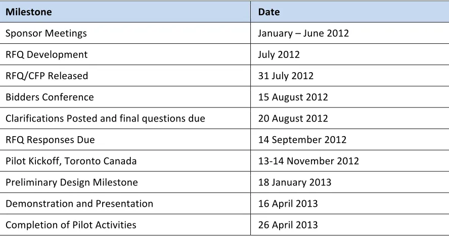
3 Milestone Schedule
The CHISP-1 Pilot project was planned and conducted as shown in the following table of milestones.
Table 1, CHISP-1 Milestone Schedule
OGC 13-046r2 CHISP-1 Summary Engineering Report
4 Copyright © 2013 Open Geospatial Consortium.
4 Development Objective and Results
The objective of this initiative was to develop an inter-disciplinary, inter-agency and international virtual observatory system for water resources information from
observations in the U.S. and Canada, building on current networks and capabilities. The CHISP-1 Initiative was designed to support these Use Case functions:
Hydrologic modeling for historical and current stream flow and groundwater
conditions. Integrate trans-boundary stream flow and groundwater well data, as well as national river networks (US NHD and Canada NHN) from multiple agencies with emphasis on time series data encoded as WaterML2 and real-time flood monitoring. Modeling and assessment of nutrient load into the Great Lakes. Access water-quality
data from multiple agencies and integrate with stream flow information for calculating nutrient loads. Emphasis was on discrete sampled water quality observations, linking those to specific NHD stream reaches and catchments, and additional metadata for sampled data.
4.1 CHISP-1 Engineering Report
The detailed technical results for the CHISP-1 initiative are documented in the following Engineering Report
OGC 13-053, CHISP-1 Engineering Report
4.2 CHISP-1 Scenarios Use Cases
The following paragraphs describe in more detail the Use Cases developed in the CHISP-1 pilot.
4.2.1 Hydrologic modeling for historical and current stream flow and groundwater conditions
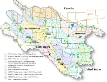
This scenario focuses on accessing river gage and groundwater well information
associated with a river network that in turn is associated with a set of basins (watersheds). Millions of stream gages and well monitors have been installed throughout the U.S. and Canada, reporting continuous values of depth, flow rate and/or other parameters, as time series. The purpose of this use case is to provide seamless access and interoperability of this data across the U.S.-Canada border.
Several water catchment basins cross this border. The Pilot region considered two basins with portions in both the U.S. and Canada. The Milk River basin includes parts of
OGC 13-046r2
Copyright © 2013 Open Geospatial Consortium. 5
Figure 1, Scenario 1 – Milk River Basin
Source: http://www.umt.edu/watershedclinic/images/clip_image002.jpg
The Souris River flows into the Assiniboine River, then into the Red River and Lake Winnipeg, which is part of the Hudson Bay. The Souris River basin shows the locations of stream gauges as green circles (source: http://nd.water.usgs.gov/floodinfo/souris.html).
Figure 2, Scenario 1 – Souris-Red River Basins
OGC 13-046r2 CHISP-1 Summary Engineering Report
6 Copyright © 2013 Open Geospatial Consortium.
The CHISP-1 Pilot initiative selected the Milk River as the area of interest to focus on services and data to support the Use Case scenario. More specifically, this Use Case focused on exchanging cross-border hydrologic data (stream flow and groundwater levels) with a unified alert service. Stream/river gauge and groundwater well locations associated with a river network and in turn associated with a set of basins (watersheds). For any well or stream gauge location, a web service was developed to provide access to the gauge and well information on all upstream stream segments or in all contributing basins. An event service was developed to provide subscribers with a notification if any upstream streamflow or well water level reaches or exceeds a user-defined threshold. The selected Milk River basin crosses the U.S./Canada border. Data providers were identified and selected from include provincial and federal agencies. Based on sensor events, a flood is determined to be imminent and alert is generated for distribution to authorities in the affected areas.
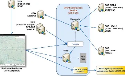
4.2.2 Architecture – Upstream Monitoring and Event Notification Scenario
The CHISP-1 system architecture for this Use Case is represented in the following diagram.
OGC 13-046r2
Copyright © 2013 Open Geospatial Consortium. 7
4.2.3 Modeling and assessment of nutrient load into the Great Lakes
This scenario focuses on calculating nutrient loads (particularly Nitrogen and Phosphorus) flowing into the Great Lakes from tributaries (e.g., via hydrologic
pathways), using web-accessible inputs of water quality observations and flow rates. The system produces web-accessible outputs of known nutrient loads that includes metadata to document the model output and processing steps. The project focused on the Lake Ontario basins as shown in the following diagram.
Figure 4, Scenario 2 – Lake Erie Basin and Lake Ontario Basin
OGC 13-046r2 CHISP-1 Summary Engineering Report
8 Copyright © 2013 Open Geospatial Consortium.
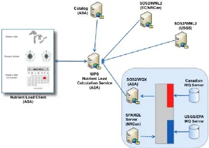
4.2.4 Architecture – Great Lakes Nutrient Load Calculation Scenario
The CHISP-1 architecture implemented for this Nutrient Load Calculation Use Case is represented in the following diagram.
OGC 13-046r2
Copyright © 2013 Open Geospatial Consortium. 9
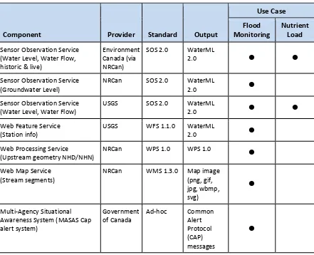
4.3 CHISP-1 Client and Service Components
Pre-existing System and Service components shown in Table 2 were deployed and used in the CHISP-1 initiative.
Table 2, Pre-existing components used in CHISP-1
Component Provider Standard Output
Use Case
(Groundwater Level) NRCan SOS 2.0 WaterML 2.0
Sensor Observation Service
(Water Level, Water Flow) USGS SOS 2.0 WaterML 2.0
Web Feature Service
(Station info) USGS WFS 1.1.0 WaterML 2.0
Web Processing Service
(Upstream geometry NHD/NHN) NRCan WPS 1.0 WPS 1.0
Web Map Service
OGC 13-046r2 CHISP-1 Summary Engineering Report
10 Copyright © 2013 Open Geospatial Consortium.
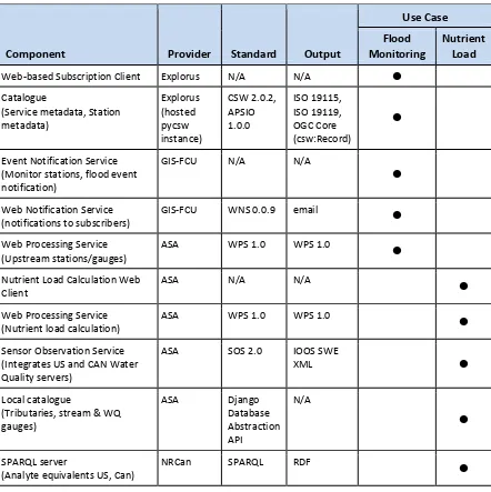
Components shown in Table 3 were developed and deployed by Participants during the CHISP-1 initiative.
Table 3, Components developed and deployed during CHISP-1 project
Component Provider Standard Output
Use Case Flood
Monitoring Nutrient Load
Web‐based Subscription Client Explorus N/A N/A
Catalogue
(notifications to subscribers) GIS‐FCU WNS 0.0.9 email
Web Processing Service
(Upstream stations/gauges) ASA WPS 1.0 WPS 1.0
Nutrient Load Calculation Web
Client ASA N/A N/A
Web Processing Service
(Nutrient load calculation) ASA WPS 1.0 WPS 1.0
Sensor Observation Service
(Analyte equivalents US, Can) NRCan SPARQL RDF
5 Achievements
Highlights of significant results achieved for this CHISP-1 initiative included:
For the first time, provided a capability for an EM Analyst (or anyone) to view trans-boundary upstream hydrometric (and groundwater) data via the web in near real-time.
OGC 13-046r2
Copyright © 2013 Open Geospatial Consortium. 11
Developed and demonstrated use of the GetDataAvailability (GDA) operation for SOS v2 for retrieval of time-series WaterML2 encoded stream flow data.
Demonstrated interoperability through integration of SOS, WPS, WNS, and CSW services along with the OASIS CAP standard to provide near real-time threshold monitoring and notification to support alert mechanisms across international boundary and jurisdictions.
Implemented a single SOS service to monitor cross-border international water quality sample data.
Demonstrated integration and interoperability of international data services using the SOS and WaterML2 for stream flow and water quality data in order to execute a web-based nutrient load model.
Implemented a system to identify upstream water level and flow gauges regardless of relation to US/CAN border.
Implemented a Harvester capability to automatically retrieve and store time-series WaterML2 data for streamflow and water level; and to identify if an identified threshold value had been reached on a near real-time basis.
6 Future work.
Outcomes and achievements in this CHISP-1 initiative suggested several potential future work areas, which are described in the following sections.
6.1 Catalogue
This project used the ISO profile of the OGC Catalogue specification. Such a catalogue is specifically designed to maintain metadata about services, data and their relationship. During the CHISP-1 project however, it was clear that other objects and relationships needed to be catalogued. For example, metadata about gauge stations and their
relationship to the hydrographic network needed to be maintained and accessed and this was not easily handled using an ISO based catalogue. A future work item would thus be to investigate using the CSW-ebRIM catalogue, which includes a rich set of structures for cataloguing objects of all kinds, classifying those objects according to any classification scheme and maintaining arbitrary associations between those objects.
6.2 Big Data Handling
OGC 13-046r2 CHISP-1 Summary Engineering Report
12 Copyright © 2013 Open Geospatial Consortium.
would be to enhance the SOS standard to handle large networks of sensors. This would include work in enhancing the GetCapabilities operation to allows large content sections to be accessed more efficiently – perhaps employing paging or some simple query capability to limit the number of items appearing in the response.
6.3 Semantic Mediation
The nutrient load calculation use case illustrated a need that commonly arises in cross-border projects and this is the need for semantic mediation of information. An example of this was the need to mediate analyte names. During the CHISP-1 project a SPARQL server was deployed to investigate its use in this mediation role. However, the server was never populated and so a future work item would be to complete the integration of the SPARQL server into the system.
6.4 Service Performance
The CHISP-1 project deployed a large number of services that interacted with each other. Some of these services were not stable resulting in frequent service outages and
connection problems with required robust exception handling. This was particularly true for components that operated on a periodic basis such as the Harvester module. A future work item would be to (a) determine why the underlying services were having
performance and stability issues and (b) consider more fault tolerant system designs.
6.5 Subscription Client Improvements
The following enhancements could be considered for the web-based subscription client: Include a search box to allow geo-search by name (e.g. user enters “Milk River”
and map zooms to Milk river area)
The current set of data sources presented on the map is fixed and displayed in a legend in the upper right. Allow sources to be dynamically discovered and added to the map and make the legend dynamic to reflect which sources are currently being displayed.
Suggestion capability – when creating a subscription it would be useful if the web-based subscription client could access historical information to suggest values for the various input parameters.
6.6 Event Notification Service (ENS) Enhancements
OGC 13-046r2
Copyright © 2013 Open Geospatial Consortium. 13
Geosync. (see OGC 10-069r1), that allows users to sync in-situ information back to emergency management centers for further integration.
6.7 Nutrient Load Calculation Model