Publication Date: 2014-02-24 Submission Date: 2013-09-05
Reference number of this document: OGC 13-053r1
Reference URL for this document: http://www.opengis.net/doc/PER/chisp1-er
Category: Engineering Report
Editor(s): Panagiotis (Peter) A. Vretanos
OGC
®CHISP-1 Engineering Report
Copyright © 2014 Open Geospatial Consortium.
To obtain additional rights of use, visit http://www.opengeospatial.org/legal/.
Warning
This document is not an OGC Standard. This document is an OGC Public
Engineering Report created as a deliverable in an OGC Interoperability Initiative and is not an official position of the OGC membership. It is distributed for review and comment. It is subject to change without notice and may not be referred to as an OGC Standard. Further, any OGC Engineering Report should not be referenced as required or mandatory technology in procurements.
Document type: OGC® Engineering Report Document subtype: NA
ii
License Agreement
Permission is hereby granted by the Open Geospatial Consortium, ("Licensor"), free of charge and subject to the terms set forth below, to any person obtaining a copy of this Intellectual Property and any associated documentation, to deal in the Intellectual Property without restriction (except as set forth below), including without limitation the rights to implement, use, copy, modify, merge, publish, distribute, and/or sublicense copies of the Intellectual Property, and to permit persons to whom the Intellectual Property is furnished to do so, provided that all copyright notices on the intellectual property are retained intact and that each person to whom the Intellectual Property is furnished agrees to the terms of this Agreement.
If you modify the Intellectual Property, all copies of the modified Intellectual Property must include, in addition to the above copyright notice, a notice that the Intellectual Property includes modifications that have not been approved or adopted by LICENSOR.
THIS LICENSE IS A COPYRIGHT LICENSE ONLY, AND DOES NOT CONVEY ANY RIGHTS UNDER ANY PATENTS THAT MAY BE IN FORCE ANYWHERE IN THE WORLD.
THE INTELLECTUAL PROPERTY IS PROVIDED "AS IS", WITHOUT WARRANTY OF ANY KIND, EXPRESS OR IMPLIED, INCLUDING BUT NOT LIMITED TO THE WARRANTIES OF MERCHANTABILITY, FITNESS FOR A PARTICULAR PURPOSE, AND NONINFRINGEMENT OF THIRD PARTY RIGHTS. THE COPYRIGHT HOLDER OR HOLDERS INCLUDED IN THIS NOTICE DO NOT WARRANT THAT THE FUNCTIONS CONTAINED IN THE INTELLECTUAL PROPERTY WILL MEET YOUR REQUIREMENTS OR THAT THE OPERATION OF THE INTELLECTUAL PROPERTY WILL BE
UNINTERRUPTED OR ERROR FREE. ANY USE OF THE INTELLECTUAL PROPERTY SHALL BE MADE ENTIRELY AT THE USER’S OWN RISK. IN NO EVENT SHALL THE COPYRIGHT HOLDER OR ANY CONTRIBUTOR OF
INTELLECTUAL PROPERTY RIGHTS TO THE INTELLECTUAL PROPERTY BE LIABLE FOR ANY CLAIM, OR ANY DIRECT, SPECIAL, INDIRECT OR CONSEQUENTIAL DAMAGES, OR ANY DAMAGES WHATSOEVER RESULTING FROM ANY ALLEGED INFRINGEMENT OR ANY LOSS OF USE, DATA OR PROFITS, WHETHER IN AN ACTION OF CONTRACT, NEGLIGENCE OR UNDER ANY OTHER LEGAL THEORY, ARISING OUT OF OR IN CONNECTION WITH THE IMPLEMENTATION, USE, COMMERCIALIZATION OR PERFORMANCE OF THIS INTELLECTUAL PROPERTY.
This license is effective until terminated. You may terminate it at any time by destroying the Intellectual Property together with all copies in any form. The license will also terminate if you fail to comply with any term or condition of this Agreement. Except as provided in the following sentence, no such termination of this license shall require the termination of any third party end-user sublicense to the Intellectual Property which is in force as of the date of notice of such termination. In addition, should the Intellectual Property, or the operation of the Intellectual Property, infringe, or in LICENSOR’s sole opinion be likely to infringe, any patent, copyright, trademark or other right of a third party, you agree that LICENSOR, in its sole discretion, may terminate this license without any compensation or liability to you, your licensees or any other party. You agree upon termination of any kind to destroy or cause to be destroyed the Intellectual Property together with all copies in any form, whether held by you or by any third party.
Except as contained in this notice, the name of LICENSOR or of any other holder of a copyright in all or part of the Intellectual Property shall not be used in advertising or otherwise to promote the sale, use or other dealings in this Intellectual Property without prior written authorization of LICENSOR or such copyright holder. LICENSOR is and shall at all times be the sole entity that may authorize you or any third party to use certification marks, trademarks or other special designations to indicate compliance with any LICENSOR standards or specifications.
This Agreement is governed by the laws of the Commonwealth of Massachusetts. The application to this Agreement of the United Nations Convention on Contracts for the International Sale of Goods is hereby expressly excluded. In the event any provision of this Agreement shall be deemed unenforceable, void or invalid, such provision shall be modified so as to make it valid and enforceable, and as so modified the entire Agreement shall remain in full force and effect. No decision, action or inaction by LICENSOR shall be construed to be a waiver of any rights or remedies available to it.
Contents
Page1. INTRODUCTION 6
1.1 Scope 6
1.2 Document contributor contact points 7
1.3 Future work 7
1.3.1 Introduction 7
1.3.2 Catalogue 7
1.3.3 Big data handling 8
1.3.4 Semantic mediation 8
1.3.5 Service performance 8
1.3.6 Subscription client enhancements 8
1.3.7 ENS enhancements 9
1.3.8 Nutrient Load Calculation Model enhancements 9
1.4 Forward 9
4.3.3 Harvester algorithm 17
4.3.4 SOS operations 19
4.3.4.1 Introduction 19
4.3.4.2 GetCapabilities 19
4.3.4.3 DescribeSensor 19
4.3.4.4 GetFeatureOfInterest 20
4.3.4.5 GetObservation 20
4.3.4.6 GetDataAvailability profile 21
4.3.4.6.1 Introduction 21
4
4.3.4.6.3 Extracting the last value 22
5. USE CASES 25
5.1 Introduction 25
5.2 Project participants 25
5.2.1 Introduction 25
5.2.2 Sponsors 25
5.2.3 Participants 26
5.3 Flood event and notification use case 26
5.3.1 Introduction 26
5.3.2 Area of interest 27
5.3.3 Components 28
5.3.3.1 Introduction 28
5.3.3.2 Pre-existing components 29
5.3.3.3 Components developed during CHISP-1 29
5.3.4 Basic course of action 30
5.3.4.1 Introduction 30
5.3.4.2 Monitoring action 31
5.3.4.3 Subscription activity 32
5.3.4.4 Notification action 33
5.4 Nutrient load calculation use case 37
5.4.1 Introduction 37
5.4.2 Components 37
5.4.2.1 Pre-existing components 37
5.4.2.2 Components developed during CHISP-1 38
5.4.3 Basic course of action 38
6. COMPONENT DETAILS 40
6.1 Upstream WPS 40
6.1.1 Introduction 40
6.1.2 Service endpoint 40
6.1.3 Implementation details 40
6.1.4 Operational details 40
6.1.4.1 Introduction 40
6.1.4.2 Process add_gauge_to_stream 40
6.1.4.3 Process remove_gauge_from_stream 41
6.1.4.4 Process find_upstream_gauges 41
6.1.5 Examples 42
6.2 Catalogue 43
6.2.1 Introduction 43
6.2.2 Service endpoint 43
6.2.3 Implementation details 43
6.2.4 Operational details 44
6.2.5 Examples 45
6.3.2.1 Servers and control components 48
6.3.2.2 Test clients 48
6.3.3 Implementation details 48
6.3.4 Operational details 50
6.3.4.1 Harvester 50
6.3.4.2 Subscription broker 52
6.3.4.2.1 Introduction 52
6.3.4.2.2 Subscribe process 53
6.3.4.2.3 Unsubscribe process 57
6.3.4.2.4 Subscriber management 60
6.3.4.2.4.1 Introduction 60
6.3.4.2.4.2 RegisterUser operation 60
6.3.4.2.4.3 GetUser operation 61
6.3.4.2.5 Notification process 62
6.3.4.3 Web notification service 65
6.3.5 Issues 65
6.4 GetDataAvailability 65
6.5 Subscription client 66
6.5.1 Introduction 66
6.5.2 Client endpoint 66
6.5.3 Implementation details 67
6.5.4 Operational details 67
6.6 Water Quality SOS 70
6.6.1 Introduction 70
6.6.2 Service end point 70
6.6.3 Implementation details 70
6.6.4 Operational details 71
6.6.4.1 Introduction 71
6.6.4.2 Architecture 71
6.6.5 Examples 72
6.6.6 Issues 74
6.7 Nutrient Load Calculation WPS 74
6.7.1 Introduction 74
6.7.2 Client 74
6.7.2.1 Client endpoint 74
6.7.2.2 Implementation details 74
6.7.2.3 Operational details 75
6.7.3 Server 75
6.7.3.1 Service endpoint 75
6.7.3.2 Implementation details 76
6.7.3.3 Operational details 76
6.7.3.3.1 Introduction 76
6.7.3.3.2 Process calc_nutrient_load 77
6.7.3.4 Examples 77
6
OGC
®CHISP-1 Engineering Report
1. Introduction
1.1 Scope
This document provides a technical description of the work completed for the Climatology-Hydrology Information Sharing Pilot, Phase 1 project.
This document describes a profile of SOS, the NRCan GIN SOS 2.0 profile, developed in order to define a baseline of interoperability among the sensor observation services used in the project.
This document describes the use cases used to drive the component development during the project. The first use case was a flood scenario that involved exchanging cross-border hydrologic data with a unified alert service. The second use case involved calculating nutrient loads to the Great Lakes, which also involved the cross-border exchange of analytic data.
1.2 Document contributor contact points
All questions regarding this document should be directed to the editor or the contributors:
Name Organization Email Address
Dave Blodgett USGS dblodgett [at] usgs.gov
Eric Boisvert NRCan Eric.Boisvert [at] RNCan-NRCan.gc.ca
Nate Booth USGS Nlbooth [at] usgs.gov
Denis Boutin NRCan Denis.Boutin [at] RNCan-NRCan.gc.ca
Jean-Francois Bourgon NRCan Jean-Francois.Bourgon [at] RNCan-NRCan.gc.ca Boyan Brodaric NRCan Boyan.Brodaric [at] NRCan-RNCan.gc.ca
欣永 Buck GIS-FCU Buck [at] gis.tw
Spencer Cox Explorus spencer.cox [at] explorus.org
Alex Crosby ASA acrosby [at] asascience.com
Laura DeCicco USGS ldecicco [at] usgs.gov
振宇 How GIS-FCU How [at] gis.tw
Alex Joseph Explorus alex.joseph [at] explorus.org
Tom Kralidis EC Tom.Kralidis [at] ec.gc.ca
Lew Leinenweber OGC lleinenweber [at] opengeospatial.org
友華 Orange GIS-FCU Orange [at] gis.tw
Yves Richard Explorus yves.richard [at] explorus.org
育縉 Tericky GIS-FCU Tricky [at] gis.tw
袁琿 Thomas GIS-FCU Thomas [at] gis.tw
Panagiotis (Peter) A. Vretanos CubeWerx Inc. pvretano [at] cubewerx.com
1.3 Future work
1.3.1 Introduction
This clause identifies work items that might be considered for future initiatives.
1.3.2 Catalogue
This project used the ISO profile of the OGC Catalogue specification. Such a catalogue is specifically designed to maintain metadata about services and data and their
8 an ebRIM based catalogue which includes a rich set of structures for cataloguing objects of all kinds including classifying objects and maintaining arbitrary relationships between those objects.
1.3.3 Big data handling
During this project an SOS profile was developed which, among other things, was designed to compensate for shortcomings in the SOS standard related to handling large networks of sensors. For example, in situations where large networks of sensors are made accessible via SOS, managing the capabilities document of these services becomes cumbersome because the content section can become quite large. A future work item would be to enhance the SOS standard to handle large networks of sensors. This would include work to enhance the GetCapabilities operation to allow large content sections to be accessed more efficiently – perhaps employing paging or some simple query
capability to limit the number of items appearing in the response at one time. 1.3.4 Semantic mediation
The nutrient load calculation use case illustrated a need that commonly arises in cross-border projects which is the need for semantic mediation of information. An example of this was the need to mediate analyte names. During the CHISP-1 projects a SPARQL server was deployed to investigate its use in this mediation role. However, the server was never populated and so a future work item would be to complete the integration of the SPARQL server into the system.
1.3.5 Service performance
The CHISP-1 project deployed a large number of services that interacted with each other. Some of these services were not stable resulting in frequent service outages and
connection problems which required robust exception handling. This was particularly true for components that operated on a periodic basis such as the Harvester module (see 6.3.4.1). Another example in clause 5.3.4.4 describes a performance issues with the upstream WPS that required modifications to how notification actions were executed. A future work item would be to (a) determine why the underlying services were having performance and stability issues and (b) consider more fault tolerant system designs. 1.3.6 Subscription client enhancements
The following enhancements could be considered for the web-based subscription client: Include a search box to allow geo-search by name (e.g. user enters “Milk River”
and map zooms to Milk river area)
to the map and make the legend dynamic to reflect which sources are currently being displayed.
Suggestion capability – when creating a subscription it would be useful if the web-based subscription client could access historical information to suggest values for the various input parameters.
1.3.7 Event Notification System enhancements
The CHISP-1 project has only considered subscription and notification via a web-based browser client and email. However, there are many other standards that might be useful in real world situations. Some examples include GeoSMS (see OGC 11-030r1), that can send notification via SMS and can include all the spatial information that a subscriber needs to know; GeoPackage (see OGC 12-128r1), a draft standard that allows mobile applications to describe and store spatial information locally in a user’s mobile devices; Geosync. (see OGC 10-069r1), that allows users to sync in-situ information back to emergency management centres for further integration.
1.3.8 Nutrient Load Calculation Model enhancements
Because of issues with data availability and sparseness on the Canadian side, a simple and ultimately non-scientifically correct model was used in the CHISP-1 project to compute nutrient load. This approach – while yielding invalid results -- allowed us to show that OGC services could be used to (a) provide the data to drive the model and (b) make the model available as a service via WPS. A future work item would be to enhance the model to account for the sparseness of observation and thus generate scientifically valid results.
1.4 Forward
Attention is drawn to the possibility that some of the elements of this document may be the subject of patent rights. The Open Geospatial Consortium shall not be held
responsible for identifying any or all such patent rights.
10 2. References
The following documents are referenced in this document. For dated references, subsequent amendments to, or revisions of, any of these publications do not apply. For undated references, the latest edition of the normative document referred to applies. OGC 04-094, OpenGIS Web Feature Service (WFS) Implementation Specification, Version 1.1.0
OGC 05-005r1, OpenGIS Web Processing Service, Version 1.0
OGC 06-042, OpenGIS Web Map Service (WMS) Implementation Specification, Version 1.3.0
OGC 06-095r1, OpenGIS Web Notification Service, Version 0.0.9
OGC 07-006r1, OpenGIS Catalogue Services Specification, Version 2.0.2 OGC 07-045, OpenGIS Catalogue Services Specification 2.0.2 – ISO Metadata Application Profile, Version 1.0.0
OGC 10-126r2, OGC WaterML 2.0: Part 1 – Timeseries
OGC 12-006, OGC Sensor Observation Service Interface Standard, Version 2.0 Common Alerting Protocol, Version 1.2,
Terms and definitions
For the purposes of this report, the definitions specified in Clause 4 of the OWS Common Implementation Standard [OGC 06-121r3] shall apply. In addition, the following terms and definitions apply.
3.1
Attribute <XML>
name-value pair contained in an element [ISO 19136:2007]
NOTE In this document an attribute is an XML attribute unless otherwise specified.
3.2 client
software component that can invoke an operation from a server [ISO 19128:2005]
3.3
coordinate
one of a sequence of n numbers designating the position of a point in n-dimensional space
[ISO 19111:2007] 3.4
coordinate reference system
coordinate system that is related to an object by a datum [ISO 19111:2007]
3.5
coordinate system
set of mathematical rules for specifying how coordinates are to be assigned to points [ISO 19111:2007]
3.6 element <XML>
12 [ISO 19136:2007]
3.7 feature
abstraction of real world phenomena [ISO 19101:2002]
NOTE A feature can occur as a type or an instance. The term "feature type" or "feature instance" should be used when only one is meant.
3.8
feature identifier
identifier that uniquely designates a feature instance 3.9
filter expression
predicate expression encoded using XML [ISO 19143]
3.10 harvester
a module of the event notification system responsible for monitoring the last observed value of water monitoring stations
3.11
Harvest operation
an operation defined by the CSW standard that may be used to automatically register resources (e.g. services) with the catalogue
3.12 interface
named set of operations that characterize the behaviour of an entity [ISO 19119:2005]
3.13
namespace <XML>
collection of names, identified by a URI reference which are used in XML documents as element names and attribute names
3.14 operation
specification of a transformation or query that an object may be called to execute [ISO 19119:2005]
3.15 property
facet or attribute of an object, referenced by a name [ISO 19143]
3.16 request
invocation of an operation by a client [ISO 19128:2005]
3.17 response
result of an operation returned from a server to a client [ISO 19128:2005]
3.18 server
particular instance of a service [ISO 19128:2005]
3.19 service
distinct part of the functionality that is provided by an entity through interfaces [ISO 19119:2005]
3.20
service metadata
metadata describing the operations and geographic information available at a server [ISO 19128:2005]
3.21
Uniform Resource Identifier
14 [ISO 19136:2007]
NOTE The general syntax is <scheme>::<scheme-specified-part>. The hierarchical syntax with a namespace is <scheme>://<authority><path>?<query>
3. Conventions
3.1 Abbreviated terms
AOI Area of interest
API Application Program Interface BBOX Bounding box
CHISP Climatology-Hydrology Information Sharing Pilot CRS Coordinate Reference System
EC Environment Canada
EMA Emergency Management Analyse ER Engineering Report
FES Filter Encoding Standard GDA GetDataAvailability operation GML Geography Markup Language HTTP Hypertext Transfer Protocol KVP Keyword-Value Pair
NLCS Nutrient Load Calculation Service NRCan Natural Resources Canada
SOS Sensor Observation Service UML Unified Modelling Language USGS United States Geological Survey WFS Web Feature Service
3.2 UML notation
Most diagrams that appear in this standard are presented using the Unified Modelling Language (UML) static structure diagram, as described in Sub-clause 5.2 of [OGC 06-121r3].
4. NRCan profile of SOS
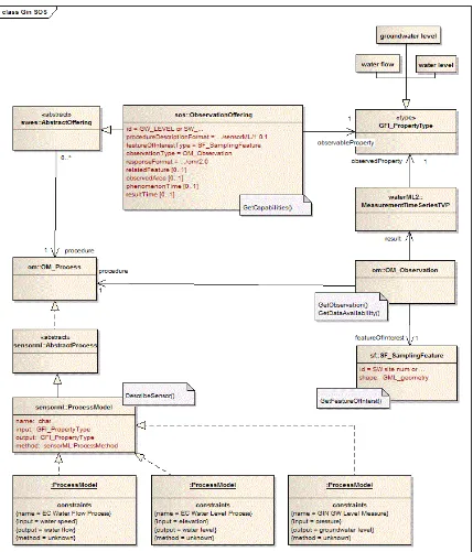
4.1 Introduction
This clause describes a profile of SOS 2.0 (see OGC 12-006) developed by NRCan and used in the CHISP-1 project as an interoperable baseline of capabilities.
The profile is named “The NRCan Profile of SOS 2.0 for CHISP-1” but is typically referred to as the “NRCan profile” or the “NRCan profile of SOS” in this document. All SOS’s deployed in the CHISP-1 project were implemented or were modified to conform to this profile.
4.2 UML model
Figure 1 illustrates the UML model that describes the NRCan profile. The main features of the profile as implemented for the CHISP-1 project are:
1. The service shall implement the GetCapabilities, DescribeSensor,
GetObservations, GetFeatureOfInterest and GetDataAvailability operations. 2. The service shall support the spatial filtering profile.
3. The service shall support the BBOX operator for the KVP binding (see http://www.opengis.net/spec/SOS/2.0/req/kvp-core/go-bbox-encoding, requirement 116).
4. The service shall implement WaterML 2.0.
5. For the GetDataAvailability operation, the “offering” parameter shall be mandatory.
6. The feature of interest shall be a SamplingFeature.
4.3 Sequence diagrams
4.3.1 Introduction
The following sequence diagrams illustrates how to obtain a time series for a specific feature of interest and also illustrates the Harvester algorithm (see 4.3.3) used to obtain the last observed value for a procedure, which is loaded into the system catalogue. 4.3.2 Retrieving a time series
The following sequence diagram (see Figure 2) illustrates how to retrieve a time series from an SOS that is compliant with the NRCan profile.
Figure 2 – Sequence diagram for fetching a time series
4.3.3 Harvester algorithm
The following sequence diagram illustrates the harvesting algorithm that is used to populate the catalogue with the last observed value of an observable.
The metadata that needs to be gathered by the harvester and stored in the catalogue includes the URL of the sensor observation service, the feature of interest, the observable, its last value and the timestamp.
18 The harvester module uses the GetCapabilities request to determine the available
observables and their extents (observedArea).
Using a GetFeatureOfInterest request, the harvester gets all the features of interest (using a BBOX) over the entire AOI.
For each returned feature of interest, the GetDataAvailability request is used to determine the parameter values necessary to formulate a GetObservation request to read the last value.
The GetObservation request is executed to extract the last value.
The last value is stored in the catalogue along with the URL of the service, the FOI, the observable, the last value and a timestamp.
Figure 3 – Sequence diagram for the harvester algorithm
4.3.4 SOS operations
4.3.4.1 Introduction
This clause discusses the features of the NRCan profile by using example SOS requests, encoded using both KVP and XML.
4.3.4.2 GetCapabilities
The following request causes a compliant SOS to generate service metadata in the form of an OGC capabilities document:
http://ngwd-bdnes.cits.nrcan.gc.ca:8080/proxy/GinService/sos/gw?REQUEST=GetCapabilities&SERVICE=SOS&VERSION=2.0.0
The salient portion of the response is presented here and illustrates the profile directives that a SOS compliant with the NRCan profile would include in its capabilities document: <ows:Profile>http://www.opengis.net/spec/SOS/2.0/conf/gfoi</ows:Profile>
<!-- TODO: add KVP BBOX profile when implemented -->
<!-- Observation can be queries using spatial geometry expressed in param --></pre> <ows:Profile>http://www.opengis.net/spec/SOS/2.0/conf/spatialFilteringProfile</ows:Profil e>
<!-- sampling feature must have a point geometry -->
<ows:Profile>http://www.opengis.net/spec/OMXML/2.0/conf/samplingPoint</ows:Profile>
<!-- Observation encoded with GML 3.2 XML-->
<ows:Profile>http://www.opengis.net/spec/OMXML/2.0/conf/observation</ows:Profile>
<!-- this service implement WaterML 2.0 -->
<ows:Profile>http://www.opengis.net/spec/waterml/2.0/conf/xsd-measurement-timeseries-tvp-observation</ows:Profile>
4.3.4.3 DescribeSensor
The following two examples encode the same DescribeSensor request -- one using the KVP encoding and the other using the XML encoding.
KVP-encoded example:
20 xmlns:swes="http://www.opengis.net/swes/2.0"
xmlns:xlink="http://www.w3.org/1999/xlink">
<procedure>urn:ogc:object:Sensor::EC_WaterLevelProcess</procedure> <procedureDescriptionFormat>http://www.opengis.net/sensorML/1.0.1</proc edureDescriptionFormat>
</swes:DescribeSensor>
4.3.4.4 GetFeatureOfInterest
The following KVP-encoded request illustrates a GetFeatureOfInterest request employing a BBOX spatial filter:
http://198.103.103.7/GinService/sos?REQUEST=GetFeatureOfInterest&VERSION=2.0.
0&SERVICE=SOS&spatialFilter=om:featureOfInterest/*/sams:shape,-101.2,49,-99.5,50.1&namespaces=xmlns(sams,http://www.opengis.net/samplingSpatial/2.0),xmlns( om,http://www.opengis.net/om/2.0
This following XML-encoded request similarly includes a spatial predicate on the GetFeatureOfInterest request:
<sos:GetFeatureOfInterest service="SOS"
version="2.0.0"
xmlns:sos="http://www.opengis.net/sos/2.0" xmlns:fes="http://www.opengis.net/fes/2.0" xmlns:gml="http://www.opengis.net/gml/3.2"
xmlns:sams="http://www.opengis.net/spatialSampling/2.0"> <sos:spatialFilter>
<fes:Intersects>
<fes:ValueReference>sams:shape</fes:ValueReference> <gml:Envelope srsName="urn:ogc:def:crs:EPSG::4326"> <gml:lowerCorner>49 -140</gml:lowerCorner>
<gml:upperCorner>60 -110</gml:upperCorner> </gml:Envelope>
</fes:Intersects> </sos:spatialFilter> </sos:GetFeatureOfInterest>
Finally, the following KVP-encoded request illustrates a GetFeatureOfInterest request employing an identifier to retrieve a specific feature of interest:
http://198.103.103.7/GinService/sos?REQUEST=GetFeatureOfInterest&VERSION=2.0. 0&SERVICE=SOS&featureOfInterest=ca.gc.ec.station.11AA001
4.3.4.5 GetObservation
The following KVP and XML encoding examples encode the same request: KVP-encoded example:
RVICE=SOS&offering=WATER_LEVEL&featureOfInterest=ca.gc.ec.station.05NG021
xmlns:sos="http://www.opengis.net/sos/2.0" xmlns:fes="http://www.opengis.net/fes/2.0" xmlns:gml="http://www.opengis.net/gml/3.2" xmlns:swe="http://www.opengis.net/swe/2.0" xmlns:swes="http://www.opengis.net/swes/2.0" xmlns:xlink="http://www.w3.org/1999/xlink"
xmlns:xsi="http://www.w3.org/2001/XMLSchema-instance" xsi:schemaLocation="http://www.opengis.net/sos/2.0
http://schemas.opengis.net/sos/2.0/sos.xsd http://www.opengis.net/gml/3.2
http://schemas.opengis.net/gml/3.2.1/gml.xsd"> <sos:offering>WATER_LEVEL</sos:offering>
<sos:observedProperty>urn:ogc:def:phenomenon:OGC:1.0.30:waterlevel</sos
For the NRCan profile is it mandatory to implement the GetDataAvailability request that plays an important role in this project because it provides the means by which the last value of a procedure can be monitored by the notification system.
This clause discusses various aspects of the GetDataAvailabilty operation including why the profile makes the offering parameter mandatory and how to use the operation to extract the last value.
4.3.4.6.2 Offering parameter
For CHISP, it is proposed that the offering be a mandatory item in the request. The reason for this is illustrated in the following example:
The NRCan SOS service (see 5.3.3.2) provides the same observed property and
procedure in two different offerings, WATER_FLOW and WATER_FLOW_LIVE. The only difference between them is the time span and the features of interest.
22 WATER_FLOW_LIVE has only 10 features of interest and values from around
2011 to now
Observed property : water flow
("urn:ogc:def:phenomenon:OGC:1.0.30:waterflow") procedure : Water flow process
("urn:ogc:object:Sensor::EC_WaterFlowProcess")
Offering: WATER_FLOW
WATER FLOW has historical data for a large number of features of interest, including the 10 present in LIVE, but the observation are all BEFORE 2011. Observed property : water flow
("urn:ogc:def:phenomenon:OGC:1.0.30:waterflow") procedure : Water flow process
("urn:ogc:object:Sensor::EC_WaterFlowProcess")
Because some features of interest actually appear in both offerings (05NB036 is an example), a GetDataAvailability response will be ambiguous if the request does not specify an offering (the service considers all offerings to be in scope - WATER_FLOW and WATER_FLOW_LIVE). This might further encourage the omission of an offering from an SOS GetObservation request, which could result in only one value returned instead of two.
Although not clearly stated in the SOS specification (see OGC 12-006), the time span should probably be an aggregation of both time spans from both offerings.
4.3.4.6.3 Extracting the last value
This clause discusses how the GetDataAvailability operation may be used to determine the request parameters for a GetObservation request that may be used to extract the last observed value for an offering of a feature of interest.
Consider the following KVP-encoded request is an example of the GetDataAvailability operation.
The GetDataAvailability operation can includes parameters to specify a procedure, an observation, a feature of interest, the offering and a time range. By default, if a value is not specified for a parameter, then the entire range of values for that parameter is included in the response.
Consider the following example which is requesting all procedures and observations related to feature of interest 05NB036 for offering WATER_FLOW_LIVE during 1900-01-01T12:00:00 to 2013-12-12T23:59:59.
o procedure = ? (response will include all matching procedures) o observation = ? (response will include all matching observations) o featureOfInterest = 05NB036
o offering = WATER_FLOW_LIVE
o time range = 1900-01-01T12:00:00 to 2013-12-12T23:59:59 Because we did not specify an observed property or a procedure in the request, the
response will return all observed properties and procedures in the context of that offering, feature of interest and time span. Here is the request encoded as XML:
<gda:GetDataAvailability version="2.0.0"
service="SOS"
xmlns:gml="http://www.opengis.net/gml/3.2" xmlns:gda="http://www.opengis.net/sosgda/1.0"
xmlns:xsi="http://www.w3.org/2001/XMLSchema-instance"
xsi:schemaLocation="http://www.opengis.net/sosgda/1.0
file:///W:/LCNP/Normes/SOS/SOS2/GetDataAvailability_Extension/xsd/sosGe tDataAvailability.xsd">
<gda:availabilityTimeframe> <gml:TimePeriod gml:id="x">
<gml:beginPosition>1900-01-01T12:00:00</gml:beginPosition> <gml:endPosition>2013-12-12T23:59:59</gml:endPosition> </gml:TimePeriod>
</gda:availabilityTimeframe>
<gda:featureOfInterest>05NB036</gda:featureOfInterest> <gda:offering>WATER_FLOW_LIVE</gda:offering>
</gda:GetDataAvailability>
Notice, that as per the NRCan profile the request includes a mandatory offering. A minimal response to this request might be:
<?xml version="1.0" encoding="UTF-8"?> <gda:GetDataAvailabilityResponse
24 xmlns:xsi="http://www.w3.org/2001/XMLSchema-instance"
xsi:schemaLocation="http://www.opengis.net/sosgda/1.0
file:///W:/LCNP/Normes/SOS/SOS2/GetDataAvailability_Extension/xsd/sosGe tDataAvailability.xsd">
<gda:featurePropertyRelationship>
<gda:FeaturePropertyTemporalRelationship
xmlns:gml="http://www.opengis.net/gml/3.2"> <gda:phenomenonTime>
<gml:TimePeriod gml:id="x1"> <gml:beginPosition>2011-05-15T23:16:00</gml:beginPosition>
<gml:endPosition>2013-01-14T14:00:00</gml:endPosition> </gml:TimePeriod>
</gda:phenomenonTime>
<gda:targetFeature xlink:href="#foi_05NB036"/> <gda:targetProperty xlink:href="#water_flow"/> </gda:FeaturePropertyTemporalRelationship>
</gda:featurePropertyRelationship> <gda:propertyEntryPoint>
<gda:ObservedPropertyInfo swes:id="water_flow">
<gda:property>"urn:ogc:def:phenomenon:OGC:1.0.30:waterflow"</gda:proper ty>
</gda:ObservedPropertyInfo> </gda:propertyEntryPoint>
<gda:featureOfInterestEntryPoint>
<gda:FeatureOfInterestInfo swes:id="foi_05NB036"> <gda:feature>05NB036</gda:feature>
<gda:relatedProperty xlink:href="#water_flow"/> </gda:FeatureOfInterestInfo>
</gda:featureOfInterestEntryPoint> </gda:GetDataAvailabilityResponse>
The salient fragment from this response is:
<gda:FeaturePropertyTemporalRelationship
xmlns:gml="http://www.opengis.net/gml/3.2"> <gda:phenomenonTime>
<gml:TimePeriod gml:id="x1">
<gml:beginPosition>2011-05-15T23:16:00</gml:beginPosition> <gml:endPosition>2013-01-14T14:00:00</gml:endPosition> </gml:TimePeriod>
</gda:phenomenonTime>
<gda:targetFeature xlink:href="#foi_05NB036"/> <gda:targetProperty xlink:href="#water_flow"/> </gda:FeaturePropertyTemporalRelationship>
1. Because we know the time period from the fragment above, we now have all the information necessary to formulate a GetObservation request to obtain the last value.
2. Alternatively, we could take advantage of the fact that the specification for the GetDataAvailability operation supports an extension point that could be exploited to allow us to include the last value in question in the response above without forcing a second request from the client application as proposed by
option (1).
In order to avoid the use of an extension point in an ad-hoc manner the NRCan profile proposed to use the first method (i.e. formulate a GetObservation request).
5. Use cases
5.1 Introduction
Two use cases were developed in the initial stages of the CHISP-1 project that were used to drive the development of the system architecture and ultimately the components developed by the project participants. The first use case was a flood event use case. The second use case was a nutrient load calculation use case. This clause describes these use cases as they ultimately manifested themselves during the course of the CHISP-1 project and were present at the final webinar.
5.2 Project participants
5.2.1 Introduction
This clause lists the CHISP-1 project sponsors and participants.
5.2.2 Sponsors
The CHISP-1 project was sponsored by the following organizations: Environment Canada
Natural Resources Canada (NRCan) GeoConnections
26 Environmental Protection Agency (EPA)
National Oceanic and Atmospheric Administration (NOAA)
In addition to sponsoring the project, Environment Canada, NRCan and USGS
participated in the project by enhancing their offerings to conform to the NRCan profile (see Clause 4).
5.2.3 Participants
The following organizations were projects participants responsible for the bulk of the new components developed during the CHISP-1 project (see Table 2, Table 4):
Explorus (http://www.explorus.org) GIS.FCU (http://www.gis.tw/En/) RPS ASA (http://www.asascience.com/)
5.3 Flood event and notification use case
5.3.1 Introduction
The flood event and notification use case focuses on monitoring cross-border stream flow and groundwater levels in order to detect when a potential flood event may be occurring. When a potential flood event is detected a unified alert service is used to notify EM analysts who have subscribed with the system to be notified of such events.
The use case can be broken down into three activities:
1. An on-going monitoring activity where the system periodically monitors stream and ground water gauges and tracks water flow and water level values.
2. A subscription activity where an emergency management analyst indicates his/her desire to be notified of an event of interest – such as an imminent flood – by choosing a monitoring point and specifying threshold parameters that signal the beginning of a potential flood. The event notification system automatically subscribes the EM analyst to monitor all the stations upstream of the specified point on interest.
3. A notification activity where the system checks the monitored values from
This clause described the components used and the basic course of action for each of these activities as developed during the CHISP-1 project.
5.3.2 Area of interest
Two basins with potions in both the U.S. and Canada were considered as areas of interest for the CHISP-1 project.
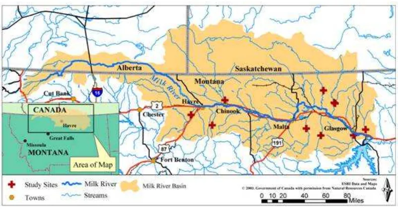
Milk River Basin:
The Milk River basin includes parts of Alberta, Saskatchewan, and Montana (see Figure 4).
Figure 4 – Milk River Basin
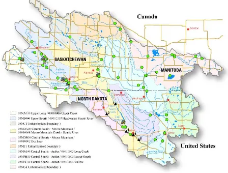
Source: http://www.umt.edu/watershedclinic/images/clip_image002.jpg Souris River Basin:
28 Figure 5 – Souris River Basin
Source: http://nd.water.usgs.gov/floodinfo/souris.html
The available data for both river basins was inspected to find a suitable historical flood event that could be used to drive component developed in CHISP-1 and that could also be used for the demo at the end of the project. The chosen event was the 2011 flood on the Milk River that occurred in the months of April and May.
5.3.3 Components
5.3.3.1 Introduction
It should be noted that some of the pre-existing SOS components were modified during the course of the CHISP-1 project to conform to the NRCan profile (see Clause 4) .
5.3.3.2 Pre-existing components
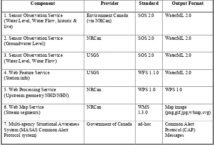
Table 1 lists the components for the flood event and notification use case that already existed at the start of project.
The table lists the name of the component and what kinds of information it provides, the organization providing the component, the standard to which the API of the component conforms and the standard to which the output format provided by the component conforms.
Table 1 – Pre-existing components for the flood event and notification use case
Component Provider Standard Output Format
1. Sensor Observation Service (Water Level, Water Flow, historic & live)
Environment Canada (via NRCan)
SOS 2.0 WaterML 2.0
2. Sensor Observation Service (Groundwater Level)
NRCan SOS 2.0 WaterML 2.0
3. Sensor Observation Service (Water Level, Water Flow)
USGS SOS 2.0 WaterML 2.0
4. Web Feature Service (Station info)
USGS WFS 1.1.0 WaterML 2.0
5. Web Processing Service (Upstream geometry NHD/NHN) 7. Multi-agency Situational Awareness
System (MASAS Common Alert Protocol system)
Government of Canada ad-hoc Common Alert Protocol (CAP) Messages
5.3.3.3 Components developed during CHISP-1
30 The table lists the name of each component and brief statement about what the
component does and/or what kind of information it provides, the organization providing the component, the standard to which the API of the component conforms and the standard to which the output format provided by the component conforms.
Table 2 -
Components developed during CHISP-1 for the flood event and notification use case
Component Provider Standard Output Format
1. Web-based subscription client (Subscribe to upstream stations)
Explorus N/A N/A
2. Event Notification Service
(Monitor stations, flood even notification)
GIS.FCU N/A N/A
3. Web Notification Service (Does notifications to subscribers)
GIS.FCU WNS 0.0.9 email
4. Web Processing Service (Upstream stations/gauges)
ASA WPS 1.0 WPS1.0
5. Catalogue
(Service metadata, Station metadata)
Explorus
The event notification service, Component 2 in Table 2, is composed of the sub-components:
A harvester module that monitors upstream stations and gauges. This component is also referred to as the “harvester” in this document.
A subscription broker that handles subscriptions and checks whether notification is required. This component is also referred to as the “broker” in this document. An OGC compliant web notification service (see Table 2, Component 3) that
performs the notification to subscribers.
5.3.4 Basic course of action
5.3.4.1 Introduction
1. An ongoing monitoring action where the system periodically monitors stream and ground water gauges and tracks their last value.
2. A subscription action where an emergency management analyst indicates his/her desire to be notified of an event of interest – such as a flood – by choosing a monitoring point, specifying event threshold parameters and having the system automatically subscribe to all the stations upstream of the specified point of interest.
3. A notification action where the system checks the monitored values from activity (1) against thresholds specified in activity (2) to determine if a flood is imminent and notification is required.
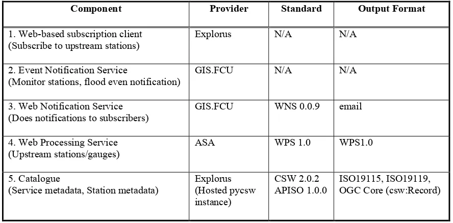
5.3.4.2 Monitoring action
The following course of actions, as illustrated in Figure 6, is performed by the event notification system to monitor the last observed value for gauges on the network. Each numbered item in this list corresponds to a circled number in Figure 6.
1. The harvester periodically reads the last observed value from gauges on the network.
2. The harvester stores these values as part of the metadata maintained in the CSW (see Table 2, Component 5) for each station.
3. Whenever the harvester reads a value that has changed it notifies the broker of the change.
4. This causes the broker to read the changed value from the CSW (see Table 2, Component 5).
32 Figure 6 – Basic course of action for the monitoring activity
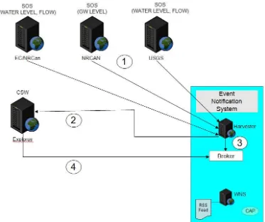
5.3.4.3 Subscription activity
The following course of actions, as illustrated in Figure 7, is performed by the event notification system to register a subscription for an emergency management analyst. The subscription indicates to the system that the analyst is interested in being notified of an imminent flood at a point of interest. Each numbered item in this list corresponds to a circled number in Figure 7.
1. An emergency manager analyst uses the web client to show water monitoring stations on a map. Figure 17 is a detailed example of such a map.
2. The analyst chooses a station or monitoring point of interest.
4. The broker then registers the subscription with the WNS.
Figure 7 – Subscription action
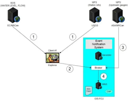
5.3.4.4 Notification action
The following course of actions, as illustrated in Figure 8, is performed by the event notification system to determine if an event of interest has occurred and if it has to notify subscribers. Each numbered item in the list bellow corresponds to a circled number in Figure 8.
34 executed during the pilot.
The notification action proceeds as follows:
1. When notified by the harvester (see 5.3.4.2), the broker reads the last value from the CSW.
2. If the value violates a subscription threshold (e.g. the water level has risen above a set threshold) the broker creates a notification email.
3. The event notification system uses the WNS to do the notification.
4. The WNS sends the notification email created in step 2 to the EM analyst. 5. Among other things, the notification email includes a link to invoke a CAP Alert 6. The EM analyst can click the CAP Alert link which brings up a dialogue box to
create the alert (see Figure 10).
7. The alert is then sent to the MASAS hub which is responsible for distributing the alert.
Figure 9 is a sample of a notification email generated by the event notification system and sent to subscribers by the WNS when an event of interest occurs. The email includes
Metadata about the subscription A map showing the station locations
o the status of each station in indicated by color
o blue indicates that the last observed values from the corresponding station has not exceeded subscription thresholds
o red indicates that the last observed value from the corresponding station has exceeded subscription threshold
A table listing all the upstream stations. The table includes the station id, the last measured values for water level, water flow and ground water level and the time the value was read. Any stations whose measured values exceed the specified subscription thresholds are highlighted in red in the table.
36 Figure 9 – Notification email
Figure 10 – MASAS posting tool
5.4 Nutrient load calculation use case
5.4.1 Introduction
The Nutrient Load Calculation use case computes known nutrient loads to the Great Lakes from tributaries, using web-accessible inputs of water quality observations and flow rates, to produce web-accessible outputs of nutrient loads. The use case focuses on the analytes Phosphorus and Nitrogen.
5.4.2 Components
5.4.2.1 Pre-existing components
Table 3 lists the components for the nutrient load calculation use case that already existed at the start of the CHISP-1 project.
The table lists the name of the component and what kinds of information it provides, the organization providing the component, the standard to which the API of the component conforms and the standard to which the output format provided by the component conforms.
38
Component Provider API
Standard
Output Format Standard 1. Sensor Observation Service
(Water Level, Water Flow, historic & live)
Environment Canada (via NRCan)
SOS 2.0 WaterML V2.0
2. Sensor Observation Service (Water Level, Water Flow)
USGS SOS 2.0 WaterML V2.0
5.4.2.2 Components developed during CHISP-1
Table 4 lists the components for the flood event and notification use case that were developed and deployed during the CHISP-1 project.
The table lists the name of each component and brief statement about what the
component does and/or what kind of information it provides, the organization providing the component, the standard to which the API of the component conforms and the standard to which the output format provided by the component conforms.
Table 4 – Components developed during CHISP-1 for the nutrient load calculation use case
Component Provider API Standard Output Format
Standard 1. Web Processing Service
(Nutrient load calculation)
ASA WPS 1.0 WPS 1.0
2. Sensor Observation Service
(Integrates US and CAN water quality servers)
ASA SOS 2.0 IOOS SWE
XML
3. Nutrient Load Calculation Web Client ASA N/A N/A
4. Local catalogue
(Catalogue of streams, tributaries and water quality gauges)
ASA Django Database Abstraction API
N/A
5. SPARQL Server
(Analyte equivalents US, CAN)
NRCan SPARQL RDF
5.4.3 Basic course of action
1. A WQA initiates the nutrient load calculation web client and provides these inputs: a Great Lake of interest, the name of an analyte, a time period of interest 2. The web client invokes the nutrient load calculation WPS to run the model. 3. The nutrient load calculation WPS queries the local catalog for tributaries on the
lake of interest that have both a stream gauge and water quality samples available for the nutrient of interest.
4. For the stations returned by the catalogue query, the NLCS makes requests to the water quality and stream flow SOS services
5. The nutrient load calculation WPS interpolates the water quality and stream flow measurements for the period specified by the request. It calculates nutrient flux from the interpolated measurements and numerically integrates the results to determine the total load over the period of interest for each tributary
6. It sums all of the tributaries' contributions for the total load on the lake
(converting units between standard and SI where appropriate) ... and presents the results to the WQA
40 6. Component details
6.1 Upstream WPS
6.1.1 Introduction
The function of the upstream WPS is, given a point of interest, to determine which water monitoring stations or gauges exist upstream of that point.
6.1.2 Service endpoint
The service endpoint for the upstream WPS can be found at:
http://64.72.74.103:8080/wps/?request=GetCapabilities&version=1.0.0
6.1.3 Implementation details
The upstream WPS was implemented in Python using a custom developed WPS framework for flexibility and depends on the following libraries:
For scientific computing: numpy (http://www.numpy.org) Web framework: django (http://www.djangoproject.com)
For making HTTP requests: requests (http://docs.python-requests.org) A python-based HTTP server: gunicorn (http://www.gunicorn.org)
o was used as a WSGI server for the service 6.1.4 Operational details
6.1.4.1 Introduction
The upstream WPS service implements the following operations: GetCapabilities, DescribeProcess and Execute.
The upstream WPS offers the following methods or processes: add_gauge_to_stream, remove_gauge_to_stream and find_upstream_gauges.
6.1.4.2 Process add_gauge_to_stream
The process accepts as input a list of gauge id’s and a river reach identifier (in the Canadian NHN ID format) and then updates its local database with the relationship. The response is either an acknowledgement that the relationship was successfully registered or an exception message.
6.1.4.3 Process remove_gauge_from_stream
The remove_gauge_from_stream process removes the relationship between a list of gauges and a river segment.
The process accepts as input a list of gauge id’s and a river reach identifier (in the Canadian NHN ID format) and then removes the relations from the local database. The response is either an acknowledgement that the relationship was successfully removed or an exception message.
6.1.4.4 Process find_upstream_gauges
Give a point of interest, the find_upstream_gauges process finds all the gauges upstream of that point.
The find_upstream_gauges process queries the NRCan upstream river segment WPS (see Table 1, Component 5) and based on the river segments, returns the stream gauge id’s that are located on those rivers segments (if any exist).
The find_upstream_gauges process then uses a local database to manage the river/gauge relationships – originally provided by the sponsors as an Excel spread sheet – via
django’s database abstraction API.
The response from the find_upstream_gauges process is an XML document that encodes the stream id/gauge id relationships. The following XML fragment is an example of a response to the find_upstream_gauges process:
<Stream>
<id>7bb9c0305c7f4802956c8f7277819f7e</id> <name>Souris River</name>
<Stations>
<Station latitude="49.9888916"
longitude="-104.19000244">ca.gc.ec.station.05NB031</Station> </Stations>
</Stream> <Stream>
<id>64744610f8e74928890282eafe7f73ad</id> <name>Souris River</name>
<Stations>
42 longitude="-103.54110718">ca.gc.ec.station.05NB037</Station> </Stations>
</Stream> <Stream>
<id>50633f5b9f7e425786545276de3bec58</id> <name>Souris River</name>
<Stations>
<Station latitude="49.49361038"
longitude="-103.66221619">ca.gc.ec.station.05NB017</Station> </Stations>
</Stream> <Stream>
<id>2876fe821ae34b49a0d91428a5ebd308</id> <name>Souris River</name>
<Stations>
<Station latitude="49.57556152"
longitude="-103.76889038">ca.gc.ec.station.05NB020</Station> </Stations>
</Stream> <Stream>
<id>42ddf48f83fe47e49ac8aaf1da906f5b</id> <name>None</name>
<Stations>
<Station latitude="49.5616684"
longitude="-103.67443848">ca.gc.ec.station.05NB024</Station> </Stations>
</Stream> <Stream>
<id>a536171eecbf4d66afc93629df2488dc</id> <name>Souris River</name>
<Stations>
<Station latitude="48.9963913"
longitude="-100.95806122">ca.gc.ec.station.05NF012</Station> <Station latitude="48.9964079"
longitude="-100.9584889">05124000</Station> </Stations>
o http://64.72.74.103:8080/wps/?service=WPS&version=1.0.0&request=exe cute&identifier=find_upstream_gauges&datainputs=latitude=49.37833023 %3Blongitude=-100.78943634
o http://64.72.74.103:8080/wps/?service=WPS&version=1.0.0&request=exe cute&identifier=find_upstream_gauges&datainputs=latitude=49.1448%3B longitude=-112.0769
6.2 Catalogue
6.2.1 Introduction
The catalogue deployed for the CHISP-1 project was used to store metadata about servers participating in the project and metadata about water monitoring stations. The primary function of the catalogue within the CHISP-1 project was to support dynamic discovery of the registered components by other components participating in the project. For example, the harvester module (see 6.3.4.1) of the event notification system uses the CSW to discover the available sensor observation services to monitor and also updates the station metadata stored in the CSW to store the last observed value for each offering. 6.2.2 Service endpoint
The service endpoint for the catalogue can be found at:
http://107.22.84.193/pycsw/csw.py?service=CSW&version=2.0.2&request=GetCapabiliti es
6.2.3 Implementation details
The initial deployment of the catalogue used the GeoNetwork catalogue (see
http://sourceforge.net/projects/geonetwork/). However, several issues were encountered that forced the project to seek an alternative catalogue.
The specific issues encountered using the GeoNetwork catalogue included:
1. A number of documented and undocumented bugs were encountered that consumed a significant amount of project resource to try and resolve. Eventually a properly configured CSW service was deployed as described in the GeoNetwork documentation.
44 3. The catalogue did not implement the CSW Harvest operation1 which allows
services to be easily registered. The lack of this operation would require a much more involved and likely manual process to register each service in the project.
NOTE 1: The CSW Harvest operation should not be confused with the Harvester module of the event notification system (see 6.3.4.1). The CSW Harvest operation allows the catalogue to read resource metadata (such as the capabilities document of an OGC service) and register the resource to make it discoverable. The Harvest module, on the other hand, is the sub-component of the event notification system that reads the last observed value from a monitoring station and stored that value in the catalogue (see 6.2).
As a result of these issues, the pycsw (see http://pycsw.org/) catalogue was chosen to replace the GeoNetwork catalogue. The pycsw catalogue is an OGC CSW (see OGC 07-006r1) server implementation written in Python and is certified OGC Compliant. The pycsw server offered the following capabilities:
1. The server provided a stable CSW with transactional support that the project required.
2. The pycsw catalogue supports a number of profiles of the OGC CSW but for the CHISP-1 project, the ISO application profile (see OGC 07-045) was selected. 3. The server supports the Harvest operation; although the operations did not
initially support harvesting OGC sensor observation service (see item 4 below). 4. One of the primary implementers of pycsw was part of the sponsor team from
Environment Canada which allowed any issues encountered to be addressed quickly and which also allowed the pycsw to be extended to suite the
requirements of the project (see 6.3.4). Enhancements:
The pycsw catalogue supports the ability to register many OGC compliant services by reading their capabilities document and then automatically registering the service (e.g. WFS, WMS, WCS, etc.). This is accomplished using the CSW Harvest operation. The pycsw catalogue, however, did not support registering OGC sensor observation services (see OGC 12-006) in this way.
To resolve this issue, the pycsw source code was extended to add the ability to use the Harvest operation to register OGC sensor observation services. These changes were checked back into the pycsw code base maintained on GitHub (see
https://github.com/geopython/pycsw). 6.2.4 Operational details
Register CHISP-1 services into the catalogue to make them discoverable. Register the available water monitoring stations to make then discoverable. Use the CSW to get the list of services and stations within the AOI.
Periodically update the water monitoring station metadata to include the last observed value.
The examples in Clause 6.2.6 illustrate CSW requests that perform each of these activities.
6.2.5 Examples
Example 1: Register a sensor observation service with the CSW <?xml version="1.0" encoding="UTF-8"?>
<Harvest
xmlns="http://www.opengis.net/cat/csw/2.0.2" xmlns:ogc="http://www.opengis.net/ogc"
xmlns:gmd="http://www.isotc211.org/2005/gmd" xmlns:ows="http://www.opengis.net/ows"
xmlns:xsd="http://www.w3.org/2001/XMLSchema" xmlns:dc="http://purl.org/dc/elements/1.1/" xmlns:dct="http://purl.org/dc/terms/"
xmlns:gml="http://www.opengis.net/gml"
xmlns:xsi="http://www.w3.org/2001/XMLSchema-instance" xsi:schemaLocation="http://www.opengis.net/cat/csw/2.0.2 http://schemas.opengis.net/csw/2.0.2/CSW-publication.xsd" service="CSW"
version="2.0.2">
<Source>http://ngwd-bdnes.cits.nrcan.gc.ca/GinService/sos?SERVICE=SOS&REQUEST=GetCapabiliti es</Source>
<ResourceType>http://www.opengis.net/sos/2.0</ResourceType> <ResourceFormat>application/xml</ResourceFormat>
</Harvest>
Example 2: Register a water monitoring station <?xml version="1.0" encoding="UTF-8"?> <csw:Transaction
xmlns:csw="http://www.opengis.net/cat/csw/2.0.2" xmlns:dc="http://purl.org/dc/elements/1.1/" xmlns:dct="http://purl.org/dc/terms/"
xmlns:ows="http://www.opengis.net/ows"
46 version="2.0.2">
<csw:Insert> <csw:Record>
<dc:identifier>ca.gc.ec.station.05NB004</dc:identifier> <dc:title>BEAVERDAM CREEK NEAR WEYBURN</dc:title>
<dc:type>station</dc:type>
<dc:subject>offering:WATER_FLOW</dc:subject> <dc:subject>offering:WATER_LEVEL</dc:subject>
<dc:subject>observedProperty=urn:ogc:def:phenomenon:OGC:1.0.30:waterflo w</dc:subject>
<dc:subject>observedProperty=urn:ogc:def:phenomenon:OGC:1.0.30:waterlev el</dc:subject>
<dc:relation/>
<dct:modified>2013-02-20T16:10:00-08:00</dct:modified> <dct:abstract></dct:abstract>
<ows:WGS84BoundingBox>
<ows:LowerCorner>49.5972 -103.9652</ows:LowerCorner> <ows:UpperCorner>49.5972 -103.9652</ows:UpperCorner> </ows:WGS84BoundingBox>
</csw:Record> </csw:Insert> </csw:Transaction>
Example 3: Query to obtain the set of sensor observation services within the AOI <?xml version="1.0"?>
<GetRecords service="CSW" version="2.0.2" maxRecords="100" resultType="results"
xmlns="http://www.opengis.net/cat/csw/2.0.2" xmlns:csw="http://www.opengis.net/cat/csw/2.0.2" xmlns:fes="http://www.opengis.net/ogc"
xmlns:gmd="http://www.isotc211.org/2005/gmd"
xmlns:xsi="http://www.w3.org/2001/XMLSchema-instance" xsi:schemaLocation="http://www.opengis.net/cat/csw/2.0.2
http://schemas.opengis.net/csw/2.0.2/csw.xsd"> <Query typeNames="csw:Record">
<ElementSetName>full</ElementSetName> <Constraint version="1.0.0">
<gml:lowerCorner>48.25 -112.56</gml:lowerCorner>
Example 4: Update the metadata for a station to store the last value <?xml version="1.0" encoding="UTF-8"?>
<csw:Transaction
xmlns:csw="http://www.opengis.net/cat/csw/2.0.2" xmlns:fes="http://www.opengis.net/ogc"
xmlns:dc="http://purl.org/dc/elements/1.1/" xmlns:dct="http://purl.org/dc/terms/"
xmlns:ows="http://www.opengis.net/ows"
xmlns:xsi="http://www.w3.org/2001/XMLSchema-instance" xsi:schemaLocation="http://www.opengis.net/cat/csw/2.0.2 http://schemas.opengis.net/csw/2.0.2/CSW-publication.xsd" service="CSW" version="2.0.2">
<csw:Update>
<csw:RecordProperty>
<csw:Name>dct:abstract</csw:Name>
<csw:Value>type:water_flow;value:6.792</csw:Value> </csw:RecordProperty>
<csw:Constraint version="1.0.0"> <fes:Filter>
6.3 Event Notification Service
6.3.1 Introduction
48 The overall architecture of the event notification service is illustrated in Figure 12. The event notification system is composed of the following sub-components:
Harvester
Subscription Broker Notification service
The implementation and operational details of each component are described in this clause.
6.3.2 Service end points
6.3.2.1 Servers and control components
Harvester control program: https://github.com/gisfcuchisp1/DemoTool
Note: The Harvester control program allows the harvester to be invoked for a specific period of time thus allowing historical flood events to be demonstrated using the monitoring system developed for the CHISP-1 project.
Subscription broker: http://59.125.87.213/WNS/Broker/RegisterInfo.ashx Web Notification service: http://59.125.87.213/WNS/notification/wns.ashx
6.3.2.2 Test clients
The following components are not strictly part of the system developed for CHISP-1 but rather are test harnesses built to test various sub-components of the event notification server and the GetDataAvailability extensions built by GIS.FCU.
Broker API test client: http://59.125.87.213/wns/broker/testbroker.aspx Harvester test client: http://59.125.87.213/Harvester/Default.aspx
CAP test client: http://59.125.87.213/wns/broker/CAPAlertPosting/new_cap.aspx GetDataAvailability test client: http://59.125.87.213:443/sos-4.0.0/client
6.3.3 Implementation details
Harvester, Subscription Broker, Web Notification Service
Windows Server 2008 MS SQL Server 2008 NET Framework4.0.
CAP Alert Client
The MASAS Tool (https://sandbox2.masas-sics.ca/portal/main) was used for publishing to the MASAS HUB from the CAP Alert client (see 6.3.4.2.5).
GetDataAvailability operation
Version 4.0 of the 52North code was used to implement the SOS GDA operation that complied with the NRCan profile (see Clause 4). Documentation for 52North’s open source sensor observation service can be found at:
https://wiki.52north.org/bin/view/SensorWeb/SensorObservationServiceIVDocumentatio n). The development environment consisted of the following components:
Java runtime environment (JRE) 7.0 Tomcat7.0
50 Figure 12 – ENS architecture
6.3.4 Operational details
6.3.4.1 Harvester
In order for the event notification system to operate it must, for each subscription, read the last observed value and compare it to threshold values defined at the time the subscription was created. When the monitored value exceeds a defined threshold the system sends a notification of the event to each affected subscriber.
the last observed value from the cache and perform its threshold checks to determine if an event of interest has occurred.
For the CHISP-1 project, the initial implementation proposal for the last value cache was a lightweight REST-based service that used a JSON payload to encode the last value. This proposal however, was abandoned in favor of a more standards based approach using the OGC catalogue (see OGC 07-006r1). Since the catalogue was already being used to stored metadata about each water monitoring station (see 6.2.4), it was decided to simply add the last observed value as part of the metadata and the event notification service could simple access that value using the standard catalogue GetRecord request. The catalogue approach is a more heavyweight approach than the initially proposed REST-based caching service but it was decided to push the OGC technology and see if it could satisfy the requirements of the event notification system. For the CHISP-1