Integrated Sediment Related Disaster (Galodo) Management
87% of its area. It has 4 lakes, namely Lake Maninjau, Lake Diatas, Lake Dibawah and Lake Singkarak, and 600 rivers flowing to the west coast and the east coast of Sumatra island. West Sumatra lies on a tectonic plate between the encounter of two major continental plates, fracturing the Eurasian plate and Australia, 250 km to the west of the coastline, and large faults along the Bukit Barisan Sumatra. This province also has four active volcanoes, namely Talang, Tandikek, Merapi and Kerinci.Some studies reveal there are 58 rivers that are particularly vulnerable to the danger of debris flow. The last flood of debris flow (galodo) happened in West Sumatra, in headwaters of Limau Manis in Padang, in which the river headwaters in the western part of the Bukit Barisan. The river was steep and flows down the west coast of Sumatra (Indian Ocean). In July and September 2012, extraordinary floods in the Limau Manis river had destroyed about 3,000 hectares of irrigated area and damaged some infrastructure around the river. In addition, some units of residential and public facilities had been damaged by flood and four people died.
Restoration that has been done, namely dredging sediments, groundsill development and protection of riverbank is one of the post-flood emergency actions. Rehabilitation of public infrastructure, namely the improvement of irrigation system, the bridge has been built to create secure feeling to the community. Management process of debris flow in Limau Manis river has been carried out on the phases of disaster management, namely emergency response, recovery (rehabilitation and reconstruction), and mitigation for the next extraordinary disaster in the future.
Keywords: debris flow, sediment disaster, recovery
1) Paper presented at the Indonesia - Japan Sabo Workshop - Policy dialogue
BACKGROUND
West Sumatra has extensive land about 4:23 million hectares, or 2.17% of the total area of the Republic of Indonesia, more than 4.8 million people (West Sumatra Profile. 2010 [1]). The province is located between two major epicenters; the subduction zone of the Eurasian Plate and Indo-Australian Plate predicted located 250 km to the west of the coastline of Sumatra, Sumatra and major faults (faults Semangko) extending along the Bukit Barisan mountains. The province also has four active volcanoes: namely Merapi, Tandikat and Talang. This province has water resources of 600 rivers. Some of them disembogues down to the east coast and partly disembogues to western island of Sumatra. These streams are grouped into 5 basins with 4 great lakes: namely Maninjau, Singkarak, Diatas and Dibawah. West Sumatra has a territorial sea area of 186 500 km2 with a long coastline of 2,420 km, 375 large and small islands (Figure 1).
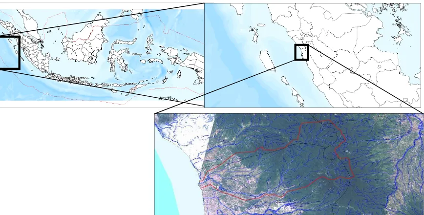
Figure 1. Location of Limau Manis River, Padang City, West Sumatra, Indonesia
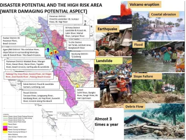
Figure 2. Potential natural disasters in West Sumatra Province
In accordance with the mandate of Constitution 1945 (UUD 1945) [2], that all citizens have the right to obtain protection for themselves and their families, dignity and honor, the responsibility of the state, and also have the right to get a sense of security and protection from fear to do something , the Indonesian government has issued Law of the Republic of Indonesia No. 24/2007 on Disaster management [3] to bring the constitutional mandate hazards associated with this disaster. It includes several integrated stages such as pre-disaster, during disaster and post-disaster that become an integral part of development plans at national, provincial and local levels. In addition to this legislation, there are several other laws concerned. Firstly the Law of the Republic of Indonesia No. 26/2007 on Spatial planning [4] which requires all spatial planning from the planning, utilization, management, control and supervision should be based on disaster mitigation plan in an effort to improve the safety of life and safety. Secondly, Republic Act No. 27/2007 on Coastal areas and small islands [5] has special chapter on disaster mitigation in coastal areas and small islands.
constitution in this province requires mitigation efforts to reduce the risk of disaster with concerted and well planned action. Integrated action means that it involves all people who are included in the overall disaster risk mitigation planning processes which are well planned. It incorporates the entire disaster management strategies in local development planning.
The condition of some rivers in West Sumatra with steep topography that is aggravated by climate change and geography hilly-mountainous and earthquake conditions creates a high risk of flood, debris flow and landslides. Disasters which occurred resulted in many human casualties and material.
Limau Manis River is tributary of Batang Kuranji that is one of the 23 rivers that flow in Padang city. This river has a watershed area (catchment area / CA) 694 960 hectares or equal to 1.65% of the area of the province. The length of Batang Kuranji River is 32.50 km and the width of the downstream is 60.00 m and flows from 1,400 m above sea level to its estuary at the Indian Ocean. It is a steep river, where 10.00 km in headwaters is sediment production area, 5.00 km in the middle is the transportation area and 17.50 km in the downstream is the sedimentation area. Flood and debris flow on 24 July 2012 and 12 September 2012 with the flood discharge of 1,045 m3 / sec as a result of high rainfall, fracture ground by an earthquake a few years ago, steep topography with critical land, water saturated soil, unstable riverside, and the use of land/area which reduces the capacity river flow. The Flood has caused several victims and damaged houses in Limau Manis river (Gunung Pangilun housing), damaging 4 units irrigation canal with a total area of 3,000 hectares, and also caused 95 houses damaged, 172 houses were damaged, 271 houses were slightly damaged, 2 educational facilities and 1 medical facilities, 15 mosques damaged, landslides which dumped 6 houses in the village of Batu Busuk upstream of Limau Manis and caused four died.
Emergency response that had been done included some structural and non-structural aspects in the sedimentation area. Yet it did not / had not been in the area of transportation and production sediment area.
Comprehensive flood management plan in Limau Manis river will soon be performed gradually with the government's priorities.
1. The flow of surface run-off (Source : Zahrul et.al)
occurs when intensity of rain exceeds the capacity soil infiltration, while flooding is one extreme form of surface runoff where the the level of river surface or the production of river canal (stream) exceeds the capacity of the river
Floods and droughts are natural phenomena where the stream systems are not able to absorb, reserve, and distribute the changes of rainfall. The systems to the emergence of peak flow and shorten the time to the peak flow (flood). The subsequent effect is an increase in groundwater during the rainy season which reduces production of water supply during the dry season. The used Rainfall data were taken from the rain station of Batu Busuk, Mount Nago and Ladang Padi rainfall stations located in CA Batang Kuranji.
Soil texture in CA based geo-morphological map of Padang, Sumatra sheet (Karnawan, et al., 2004) is generally in the form of sandy clay.
a. Measuring the water flow based on rainfall data.
One way to determine the cause of the debris flow is to estimate the water flow. A method that is widely used in Japan is the Rational Method. This method is very simple, easy and well-known among other empirical formula. The mathematical equation is
Q = 0.278 CIA;
Q is the peak discharge in m3 / sec; C is the runoff coefficient (0 ≤ C ≤ 1); I is the intensity of rainfall in mm / h, and A is the runoff area (km2). Coefficient C is defined as the ratio between runoff and rainfall intensity. This factor is the most important variable in measuring the flow of flood. The main factors affecting the coefficient C are the infiltration rate, slope, land vegetation cover, rainfall intensity, soil conditions and characteristics, groundwater, soil density, and soil porosity. The infiltration rate will be reduced if it rains for a long period of time and also be influenced by the previous rainfall. Based on the measurements, the flood flow that occurred in Limau Manis river was caused by rainfall of 319.37 m3 / sec.
b. Measuring the flood flow based on rainfall data.
The Data of water flow in the weir of Mount Nago (in Batang Kuranji) on July 24, 2012 when a debris flow occured, can be used as comparative data on water
flow measured by the rainfall data. The formula used is: Q = Cd 2/3 √2 / 3 gb H3
g = acceleration of gravity (9.81 m / s2); b = the peak width (m); H = height during the height (m).
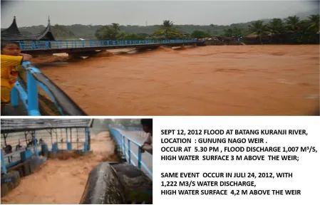
Based on the equation, the data flow in the flood dam of Mount Nago is 1,045 m3 / s (Figure 3).
Figure 3. Wier of Gunung Nago irrigates 3,000 hectares
2. Causes of debris flow (galodo)
Debris flow can be caused by heavy rains in CA which is in water saturated condition because of the previous precipitation, or CA has a poor absorption capacity and the runoff rapidly concentrate into the river channel. Because of rapid water flows and the flow of the runoff, debris flow brings rocks, mud from river bank erosion or sediment in the river, and tree stumps uprooted from its place that will sweep agricultural areas, bridges and houses in streams and affect multiple human casualties.
is blocked by debris flow material from the steep river that collapsed at the same time as the wood and tree stumps to the bottleneck of the river. Because of this natural dam damage, materials detained in upstream, such as wood, mud, and rocks will cause this debris to flow.
Formation of natural dam (natural dams).
Debris flow material in the form of mud, stone or wood logs will fall into the stream and will soon form a dam, or, the material carried by the water flow and stop/unobstructed in the narrow river will gradually form a dam
The cause of the collapse of the natural dam (Source : Report of the Technical Advice)
a. Overflow (overtopping): When water in the river is prevented by natural dam, the water level will gradually increase. Where the surface level has reached the top level of the dam, the water will overflow and simultaneously scrape the material forming a natural dam. Then the dam will finally collapse. The uncontrolled water flow will quickly flow and sweep existing materials (galodo).
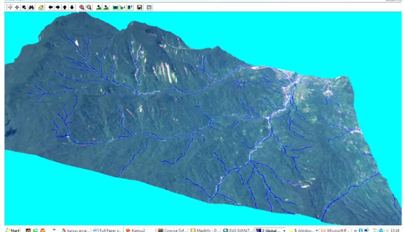
Figure 4. Landslide in Limau Manis upstream (Source : Zahrul et.al .: ALOS images September 2012)
3. Mechanisms and factors triggering debris flow
Flood with the speed level of 40 km/h is grouped into three schemes: 1) runoff caused by a stoppage in the bridge zone; 2) leap/runoff in the river flow; and 3) runoff caused by a decrease in river flow capacity caused by the deposition of sediments.
a. This runoff is caused by a stoppage in the bridge area. This usually occurs in the bridge area, where a stoppage caused by the bridge pillars and head bridges. During the flood the bridge will be clogged by some material, so that the flow will be shifted to the left and right of the bridge or out of the river channel. It also occurs in some bridges along the Limau Manis river.
b. There is Leap/runoff water flow in the river area which has changed/meadering. Leap of water flowing out of the groove usually occurs in meandering region. One of these phenomena occurs in upstream areas of Limau Manis
c. A decrease in river flow capacity due to deposition of sediments results in water runoff during large water discharge. This condition occurs in the sediment with < 3% slope.
DISASTER MANAGEMENT (Source : Bambang et.al.)
1. The non-structural measures. Disaster management needs to be done mainly is: mobilizing personnel from a variety of different elements to rescue and evacuate 500 victims; fulfill their basic needs in temporary shelters (relative/neighbors); providing clean water and sanitation facilities; and providing medical care to the wounded and unhealthy, especially for toddlers and the elderly during the emergency response established by the Mayor of Padang for one month.
2. The structural measures. Disaster management needs to be done to protect people around the river and to prevent the building over the river by the rehabilitating damaged irrigation systems around 3,000 hectares, water supply facilities, and bridge rehabilitation, and normalizating Limau Manis river such as dredging, strengthening edge river with beronjong stone wire, and building groundsill with beronjong wite in several important places and public facilities.
DISCUSSION
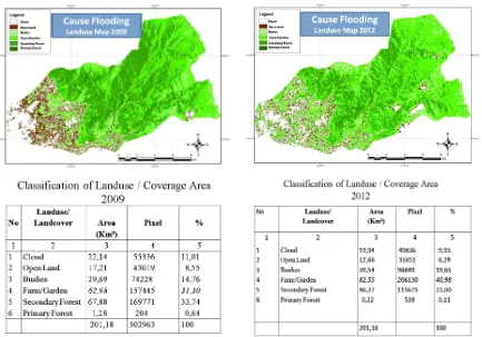
1. Classification of land use planning/coverage area
In 2009, open land (no plants) 17.21 km2; thicket 29.69 km2 (14.76%); farm fields 62.98 km2 (31.30%); secondary forests 67.88 km2 (33.74%); and forest plants of 1.28 km2 (0.64%). In 2012: open land 12.66 km2; thicket 39.54 km2 (6.29%); farm fields 82.55 km2 (40.98%); Secondary forests 46.27 km2 (23.00%); forest plants 0.22 km2 (0.11%).
Based on data from regional land use plan/coverage area, there is a decrease in secondary forest cover of 67.88 km2 in 2009 to 46.27 km2 in 2012, forest plants of 1.28 km2 in 2009 to 0.22 km2 in 2012, and the increasing amount farmland of 62.98 km2 to 82.55 km2 and and also increasing thicket of 29.69 km2 to 39.54 km2. By decreasing the amount of forest plans and secondary forest shift in farmland and thicket, has led to increase flow coefficient (C) and eventually will increase flood flow (Figure 6).
2.Water Container
Analysis of water containers showed that many puddles occured in CA Limau Manis. In 2009, the area of the water reservoir was 14 km2, and in 2012, it increased to 20 km2, which could be a puddle in the fields or in the natural pools of upstream CA. Because of this location, a container of water in the far Limau Manis upstream, most likely a container of water in a natural dam.
The flow of the floods on July 24, 2012: Based on the level of rainfall, flood flow calculation result is 319.37 m3/sec, while the water flow in the weir of Mount Nago on flood peak is 1,045 m3/sec, showing a diversity of 725.63 m3/sec. Debris flow calculation of flood flow is 675 m3/sec, while the water flowing stream in the weir Mount Nago at the flood peak is 631 m3/sec, (almost the same as the previous floodwaters in July 2012).
3.Potential sediment disasters
Based on both temporary observations and aero visual survey after the flood, surface water contains sediment which might impact the shear in the hills and the upstream section of Limau Manis. The posibility of repeated flooding will continue because of the high rainfall intensity and cracked ground caused by the previous earthquake. So that research and further studies should be carried out.
4. Based on the above analysis it is concluded that the debris flow on that date was caused by several factors:
a. There were some shifts in the primary and secondary functions of forests into agricultural land and thicket
b. Soil conditions were rough and shallow, unstable and cause landslides.
c. The high levels of rainfall in CA reached 165 mm (Batu Busuk station) for 6 hours.
e. saturation levels of soil were relatively sensitive to erosion after rain that occurred on the previous day.
f. Seismic events resulted in a gap in the upper hills of CA
g. The collapse of natural dam caused the inability of water to block the water flow.
h. Settlements in the river flow causes the flow to narrow and reduced the capacity of flood flow
5. Policies and strategies
a. Disaster management of debris flow that has been conducted includes emergency response and recovery. Emergency response is temporary and conducted in each area to protect people from the immediate impact of the disaster. This step includes fixing the morphology of the river to improve the river flow in order not to endanger the people around the river. The improvemet includes: scours around the bridge, shape alteration of the river flow, alteration of river width due to errosion, bridge construction, irrigation and other public infrastructure.
b. Management of sediment integrated disaster should be applied from upstream of Limau Manis to downstream of Batang Kuranji, both structural and non-structural. The control of debris flow in the form of structures is in the form of construction Sabo series with the following criteria:
1. Type of Slit-dam is a dam that is most suitable for sediment production area with 6% of slope watersheds.
2. Chek-dam or dam consolidation is the best dam in the sediment transportation area by slope watersheds between 3-6%.
3. Channel-works and flow control are the best options to maintain the stability of the river flow in the deposition area with a slope watershed lower than 3%.
RECOMMENDATION
1. It is necessary to conduct the integrated management of debris flow (from
of consolidation type, and for the deposition area applying boxes/channel to maintain the stability of river flow.
2. Development of sabo-dams, groundsill, river normalization, canalization and
refinement around the hillside is urgent. The construction should be prioritized through national governments, provinces and districts.
3. Forest management needs to be performed comprehensively by banning on illegal
logging which will degrade the natural functions of forests, and vegetation conserfation in accordance with the support of the environment.
4. Controlled spatial interior and construction permit is needed to be conducted
because there is a residential complex built in potential areas flooded.
5. CA Management is necessary to be conducted with reforestation in critical dry land
by applying soil and water conservation techniques.
6. It is also a must to strengthen the functions of disaster management agencies to carry out socialization more effectively.
REFERENCES
[1] West Sumatra Profile 2010
[2] Constitution Act 1945 of Republic of Indonesia
[3] Disaster Management Act of the Republic of Indonesia No. 24/2007
[4] Spatial Planning Law of the Republic of Indonesia No. 26/2007
[5] Management of Coastal Areas and Small Islands of the Republic of Indonesia Act No. 27/2007
[6] Zahrul, et.al: Flash Flood review in Batang Kuranji Padang, Using Rainfall Data, Remote Sensing and GIS, preented on PIT-Hathi, Bandung, 2012
[7] Report of the Technical Advisory, Centre for Research and Development of Water Resources, September 2012