OGC Request for Information
–
“Re uest fo I fo atio o
Underground Infrastructure Mapping and Modelling
British Geological Survey
Description of responding organisation
The British Geological Survey (BGS) is Britain's national geological survey and has been in existence since 1835. It assists both public and private sectors by advancing geoscientific knowledge of the UK landmass and its continental shelf by systematic surveying, long-term monitoring, effective data management and high quality applied research. It provides comprehensive, objective, impartial and up-to-date geoscientific information, advice and services in the UK and overseas, and disseminates information in the community to promote the public understanding of science.
The BGS is the national centre for earth science information and expertise in the United Kingdom. It employs around 750 staff, over 450 of whom are scientists. Scientific research and development is applied to a number of key sectors relating to the land and offshore areas of the UK: mineral, energy and groundwater resources; land use; geological hazards; and environmental protection. BGS undertakes a wide variety of geoscientific investigations and applied earth science research studies worldwide. These activities cover a broad spectrum of geoscience, including geological mapping, mineral exploration, geochemistry, hydrogeology, petroleum geology, geophysics and engineering geology. Much of its research is interdisciplinary. BGS clients include central and local government, statutory bodies, industry, overseas governments and many European and international agencies. Co-operative projects with other institutes, universities, consultants and industry, on both a national and international basis, are an important feature of BGS work. As a respected and highly experienced member of the international geoscientific community, BGS has successfully collaborated on projects with other organisations in over 100 countries.
The BGS is the largest of the research bodies administered by the Natural Environment Research Council (NERC) which was established by Royal Charter in 1965 to undertake and support basic and strategic research in the environmental sciences and which is independently funded, quasi-autonomous and non-governmental. BGS activities are financed by (a)
Grant-in-Aid from Parliament, through the Office of Science and Technology in the Department of Trade and Industry; (b) commissioned research contracts from UK
Government Departments and the European Commission; (c) Overseas Governments; and (d) private sector commissioned work.
Use cases for underground mapping and modelling
1. Pollution vulnerability from pipe leakage – Knowsley Park, Merseyside, UK (from Price et al., 2008 - nora.nerc.ac.uk/509512/1/CR07203N.pdf)
Agency (the Agency) to assess the vulnerability of the underlying Sherwood Sandstone aquifer. The vulnerability of the aquifer to pollution from current and historic contamination of land, potentially leaking foul sewers and contaminated surface water drains could then be assessed by reference to the underlying geology. In addition to the 3D geological model, United Utilities pipeline data for foul and surface water drainage was provided by the Agency. This pipeline information was analysed and integrated with the geological data to provide an assessment of the potential linkage between the pipes and the underling bedrock or superficial geology in which they are sited. Over 300 additional paper borehole records were provided by the Agency from previous environmental site investigations carried out in the industrial park and incorporated into the BGS databases. In total, 1279 coded boreholes were used in the study. Of these, 733 were used to construct 58 geological cross-sections. The 3D geological model revealed a sequence of superficial deposits across the site comprising glacial, post-glacial and artificial deposits overlying the Sherwood Sandstone Group, that in places are deeply weathered to form loose sand. In the south-east and north-west of the site, rocks belonging to the Sherwood Sandstone Group crop out at surface. The vulnerability of the Sherwood Sandstone aquifer beneath the site, to pollution from contaminated water, depends in part on the distribution and thickness of weakly permeable superficial deposits such as clay or silt. The geological model has revealed that till is the only clay dominated unit present beneath the site and for this reason, invert levels of foul and surface water pipes were compared to this geological deposit as it may influence the potential vulnerability of the underlying aquifer. Invert levels represent the elevation of the base of the pipe. 4722 pipeline segments were analysed and classified according to their minimum invert level (representing the maximum depth below ground level) recorded for each segment. This information was used to identify pipeline segments that occurred above, below or within till. Pipeline
segments interpreted to lie within or above the till were subdivided according to whether they were underlain by greater or less than 2.5 m of till. 2.5 m represents the average thickness of till calculated from the 3D geological model. Pipeline segments whose invert level occurs beneath the till will lie directly within the Sherwood Sandstone aquifer or sand and gravel dominated superficial deposits and therefore the relative hazard potential may be higher than those where clay dominated superficial deposits occur between them and the underlying aquifer. In general, the results indicate that the northern part of Knowsley Industrial Park and the northwestern part of the wider project area are underlain by greater than 2.5 m of till and that pipelines lie above the top surface of the till or within it. In contrast, the southern part of Knowsley Industrial Park and the south-western part of the wider project area are underlain generally by less than 2.5 m of till and pipeline segments occur below the till or directly within the Sherwood Sandstone aquifer. This information can be used as a preliminary screening or prioritisation tool. It can identify potential areas where the Sherwood Sandstone aquifer is most vulnerable to pollution from contaminated groundwater from poor condition, potentially leaking sewers and drains in the subsurface.
2. Linking Building Information Models to geological models (from Kessler et al – 2015 - http://nora.nerc.ac.uk/512137/1/GEO_BIM_article_Kessler_et_al.pdf)
Geology is still absent from most BIM models but in the UK technology together with data transfer standards such as the AGS format (Association of Geotechnical and
managed and visualised, generating high-quality output of geotechnical logs, sections and 3D visualisation.
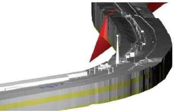
Recently the BGS undertook a 3D modelling project along 28 km of railway line between Leeds and York on behalf of Tata Steel Projects (Burke et al 2015). The model was
constructed using 1:10,000 scale digital geological map data and 102 borehole logs. The final conceptual ground model (CGM) indicated the top and base elevations of the geological units and weathered rockhead and major faults were defined as separate surfaces. The purpose of the work was to identify areas where targeted ground investigation could be undertaken in the early assessments of the design of deep or shallow mast foundations for the electrification of the route. After overcoming substantial challenges with projection systems, the model was delivered as CAD files and the client was able to integrate the CGM within their in house BIM workflow as shown in Figure 1.
Figure 1. BGS Conceptual Ground Model (sandstones and mudstones in grey and yellow plus a fault in red) of a site near Leeds (UK) with existing and proposed overhead line electrification and building infrastructure
3. Underground space assessment and planning tool (from Bricker and Webb, 2015 - http://nora.nerc.ac.uk/513685/1/OR16014.pdf)
What is it?
o A 3D assessment of the urban underground space which includes i) the natural
ground conditions to inform potential hazards and potential resources (e.g. ground heat and water), and ii) underground infrastructure e.g. basements, tunnels, pilings.
o A spatial assessment of ground with favourable conditions for different
activities can be identified.
o Land that is likely to be more cost-effective for development is highlighted. o What if scenarios (e.g. planned pipelines) can be run to highlight hazards and
opportunities in a low-risk pre-development stage. Why is it needed?
o To de-risk investment and unlock potential resources.
o Physical ground constraints: Late stage awareness of ground properties and
o Alignment of Crossrail was influenced by the need to avoid over 200 existing
obstructions and Crossrail2 is to be re-routed via Balham because of geological concerns.
o In 2013/14, three water companies in the UK spent an additional £80 million
in responding to the impacts of groundwater infiltration into the water pipe network.
o 76% of London’s total heat demand could be met by secondary sources (heat
air; water treatment works and ground heat).
o Increased use of open-loop ground source heat systems is causing localised warming of groundwater.
o Applications for 450 basements in Kensington & Chelsea in 2013.
Who will use it?
o Developers, city planners and government agencies to look at the subsurface
constraints and geological opportunity to inform site-specific planning and development and strategic city plans (e.g. energy and water resource supply and infrastructure).
How could it be developed?
o Collaboration between city authorities, British Geological Survey and owners
of underground assets.
Architectures, standards and technologies
BGS receives, makes available, and exchanges data in a number of interchange formats that have relevance to the mapping and modelling of the subsurface. These are:
WITSML for the exchange of well bore and drilling data especially related to the hydrocarbon extractive industries.
AGS Data Format (commas and quotes) standard, for the exchange of geotechnical data from site investigations. It is also hoped that in the near future such exchange will also be possible with DIGGSML, which BGS has helped develop. BGS is also working with AGS to
introduce the description of interpreted geological cross-sections into the next AGS standard.
EarthResourceML for the exchange of digital information for mineral occurrences, mines and mining activity, and mining waste.
GeoSciML which can be used for geological map data, boreholes, and structural features such as faults and folds. GeoSciML is the model/exchange format used by INSPIRE for its
Data Specification on Geology. BGS is actively involved in the development of GeoSciML.
GeoSciML is based on GML and was designed primarily to describe those geological
features shown on geological maps, which have 2D vector based geometry. In terms of OGC web services they have therefore been traditionally delivered using WMS and WFS.
The purpose of describing 3D models using GeoSciML is to enable the models to be queried against both GeoSciML and coverage properties, for example in order to identify those geological units comprising a particular lithology such as ‘sand’ within a specified depth of the surface. Queries of this type enable spatial models to become vehicles for delivering information to the user community, rather than simply visualisations.
xWCPS queries (WCPS and XQuery) have been developed that utilise both the coverage values and the GeoSciML description, and an xWCPS query builder has been developed to act as a user friendly interface to these queries.
For example:
xWCPS query builder for querying Geological Surfaces from the Glasgow Area. Querying for geological units comprising 25% plus sand_size_sediment, less than 30m from the surface in a particular location.
In addition to model surfaces attributed with GeoSciML, gridded data and voxel models were also stored in an array database (Rasdaman open-source community edition), and various web interfaces created to showcase the querying, retrieval, and visualization of the data.
For example:
WCPS query for thickness in a specified range for superficial deposits in a certain location, turning the thickness values into an image.
This dataset is for users who are seeking information about the depth to bedrock/thickness of Quaternary deposits across Great Britain. The transition between Quaternary and Bedrock units is known as 'geological rockhead' and is an important surface for geologists, civil engineers, hydrogeologists and environmental scientists because it is where most physical and chemical properties of the deposits dramatically change. Strength, lithology,
conductivity, porosity, permeability are most strongly affected by this transition surface, so an understanding of how deep it lies beneath ordnance datum is vital.
WCPS query for lithology values of the GeoTOP voxel model of lithostratigraphy and lithology of the Netherlands, to create a X3DOM / WebGL visualization.
The query retrieves multiple slices along the X,Y,Z axes through the voxel model, to give you a feel for the solid nature of the data. Slices along horizontal axes occur every 1000m, whilst slicing in the vertical axis is every 5m. In the browser you can clip along each axis to show/hide the slices allowing the creation of cross-sections, or plan views if desired.
GeoTOP is a detailed three-dimensional model of the upper 30 to 50 meters of the subsurface produced by the Netherlands Organisation for Applied Scientific Research (TNO). It provides the user with a cell-based description of the spatial variability of geological, physical, and chemical parameters in the subsurface. The GeoTOP and other TNO models are discussed in Van der Meulen M. J. et. al. (2013).
Other initiatives
The benefits of a collaboration between OGC and CGI-IUGS have already been successfully demonstrated with the development of GeoSciML, and the benefits of ongoing collaboration through the DWG are:
Benefits to CGI-IUGS of working with OGC:
• a regular and more frequent OGC meeting schedule;
• visibility and a level of accountability to a broader group of stakeholders and communities (ex : 3DIM, Land and Infrastructure, Smart City, Hydro, SensorWeb,…) • access to interoperability expertise and a set of web-based tools and practices supporting consensus-based standards development among widely dispersed and disparate organizations;
• exposure to an ecosystem of tool-builders, from researchers and small companies through to some of the largest geospatial and generic software houses.
Benefits to OGC of hosting a joint working group co-convened with CGI-IUGS include: • rigorous testing of OGC technologies for a domain that uses a wide variety of
"observations" (in-situ monitoring, imagery, gridded simulations) that are in scope for Sensor Web Enablement (SWE), 3D and Coverage related activities
• development of a profiling methodology for OGC standards;
• maturation of domain harmonization/dependencies methodology for spatial data infrastructures (SDI) of regional, national and international scope.
The stated primary goals for the DWG are to:
• Foster technical solutions which support interoperable concepts, data definitions, formats and services for publishing, search, and exchange of water information.
• Ensure thematic/semantic coherence within the Geoscience domains and the
Geoscience related ones: Geology, Hydrogeology, MineralResource, Surface Hydrology, Soil …
• Define proper interfaces with City and Infrastructure related domain
• Support proper exchange with Risk monitoring, prevention and management activities • Focus industry and research organizations attention on the value added of
interoperable approaches
• Identify and work with a select set of partners in this arena, and initiate demonstration projects to develop and publicize best practices in this area.
• Establish a workable approach to managing standards for geoscience spatial features, their temporal aspects, related metadata, and other business information.
Issue: As there appears to be some considerable overlap between the scope of this Concept Development Study, and the goals of the GeoScience DWG, should there be some formalized link between them?
Implementation examples
London: The National Geological Model (NGM) is an accurate, multi-scaled, geospatial model of the subsurface arrangement of the rocks and sediments of the UK. The NGM currently includes the Great Britain bedrock fence diagram (UK3D) and a number of other 3D geological models. One of these models is in the London and the Thames Valley area and covers 4800 km2, extending westwards as far as Newbury and eastwards to the inner Thames Estuary. It was developed by BGS from 2007 onwards and was released in 2014. The London and the Thames Valley model delineates the geological boundaries between 80 artificial, superficial and bedrock units in the Thames Valley and extends from the surface to a maximum depth of several hundred metres.
BGS has also developed a linked series of process models, an OpenMI composition which can be used to test ideas on sub-surface management in the Thames basin and London.
Glasgow: Glasgow, Scotland's largest city, is built along the upper Clyde estuary and lower River Clyde. In the heart of the city are the Clyde Gateway and Clyde Waterfront areas — the national urban regeneration priority for Scotland over the next 25 years. This regeneration is intended to stimulate economic growth, drive smaller community regeneration projects, and tackle concentrated deprivation resulting from industrial decline. To underpin this
regeneration we are developing integrated and attributed dynamic shallow-earth 3D models in partnership with Glasgow City Council and other organisations.
BGS has built a series of groundwater flow and solute transport models covering the Glasgow area. These have been developed to develop workflows and could be fed into the study.
These two cities are offered as case studies on which to test approaches.