Informatie Vlaanderen
Boudewijnlaan 30 1000 Brussel
T +32 (0)2 553 72 02
Koningin Maria Hendrikaplein 70 9000 Gent
T +32 (0)9 276 15 00
///
KLIP as a response to the OGC
underground RFI
////////////////////////////////////////////////////////////////////////////////////////////////////////
From: Jef Daems – Informatie Vlaanderen ([email protected]) To: OGC technology desk – ([email protected])
Date: 14/3/2017
1 DESCRIPTION OF RESPONDING
ORGANIZATION: INFORMATIE
VLAANDEREN
Informatie Vlaanderen is to build a government-wide information policy and supports Flanders in its transition to an information-driven government.
The new agency was created by merging the Flanders Agency for Geographical Information (AGIV) and the Flanders Department for Information. Both were government authorities.
The agency is to support the regional government with its digitization policies, acquisition, management and use of information, along with the integration of eGovernment services and management of public archives. Government information (data), and eGovernment services should be made available in user-friendly ways, and the agency is to involve public administrations, companies, organizations and citizens to make use of this information.
Informatie Vlaanderen can be translated as the information agency of Flanders and is to build and manage a central data platform to organize all public administration products and services, and is helping to integrate these products and services into the processes and solutions of other organizations.
Products and services
The agency offers several products and services. Examples include the Geoportal, which aggregates the region’s geographic information, the GRB, the region’s topographic reference database, and VKBO, one of the country’s crossroads databanks, aggregating all information related to enterprises.
Why does Informatie Vlaanderen respond to the RFI?
Our agency is responding to this RFI because we have built and are operating an e-government solution, KLIP, that is facilitating the sharing of underground information in the Flanders region.
This solution is based on the following key components:
1. A common information model for cables and pipes (IMKL), based on the European INSPIRE standard for utility services,
This fully digital phase of KLIP is operational since the 1st of April 2015 and with great customer satisfaction. We can boldly say that our agency has reached a significant hands-on expertise level, including the necessary “good practices” and “lessons learned”. This couldn’t be achieved without a strong commitment of and a thorough collaboration with our principal stakeholders:
1. The utility network authorities in the role of data providers,
2. The construction sector and engineering agencies in the role of consumers,
3. Geographical IT service and software providers
Therefore, we believe it is useful to share our practical expertise with the outside world. The KLIP solution, based on a Flemish regional context, can be a reference solution for a more universal, OGC supported approach for sharing underground information.
2 KLIP, AN EXECUTIVE SUMMARY
KLIP is in fact quite a radical solution in Flanders of exchanging digital utility network information based on INSPIRE specifications.
cables and pipes”). This vector model is based on the INSPIRE data specifications on Utility Services.
3 USE CASES FOR UNDERGROUND
MAPPING AND MODELING
The region of Flanders contains at least 600,000 kilometers of underground cables and pipes along its roads. each meter of road in Flanders has an average of 8 meters of utility assets. In the near future, this amount is more likely to increase than to decrease. It is important that contractors do not damage these cables and pipes when carrying out excavations. The gas pipe disaster in the Belgian municipality of Ghislenghien in 2004 is a tragic example of the possible damages that can be caused. Mostly, incidents do not reach such a scale, but every damage incident involves a number of risks:
1. the risk of physical injury for the excavators, local employees or residents,
2. the immediate material damage to cables, pipes and to the contractor’s equipment,
3. the consequential damage, which may be limited to a temporary inconvenience, but which may also have a major economic, health and safety and/or environmental impact.
In addition, more incidents occur than one might suspect.
A major cause of damage is the lack of accurate and complete information about the presence of cables and pipes in the ground.
For planning and executing excavation works, map request initiators (contractors, engineering consultancy agencies etc.) need information about the location and the specifications of underground cables and pipes. These assets are managed by the various utility network authorities (utility companies, public administrations etc.). The Kabel- en leidinginformatieportaal KLIP (Cable and Pipe Information Portal) facilitates the exchange of this information between these parties involved in order to prevent damage to cables and pipes when carrying out excavation work..
Map request initiators can send their request for information to all utility network authorities (UNA’s) involved in the area of the planned works through one single KLIP request. The various network operators involved will upload their digital answers into KLIP. Finally, KLIP is consolidating the various answers into a single viewing package, based on a uniform data model, with a uniform legend and visualized using a uniform background map.
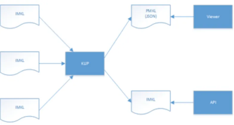
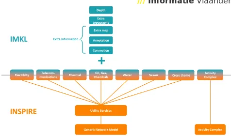
that, when a map request is made, the utility network authorities are able to transmit information to the KLIP relating to different types of cables, pipes and utility types (gas, electrical power, drinking water, sewage, telecommunications etc.) in a standardized manner. This joint conceptual framework is the IMKL (Informatie Model Kabels en Leidingen) (Information Model Cables and Pipes). Its visual representation is laid down in the PMKL (Presentatiemodel Kabels en Leidingen) (Presentation model Cables and Pipes).
The rules governing the use and the operation of the KLIP are set out in the KLIP Decree. Since the 1st of September 2009, all utility network authorities operating in Flanders are obliged to register their geographical activity area in KLIP. Next to this, any organization planning to carry out excavation works in Flanders, is to submit a map request via the KLIP. Before the current KLIP solution was in place, the map request initiators were receiving the maps of the various utility network authorities in different formats, using various scales, legends and background maps. They had to integrate and summarize all this information into a kind of useable way. On the 1st of January 2016, a major step forward was taken, because since then all utility network authorities are obliged to supply the information in a digital IMKL format KLIP.
Since the obligation of 2009, the number of incidents of damage to underground utility assets due to excavation works has dropped. Even though the exact contribution is difficult to establish, the stakeholders (construction industry, utilities sector as well as the insurance sector) are explaining the decrease to the operation of the KLIP as the central map request module, combined with an increased focus of attention given to health and safety and prevention during the preparation and execution of excavation work. In order to retain and decrease of the number of damage incidents, the KLIP’s operation was expanded in 2016 to include the digital transmission of the information and the provision of the information in a single integrated map carrying a standard legend.
Fewer damage incidents to underground cables and pipes also yields significant gains for society as a whole, not only because fewer costs are incurred to repair the direct and indirect damage, but especially because unnecessary costs are avoided, whilst ensuring greater safety for people and the natural environment.
4 ARCHITECTURES, STANDARDS AND
TECHNOLOGIES
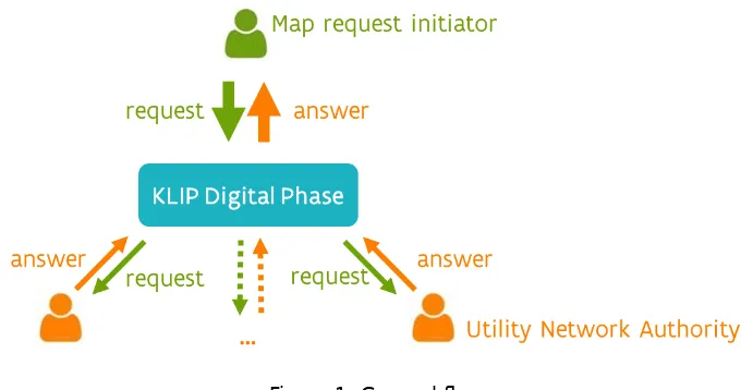
4.1KLIP APPLICATION - GENERAL FLOW
The general flow is explained below in figure 1. The utility network authorities (UNA) upload their operating area (UNA area) via the portal. The KLIP uses these areas to determine whether any given network operator is involved in a map request. When a user wishes to request underground information for a particular area, he specifies the area where he is planning to carry out excavation works. He also provides more details about the works: how deep he will be digging, which kind of machinery he will be using, why he is undertaking the excavation work, etc. KLIP check to see which utility network operators are active in the map request area and passes the request on to them.
The network operators prepare their answer to the map request and upload it as an IMKL package.
As soon as the due date for responses expire or as all involved network operators uploaded their replies, KLIP compiles the response package for the map requestor by collating all replies and by selecting the appropriate background map.
The map request initiator can access the information by viewing the answer in the KLIP web portal, by downloading the IMKL data packages or by downloading a viewable package for use in the KLIP offline viewer.
Further documentation about the KLIP application is available at:
https://www.agiv.be/producten/klip/klip-help (in Dutch)
Figure 2: Detailled flow
Figure 2 is explaining the more detailed flow of a map request. A premise for this flow is that the utility network authorities (UNA’s) have uploaded their operating areas (UNA areas) via the portal. The following steps are carried out during the map request process:
1. The Map Request Initiator creates a map request by specifying the nature and area of the excavation works by using the KLIP portal or by integrating the KLIP web service API in his own software.
2. The Map request initiator pays and submits the map request. Alternatively, the submissions of larger organizations or organizations using the web service API will be invoiced every three months.
4. The UNA receives the request and starts to process it by checking his own digital network asset information. He will either prepare the answer by processing IMKL data and send it to KLIP or inform KLIP that he is not involved.
5. KLIP carries out a technical validation of the IMKL data.
6. As soon as the response time expires, or all network operators answered, KLIP will create the complete response package.
7. The map request initiator can access the information by using online or offline viewer or downloading the IMKL package.
8. When the KLIP response package is complete, containing all UNA answers, the Map Request Initiator can start with the excavation works.
4.2STANDARDS
4.2.1 Exchange model: IMKL
The European exchange standard for cable and pipe information (INSPIRE Utility Services, abbreviated as ‘INSPIRE US’ below) was adopted as basis for the IMKL. This standard was extended to include several IMKL-specific elements that are important to the specific context of KLIP. For those utility network authorities that are to comply with INSPIRE regulations, this model extension has operational benefits, because no extra transformation service is needed in order to comply with regulations set out by the KLIP Decree as well as those set out by the INSPIRE directive. By filtering out the IMKL-specific elements, it is possible to exchange subsets of cable and pipe information through the same information service in an entirely INSPIRE-compliant way.
In addition, the model extension technique has been reused. In Flanders, the IMKL model was adopted and extended itself as the basis for the AWIS project of VMM (Vlaamse Milieumaatschappij) (Flemish Environment Agency). The aim of this project is to build an integrated waste water information system. The data relating to waste water are scattered across various organizations. As such, the first step was therefore to develop a model for the exchange of data between the sewer network authorities and VMM. By analogy with the expansion of IMKL to INSPIRE, expansions to IMKL were developed specifically for this business case. The benefits are obvious; the sewer network authorities can use the same basic set to comply with the INSPIRE, KLIP and AWIS obligations.
possible mutual relationships between objects are modeled. Objects with identical properties are clustered into object classes.
IMKL2.2
INSPIRE
US 3.0
INSPIRE
GCM
(Network)
Figure 3: Schematic representation IMKL model
For KLIP, the files supplied by the UNA’s are technically validated against the IMKL object model diagram. In addition, an extra rules document is used, containing further specific rules, with validations conducted against cross-references, unique IDs etc.
4.2.2 Presentation model: PMKL
Figure 4: Schematic representation IMKL - PMKL
The PMKL renders the geography and the attributes of IMKL data objects, if applicable; not all IMKL data objects have a geographical attribute, but make up a collection of data objects, for instance (e.g. UtilityNetwork). Some attributes help to define the form of the presentation, for example the code lists of the pipe elements (appurtenances) and the status of a given cable or pipe.
The IMKL is the jump-off point to arrive at maps - based on PMKL presentation rules – that deliver an integrated picture of the various IMKL data objects supplied by the UNAs. As such, the PMKL adds styling to the IMKL data objects. The main aspects of PMKL styling are color coding, line styling and point symbolism.
4.3KLIP APPLICATION
4.3.1 Architecture
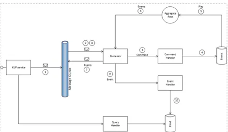
CQRS with Event Sourcing
Figure 5: CQRS with event sourcing
The architecture is based on CQRS with event sourcing. The main aspect of this model is that the commands (writes) are separated from the queries (reads). Instead of storing the state in a conventional model in a standard database, it is the list of events that are saved here. Based on the events, the state of a given object is reconstructed. E.g. map request created, overlay ready, UNA has confirmed, UNA has replied etc. This model is suited for KLIP as it is a natural audit log that keeps track of which actions are put in place in response to a map request over time.
Projections can be linked to each event. A projection projects the information from the event to a non-standardized model that was optimized to allow efficient access the information.
Figure 6: Architecture
1 A command (e.g. run map request) comes in via the API service. The API assigns the command to a message queue. This message queue spreads the load.
2 One or several processors listen to the queue and process the commands in the queue. In the case of high or low load, the processing capacity is scaled accordingly.
3 The processor transmits the command to the correct command handler.
4 This command handler invokes domain logic that will create the map request in the domain and will register the event created by the map. This event is persisted in a storage container.
5 When a UNA replies to a map request, the domain logic will first reconstruct the state of the map request aggregate root based on its event log. The domain logic will then adjust the status of the map request, by registering that the UNA has replied to the map request.
6 The events thrown by the aggregate root are placed in the message queue by the processor and asynchronously processed by event handlers.
7 The event is placed in the queue by the processor. 8 The processor retrieves the event from the queue.
9 The processor sends the event to the correct event handler.
onto a table that has been optimized for fetching the details of a map request.
11 A query (e.g. provide information about a map request) comes in at the API service. A query handler retrieves the information about the map request.
4.3.2 Domain model
For the development of the KLIP, the Domain Driven Design (DDD) method was applied, Using Ubiquitous language.
The domain model was designed in close co-operation with Business and IT.
4.3.3 Technology stack
In KLIP, the following technology is used: 1 Website
The KLIP Web API is a REST API over HTTPS, secured by the OAuth 2.0 protocol. The API supports communication with JSON and XML. If you want a response in XML, you set the HTTP Accept header to request/xml, if you want a JSON response you set the header to request/json. If you are running an HTTP POST request in XML, you set the HTTP Content Type header to request/xml, if you want to run the POST request in JSON, you set the header to request/json.
All POST instructions are asynchronous. There is a synchronous request validation that returns the status 200 OK. This code provides the assurance that the request has been duly received and will consequently be processed. The processing as such is asynchronously.
The KLIP Web API is functionally broken down into methods for the Map Request Initiator https://klip.agiv.be/api/mri and the Utility Network Authority https://klip.agiv.be/api/una.
The documentation is in English.
4.3.5 Security signing for IMKL diagram
To mitigate the risk associated with the loss of integrity of maps, optionally the IMKL files can be digitally signed using a mature and widely used state-of-the-art technology. Th digital signature guarantess both the integrity and the authenticity of the IMKL files.IMKL files are in fact zip files. Therefore, the zip file is signed for its entire content.
As such, the presence and verification of a digital signature on the IMKL file guarantees the non-repudiation of the UNA with respect to the maps that were correctly supplied by the UNA.
However, the presence of a digital signature does not in itself constitute proof to the UNA that the KLIP actually received the maps transmitted. To make the chain fail-proof, a confirmation of receipt, digitally signed by KLIP, is required for the maps sent to the UNA. Therefore, KLIP will digitally sign the validation report of a digitally signed IMKL file.
Digital signing is only for optional use by the UNA. The digital signing of the IMKL pack takes place in accordance with the RSA algorithm and the SHA-256-hash function.
For further details on the digital signing the IMKL file, see:
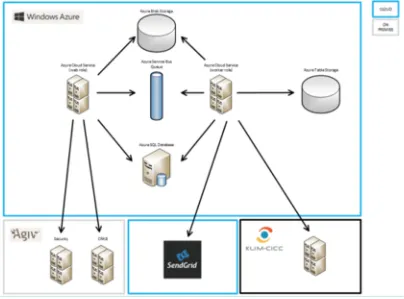
4.3.6 Infrastructure
The KLIP solution consists of 4 main infrastructural elements.
At first KLIP’s main deployment is located in the cloud, on the Azure platform. In this way, the architecture can be scaled, optimizing the infrastructure according to the real-time needs. For example, when handling more resource-sapping tasks (such as the printing task), more processors can be brought in on a dynamic basis.
Next to this, a number of on-site services and applications are used. These services that are also being used by other applications and departments are maintained by the Informatie Vlaanderen, .
In addition, KLIP also uses third-party tooling for transmitting mails.
Finally, in order to support the execution of a number of federal (Belgian) obligations with regards to underground information exchange, KLIP is exchanging map request information with KLIM/CICC, a software solution opposed by the federal government.
5 IMPLEMENTATION EXAMPLES
5.1WHO IS USING KLIP?
The target groups of KLIP are quite diverse, covering all parties that are involved in excavation works.
The KLIP users can be categorized into the following main profiles:
map request initiator: In general, everyone who uses machinery to carry out excavations in Flanders is obliged to submit a map request via KLIP. In practice, by far most map requests are done by professionals. Thee professionals can be public administrations or utility companies, contractors of (public) construction works and engineering consultancy agencies. On the other hand, citizens can also retrieve cable and pipe information via KLIP for personal use on their own property;
utility network authority (UNA): All network operators active on Flemish territory are required to register: . the distribution, transport and local networks. Furthermore, the operators of high voltage power lines and installations for the transport of gaseous and other products by way of pipes are registered with the KLIP. These UNAs can beconventional utility companies, local, regional and federal government authorities or other organizations managing or operating an underground network, such as universities, hospitals etc.;
public domain administrator (PDA): local and regional
administrations, port authorities, NMBS (the national railway operator) etc. that oversee part of the public domain.
Some organizations or businesses obtain more than one profile. For instance, a local council can act as the network operator for the public domain, as the map request initiator but also as the utility network authority (for instance for local sewers). Most utility companies also act as both utility network authorities and map request initiators.
5.2PORTAL
Map request initiators, utility network authorities and public domain administrators use the KLIP web portal.
UNAs are using the portal to manage their UNA areas and to answer the map requests.
Public domain administrators use the portal to get an overview of the map requests in their specific public domain area.
Figure 8: Detail of a map request
5.3API
The portal is in fact a basic implementation of the web service API, enriched with some interactive usage and viewing capacities. Users can also implement the KLIP web service API in a direct way, both for requesting maps and for replying to these queries. Users can also download the IMKL answering packages via the API.
With few exceptions, all major utility network authorities make the KLIP responses in an automated way: they automatically retrieve the map requests addressed to them, compile the answer and transmit it to KLIP via this secured web service API. The network operators contracted experienced service providers to execute their automation project.
5.4IMKL
All UNAs are to transmit their map request answers in compliance with the IMKL model. As stated before, this model is an extension of the INSPIRE data model for Utility and Governmental services. It was designed in close collaboration with both the map request initiators and the utility companies and is limited to information which helps to prevent excavation damage.
Each answer from a utility network authority consists of an xml-file containing at least the cable and pipe data. In addition the network authority can add a number of extra files (pdf, jpg, png and tiff) containing reply letters, safety guidelines, extra detailed maps, length profiles etc All these files are zipped into 1 package. Optionally this package may be digitally signed to ensure its integrity and authenticity.
Figure 9: High level summary IMKL model
5.4.1 Vector downloads
The IMKL responses can also be downloaded as the raw XML-data, as transmitted by the UNA, i.e. without any kind of modification or layout.
5.5VIEWER
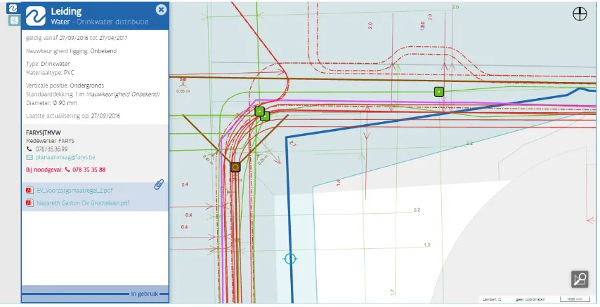
Figure 10: Example of a map view in the viewer
Figure 11: More details of the water mains
5.6PRINT
The pdf-file with the map view is layered: the utility network information can be switched on or off per utility type or per utility network authority. The print files can only contain the visual map data, i.e. not the more detailed attribute data which the user access in the viewer.
5.7OFFLINE VIEWER
The offline viewer has all features as the online version, except the printing function. This viewer is intended for consulting the KLIP data via a tablet or a laptop at the building site Currently only a Windows version for offline viewing is available. We are planning native offline viewer versions for Android and iOS.
5.8GRB , A LARGE-SCALE REFERENCE LAYER
When presenting the utility networks of the UNAs, they are rendered on a standard background: the Grootschalig Referentiebestand (GRB) (large-scale reference database). This is a, large-(large-scale topographical reference covering the complete region of Flanders. The GRB contains the geographical and representative information from easily definable, conventionally accepted reference data: buildings, plots, roads and their layouts, water courses, railways and the highway network. These objects are detailed and carefully measured so that the data is usable in a large-scale presentation with a large-scale range between 1/250 and 1/5000.
5.9PROJECT APPROACH
5.9.1 Project flow
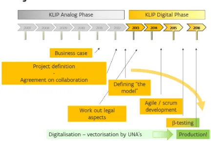
Figure 12: KLIP project flow
The project started with the workout of a business case, in collaboration with the stakeholders involved. The core result was a cost/benefit analysis for these stakeholders and the Flemish government. Next to this analysis, the stakeholders and the government authorities got convinced of the digital phase idea for KLIP, prepared a project definition report and made a formal collaboration agreement for the project in order to formalize the commitments of all parties involved.
The first phase of the real project was to define the IMKL and PMKL models that were necessary to start the digitization and vectorization efforts at the utility network authorities. Also the legal aspects for the digital exchange of underground data were tackled.
5.9.2 Project governance and stakeholder interaction
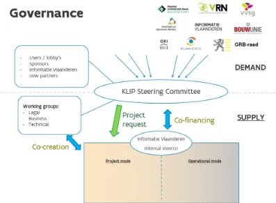
As stated above, a formal collaboration agreement was signed by the stakeholders involved. In this agreement the project governance was laid out according to the figure below. The basic governance philosophy is to establish a demand-driven approach for the project.
Figure 13: KLIP project governance
All main stakeholder groups are represented in the KLIP Steering Committee. thee groups are the construction sector, utility sector,
engineering study agencies, federal, Flemish and local authorities. Based on the decisions in the Steering Committee, project requests or major change requests are asked to Informatie Vlaanderen, our Flemish
government agency that is responsible for the project execution and the operational management of the system. During project development, different working groups (legal, business and technical WG) are
During the development and before taking the system into production, user tests are held even in an onsite configuration (i.e. at the building sites).
The conversion of utility network data was not part of the development project. This was the complete responsibility of the UNAs. These
conversion projects were carried out by the companies themselves or with assistance of specialized service providers.
When the results were deployed, the internal training, communication and support teams of Informatie Vlaanderen are taking over the interactions with the users. Project and operational follow-up are reported to the internal steering of the project as well as to the KLIP Steering Committee.
5.9.3 KLIP feedback loops
Based on the governance model above, we can identify 4 feedback loops within the KLIP project and operational context.
Figure 14: KLIP feedback loops
1. Scrum team interaction in project mode, facilitating the interaction between product owner, alaysts, developers and testers on a daily basis
3. Feedback loop with the external users and stakeholder groups involved, during the project, in order to improve the final solution during the workout.
4. Demand-and-supply feedback within the Steering Committee. At the highest level, in order to safeguard the right direction of the project.
5.9.3.1 Kabel- en leidingbeheerders
Alle leidingbeheerders die actief zijn op het Vlaamse grondgebied, moeten zich registreren in KLIP. Hierdoor bevat KLIP zowel leidingbeheerders met distributie-, transport- als lokale netten. Ook de beheerders van
hoogspanningsleidingen en installaties voor het vervoer van gasachtige en andere producten door middel van leidingen zijn geregistreerd in KLIP.
5.10
PROJECT RESULTS
5.10.1
Standardization of management processes and
digitalization of data on underground infrastructure
The use of KLIP by plan requestors and network utility operators is mandatory by law since 2009. Since the first version of the KLIP Digital Phase portal was put into production, a new and completely digital era has arrived. As of January 1, 2016, the digital exchange – using the IMKL model - is mandatory.
There are 219 registered UNAs. Every year KLIP collects about 200.000 requests and sends them to –an average of 6 to 7 UNAs. As a result the KLIP platform receives between 1.200.000 and 1.400.000 IMKL data response packages each year. Only a few very small network operators are not yet fully digitalized.
So, as a result of the project and thanks to the very close collaboration between the stakeholders and the Flemish government, the utility network authorities in Flanders have managed to digitize the content of the network within 5 years, in a standardized way, thus facilitating the exchange of information.
5.10.2
Reduction of damages
5.10.3
Reduction of administrative burden
Before this digital phase of KLIP, network operators were still sending their information in a non-standard format: on paper, CD-rom, stick, emailing pdf-scans or other, on different scales, with different geographical reference systems and different background maps. It still took a long time for map requestors to interpret and to combine all these information sources in a usable way. The electronic exchange with its standardization has brought an overall reduction of 60% of the administrative costs, despite the fee that has to be paid for the KLIP map request.
5.10.4
Reduction of response time
KLIP regulations were adapted so that the standard time for an UNA to respond to a map request has been decreased from 15 to 7 working days. Furthermore, thanks to the automated processes implemented by most UNAs, almost all answers are available within one to two days after the map request submission in KLIP. Only if dangerous underground infrastructure is involved, response time can take longer because some study work is needed before an answer van be given.
5.10.5
Starting point to enhance the data quality
The primary goal of KLIP was not to enhance the data quality, but it was foreseen as a possible positive side effect. In a first phase data were digitized “as is” from old maps, drawings. In some cases, old data from early asset database are mapped to the IMKL format. Some network operators took the opportunity to localize the network exactly but this was not mandatory. After this first digitalization effort, some UNAs started a second phase aiming a significant increase of the data quality.
5.11
LEGISLATION
Since the 1st of September 2009, all Utility network authorities have been under the obligation to register in KLIP, and to report the area they are operating In addition (equally since September 1th 2009), everybody who is planning to carry out excavation work has to submit a KLIP map request.
new KLIP, the maximum standard response time stated by law could be decreased from 15 working days to 7 working days.
5.12
ENFORCEMENT
Based on the KLIP decree, the Flemish government is not empowered to impose administrative fines if map request initiators or utility network authorities fail to comply with their obligations. However, one has the ability to start a case in court in order to get a conviction based on criminal law and to receive compensation for the damage done..
6 RESUME: MAPPING OF THE KLIP
PROJECT WORKOUT WITH THE
RESPONSE ELEMENTS OF THE RFI
(§2.5)
6.1EXISTING DATA MODELS AND SOFTWARE
The underground infrastructure is modelled according to the Informatiemodel Kabels en Leidingen (IMKL) (Cables and Pipelines Information Model). This standard is an expansion of the INSPIRE standard for Utility and Governmental Services. However, the IMKL model does not use the CityGML model. Undergound infrastructure data are transmitted in xml format. The geometries are described in accordance with gml 3.2. The data are visualised in a self-compiled OpenLayers3 viewer and rendered on a common background: the Grootschalig Referentiebestand (GRB) (see above).
6.2CURRENT STATE OF CITY
INFRASTRUCTURE MAPPING AND DATA
MANAGEMENT
The IMKL model is used across all of Flanders to exchange utility network data. Both in densely populated areas (such as the cities of Antwerp and Ghent), and the less densely populated countryside. the utility network authorities (UNAs)are responsible for the conversion of their proper underground information into the IMKL model. The nature of these UNAs is highly diverse: they are ranging from very small, responsible for a few hundred metres of cable to network operators operating at a nationwide level, having cables in almost every single street in Flanders.
6.3TECHNOLOGY TRENDS THAT ANTICIPATE
FUTURE INTEROPERABILITY
REQUIREMENTS
As a first step towards a solution it is important to have good quality data that are available.
For safety reasons and considerations of competition, utility networks in Flanders will not be made accessible as open data nor linked open data any time soon, .
The links between the data and the networks can be visualized in KLIP but there are no real links. This would only be possible if the UNA make the data available as linked (open) data, or if the data were stored and maintained in a central data base..
At the moment, the entire KLIP platform (on which the underground infrastructure data are exchanged) is hosted in the cloud on Azure platform. Both for the submission of map requests and the exchange of the data, users have a choice between using the KLIP web portal or to integrate the web service APIs into their own software.
6.4CONTINUITY/CONNECTEDNESS OF BELOW
AND ABOVE GROUND ASSETS AND
STRUCTURES.
6.5INFRASTRUCTURE RELATIONSHIPS TO THE
NATURAL ENVIRONMENT
The IMKL is not modelled to establish links between or to create references to other reference files. As such, it is impossible to create, for example, a link between a sewage pipe and the river into which it runs.
However, the IMKL model can be expanded, in the same way as the IMKL model is an expansion of the INSPIRE model. These expansions can also contain links to other (reference) files. information necessary to prevent excavation damage – the use case of KLIP.
Due to the KLIP project and the IMKL model, it was a good starting point for Utility Network Authorities to start the digitaing operation. After having digitized for KLIP, they only needed to add extra information to be able to use their digitized network for its operational management. The extra data for operational use is not exchanged with the map request initiators.
6.7 RELATIONSHIPS BETWEEN NETWORKS
Relationships between utility networks may be transmitted via IMKL. To be able to do so, all referenced objects should to be available for consultation and retrieval.
6.8 WORKFLOWS
In its own environment, the Utility Network authority is free to use any data model to manage its network. However, in exchange with KLIP, the data should be mapped or converted to the IMKL structure before sending the answer to KLIP.
6.8.1 New networks
The UNA can exchange information about planned underground infrastructure as well as actual infrastructure. The status attribute will have the “planned” status. As ‘as built’ maps are made available, the information is corrected and completed, The UNA includes its infrastructure in the desired data structure right away. This data structure does not necessarily need to be in compliance with the IMKL, but it must be possible to convert the data into the IMKL structure.
6.8.2 Existing, as yet non-digitized networks
6.8.3 Networks that transfer to a different network operator
When UNAs go into merger, or one operator takes over a network of another, the network data can be exchanged in accordance with the IMKL model since the mapping efforts between the various databases to IMKL has already been done..
Of course the extra information concerning the operational issues are not covered by the IMKL standard, so this will need to be converted as well.
6.8.4 Statutory/legal requirements
Since the decree of 2014 every UNA has to answer in IMKL format. So all the data of the underground infrastructure needs to be digitized. Before this decree, not all communities or UNAs knew the exact position of the cables and pipes. The KLIP application and the decree has had a positive impact on the knowledge of the underground infrastructure. The digitalization has a positive impact on the exchange of data. As a next step, we can already see that the KLIP platform and IMKL data is being used for other use cases. Furthermore there are other legal requirements on a federal (Belgian) level: there is a federal law with regards to the transportation of gas, electricity and dangerous products. KLIP is connecting with the federal solution that is supporting this law.
7 “AS IS / TO BE”: FUTURE COLLABORATIVE
OPPORTUNITIES
Having said all of the above, this document is just a starting point. Informatie Vlaanderen can think of the following opportunities for further collaboration with the OGC
community:
Further knowledge sharing and documentation with regards to the models
(IMKL/PMKL), the current viewing facilities, the project approach, governance and a variety of good practices and lessons learned
Possibilities for sharing and extending the Flemish model
Collaboration possibilities on a Belgian level (already in preparation), with the Dutch Kadaster, with the Scandinavian governments (already in consideration)
Use or extension of the viewer or viewing technology
The effective collaboration with geographical IT service providers
The collaboration setup with the construction sector and regional utility sector
The background of the user-centric design of the web portal