Underground RFI LandInfraSWG response
20170315 pxsOverview
The Open Geospatial Consortium Land and Infrastructure Standards Working Group was chartered to develop land and infrastructure facility standards. It was decided to take a use case driven approach followed by the development of a UML
conceptual model (LandInfra) and then a GML encoding (InfraGML).
The OGC Land and Infrastructure standard (OGC 15-111r1), LandInfra, is a UML Conceptual Model, specified as an approved OGC Standard (OGC 15-111r1). Independent of implementations, its target is encoding standards, such as GML , SQL, or JSON. InfraGML is one of those LandInfra encodings.
LandInfra
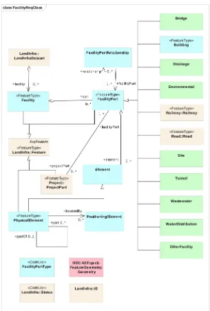
LandInfra is “all about the land upon which infrastructure facilities are built and the infrastructure facility improvements themselves, including the surveying necessary for the construction and recording of the facilities and land interests.” Following the OGC Modular Specification guidelines, LandInfra is divided into 15 Requirements Classes. Each of these modules focuses on a particular subject area within LandInfra (see Figure 1 below). Application software can then choose which
modules to support, taking into consideration the dependencies (arrows) shown in the figure.
The scope of LandInfra is land and civil engineering infrastructure facilities. More specifically:
Anticipated subject areas include facilities, projects, alignment, road, railway, survey, land features, land division, and “wet” infrastructure (storm drainage, wastewater, and water distribution systems). The initial release of this standard is targeted to support all of these except wet infrastructure.
Land provides the environment upon which infrastructure facilities exist. This standard includes division of land based on administrative
(jurisdictions and districts) as well as interests in land (e.g., land parcels, easements, and condominiums). The standard also includes support for topography (terrain) as well as subsurface information. Finally, this standard regards the surveying needed to locate infrastructure facilities on the terrain in compliance with interests in land.
Infrastructure facilities are improvements constructed and operating on land. This standard includes support for information about civil
engineered facilities, such as roads and railway and in the future, “wet” infrastructure including storm drainage, wastewater, and water
distribution systems. Though often not considered to be infrastructure, buildings are included to a limited extent.
The contributors to this standard do not anticipate that the design of utilities, such as electrical distribution, gas networks, and
telecommunications will be explicitly included as facilities, though the detailed location of such facilities may at some point be added for
referenceability. However, the rough location and legal protection of such facilities are covered in this standard by the easement type of land
division.
Furthermore, the standard provides links between land parcels and features located above, on, or below the land parcel surface but which are established and owned by a party other than the owner of that land parcel. Called superficie objects, these features might be buildings or other construction, including pipes, cables or tunnels. Subsurface superficie objects may include a volume of soil surrounding the construction.
The LandInfra conceptual model was developed in close collaboration with the buildingSMART International (bSI) Infrastructure Room. This group is responsible for developing Industry Foundation Classes (IFC) to enable a BIM approach to the
design and construction of infrastructure facilities by extending already ISO
InfraGML
InfraGML then is the OGC GML schema specification for the LandInfra concepts. InfraGML was written in eight Parts, each targeted to become a separate OGC standard (OGC 16-100 through 16-107, anticipated to be approved by 2Q17). InfraGML marks a significant, pragmatic realization in the often-idealized integration of GIS/CAD/BIM. Based upon the LandInfra Conceptual Model developed by OGC with buildingSMART International it builds upon and extends an OGC GML3.2 and 3.3 foundation for features, data types, spatial schema, coordinate and linear referencing, and observation and measurement. It provides a framework for
addressing a full facility life cycle asset management approach for various types of infrastructure facilities.
As can be seen in Figure 2, it is anticipated that LandInfra (and therefore InfraGML) will be extended to include other types of Facility Parts. Work has already begun on Site and the “wet” infrastructure types, including storm drainage, wastewater, and water distribution systems. It is anticipated that these will follow the Roads and Railways Parts, including specification for the elements that comprise each of these types of facility.
Other ongoing OGC efforts
Meanwhile, the OGC CityGML SWG is revising their existing Utilities Application Domain Extension (ADE), potentially reformatting it as a Modular Specification conformant module “extension” to a newly structured CityGML core module. The PipelineML SWG has begun development of an OGC standard for (petroleum) pipelines and is considering making this a LandInfra extension. Joint discussions with these two groups and the LandInfra SWG plus the anticipated Underground Infrastructure effort will hopefully lead to a more harmonized solution to these related subject areas.
LandInfra/InfraGML and the Underground Infrastructure
effort
As can be seen from the above discussion, the underground infrastructure cited in the Request for Information on Underground Infrastructure Mapping and Modeling would fit well within the context of the LandInfra/InfraGML standards. InfraGML has already gathered the essential foundation information covering features, data types, spatial schema, coordinate and linear referencing, and observation and
measurement in the Part 0 Core. The underlying facility (and project) information is already covered in Part 2, as well as the land feature (Part 1), land division (Part 7), survey (Part 6), and alignment (Part 3) context for locating such facilities and addressing legal implications (Part 7). Underground Infrastructure facilities can be added as additional module “extensions”, following a format like what has been done with Roads and Railways (Parts 4 and 5, respectively).
The LandInfra SWG therefore welcomes the opportunity to work with the Underground Infrastructure standards development team. It hereby refers the Concept Development Study group to the LandInfra Conceptual Model standard (OGC 15-111r1), including use cases, and the corresponding Executive Summary (OGC 16-000r1) at http://www.opengeospatial.org/standards/landinfra . We believe that such collaboration can benefit the UI team by giving them a jump start on conceptual modeling and GML encoding. We believe it will also enhance
LandInfra/InfraGML as it brings these additional types of facilities under the same umbrella, enabling users to view facility information together and consistently, regardless of facility type.