Open Geospatial Consortium
Publication Date: 2014-07-23 Approval Date:2014-03-30 Submission Date: 2014-03-05
Reference number of this document: 14-021r2
Reference for this document: http://www.opengis.net/doc/ER/testbed10/cci-profile-interoperability
Category: Public Engineering Report
Editor(s):Gobe Hobona, Roger Brackin
OGC
®Testbed 10 Cross Community Interoperability (CCI)
Profile Interoperability Engineering Report
Copyright © 2014 Open Geospatial Consortium.
To obtain additional rights of use, visit http://www.opengeospatial.org/legal/.
Warning
This document is not an OGC Standard. This document is an OGC Public
Engineering Report created as a deliverable in an OGC Interoperability Initiative and is not an official position of the OGC membership. It is distributed for review and comment. It is subject to change without notice and may not be referred to as an OGC Standard. Further, any OGC Engineering Report should not be referenced as required or mandatory technology in procurements.
Document type: OGC® Engineering Report
Document subtype: NA
Document stage: Approved for public release
Preface
This Engineering Report was prepared as a deliverable for OGC Testbed 10, an initiative of the OGC Interoperability Program. The document presents the work completed with respect to the Cross Community Interoperability (CCI) thread within the testbed. The work has been commissioned in order to inform geospatial information frameworks of the Defence Geospatial Information Working Group (DGIWG), National System for Geospatial Intelligence (NSG) of the US National Geospatial Intelligence Agency (NGA) and the UK Ministry of Defence (MOD).
The Engineering Report presents an analysis and assessment of interoperability between DGIWG, NSG and UK MOD profiles of Web Map Service (WMS) and Web Feature Service (WFS) standards of the OGC. The engineering report also presents findings from the implementation of the reference profiles.
Copyright © 2014 Open Geospatial Consortium. iii License Agreement
Permission is hereby granted by the Open Geospatial Consortium, ("Licensor"), free of charge and subject to the terms set forth below, to any person obtaining a copy of this Intellectual Property and any associated documentation, to deal in the Intellectual Property without restriction (except as set forth below), including without limitation the rights to implement, use, copy, modify, merge, publish, distribute, and/or sublicense copies of the Intellectual Property, and to permit persons to whom the Intellectual Property is furnished to do so, provided that all copyright notices on the intellectual property are retained intact and that each person to whom the Intellectual Property is furnished agrees to the terms of this Agreement.
If you modify the Intellectual Property, all copies of the modified Intellectual Property must include, in addition to the above copyright notice, a notice that the Intellectual Property includes modifications that have not been approved or adopted by LICENSOR. THIS LICENSE IS A COPYRIGHT LICENSE ONLY, AND DOES NOT CONVEY ANY RIGHTS UNDER ANY PATENTS THAT MAY BE IN FORCE ANYWHERE IN THE WORLD.
THE INTELLECTUAL PROPERTY IS PROVIDED "AS IS", WITHOUT WARRANTY OF ANY KIND, EXPRESS OR IMPLIED, INCLUDING BUT NOT LIMITED TO THE WARRANTIES OF MERCHANTABILITY, FITNESS FOR A PARTICULAR PURPOSE, AND NONINFRINGEMENT OF THIRD PARTY RIGHTS. THE COPYRIGHT HOLDER OR HOLDERS INCLUDED IN THIS NOTICE DO NOT WARRANT THAT THE FUNCTIONS CONTAINED IN THE INTELLECTUAL PROPERTY WILL MEET YOUR REQUIREMENTS OR THAT THE OPERATION OF THE INTELLECTUAL PROPERTY WILL BE
UNINTERRUPTED OR ERROR FREE. ANY USE OF THE INTELLECTUAL PROPERTY SHALL BE MADE ENTIRELY AT THE USER’S OWN RISK. IN NO EVENT SHALL THE COPYRIGHT HOLDER OR ANY CONTRIBUTOR OF
INTELLECTUAL PROPERTY RIGHTS TO THE INTELLECTUAL PROPERTY BE LIABLE FOR ANY CLAIM, OR ANY DIRECT, SPECIAL, INDIRECT OR CONSEQUENTIAL DAMAGES, OR ANY DAMAGES WHATSOEVER RESULTING FROM ANY ALLEGED INFRINGEMENT OR ANY LOSS OF USE, DATA OR PROFITS, WHETHER IN AN ACTION OF CONTRACT, NEGLIGENCE OR UNDER ANY OTHER LEGAL THEORY, ARISING OUT OF OR IN CONNECTION WITH THE IMPLEMENTATION, USE, COMMERCIALIZATION OR PERFORMANCE OF THIS INTELLECTUAL PROPERTY. This license is effective until terminated. You may terminate it at any time by destroying the Intellectual Property together with all copies in any form. The license will also terminate if you fail to comply with any term or condition of this Agreement. Except as provided in the following sentence, no such termination of this license shall require the termination of any third party end-user sublicense to the Intellectual Property which is in force as of the date of notice of such termination. In addition, should the Intellectual Property, or the operation of the Intellectual Property, infringe, or in LICENSOR’s sole opinion be likely to infringe, any patent, copyright, trademark or other right of a third party, you agree that LICENSOR, in its sole discretion, may terminate this license without any compensation or liability to you, your licensees or any other party. You agree upon termination of any kind to destroy or cause to be destroyed the Intellectual Property together with all copies in any form, whether held by you or by any third party. Except as contained in this notice, the name of LICENSOR or of any other holder of a copyright in all or part of the Intellectual Property shall not be used in advertising or otherwise to promote the sale, use or other dealings in this Intellectual Property without prior written authorization of LICENSOR or such copyright holder. LICENSOR is and shall at all times be the sole entity that may authorize you or any third party to use certification marks, trademarks or other special designations to indicate compliance with any LICENSOR standards or specifications.
This Agreement is governed by the laws of the Commonwealth of Massachusetts. The application to this Agreement of the United Nations Convention on Contracts for the International Sale of Goods is hereby expressly excluded. In the event any provision of this Agreement shall be deemed unenforceable, void or invalid, such provision shall be modified so as to make it valid and enforceable, and as so modified the entire Agreement shall remain in full force and effect. No decision, action or inaction by LICENSOR shall be construed to be a waiver of any rights or remedies available to it.
Contents
Page1 Introduction ... 1
1.1 Scope ... 1
1.2 Document contributor contact points ... 2
1.3 Revision history ... 2
1.4 Future work ... 2
1.5 Forward ... 3
2 References ... 3
3 Terms and definitions ... 3
4 Conventions ... 4
4.1 Abbreviated terms ... 4
5 Methodology ... 5
5.1 Architecture ... 6
6 Comparison of WMS Profiles ... 8
6.1 GetCapabilities Operation ... 8
6.2 GetMap Operation ... 16
6.3 GetFeatureInfo Operation ... 17
7 Comparison of WFS Profiles ... 18
7.1 Basic WFS – GetCapabilities Operation ... 19
7.2 Basic WFS – DescribeFeatureType Operation ... 21
7.3 Basic WFS – GetFeature Operation ... 22
7.4 Basic WFS – GetPropertyValue Operation ... 23
7.5 Basic WFS – ListStoredQueries Operation ... 23
7.6 Basic WFS – DescribeStoredQueries Operation ... 23
7.7 Transactional WFS – GetCapabilities Operation ... 24
7.8 Transactional WFS – GetFeatureWithLock Operation ... 24
7.9 Transactional WFS – LockFeature Operation ... 24
8 Discussion ... 26
8.1 WMS ... 26
8.2 WFS ... 27
9 Conclusions ... 29
10 Recommendations ... 29
10.1 Offer an Optional StoredQuery in WFS 2.0 for Supporting Filter 1.1 Requests ... 29
10.2 Establish a StoredQuery Registry and URI scheme for profiles ... 29
Copyright © 2014 Open Geospatial Consortium. v 10.4 Offer an Optional WMS Capability for Styling GetFeatureInfo Responses .... 30 10.5 WMS GetFeatureInfo responses should be offered in at least XML format .... 30 10.6 All WMS profiles should require provision of MetadataURL ... 30
Figures
PageFigure 1. Testbed-10 CCI Profile Interoperability Architecture 6
Figure 2. The OWS Client with topographic data from the DGIWG WFS overlaid on
maritime data from the UK MOD WMS 26
Tables
PageTable 1. WMS GetCapabilities operation comparison 8
Table 2. WMS GetMap operation comparison 16
Table 3. WMS GetFeatureInfo operation comparison 17
Table 4. Basic WFS – GetCapabilities operation comparison 19
Table 5. Basic WFS – DescribeFeatureType operation comparison 21
Table 6. Basic WFS – GetFeature operation comparison 22
Table 7. Basic WFS – GetPropertyValue operation comparison 23
Table 8. Basic WFS – ListStoredQueries operation comparison 23
Table 9. Basic WFS – DescribeStoredQueries operation comparison 23
Table 10. Transactional WFS – GetCapabilities operation comparison 24
Table 11. Transactional WFS – GetFeatureWithLock operation comparison 24
1 Introduction
1.1 Scope
Members of the OGC have defined several profiles of OGC standards that are tailored to address requirements of specific communities of interest. The Testbed-10 Cross
Community Interoperability (CCI) thread has explored the potential for implementing an architecture based on a selection of OGC web service profiles defined by the Defence Geospatial Information Working Group (DGIWG), US National System for Geospatial Intelligence (NSG) and the UK Ministry of Defence (MOD). DGIWG is the multi-national organisation with the goal of improving geospatial interoperability between defence organisations of member nations. NSG is the combination of technologies, policies, capabilities, doctrine, activities, people, data and communities needed to produce geospatial intelligence in an integrated, multi-intelligence, multi-domain environment. This Engineering Report aims to describe the work performed during OWS-10 to analyse and assess interoperability between DGIWG, NSG and UK MOD profiles of the Web Map Service (WMS) and Web Feature Service (WFS) standards. The report also presents findings from the implementation of these profiles. The report
identifies issues that may be cause for interoperability concerns with standard OGC services or between the referenced profiles.
The following web service profiles are the subject of this report: DGIWG Web Feature Service 2.0 Profile [3]
DGIWG Web Map Service 1.3 Profile (Draft) [4] US NSG Web Map Service 1.3 Profile [2]
UK MOD Web Feature Service 1.1 Profile [5] UK MOD Web Map Service 1.3 Profile [6]
In order to achieve the aims of this engineering report, the following questions were addressed by the thread:
What are the similarities between interfaces (including operations and their parameters) offered by services based on the DGIWG, US NSG and UK MOD profiles of WMS?
2
Copyright © 2014 Open Geospatial Consortium.
What are the similarities between interfaces (including operations and their parameters) offered by services based on the DGIWG and UK MOD profiles of WFS?
What are the differences between interfaces (including operations and their parameters) offered by services based on the DGIWG, and UK MOD profiles of WFS?
How would the differences between the profiles of the aforementioned services prevent interoperability?
1.2 Document contributor contact points
All questions regarding this document should be directed to the editor or the contributors:
Name Organisation
Gobe Hobona Envitia Ltd. Roger Brackin Envitia Ltd.
Reinhard Erstling Interactive Instruments GmbH Clemens Portele Interactive Instruments GmbH
Paul Lacey Dstl/UK MOD
Dave Wesloh NGA
1.3 Revision history
Date Release Editor Primary clauses modified
Description
2014/02/02 0.0.1 GH All Initial version
1.4 Future work
1.5 Forward
Attention is drawn to the possibility that some of the elements of this document may be the subject of patent rights. The Open Geospatial Consortium shall not be held
responsible for identifying any or all such patent rights.
Recipients of this document are requested to submit, with their comments, notification of any relevant patent claims or other intellectual property rights of which they may be aware that might be infringed by any implementation of the standard set forth in this document, and to provide supporting documentation.
2 References
The following documents are referenced in this document. For dated references, subsequent amendments to, or revisions of, any of these publications do not apply. For undated references, the latest edition of the normative document referred to applies.
1. OGC 06-042, Web Map Service (WMS) Implementation Specification, version 1.3.0, 2006
2. NGA. NSG Web Map Service Implementation Profile version 1.3.0, 2013 3. DGIWG. DGIWG Web Feature Service 2.0 Profile, 2013
4. DGIWG. DGIWG Web Map Service 1.3 Profile (Draft), 2013 5. Ministry of Defence. UK MOD Web Feature Service Profile, 2012 6. Ministry of Defence. UK MOD Web Map Service Profile, 2012 7. DGIWG. DGIWG Web Map Service (WMS) 1.3 Profile and Systems
Requirements for Interoperability for Use within a Military Environment, 2008
3 Terms and definitions
For the purposes of this report, the definitions specified in Clause 4 of the OWS Common Implementation Specification [OGC 06-121r3] and in OGC® Abstract Specification shall apply. In addition, the following terms and definitions apply.
3.1
common operating picture
4 Copyright © 2014 Open Geospatial Consortium. 3.2
interoperability
capability to communicate, execute programs or transfer data among various functional units in a manner that requires the user to have little or no knowledge of the unique characteristics of those units
3.3
model
abstraction of some aspects of a universe of discourse 3.4
resource
a configured set of information which is uniquely identifiable to a user. This can be realised as in-line or external content or by one or more configured web services. 3.5
profile
set of one or more base standards or subsets of base standards and, where applicable, the identification of chosen clauses, classes, options and parameters of those base standards, that are necessary for accomplishing a particular function
4 Conventions
4.1 Abbreviated terms
CCI Cross Community Interoperability
DGIWG Defence Geospatial Information Working Group
ER Engineering Report
GML Geography Markup Language MOD UK Ministry of Defence
NSG National System for Geospatial Intelligence OGC Open Geospatial Consortium
OWS OGC Web Service
OWS-10 OGC Web Services Initiative, Phase 10 (Renamed to Testbed-10) SDI Spatial Data Infrastructure
WFS Web Feature Service
WMS Web Map Service
5 Methodology
6 Copyright © 2014 Open Geospatial Consortium.
1. Review requirements of the different profiles
2. Configure the web services to conform to the relevant profiles 3. Identify similarities and differences between the profiles
4. Collect feedback from subject matter experts and thread participants 5. Evaluate and document findings
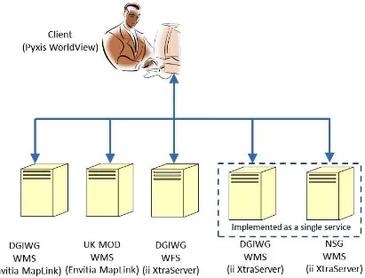
5.1 Architecture
The architecture adopted by the Profile Interoperability aspect of the CCI thread is illustrated in Figure 1. The architecture shows components from Pyxis Innovation, Inc. Envitia Ltd. and Interactive Instruments GmbH (ii).
Figure 1. Testbed-10 CCI Profile Interoperability Architecture
specifically WMS, which facilitated testing of the profile. It should be noted that
6 Comparison of WMS Profiles
The following tables present the requirements of the WMS profiles against each operation offered by the service. Each row presents the
requirements against the relevant operation and parameter in order to highlight the similarities and differences between the profiles. The phrase “Supported as specified in the OGC WMS 1.3 Standard” has been used to indicate that the profile does not make changes to the requirement specified in the base standard.
6.1 GetCapabilities Operation
Table 1. WMS GetCapabilities operation comparison
Parameter or Metadata
element
Sub-element or
property
NSG Profile Comment DGIWG Profile Comment1 UKMOD Profile Comment
Service Abstract Includes a security classification identified at the top of the security
field.
DGIWG profile requires a conforming WMS server to include the following information in the abstract element of the service metadata: "This service implements the DGIWG WMS profile 1.3 version 1.0."
Additional Clarification: "Use of security classification is allowable, but not mandatory in the DGIWG profile" Additional Clarification: “DGIWG determines, identification of source CRS and
transformation within the GetCapabilities Abstract to be an inappropriate location for
this information.”
Requires inclusion of text identifying the source CRS
and transformation used.
Service Access
Constraints
Populate the wms:AccessConstraints element as you would the
classification markings of a classified document. This defines the highest classification level of the content accessible through the WMS service. This may also include Fees.
Supported as specified in the OGC WMS 1.3 Standard, though likely to require support
for multinational classification systems.
Additional clarification: “For the use of the DGIWG profile in an NATO environment, the common NATO classification scheme
has to be applied.”
Supported as specified in the OGC WMS 1.3 Standard.
Service LayerLimit Supported as specified in the OGC
WMS 1.3 Standard.
If a DGIWG WMS server implements the LayerLimit parameter, it shall not be less
than 20.
10 Copyright © 2014 Open Geospatial Consortium.
Service MaxWidth
and
MaxHeight
The MaxWidth and MaxHeight shall be greater or equal to 800 pixels.
The MaxWidth and MaxHeight shall be greater or equal to 800 pixels.
If omitted then MaxWidth and MaxHeight imply no limit
on the parameters. If included MaxHeight and MaxWidth shall not be
less than 800.
Layer Abstract The Abstract element is not inherited
by child Layers.
Supported as specified in the OGC WMS 1.3 Standard.
The DGIWG profile however is not clear on this and thus it is recommended that the profile be updated clarify the inheritance
requirements.
Supported as specified in the OGC WMS 1.3 Standard.
Style General If only a single style is available, that
style is known as the “default” style and need not be advertised by the server. Style declarations are inherited by child Layers. A child shall not redefine a Style with the same Name as one inherited from a parent. A child may define a new Style with a new Name that is not available for the parent Layer.
DGIWG profile states that “A DGIWG WMS server shall always provide at least one style element even if only a default style
is advertised.”
This profile mandates that a Named Layer must have at
least one Style element.
Style Format Supported as specified in the OGC
WMS 1.3 Standard.
DGIWG profile allows PNG, GIF or JPEG as a minimum.
EX_Geogra phicBoundi
ngBox
General Every named Layer shall have
exactly one
EX_GeographicBoundingBox element that is either stated explicitly
or inherited from a parent Layer.
DGIWG profile is not clear on whether it requires the CRS of the
EX_GeographicBoundingBox to be stated explicitly or inherited from a parent layer.
Additional clarification: “The DGIWG WMS profile states no further requirement
as already defined in the base standard. Recommendation to update DGIWG profile
to clarify this aspect.”
UKMOD profile mandates that every Layer whether Named or Category must have an explicit CRS for the
12 Copyright © 2014 Open Geospatial Consortium.
BoundingB ox
CRS The NSG provides the following
profiling instruction "To be consistent with the DGIWG WMS 1.3 Profile, CRS elements shall be stated explicitly and not inherited from a parent layer. The service shall
support the following Coordinate Reference Systems, and use the following associated keywords 1) to
designate them in its responses, and 2) to process the clients’ requests [WGS84 geographic longitude, then
atitude, expressed in decimal degrees:CRS:84], [WGS84 geographic latitude, then longitude,
expressed in decimal degrees:EPSG:4326] and [World Mercator projection:EPSG:3395]. The NSG also provides the following
profiling instruction "Among the following Coordinate Reference Systems, the service shall support all
those which validity zone overlaps data published by the service. For each of these Coordinate Reference
Systems, the following associated keywords shall be used 1) to designate them in its responses, and
2) to process the clients’ requests" [UTM projections over WGS84
(north zones): EPSG:32601 to EPSG:32660], [UTM projections
over WGS84 (south zones): EPSG:32701 to EPSG:32760], [UPS projection over WGS84 (north zone):
j i
At a minimum, DGIWG profile requires support of EPSG:4326, EPSG:3395 and
CRS:84
In a Named Layer it is appropriate Worldwide CRS
are used in accordance with the previous DGIWG WMS profile [7] and UTM/UPS projections which the layer
data covers. In addition to this it is recommended that for local
operations (such as UK Operations which is
illustrated by the EPSG:27700 in the example) such projections or datums should be added if the Named Layer data covers these CRS. When adding CRS other than those
based on WGS 1984 to a Named Layer correct use of
Geodetic Datum Transformations must be
applied as per OGC document 09-187 and recorded in the <Abstract>
BoundingB ox
"minx miny maxx maxy"
If the Layer CRS is "CRS:1" (Map CS; see B.2), then
the BoundingBox units are pixels, the origin is at the upper left, the first (x)
axis increases to the right, and the second (y) axis increases toward the
bottom.
Supported as specified in the OGC WMS 1.3 Standard.
Supported as specified in the OGC WMS 1.3 Standard.
MetadataU RL
General "The wms:MetadataURL element
shall point to an NMIS instance document for that layer. That document includes the ISM elements
for that layer. The result is a capabilities document with both an overall security marking and “portion
markings” at the layer level. It follows the conventions for document marking so it will be intuitive to the user community.
See AccessConstraints above."
The DGIWG WMS profile states no further requirement as already defined in the base standard. Recommendation to update DGIWG profile to clarify this aspect.
It is foreseeable that DGIWG WMS will reference metadata documents based on the DGIWG metadata specification.
It is foreseeable that UKMOD WMS will reference metadata
14 Copyright © 2014 Open Geospatial Consortium.
FeatureList URL
General A server may use
a FeatureListURL element to point to a list of the features represented in a
Layer. FeatureListURL is not inherited by child layers.
DGIWG requires that If the
GetCapabilities document identifies support for FeatureListURL then the list of features
that are in the particular layer shall be resolvable through the provided URL. Additional clarification: “DGIWG might
want to define either a structure for the FeatureListURL or at least provide an
example”
Supported as specified in the OGC WMS 1.3 Standard.
DataURL General A server may use DataURL to offer a
link to the underlying data represented by a particular layer.
DGIWG requires that If the
GetCapabilities document identifies support for DataURL then the underlying data of the particular layer shall be resolvable through
the provided URL.
Supported as specified in the OGC WMS 1.3 Standard.
Layer General A Layer may have zero or more of
the following XML attributes: queryable, cascaded, opaque, noSubsets, fixedWidth, fixedHeight.
All of these attributes are optional and default to 0. Each of these attributes can be inherited or replaced
by subsidiary layers
DGIWG profile requires that a DGIWG WMS server shall provide the XML Attributes: queryable, cascaded, Opaque,
noSubsets, fixedWidth and fixedHeight.
Queryable attribute must be provided however, a Layer
may have zero or more of the following XML attributes: cascaded, opaque,
noSubsets, fixedWidth, fixedHeight.
Layer queryable DGIWG Web Map Service (WMS)
1.3 Profile: All layers publishing vector data and coverage data shall
be queryable.
DGIWG Web Map Service (WMS) 1.3 Profile: All layers publishing vector data and
coverage data shall be queryable.
Requires all services offering vector layers to be
Layer noSubsets Allows both subsettable and non-subsettable layers. When set to a true
value, noSubsets indicates that the server is not able to make a map of a geographic area other than the layer's
bounding box.
The DGIWG Web Map Service (WMS) 1.3 Profile: All layers published by the service shall be subsettable and resizable - enables the client to benefit from service-oriented
data dissemination.
All layers published by the service shall be subsettable, resizable and not defined as
opaque.
Format General Every server shall support the default
text/xml format defined in Annex A. Support for other formats is optional. If the request specifies a format not supported by the server, the server shall respond with the default text/xml format.
DGIWG Requirement 3 states that "A DGIWG WMS server shall support text/xml
and text/html as output formats for the GetCapabilities and the GetFeatureInfo
Operations"
The default format for the response to a GetCapabilities must be “text/xml”. Other formats
may be present, but must include as a minimum
16 Copyright © 2014 Open Geospatial Consortium.
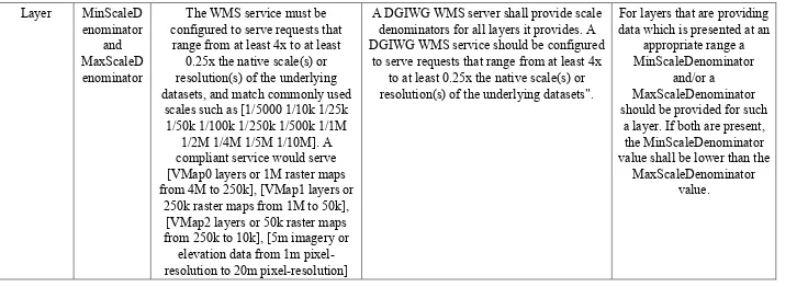
The WMS service must be configured to serve requests that range from at least 4x to at least
0.25x the native scale(s) or resolution(s) of the underlying datasets, and match commonly used
scales such as [1/5000 1/10k 1/25k 1/50k 1/100k 1/250k 1/500k 1/1M
1/2M 1/4M 1/5M 1/10M]. A compliant service would serve [VMap0 layers or 1M raster maps from 4M to 250k], [VMap1 layers or
250k raster maps from 1M to 50k], [VMap2 layers or 50k raster maps from 250k to 10k], [5m imagery or
elevation data from 1m pixel-resolution to 20m pixel-pixel-resolution]
A DGIWG WMS server shall provide scale denominators for all layers it provides. A DGIWG WMS service should be configured
to serve requests that range from at least 4x to at least 0.25x the native scale(s) or resolution(s) of the underlying datasets".
For layers that are providing data which is presented at an
appropriate range a MinScaleDenominator
and/or a
MaxScaleDenominator should be provided for such
a layer. If both are present, the MinScaleDenominator value shall be lower than the
MaxScaleDenominator value.
6.2 GetMap Operation
Table 2. WMS GetMap operation comparison
Parameter or Metadata
element
Sub-element or property
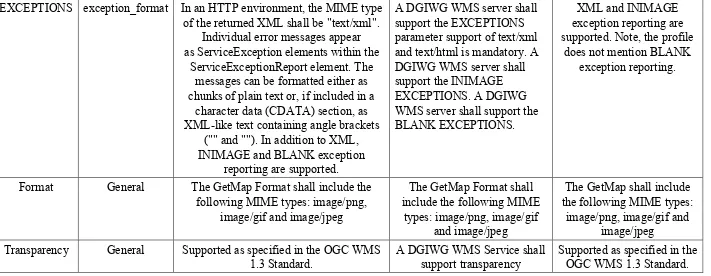
EXCEPTIONS exception_format In an HTTP environment, the MIME type of the returned XML shall be "text/xml".
Individual error messages appear as ServiceException elements within the
ServiceExceptionReport element. The messages can be formatted either as chunks of plain text or, if included in a
character data (CDATA) section, as XML-like text containing angle brackets
("" and ""). In addition to XML, INIMAGE and BLANK exception
reporting are supported.
A DGIWG WMS server shall support the EXCEPTIONS parameter support of text/xml and text/html is mandatory. A DGIWG WMS server shall support the INIMAGE EXCEPTIONS. A DGIWG WMS server shall support the BLANK EXCEPTIONS.
XML and INIMAGE exception reporting are supported. Note, the profile
does not mention BLANK exception reporting.
Format General The GetMap Format shall include the
following MIME types: image/png, image/gif and image/jpeg
The GetMap Format shall include the following MIME
types: image/png, image/gif and image/jpeg
The GetMap shall include the following MIME types:
image/png, image/gif and image/jpeg
Transparency General Supported as specified in the OGC WMS
1.3 Standard.
A DGIWG WMS Service shall support transparency
Supported as specified in the OGC WMS 1.3 Standard.
6.3 GetFeatureInfo Operation
Table 3. WMS GetFeatureInfo operation comparison
Parameter or Metadata
element
Sub-element or property
18 Copyright © 2014 Open Geospatial Consortium.
Transparency General Supported as specified in the OGC WMS
1.3 Standard.
A DGIWG WMS Service shall support transparency
Supported as specified in the OGC WMS 1.3 Standard.
EXCEPTIONS exception_format In an HTTP environment, the MIME type of the returned XML shall be "text/xml".
Individual error messages appear as ServiceException elements within the
ServiceExceptionReport element. The messages can be formatted either as chunks of plain text or, if included in a
character data (CDATA) section, as XML-like text containing angle brackets
("" and "")
DGIWG requirement 29 states that "A DGIWG WMS server shall support the
EXCEPTIONS parameter support of text/xml and text/html is mandatory".
Supported as specified in the OGC WMS 1.3 Standard.
Format General Supported as specified in the OGC WMS
1.3 Standard.
A DGIWG WMS server shall support text/xml and text/html
as output formats for the GetCapabilities and the GetFeatureInfo Operations
The service shall support at least one of the following MIME types for the
INFO-FORMAT Parameter text/xml, text/html and
text/plain
7 Comparison of WFS Profiles
The following tables present the requirements of the WFS profiles against each operation offered by the service. Each row presents the
“Supported as specified in the OGC WFS 1.1 Standard” or “Supported as specified in the OGC WFS 2.0. Standard” has been used to indicate that the profile does not make changes to the requirement specified in the base standard.
7.1 Basic WFS – GetCapabilities Operation
Table 4. Basic WFS – GetCapabilities operation comparison
Parameter or Capability
DGIWG UKMOD
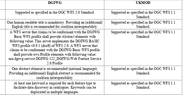
Name Supported as specified in the OGC WFS 2.0 Standard. Supported as specified in the OGC WFS 1.1
Standard.
Title One human readable title is mandatory. Providing an (additional)
English title is recommended for coalition interoperability.
Supported as specified in the OGC WFS 1.1 Standard.
Abstract A WFS server that claims to be conformant with the DGIWG
Basic WFS profile shall provide Abstract elements with following value: This server implements the DGIWG BASIC
WFS profile v0.9.1 (draft) of WFS 2.0. A WFS server that claims to be conformant with the DGIWG Basic WFS profile
shall provide ows:Profile elements with following value: urn:dgiwg:service:DGIWG 122_DGIWG-Web Feature Service
2.0 Profile
Supported as specified in the OGC WFS 1.1 Standard.
Abstract One abstract element is recommended (national language).
Providing an (additional) English abstract is recommended for coalition interoperability.
Supported as specified in the OGC WFS 1.1 Standard.
Keywords At least one keyword is required for each feature type to
facilitate data discovery in catalogues. Keywords can be duplicated in multiple languages.
20 Copyright © 2014 Open Geospatial Consortium.
DefaultCRS A service implementing the DGIWG WFS profiles shall provide
their data in EPSG:4326. Optionally data may be provided in additional CRSs, depending on national requirements.
Supported as specified in the OGC WFS 1.1 Standard.
OtherCRS A service implementing the DGIWG WFS profiles shall provide
their data in EPSG:4326. Optionally data may be provided in additional CRSs, depending on national requirements.
Supported as specified in the OGC WFS 1.1 Standard.
NoCRS The wfs:NoCRS element shall be used for feature types that
have no spatial properties.
Supported as specified in the OGC WFS 1.1 Standard.
OutputFormats If this optional element is not specified, then all the result
formats listed for the GetFeature operation are assumed to be supported.
Supported as specified in the OGC WFS 1.1 Standard.
WGS84BoundingBox This knowledge aids client applications by letting them know
where they should query in order to have a high probability of finding feature data.
Supported as specified in the OGC WFS 1.1 Standard.
MetadataURL When MetadataURL is used, the xlink:href element shall be used
to reference any metadata. In an SDI like architecture, a link to the metadata resource available on a CSW server should be
provided.
Supported as specified in the OGC WFS 1.1 Standard.
ExtendedDescription A WFS may add elements to the description of a feature type,
without having to redefine the capabilities schema, using the wfs:ExtendedDescription element.
Abstract A WFS server that claims to be conformant with the DGIWG Transactional (Locking) WFS profile shall provide Abstract elements with the following value: This server implements the DGIWG Transactional (Locking) WFS profile v0.9.1 (draft) of WFS 2.0. A WFS server that claims to be conformant with the
DGIWG Transactional (Locking) WFS profile shall provide ows:Profile elements with the following value:
urn:dgiwg:service:DGIWG 122_DGIWG-Web Feature Service 2.0 Profile
Supported as specified in the OGC WFS 1.1 Standard.
7.2 Basic WFS – DescribeFeatureType Operation
Table 5. Basic WFS – DescribeFeatureType operation comparison
Parameter or Capability
DGIWG UKMOD
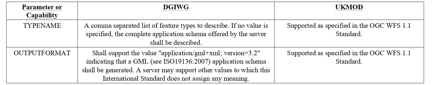
TYPENAME A comma separated list of feature types to describe. If no value is
specified, the complete application schema offered by the server shall be described.
Supported as specified in the OGC WFS 1.1 Standard.
OUTPUTFORMAT Shall support the value "application/gml+xml; version=3.2"
indicating that a GML (see ISO19136:2007) application schema shall be generated. A server may support other values to which this
International Standard does not assign any meaning.
22 Copyright © 2014 Open Geospatial Consortium.
7.3 Basic WFS – GetFeature Operation
Table 6. Basic WFS – GetFeature operation comparison
Parameter or Capability
DGIWG UKMOD
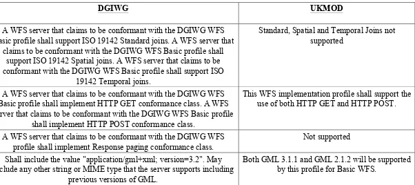
Filter A WFS server that claims to be conformant with the DGIWG WFS
Basic profile shall support ISO 19142 Standard joins. A WFS server that claims to be conformant with the DGIWG WFS Basic profile shall
support ISO 19142 Spatial joins. A WFS server that claims to be conformant with the DGIWG WFS Basic profile shall support ISO
19142 Temporal joins.
Standard, Spatial and Temporal Joins not supported
Bindings A WFS server that claims to be conformant with the DGIWG WFS
Basic profile shall implement HTTP GET conformance class. A WFS server that claims to be conformant with the DGIWG WFS Basic profile
shall implement HTTP POST conformance class.
This WFS implementation profile shall support the use of both HTTP GET and HTTP POST.
Paging A WFS server that claims to be conformant with the DGIWG WFS
profile shall implement Response paging conformance class.
Not supported
outputFormat Shall include the value "application/gml+xml; version=3.2". May
include any other string or MIME type that the server supports including previous versions of GML.
7.4 Basic WFS – GetPropertyValue Operation
Table 7. Basic WFS – GetPropertyValue operation comparison
Parameter or Capability
DGIWG UKMOD
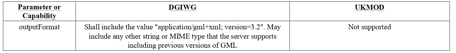
outputFormat Shall include the value "application/gml+xml; version=3.2". May
include any other string or MIME type that the server supports including previous versions of GML
Not supported
7.5 Basic WFS – ListStoredQueries Operation
Table 8. Basic WFS – ListStoredQueries operation comparison
Parameter or Capability DGIWG UKMOD
General Shall be supported by a Basic WFS Not supported
7.6 Basic WFS – DescribeStoredQueries Operation
Table 9. Basic WFS – DescribeStoredQueries operation comparison
Parameter or Capability DGIWG UKMOD
24 Copyright © 2014 Open Geospatial Consortium.
7.7 Transactional WFS – GetCapabilities Operation
Table 10. Transactional WFS – GetCapabilities operation comparison
Parameter or Capability DGIWG UKMOD
Abstract A WFS server that claims to be conformant with the DGIWG
Transactional (Locking) WFS profile shall provide Abstract elements with the following value: This server implements the
DGIWG Transactional (Locking) WFS profile v0.9.1 (draft) of WFS 2.0. A WFS server that claims to be conformant with
the DGIWG Transactional (Locking) WFS profile shall provide ows:Profile elements with the following value: urn:dgiwg:service:DGIWG 122_DGIWG-Web Feature
Service 2.0 Profile
Supported as specified in the OGC WFS 1.1 Standard.
7.8 Transactional WFS – GetFeatureWithLock Operation
Table 11. Transactional WFS – GetFeatureWithLock operation comparison
Parameter or Capability DGIWG UKMOD
General This operation is optional This operation is optional
7.9 Transactional WFS – LockFeature Operation
Table 12. Transactional WFS – GetFeatureWithLock operation comparison
General A WFS server that claims to be conformant with the DGIWG Transactional (Locking) WFS profile shall
implement at least the LockFeature operation.
Copyright © 2014 Open Geospatial Consortium. 26
8 Discussion
The various profiles were successfully implemented in the testbed and a number of observations made. This section presents those observations. A screenshot showing an overlay of topographic and maritime data from some of the services discussed in this report is presented in Figure 2. The screenshot highlights a key benefit of profile
interoperability and that is that it is possible to bring together data from disparate sources across a community.
Figure 2. The OWS Client with topographic data from the DGIWG WFS overlaid on maritime data from the UK MOD WMS
8.1 WMS
The DGIWG WMS profile was implemented using two different products in the testbed, namely Envitia MapLink and Interactive Instruments GmbH XtraServer. The former was also configured to conform to the UK MOD WMS profile, whereas the latter was also configured to conform to the NSG WMS Profile. Configuration of the products to the referenced profiles was overall successful, and it was observed that both the UK MOD profile and the NSG WMS profile are generally consistent with the DGIWG WMS profile. There are, however, some issues worth noting.
implementation to the profile. As the unavailability of metadata is common, the requirement to always provide MetadataURL elements should therefore be considered across all of the referenced profiles and implementers encouraged to populate it.
With regard to <MetadataURL> it is also worth noting that the NSG WMS profile requires the metadata to be based on NSG Metadata Implementation Specification (NMIS), whereas (although not specified) the DGIWG Metadata Foundation would be more appropriate for use with implementations of the DGIWG WMS profile. Similarly, the UK MOD Geospatial Metadata Profile (MGMP) would be more appropriate for use with implementations of the UK MOD WMS profile.
The DGIWG profile lists a minimum set of CRS and alignment of the NSG profile to the DGIWG CRS requirement means that no significant issues are likely. The UK MOD profile recommends that “Named Layers support a Worldwide CRS” but does not mandate a specific CRS. To reduce the possibility of implementations selecting a
Worldwide CRS that is not supported by the other referenced profiles, it is necessary for the UK MOD profile to require that at least one of the CRS required by the DGIWG profile be offered by services conforming to the UK MOD profile. One such appropriate CRS that could be used across all of the three referenced profiles would be the World Geodetic System 1984 (also referred to as WGS84 or EPSG:4326), which is arguably the most widely used Worldwide CRS – used in smartphones, surveying equipment, satellite navigation systems, search engines and other mass market applications.
The testbed observed that the previous version of the DGIWG WMS profile forbade hierarchical layers on the grounds that most clients and servers did not support them [7]. However, the draft version of the profile (which is the reference DGIWG profile for this testbed) states that “the <Layer> element can enclose child elements providing metadata about the Layer. The values of some of these elements can be inherited by subsidiary layers” [4]. Both Envitia MapLink and XtraServer were configured to allow all data carrying layers to appear as direct children of the root layer. Testbed participants noted that allowing hierarchical layers is a useful part of the WMS standard and current client applications are typically able to cope with the capability.
8.2 WFS
28 Copyright © 2014 Open Geospatial Consortium.
Filter 2.0 objects, a Simple WFS 2.0 can offer a StoredQuery that receives Filter 1.1 objects. To enable cross community interoperability, it may be necessary to change the WFS 2.0 standard to require a Simple WFS to offer an additional StoredQuery that
accepts Filter 1.1 objects. This would make WFS 2.0 more “backward compatible” than it currently is. Alternatively, and possibly more efficiently, it may be left up to future WFS 2.0 profiles to require implementation of such StoredQueries.
In exploring the DGIWG WFS 2.0 profile, an instance of the XtraServer product by Interactive Instruments GmbH was successfully configured according to the profile. All of the requirements specified in the profile were found to be understandable and sound. The requirements and most recommendations could be easily configured, changes in the software were not necessary. The only exceptions were support for response paging and joins. A number of issues concerning the clarity of the requirements were found in
Requirement 21 of the profile, which specifies constraints to apply on specific operations. The issues, which are listed next, seem to suggest that the profile is a work-in-progress:
1. Constraint name "CountDefault" is mandatory (M), though the Description allows for leaving it out.
2. There is no obligation (e.g. mandatory or optional) value for "SortLevelLimit".
3. Constraint name "ResolveLocalScope" is mandatory (M), though the Description allows for leaving it out.
4. The DGIWG values constraint column specifies "To be discussed!" for the "QueryExpression" constraint
Since the DGIWG tests are based on the conformance classes defined in the WFS standard of the International Organisation for Standardisation (ISO 19142), an attempt has been made to run the configured service against the Compliance and Interoperability Testing Initiative (CITE) Test Suite provided by OGC. This was not successful due to errors in the CITE tests. The observed issues have been reported to the CITE
administrators.
organisations e.g. US NGA and UK MOD would also need to provide similar URI schemes to support identification of StoredQuery functions.
9 Conclusions
This report has presented a comparative analysis of NSG, DGIWG and UK MOD profiles of WMS and WFS. The analysis considered operations offered by each service and the parameters accepted or capabilities offered. The report has also presented observations from the implementation of the profiles within the Testbed-10 testbed. The discussion has also been informed by feedback from the DGIWG community.
This report concludes that there is significant interoperability between the NSG, DGIWG and UK MOD profiles of WMS. The high degree of interoperability is due to the three profiles being based on the same versions of WMS and supporting common capabilities such as worldwide CRS, image formats and data encodings. Unsurprisingly there are some capabilities that are specific to each profile, for example, the mandatory support of specific CRS by the DGIWG profile. However, the observed common capabilities imply that the profiles are primarily interoperable.
The report also concludes that interoperability between the DGIWG and UK MOD profiles of WFS could be improved significantly if both profiles were based on the same version of WFS. Given that the DGIWG profile of WFS is based on the latest version of the WFS standard, a key recommendation of this report is that a UK MOD profile for version 2.0 of the WFS standard be developed. The complete set of recommendations is presented in the following section.
10 Recommendations
The following recommendations have been identified.
10.1 Offer an Optional StoredQuery in WFS 2.0 for Supporting Filter 1.1 Requests
Currently the Filter 2.0 standard prevents WFS 2.0 from being backwards compatible with WFS 1.1. To help address this issue, Simple WFS based on WFS 2.0 could
optionally implement a StoredQuery for receiving a Filter 1.1 Query and processing it as a WFS 1.1 would.
10.2 Establish a StoredQuery Registry and URI scheme for profiles
30 Copyright © 2014 Open Geospatial Consortium.
10.3 Develop a UK MOD Profile for WFS 2.0
There is limited backwards compatibility between WFS 1.1 and 2.0, therefore some of the factors affecting interoperability between the DGIWG WFS profile (based on WFS 2.0) and the UK MOD WFS profile (based on WFS 1.1) may not be resolvable unless both profiles are grounded on the same version of WFS. Following the March 2014 Technical Committee meeting, Dstl confirmed that the UK MOD are currently considering the adoption of the DGIWG WFS 2.0 profile.
10.4 Offer an Optional WMS Capability for Styling GetFeatureInfo Responses
Although the WMS standard allows for GetFeatureInfo to return responses in different encodings, it however relies on a client application or a separate web service to transform the responses (e.g. for different HTML styling). WMS could offer an optional capability that allows GetFeatureInfo requests to ingest complete or subsets of XSLT scripts to apply to GetFeatureInfo responses. This could be implemented in a similar way to how WMS can ingest SLDs.
10.5 WMS GetFeatureInfo responses should be offered in at least XML format
The DGIWG WMS profile requires services to support text/xml and text/html as output formats for the GetFeatureInfo Operation. The UK MOD requires services to support at least one of the following MIME types for the INFO-FORMAT Parameter text/xml, text/html and text/plain. This means that an implementation of the UK MOD profile could return text/plain responses and remain conformant to the UK MOD profile but not interoperable with the DGIWG profile.
10.6 All WMS profiles should require provision of MetadataURL