Open Geospatial Consortium
Publication Date: 2014-07-16
Approval Date: 2014-05-14
Posted Date: 2014-05-20
Reference number of this document: OGC 14-049
Reference URL for this document: http://www.opengeospatial.net/doc/PER/testbed10/cci-ontology
Category: Public Engineering Report
Editor: Ingo Simonis, Stephane Fellah
OGC
®Testbed 10 Cross Community Interoperability (CCI)
Ontology Engineering Report
Copyright © 2014 Open Geospatial Consortium
To obtain additional rights of use, visit http://www.opengeospatial.org/legal/.
Warning
This document is not an OGC Standard. This document is an OGC Public
Engineering Report created as a deliverable in an OGC Interoperability Initiative and is not an official position of the OGC membership. It is distributed for review and comment. It is subject to change without notice and may not be referred to as an OGC Standard. Further, any OGC Engineering Report should not be referenced as required or mandatory technology in procurements.
Document type: OGC® Engineering Report Document subtype: NA
Abstract
Testbed 10 ontology work focused on:
A general examination of ontologies in the context of OGC data modeling, handling, and organization. Testbed-10 has started to define a consistent set of ontologies implementing solid theoretical foundations and semantics.
The definition of a core ontologies for representing incident information used by Incident Management Systems (IMS) and mapping symbologies used in the emergency and disaster management domain with the goal to improve
interoperability between different IMS symbology sets used across multi-level jurisdiction.
Addressed ontology mapping between hydrology feature models using SPARQL and OWL2.
Keywords
ogcdoc, ogc documents, ows10, ontology, cci, geosparql, hydrology, uml, owl, incident mapping, emergency
Preface
A significant part of the OGC standards development process is the Interoperability Program (IP), which conducts international interoperability initiatives such as Testbeds, Pilot Projects, Interoperability Experiments, and Interoperability Expert Services. These activities are designed to encourage rapid development, testing, validation, demonstration and adoption of open, consensus based standards and best practices.
The OGC Testbed 10 (Testbed-10) is a Testbed within the Interoperability Program. Within Testbed-10, the Cross-Community Interoperability (CCI) thread seeks to build on interoperability within communities sharing geospatial data and advance semantic
mediation approaches for data discovery, access and use of heterogeneous data models and heterogeneous metadata models. This thread explored the creation of domain ontologies and tools to create, assemble, and disseminate geographic data provided voluntarily by individuals. One objective was to build integration across all OGC web services with the intent to provide a better understanding of service content and the relationships or associations that exist between OGC services and resources/content. All ontology related work is documented in this engineering report. The Testbed-10 Virtual Global Gazetteer Engineering Report (OGC document 14-029) contains further
License Agreement
Permission is hereby granted by the Open Geospatial Consortium, ("Licensor"), free of charge and subject to the terms set forth below, to any person obtaining a copy of this Intellectual Property and any associated documentation, to deal in the Intellectual Property without restriction (except as set forth below), including without limitation the rights to implement, use, copy, modify, merge, publish, distribute, and/or sublicense copies of the Intellectual Property, and to permit persons to whom the Intellectual Property is furnished to do so, provided that all copyright notices on the intellectual property are retained intact and that each person to whom the Intellectual Property is furnished agrees to the terms of this Agreement.
If you modify the Intellectual Property, all copies of the modified Intellectual Property must include, in addition to the above copyright notice, a notice that the Intellectual Property includes modifications that have not been approved or adopted by LICENSOR. THIS LICENSE IS A COPYRIGHT LICENSE ONLY, AND DOES NOT CONVEY ANY RIGHTS UNDER ANY PATENTS THAT MAY BE IN FORCE ANYWHERE IN THE WORLD.
THE INTELLECTUAL PROPERTY IS PROVIDED "AS IS", WITHOUT WARRANTY OF ANY KIND, EXPRESS OR IMPLIED, INCLUDING BUT NOT LIMITED TO THE WARRANTIES OF MERCHANTABILITY, FITNESS FOR A PARTICULAR PURPOSE, AND NONINFRINGEMENT OF THIRD PARTY RIGHTS. THE COPYRIGHT HOLDER OR HOLDERS INCLUDED IN THIS NOTICE DO NOT WARRANT THAT THE FUNCTIONS CONTAINED IN THE INTELLECTUAL PROPERTY WILL MEET YOUR REQUIREMENTS OR THAT THE OPERATION OF THE INTELLECTUAL PROPERTY WILL BE
UNINTERRUPTED OR ERROR FREE. ANY USE OF THE INTELLECTUAL PROPERTY SHALL BE MADE ENTIRELY AT THE USER’S OWN RISK. IN NO EVENT SHALL THE COPYRIGHT HOLDER OR ANY CONTRIBUTOR OF
INTELLECTUAL PROPERTY RIGHTS TO THE INTELLECTUAL PROPERTY BE LIABLE FOR ANY CLAIM, OR ANY DIRECT, SPECIAL, INDIRECT OR CONSEQUENTIAL DAMAGES, OR ANY DAMAGES WHATSOEVER RESULTING FROM ANY ALLEGED INFRINGEMENT OR ANY LOSS OF USE, DATA OR PROFITS, WHETHER IN AN ACTION OF CONTRACT, NEGLIGENCE OR UNDER ANY OTHER LEGAL THEORY, ARISING OUT OF OR IN CONNECTION WITH THE IMPLEMENTATION, USE, COMMERCIALIZATION OR PERFORMANCE OF THIS INTELLECTUAL PROPERTY. This license is effective until terminated. You may terminate it at any time by destroying the Intellectual Property together with all copies in any form. The license will also terminate if you fail to comply with any term or condition of this Agreement. Except as provided in the following sentence, no such termination of this license shall require the termination of any third party end-user sublicense to the Intellectual Property which is in force as of the date of notice of such termination. In addition, should the Intellectual Property, or the operation of the Intellectual Property, infringe, or in LICENSOR’s sole opinion be likely to infringe, any patent, copyright, trademark or other right of a third party, you agree that LICENSOR, in its sole discretion, may terminate this license without any compensation or liability to you, your licensees or any other party. You agree upon termination of any kind to destroy or cause to be destroyed the Intellectual Property together with all copies in any form, whether held by you or by any third party. Except as contained in this notice, the name of LICENSOR or of any other holder of a copyright in all or part of the Intellectual Property shall not be used in advertising or otherwise to promote the sale, use or other dealings in this Intellectual Property without prior written authorization of LICENSOR or such copyright holder. LICENSOR is and shall at all times be the sole entity that may authorize you or any third party to use certification marks, trademarks or other special designations to indicate compliance with any LICENSOR standards or specifications.
This Agreement is governed by the laws of the Commonwealth of Massachusetts. The application to this Agreement of the United Nations Convention on Contracts for the International Sale of Goods is hereby expressly excluded. In the event any provision of this Agreement shall be deemed unenforceable, void or invalid, such provision shall be modified so as to make it valid and enforceable, and as so modified the entire Agreement shall remain in full force and effect. No decision, action or inaction by LICENSOR shall be construed to be a waiver of any rights or remedies available to it.
Contents
Page1 Introduction ... 1
1.1 Scope ... 1
1.2 Document contributor contact points ... 1
1.3 Revision history ... 2
1.4 Future work ... 2
1.4.1 Ontology development ... 2
1.4.2 GeoSPARQL 2.0 ... 2
1.4.3 Core LEAPS and E&DM Domain Ontologies ... 3
1.4.4 Emergency and Disaster Management Mapping Symbologies ... 3
1.5 Forward ... 3
6 Core Geospatial Ontologies ... 9
6.1 Overview ... 9
6.4.1 Minimal ontological commitment ... 13
6.4.2 Modularization of ontologies ... 13
6.4.3 Reusability of ontologies ... 14
6.4.4 Understandability ... 14
6.5 OWS10 Geospatial Ontologies overview ... 14
6.5.1 Common Microtheory ... 17
6.5.2 Mereotopology Microtheory ... 17
6.5.3 Temporal Microtheory ... 17
6.5.4 Spatial Microtheory ... 18
6.5.5 Measures microtheory ... 18
6.5.6 Event microtheory ... 19
6.5.7 Feature microtheory ... 19
6.6 Deployment information ... 19
6.7.1 Path to standardization ... 19
6.7.2 GeoSPARQL 2.0 ... 20
7 Incident ontology for E&DM ... 20
7.1 Overview ... 20
7.2 Core incident ontology overview ... 21
7.3 Controlled vocabulary in the emergency and disaster management domain ... 23
8 Emergency and Disaster Management Symbology ... 25
8.1 Introduction ... 25
8.2 Semiology of Maps ... 27
8.3 Symbol Types ... 27
8.4 Symbol Comprehension ... 27
8.4.1 Theory of Affordances and Other Cognitive Factors ... 28
8.4.2 Culture and Gender ... 28
8.4.3 Sensory Issues and Differences ... 28
8.5 FGDC HSWG Symbol Set ... 29
8.6 Symbology ontology ... 29
8.7 Datasets investigated ... 31
8.8 Recommendations ... 31
9 Hydro Model Interoperability ... 32
Figures
Page Figure 1: Overview of the Testbed-10 OGC ontologies ... 15Figure 2: Microtheory excerpt ... 17
Figure 3: Core incident ontology model ... 22
Figure 4: Semantic layer with adapters to the core incident model and derived profiles ... 23
Figure 5: Homeland security symbology for natural events ... 30
Tables
Table 1: HSWG Incident taxonomy encoded using incident ontology and SKOS ... 24OGC® Testbed 10 Cross Community Interoperability (CCI)
Ontology Engineering Report
1 Introduction
1.1 Scope
Testbed-10 ontology work focused on three aspects: First, the general examination of ontologies in the context of OGC data modeling, handling, and organization. Though huge efforts have been invested in modeling geographic information by publishing abstract models (ISO 191xx) and implementation specifications for these models (GML, KML, etc.), as well as application schemas (e.g. CityML), no implementations of these abstract models using taxonomy languages (SKOS) and ontology languages such as RDF/S or OWL have been developed in OGC. Testbed-10 has started to define a consistent set of ontologies implementing solid theoretical foundations and semantics. Second, Testbed-10 examined the definition of a core ontologies for representing incident information used by Incident Management Systems (IMS) and mapping symbologies used in the emergency and disaster management domain with the goal to improve interoperability between different IMS symbology sets used across multi-level jurisdiction.
Third and fully documented as part of the hydrology engineering report, Testbed-10 addressed ontology mapping between hydrology feature models using SPARQL and OWL2.
1.2 Document contributor contact points
All questions regarding this document should be directed to the editor or the contributors:
Name Organization
Ingo Simonis iGSI GmbH
Stephane Fellah Image Matters LLC
1.3 Revision history
Date Release Editor Primary clauses modified
Description
2014-04-27 0.1 IS all all
2014-05-02 0.2 IS 6 Ontology work added
2014-05-06 1.0 IS All Final version
2014-05-14 1.1 IS 8 Additional information on symbology mapping and recommendations for future activities added
2014-05-16 1.2 Stephane Fellah
All Reorganization of Incident and Symbology related sections.
1.4 Future work
Future work in envisioned as follows:
1.4.1 Ontology development
The core geospatial ontologies have been result of eight years of Research and Development at Image Matters in the domain of geospatial semantic. Image Matters decided to release these ontologies for the broad community seeking to facilitate semantic interoperability between systems using geospatial information. The logical next steps are a critical review of the provided ontologies and the application of necessary refinements and extensions to achieve a comprehensive set of base ontologies. To favor the adoption of the geospatial ontologies, improve the robustness and completeness of the
microtheories, we suggest for the next testbed exercising the ontologies by converting existing geospatial data into geospatial knowledge, creating catalogs for unit of measures, CRSs and feature types (for gazetteers). The ontologies can also be exercised by creating ontologies for more specialized domain that leverage the core geospatial ontologies, as it was done for this testbed for E&DM. The result of these activities should lead to
identifying best practices and provides a rich set of examples how geospatial ontologies could be used for different vertical communities and be queried using open linked data standards and protocols (Linked Data Platform, GeoSPARQL).
1.4.2 GeoSPARQL 2.0
Based on feedback from the OGC Geospatial Semantic WG and lessons learned from Testbed-10, there is a need to modularize and simplify GeoSPARQL specification. The Testbed-10 geospatial ontologies address many of these aspects (for example
modularization of spatial relations), and could be used as a starting point.
1.4.3 Core LEAPS and E&DM Domain Ontologies
We recommend building a set of core domain ontologies for the law enforcement and public safety as well as the emergency and disaster management domain.
As it is important to accommodate jurisdiction-specific and mission-specific profile requirements, it is necessary to identify key points of interoperability in a given service oriented architecture. As an example, the next test bed might investigate Abu Dhabi Police’s (ADP) System of System (SoS) architecture, defining the required interoperable service APIs and models, as well as the roadmap for achieving a prioritized
implementation of these key interfaces and models. The Abu Dhabi Police have submitted a comprehensive set of domain models to OGC for Law Enforcement and Public Safety (LEAPS). These models can be used to derive a set of foundational ontologies that serve as the basis for interoperability throughout ADP’s system of systems LEAPS domain. The purpose of this task is to formalize and semantically-ground ADP’s LEAPS domain models as ontologies. These ontologies will be built upon OGC’s Geospatial Ontology, and they will define the minimum-essential core set of concepts, properties and relationships for the LEAPS community.
The LEAPS ontologies must be designed to accommodate any jurisdiction/mission profile specific information (taxonomies, specialized concepts and relationships), using the built-in extension mechanisms of OWL. The ontologies will be exercised by building “ontology profiles”, mapping existing ADP data to the new domain ontologies, and accessing these data through GeoSPARQL endpoints (as highly interoperable and useful LEAPS Linked Data).
1.4.4 Emergency and Disaster Management Mapping Symbologies
The definition of the symbol and the incident ontology described in this report addresses the challenges of semantic mapping between different symbologies used in neighboring organizations. During the next testbeds, it is important to further explore this approach with at least two symbol sets. To ensure correct semantics, it is important to develop the formal model for these sets in cooperation with organizations responsible for those symbologies. Otherwise, the risk of incorrect mappings is high.
This approach would allow further refinement of the formal semantic model outlined in this report and in consequence it would allow symbology mediation at conceptual level between different sets.
1.5 Forward
Attention is drawn to the possibility that some of the elements of this document may be the subject of patent rights. The Open Geospatial Consortium shall not be held
responsible for identifying any or all such patent rights.
aware that might be infringed by any implementation of the standard set forth in this document, and to provide supporting documentation.
2 References
The following documents are referenced in this document. For dated references, subsequent amendments to, or revisions of, any of these publications do not apply. For undated references, the latest edition of the normative document referred to applies.
Gazetteer ER https://portal.opengeospatial.org/files/?artifact_id=57226 Hydrology ER: https://portal.opengeospatial.org/files/?artifact_id=57121
3 Terms and definitions
3.1 Attribute <XML>
name-value pair contained in an element
[ISO 19136:2007]
NOTE In this document an attribute is an XML attribute unless otherwise specified.
3.2 client
software component that can invoke an operation from a server
[ISO 19128:2005]
3.3 coordinate
one of a sequence of n numbers designating the position of a point in n-dimensional space
[ISO 19111:2007]
3.4 coordinate reference system
coordinate system that is related to an object by a datum [ISO 19111:2007]
3.5 coordinate system
set of mathematical rules for specifying how coordinates are to be assigned to points [ISO 19111:2007]
3.6 element <XML>
[ISO 19136:2007]
3.7 feature
abstraction of real world phenomena [ISO 19101:2002]
NOTE A feature can occur as a type or an instance. The term "feature type" or "feature instance" should be used when only one is meant.
3.8 feature identifier
identifier that uniquely designates a feature instance
3.9 filter expression
predicate expression encoded using XML [ISO 19143]
3.10 GeoSPARQL
SPARQL with a standardized set of geospatial functions that are needed to manipulate geospatial information.
3.11 interface
named set of operations that characterize the behaviour of an entity [ISO 19119:2005]
3.12 Multipurpose Internet Mail Extensions (MIME) type
media type and subtype of data in the body of a message that designates the native representation (canonical form) of such data
[IETF RFC 2045]
3.13 namespace <XML>
collection of names, identified by a URI reference which are used in XML documents as
element names and attribute names [W3C XML Namespaces]
3.14 operation
specification of a transformation or query that an object may be called to execute [ISO 19119:2005]
3.15 property
3.16 request
invocation of an operation by a client
[ISO 19128:2005]
3.17 response
result of an operation returned from a server to a client
[ISO 19128:2005]
3.18 response model
schema defining the properties of each feature type that can appear in the response to a query operation
NOTE This is the schema of feature types that a client can obtain using the DescribeFeatureType operation (cf. Clause 9).
3.19 schema
formal description of a model [ISO 19101:2002]
NOTE In general, a schema is an abstract representation of an object's characteristics and relations to other objects. An XML schema represents the relationship between the attributes and elements of an XML object (for example, a document or a portion of a document).
3.20 schema <XML Schema>
collection of schema components within the same target namespace
[ISO 19136:2007]
EXAMPLE Schema components of W3C XML Schema are types, elements, attributes, groups, etc.
3.21 server
particular instance of a service
[ISO 19128:2005]
3.22 service
distinct part of the functionality that is provided by an entity through interfaces
[ISO 19119:2005]
3.23 service metadata
metadata describing the operations and geographic information available at a server
3.24 Uniform Resource Identifier
unique identifier for a resource, structured in conformance with IETF RFC 2396 [ISO 19136:2007]
NOTE
The general syntax is <scheme>::<scheme-specified-part>.
The hierarchical syntax with a namespace is <scheme>://<authority><path>?<query>
3.25 Symbol
A “symbol” is essentially a bitmap or vector image that is used to indicate an object or a particular property on a map.
3.26 Symbol Table
A “symbol table” or set of symbol metadata on the other hand denotes a “term referring to the storage of named objects, including line types, layers, text styles and blocks.
4 Conventions
4.1 Abbreviated terms
API Application Program Interface CRS Coordinate Reference System E&DM Emergency & Disaster Management ER Engineering Report
FES Filter Encoding Standard GML Geography Markup Language
GMLSF Simple Feature Geography Markup Language HTTP Hypertext Transfer Protocol
KVP Keyword-Value Pair
RDF Resource Description Framework
SKOS Simple Knowledge Organization System SPARQL SPARQL Protocol and RDF Query Language UML Unified Modelling Language
USGS United States Geological Survey WFS Web Feature Service
XML Extensible Markup Language
4.2 Used parts of other documents
This document uses significant parts of document [OGC 06-121r3]. To reduce the need to refer to that document, this document copies some of those parts with small
5 Introduction
Testbed-10 ontology work focused on three aspects: First, the general examination of ontologies in the context of OGC data modeling, handling, and organization. Though huge efforts have been invested in modeling geographic information by publishing abstract models (ISO 191xx) and implementation specifications for these models (GML, KML, etc. ), as well as application schemas (e.g. CityML), no implementations of these abstract models using taxonomy languages (SKOS) and ontology languages such as RDF/S or OWL have been developed in OGC. Testbed-10 has started to define a consistent set of ontologies implementing solid theoretical foundations and semantics. Second, Testbed-10 examined the definition of a core ontologies for representing incident information used by Incident Management Systems (IMS) and mapping symbologies used in the emergency and disaster management domain with the goal to improve interoperability between different IMS symbology sets used across multi-level jurisdiction.
Third and fully documented as part of the hydrology engineering report, Testbed-10 addressed ontology mapping between hydrology feature models using SPARQL and OWL2.
6 Core Geospatial Ontologies
6.1 Overview
OGC and ISO TC/211 have done tremendous work in modeling geographic information by publishing abstract models (ISO 191xx) and implementation specifications for these models (GML, KML, etc. ), as well as application schemas (e.g. CityML). However there are no implementations of these abstract models using taxonomy languages (SKOS) and ontology languages such as RDF/S or OWL. This situation has created the emergence of ad-hoc working groups outside OGC to create ontologies for geospatial information (often redundant) such as W3C Geo, Ordnance Survey spatial relationships, Geonames ontology and taxonomies for feature types. These ontologies do not follow a
comprehensive and coherent approach based on solid theoretical foundations. We envision that OGC could play a crucial and important role in formalizing and
standardizing geospatial ontologies to enable the “Semantic Geoweb”. OGC has started to make steps in this direction by standardizing the query language for the Semantic Web, GeoSPARQL (extending SPARQL with geospatial functions), however this specification fails to provide a comprehensive set of ontologies to describe geospatial data, and also impose a specific ontology to be used for query language. GML has focused on the structure and syntax of geospatial data, enabling syntactic interoperability of geospatial data, but fails to capture the semantics of the models, including linking to semantic data from other domains.
to integrate heterogeneous geospatial data, and link to datasets from other domains (healthcare, law enforcement, public safety, etc.). Web standards (URI, HTTP) and Semantic Web standards (RDF, RDFS, OWL, SKOS, SPARQL, RIF, Linked Data API, etc.) provide the necessary foundation to enable this level of interoperability on the web. OGC can leverage these standards and develop a set of core ontologies for geospatial information, upon which Community Of Interests (COIs) can build and extend to facilitate the semantic interoperability of cross-domain heterogeneous geospatial information.
During the Testbed-10 effort, Image Matters has identified, designed and formalized a set of modular geospatial core and cross-domain ontologies in OWL (mereo-topology, spatial relations, locations, features, temporal ontologies, geometries, CRS, events, measures, etc.). These “ontology components” provide a core ontological foundation for geospatial information that is universally applicable to any domains. These core
ontologies leverages some of existing standard abstract models (ISO 19xxx), but are modularized and adapted to better leverage the expressiveness of OWL and favor
reusability. The resulting Geospatial Ontology can be used as a starting point for building the OGC ontological foundation for all common geospatial information that could be used across various domains (E&DM, Law Enforcement and Public Safety, Gazetteer, Hydrology, Aviation, etc).
6.2 What is an Ontology?
6.2.1 Definition
Ontologies provide a way to share the semantics of concepts in some area of interests. It is all about common understanding of essential concepts. A generally accepted short definition of ontology is given by Gruber (Gruber, 1993):
An ontology is an explicit specification of a conceptualization.
The term conceptualization is defined as follows:
A conceptualization is the combination of objects, concepts, and other entities
that are assumed to exist in some area of interest and the relationships that hold among them. A conceptualization is an abstract, simplified view of the world that we wish to represent for some purpose.
6.2.2 Benefits of ontology
We can summarize the benefits of ontology as follows:
It provides a common and shared understanding/definition about certain key concepts in the domain
It makes the domain assumptions explicit
Together with ontology description languages (such as RDFS and OWL), it provides a way to encode knowledge and semantics such that the machine can understand
It makes automatics large scale machine processing become possible
6.2.3 OWL
OWL stands for Web Ontology Language, and it is currently the most popular language to use when creating ontologies. OWL started as a research-based of the DAML+OIL Web Ontology Language. W3C created the Web Ontology Working Group in November 2001, and the first working drafts of the abstract syntax, reference and synopsis were published in July 2002. The OWL documents became a formal W3C Recommendation on 10 February 2004. The standardization has triggered the development of OWL ontologies in numerous areas of interests. For example, in the life science community, OWL is extensively used and has become a de-factor standard for ontology development and data exchange.
The numerous contexts in which OWL has been exercised have helped identifying deficiencies in expressiveness and usability in ontology editors. In response to the feedback from real-world users, it was decided that an incremental revision of OWL was needed. A new W3C OWL working group was officially formed in September 2007. On 27 October 2009, OWL 2 has become a W3C standard. OWL 1 is a subset of OWL 2, i.e. an ontology created by using OWL 1 will be recognized and understood by any
application that can understand OWL2.
The W3C OWL 2 Primer has given a good definition of OWL:
The W3C OWL 2 Web Ontology Language (OWL) is a Semantic Web language designed to represent rich and complex knowledge about things, groups of things, and relations between things. OWL is a computational logic-based language such that knowledge expressed in OWL can be reasoned with by computer programs either to verify the consistency of that knowledge or to make implicit knowledge explicit.
The geospatial ontologies defined by this testbed are using OWL 2 standard.
6.3 UML versus OWL modeling
Modeling ontologies is very different than modeling object oriented software artifacts. This section attempts to outline the differences and similarities between UML modeling and OWL modeling.
UML is a notation for modelling object oriented software artifacts. OWL is a notation for knowledge representation. These are two quite different problems so asking about
particular thinking in object oriented terms when working with OWL or RDFS will almost always lead you astray.
To take an example, both OWL and UML have things called "classes" and those classes are related in some sort of hierarchy that you can depict via a diagram. However, they are not the same notion at all.
In UML a class is software object. You can create instances of a class and that creation process has a procedural semantics involving things like assigning values to attributes (aka slots, members). So procedural notions, such as a default value for an attribute which is resolved at construction time, is a simple well-defined thing in UML. Instance objects also have some associated storage so UML distinguishes between containment and association - things are that are stored in the object v. things that are outside the object. Instance objects have a runtime semantic so you can have notions of static values and mutable values.
None of that is true in RDFS or OWL or similar languages. In those cases a class is a category, it is a label given to a set of things in a domain. In OWL terms a class is simply the set of things which are members of that set. So RDFS/OWL has no notion of
instantiating or constructing an instance and so no notion of default values for instance creation. If you have a resource and it meets the criteria for membership of the class then it is a member of that class; if you didn't already know that your resource was in that class then you can derive this information by reasoning. Asserting a property on a
resource (or discovering such an assertion) can lead to you inferring that it is a member of further classes. Resources (in RDFS terms, Individuals in OWL terms) are not things with state, storage or runtime semantics. They are simply identifiers for things in your domain. Assertions about those resources can be made, found or derived but the
resources themselves aren't objects with slots and so notions like static and public/private have no meaning here. This is not a limitation of OWL or RDFS so much as the
fundamental nature of what you are modelling. OWL classes are like labels for concepts, UML classes are like templates that define a runtime object and its storage.
Despite all these differences there is however some connection between both modeling languages. Both UML and OWL are languages for modelling. They are modelling totally different things and so have different capabilities and a completely different approach to semantics but there are some structural similarities. MOF (Meta Object Facility) is the meta-modelling tool that underlay UML. It is a language in which you can express other modelling languages. So UML is specified in MOF. You can do the same for RDFS and OWL - that is, express their metamodels in MOF. This is what ODM (Ontology
This discussion should highlight why modeling ontologies cannot be done by simply converting (automatically or not) UML diagram to OWL. Ontologies are better designed from the ground-up but can be informed by concepts expressed in UML models.
6.4 Design Approach
This section outlines some the key principles used to design the geospatial core ontologies.
6.4.1 Minimal ontological commitment
Our modular design of the ontologies follows the principle of making a minimal
ontological commitment to the nature of concepts and of relationships between concepts. As explained by Thomas Gruber, an ontology should require the minimal ontological commitment sufficient to support the intended knowledge sharing activities. An ontology should make as few claims as possible about the world being modeled, allowing the parties committed to the ontology freedom to specialize and instantiate the ontology as needed (which is often called ontology profile).
Opting for such a minimal approach is made dramatically easier by the vocabulary extension mechanisms offered natively by Semantic Web technology. Applications that require more constrained behavior may define compatible extensions to OWL or SKOS. For example, modelers may coin sub-classes and sub-properties of OWL or SKOS properties, or associate those properties with specific formal axioms. By making a minimal ontological commitment, the ontologies can be applied and reused across multiple Communities of Interests (COIs), thus increasing the rate of wide-spread adoption.
6.4.2 Modularization of ontologies
Quoting Stuckenschmidt and Klein (Stuckenschmidt & Klein, 2004), “ontologies that contain thousands of concepts cannot be created and maintained by a single person”. Modularization helps designers manage complexity by reducing the size of the design problem (Stuckenschmidt, Parent, & Spaccapietra, 2009). We want designers design modules of a size that they can apprehend, and later either integrate these modules into a final repository or build the relationships among modules that support interoperability. This is a typical application of the divide-and-conquer principle.
looking at just few modules, rather than exploring the whole ontology (Stuckenschmidt et al., 2009).
6.4.3 Reusability of ontologies
Reusability is a well-known goal in software engineering. Reuse is most naturally seen as an essential motivation for approaches aiming at building a broader, more generic
repository from existing, more specialized repositories. However, it may also apply to the inverse approaches aiming at splitting an ontology into smaller modules. In this case, the decomposition criterion should be based on the expected reusability of a module, i.e. how well can a module fill the purpose of various applications. Reusability emphasize the need for rich mechanisms to describe module, in a way that maximizes the chances for modules to be understood, selected and used by other services and applications.
6.4.4 Understandability
An obvious prerequisite to the ability to use ontology to understand its content. Whether the content is shown in visual or textual format, understanding is easier if the ontology is small (a module). Small ontologies are undoubtedly preferable if the user is a human being. Size, however is not the only criterion that influences understandability. The way it is structured contributes to improving or decreasing understandability.
6.5 OWS10 Geospatial Ontologies overview
The ontologies are organized into set of microtheories. Microtheory is defined as follows: A microtheory is a coherent and consistent set of facts, ontologies, and rules that describe a specific sub-domain.
The surrounding semantic context of a microtheory binds the microtheory to a well-formed, unified problem space. Microtheories partition the knowledge base into a coherent collection of concepts, facts, and rules pertaining to one limited realm of knowledge domain. Unlike a knowledge base, a microtheory must be free of contradictions. Microtheories can inherit from each other and are organized in a
hierarchy, which also must be consistent (free of contradictions) between microtheories. This microtheoryconsistency requirement is extremely important in the application of ontologies to sophisticated machine reasoning, and is often the downfall of imprecisely crafted ontologies. Thus, the consistency requirement differentiates microtheories from more commonplace, but less rigorous ontologies that are little more than embellished taxonomies.
is available online at http://ows10.usersmarts.com/ows10/ontologies/. This work defines the baseline for future modifications and refinements. The following figure provides an overview of the defined microtheories.
Figure 1: Overview of the Testbed-10 OGC ontologies
Figure 2: Microtheory excerpt 6.5.1 Common Microtheory
The Common Microtheory is composed of ontology modules that are reusable across all other ontologies (not only geospatial). It consists of the following modules:
Upper ontology Collections Identifier Relations Role
These ontologies have been influenced by BFO, DOLCE, SUMO, and ODP (ontologydesignpatterns.org).
6.5.2 Mereotopology Microtheory
Mereotopology is a first-order theory, embodying mereological and topological concepts, of the relations among wholes, parts, parts of parts, and the boundaries between parts [Wikipedia]. Barry Smith, Anthony Cohn and his coauthors Smith and Varzi (Smith, 1996; Varzi, 1996) alone and with others, have all shown that mereotopology can be useful in formal ontology and computer science, by formalizing relations such as contact, connection, boundaries, interiors, holes, and so on. Mereotopology has been most useful as a tool for qualitative spatial-temporal reasoning, with constraint calculi such as the Region Connection Calculus (RCC). We consider this microtheory as foundational for building any geospatial ontologies.
The Mereotopology Microtheory is composed of ontology modules related to topological and mereological concepts and relations. We consider this microtheory as foundational for building any geospatial ontologies.
The initial version consists of the following modules: Topological Objects
Topological Relations Topological Primitives Mereology
6.5.3 Temporal Microtheory
The Temporal Microtheory is composed of ontologies related to temporal concepts and relations. The initial version consists of following group of ontologies:
Temporal topological relations among temporal entities, Temporal reference systems,
Temporal units and quantities (duration, frequency,..).
The microtheory has been influenced by a number of ontologies and models (OWL-Time, ISO 19108, CNTRO 2.0, BFO, SWRL Temporal, NASA SWEET).
6.5.4 Spatial Microtheory
The Spatial Microtheory is composed of ontologies related to spatial concepts and relations. The initial version consists of following modules:
Spatial entities composed of spatial objects inhering spatial qualities and spatial regions.
Spatial relationships (RCC8, Egenhofer, simple features topological relationships, relative relationships).
Geometries (Core geometry, GML geometries, Simple Feature Geometry). CRS and Datum
Place
Spatial properties, quantities and units Spatial Mereology
Some of the ontology modules (geometries, spatial relationships) are the results of modularization of GeoSPARQL ontology and links to GeoSPARQL specification are encoded in the ontology when applicable.
6.5.5 Measures microtheory
The Measures Microtheory is composed of ontologies related to measurements of qualities or quantities. The initial version consists of the following modules:
Measure
Measurement Scale Reference Systems Quantity
Observable Properties
6.5.6 Event microtheory
The event microtheory is composed of ontology modules related to event concepts and relations. It is using the spatial and temporal microtheory to describe time and place of events. The initial version is composed of the following modules:
Event Object Event relations
The microtheory has been influenced by a number of ontologies and models (DOLCE, Event Ontology, F-Model, Simple Event Model). This microtheory was used to describe an ontology for modeling Incident in the context of Emergency and Disaster Management (E&DM).
6.5.7 Feature microtheory
The feature microtheory is used to model OGC Feature Model. It defines the concepts of Feature and FeatureCollection and is derived from the Spatial Object ontology. This ontology expresses geospatial concepts using OGC Feature terminology.
6.6 Deployment information
The ontologies have been deployed at the following endpoint:
http://ows10.usersmarts.com/ows10/ontologies/. The homepage shows the different microtheories with their respective modules. When accessing a module, an ontology documentation is generated automatically from the source ontology. All the ontologies have been licensed under Creative Commons 3.0 Attribution 3.0 United States. Source ontology can be accessed in RDF/XML or Turtle format from the documentation page.
6.7 Next Steps
The core geospatial ontologies have been result of eight years of Research and Development at Image Matters in the domain of geospatial semantic. Image Matters decided to release these ontologies for the broad community seeking to facilitate semantic interoperability between systems using geospatial information. The intent is to bootstrap the Geospatial Semantic Web, by providing an initial candidate geospatial ontologies for standardization. We think a joint effort between OGC and W3C would be the right venue to bring this work to maturation and standardization due to their expertise both in
geospatial domain and semantic web respectively.
6.7.1 Path to standardization
To favor the adoption of the geospatial ontologies, improve the robustness and completeness of the microtheories, we suggest for the next testbed exercising the ontologies by converting existing geospatial data into geospatial knowledge, creating catalogs for unit of measures, CRSs and feature types (for gazetteers). The ontologies can also be exercised by creating ontologies for more specialized domain that leverage the core geospatial ontologies, as it was done for this testbed for E&DM. The result of these activities should lead to identifying best practices and provides a rich set of examples how geospatial ontologies could be used for different vertical communities and be queried using open linked data standards and protocols (Linked Data Platform, GeoSPARQL).
6.7.2 GeoSPARQL 2.0
Based on feedback from the OGC Geospatial Semantic WG and lessons learned from Testbed-10, there is a need to modularize and simplify GeoSPARQL specification. The Testbed-10 geospatial ontologies address many of these aspects (for example
modularization of spatial relations), and could be used as a starting point. GeoSPARQL provides a geospatial extension of SPARQL by defining geospatial function extensions and data types (in the same way Spatial SQL extends SQL). GeoSPARQL could be simplified by clearly defining geospatial functions using SPARQL Service Description vocabulary standard and the geospatial datatypes (WKT Literal and GML Literal). The query language should be independent of the ontology describing geospatial concepts (the same way Spatial SQL is independent of relational models). We believe that this simplification and modularization of the specification will foster the adoption of the specification to a larger community.
There is also a need to describe the capabilities of GeoSPARQL. These descriptions provide a mechanism by which a client or end user can discover information about the SPARQL service such as supported extension functions and details about the available geospatial dataset, supported CRSs, inferences supported. There are a number of standards that already exists to describe SPARQL endpoint such as the W3C SPARQL 1.1 Service Description, VoiD and DCAT. These standards will be adapted to
accommodate description of GeoSPARQL endpoints, by defining profiles and best practices. The next testbed should demonstrate the feasibility and robustness of the approach by implementing the specifications.
We believe that this simplification and modularization of the specification will foster the adoption of the specification to a larger community.
7 Incident ontology for E&DM
7.1 Overview
local jurisdictional levels to respond to emergency incidents that may pose an immediate security threat to human life and/or the flow of commerce. The current systems face the following challenges:
Analysts and operators need to quickly triage, fuse, connect dots, detect patterns, infer insights, and make sense of the flow of incident information to get an unambiguous Common Operational Picture
Need to integrate and interpret incidents, observations, mutual aid requests, alerts, etc. generated across a multi-agency, multi-jurisdictional spectrum
Limited interoperability between agencies due to different protocols, taxonomies, models and representations (stovepipes are still there!)
The current data-centric approach mainly based on syntactic and structural approach imposes a huge cognitive burden on the user to make sense of the large volume and varieties of information.
Data model standardization relies upon homogeneous data description and organization. This imposes strict adherence to a standard that is defined at the syntactic-schematic level, whereupon it’s harder to achieve consensus and less flexible. Modelers struggle between producing simpler models for which it is easier to gain consensus, but harder to achieve desired business reality, versus those seeking richer models that are closer to reality but have unwanted complexity.
Data-centric approaches increase the chance for multiple interpretations and
misinterpretations of data. Data interpretation requires knowledge of its semantics (e.g., meanings, significance, relevance, etc.) and surrounding context. Data-centric approaches are unable to capture these semantics and context, which are in turn required for
automated fusion, analytics, and reasoning.
To address these challenges, we adopted a centric approach. The knowledge-based approach employs a standards-knowledge-based formal, sharable framework (RDF, OWL, SPARQL) that provides a conceptual domain model to accommodate various business needs.Decentralized model extensions can be accommodated without adversely affecting existing information infrastructure.
7.2 Core incident ontology overview
same core concepts. Our Incident ontology is built-on a set of core ontologies (spatial, temporal, identifier, event, SKOS) to provide a coherent model for geospatial reasoning on incidents.
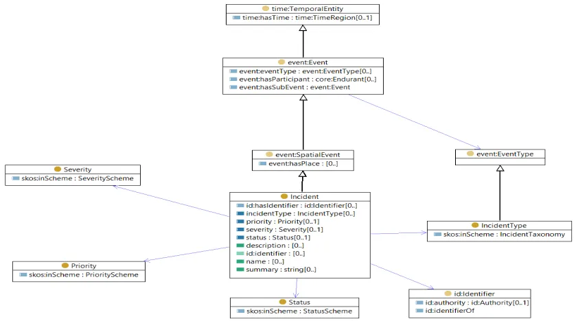
The figure 3 gives an overview of the Incident Ontology Model. Incidents are based on the Event ontology defined in the Core Geospatial Ontologies.
Figure 3: Core incident ontology model
The core Incident Model can be extended using the built-in mechanism in OWL to add specific information used within an application domain or jurisdiction, thus becoming specialized profile of the core Incident model. Existing standards based on syntactic and schematic standards (NIEM, EDXL, NDEX,…) can be integrated in Semantic Incident Management Systems by the use of adapters converting the standard to an RDF
Figure 4: Semantic layer with adapters to the core incident model and derived profiles
There are a number of data-centric standards that are used in existing standards such as NIEM, NDEX, CAP, EDXL, that are applicable to the same approach. We suggest investigating a semantic encoding of these standards for future testbeds. The Abu Dhabi Police LEAPS Models provide the richest model for the LEAPS domain, and we strongly suggest using these models as future baseline for developing a semantic model for
LEAPS.
7.3 Controlled vocabulary in the emergency and disaster management domain
There are a number of controlled vocabularies used in IMS systems (incident types, severities, statuses, priorities, alert types, etc). In the incident ontology, these vocabularies are captured as taxonomies using the Simple Knowledge Organization System (SKOS) ontology. SKOS provides a model for expressing the basic structure and content of concept schemes such as thesauri, classification schemes, subject heading lists, taxonomies, folksonomies, and other similar types of controlled vocabulary. As an
application of the Resource Description Framework (RDF), SKOS allows concepts to be composed and published on the World Wide Web, linked with data on the Web and integrated into other concept schemes using semantic mapping constructs.
In basic SKOS, conceptual resources (concepts) are identified with URIs, labeled with strings in one or more natural languages, documented with various note types,
semantically related to each other in informal hierarchies and association networks, and aggregated into concept schemes.
An advanced SKOS adds the following features:
2) relationships can be specified between concept labels.
The two most important entities in the SKOS ontology are skos:ConceptSchemeand
skos:Concept. In order to distinguish the type of schemes (Incident Type Scheme,
Severity Scheme, etc), we introduce in our Incident ontology subclasses of
ConceptScheme and Concept. Some of the benefits of using SKOS are its multilingual support, its extensibility mechanism and interoperable way to share taxonomies based on Linked Data Standards. It also provides vocabularies for mapping concepts between different taxonomies (skos:exactMatch, skos:narrowerMatch, …), enabling semantic mediation on taxonomies.
These controlled vocabularies are defined outside the Incident ontology, so it could accommodate multiple domains (military, civilian, cyberspace …), be controlled by authoritative standard bodies and sharable with other systems. Typically these controlled vocabularies takes the form of code lists or taxonomies (with broader, narrower terms), which can be both be accommodated by SKOS.
In our Incident ontology, we define the following intrinsic qualities for Incident:
incidentType, severity, priority and status. The values of these properties are typically defined in controlled vocabularies based on the Simple Knowledge Organization System (SKOS) ontology.
In order to support triaging of incidents by systems and end-users, incidents are typically classified using well-known controlled taxonomies defining incident categories. To accommodate these requirements, our ontology leverage the SKOS ontology by introducing a subclass of skos:ConceptnamedIncidentType..
As an example of Incident Type taxonomies, we use the Homeland Security Working Group (HSWG) taxonomies to encode in SKOS
skos:hasTopConcept :MarineIncident ;
8 Emergency and Disaster Management Symbology
8.1 Introduction
A plethora of symbols and symbol schemes exist, but extremely few standardized sets can be found despite the big number of initiatives targeting exactly such a standardized set. Lots of those initiatives date back to the first decade 2000-2009 and have failed to become widely accepted and applied mapping symbol standards.
with the homeland security symbology (found at: www.fgdc.gov/HSWG/index.html) as the basis for the standard model.
A number of symbology mapping initiatives have reported progress on standardizing symbologies within their country or administrative or organizational boundaries, such as the
Canadian Emergency Management Symbology (EMS)
(http://emsymbology.org/EMS/index.html, currently not available);
United Nations Office of Coordination on Humanitarian Affairs (UN-OCHA), which has created a set of 500 freely available humanitarian icons to help relief workers present emergency and crisis-related information quickly and simply (http://reliefweb.int/report/world/world-humanitarian-and-country-icons-2012); Portuguese Disaster Response Map Symbols (DRMS) project, an effort to create a
standard set of symbols that may aid disaster managers and responders to create efficient maps (http://www.rpec-cert.info);
Australasian All-Hazards Symbology, developed by the Intergovernmental Committee on Surveying and Mapping (ICSM) and the Victoria-based company Spatial Vision
(http://www.spatialvision.com.au/index.php/sectors/government/426-australasian-all-hazards-symbology-project.html);
The European INDIGO project Emergency 2D/3D Symbology Reference (http://indigo.diginext.fr/EN/index.html);
World Meteorological Organization (WMO) Intergovernmental Oceanographic Commission efforts on map symbol standardization.
After recognizing the importance of sharing spatial information during emergency situations, the Federal Geographic Data Committee Homeland Security Working Group (FGDC HSWG) was asked to develop a set of standard symbols to be used by emergency personnel during a disaster event. The Emergency and Hazard Management Mapping Standard Point Symbology was submitted to, and accepted by, the American National Standards Institute (ANSI) in 2006 as “ANSI 415-2006 INCITS Homeland Security Map Symbol Standard” (Akella, 2009).
methodology and evolve over time as user and mission requirements call for changes. Thus, compared to external standards, in-house symbologies are more agile and easier to modify and adapt to latest needs.
8.2 Semiology of Maps
“The semiotics of maps, a subfield of cartosemiotics, is the sign-theoretic study of maps“ (Schlichtmann, 2009), with map symbolism being the “core subject of the semiotics of maps”. The other subjects include sign processes (basically the process from production a sign to its reception and the sign employment in cartographic communication), contexts (of sign processes), marginal notes (e.g. legends), and peripheral signification (e.g. allowing to draw further inferences about other context factors). For further information about map symbolism, please be referred to Schlichtmann’s overview of the semiotics of maps, which includes a very interesting discussion about the complexity of map
symbolism (Schlichtmann, 2009).
8.3 Symbol Types
To understand the complexity of building a standard mapping symbol ontology for the disaster and emergency management domain, it is important to discuss the different types of symbols. There is general agreement in literature that symbols can be divided into three categories at least (MacEachren, 1995):
Geometric symbols, sometimes referred to as abstract symbols (e.g. circles, squares, or diamonds), which are often further categorized into point, line, and polygon symbols. Those symbols often need a legend with additional information, as their meaning is not easily conveyed.
Pictoral symbols are also known as image-related or representational symbols, are “similar in appearance to their referent”.
Associative symbols, can be regarded as “emblems” which represent the referent through some analogous relation of parts of other commonly recognized symbols in combination.
In addition to those three categories that are prevalent in literature, there is a fourth, less developed category. This category includes symbols that are associative in nature, but refer to an event that is less commonly known or for which a no common picturization exist, for example a bio-hazard.
8.4 Symbol Comprehension
8.4.1 Theory of Affordances and Other Cognitive Factors
Gibson developed an interactionist view of perception and action that focused on information that is available in the environment (Greeno, 1994). His relational theory of affordances provides interesting insights into what affects our comprehension of symbols. The theory offers an explanation for how people perceive things they see in relation to their earlier frames of reference. According to Gibson, people perceive objects in terms of what they can offer or afford. Hartson in response to Norman defines and uses four complementary types of affordance in the context of interaction design and evaluation: cognitive affordance, physical affordance, sensory affordance, and functional affordance (Hartson, 2003; Norman, 1999). The cognitive affordance is of particular interest in the context of map symbol design and perception. It is a “design feature that helps, aids, supports, facilitates, or enables thinking and/or knowing about something”. Thus, clear and precise symbols could be a cognitive affordance enabling crisis managers to
understand the meaning of the symbol. Functional affordance addresses potential actions taken by map symbol readers in response to the symbol.
Other research has shown that both knowledge and display design go hand in hand to increase understanding of map symbols. According to Langefors Infologic Equation, the understanding of a map symbol does not only depend on the symbol itself, but on the individual’s prior knowledge (Porathe & Sivertun, 2002). This aspect makes the symbol design process and similarly any symbol set transformation or comparison even more complex, as the various levels of knowledge and symbol familiarity need to be considered (Garlandini & Fabrikant, 2009; Hegarty, Canham, & Fabrikant, 2010).
8.4.2 Culture and Gender
Any symbol set should strive for cultural and gender independence in order to mitigate potential misunderstandings. Nevertheless, as recent research has underpinned, culturally neutral symbols are rather elusive (Chan, Han, Ng, & Park, 2009). The importance of this feature heavily depends on the cultural background of the target communities and might be less important in the disaster and emergency management domain.
8.4.3 Sensory Issues and Differences
A number of factors affect symbol interpretation that go beyond the general aspects of affordances as discussed before. Roughly 10% of the global population is expected to be color blind (Hägglund, 2008), which heavily affects color nuances perception and red/green or blue/yellow differentiation. Hägglund cites a number of general
recommendations that can be made:
Black, white, yellow and blue are most readily seen by all, even color blind; Red is typically used for warning but red is dull for the color blind; bright yellow
is preferable to red but may still be mistaken for green by the color blind; Never red and green in the same symbol;
Color differences difficult to perceive when several colors in close proximity in limited spaces
Currently, no symbol set implements all of the recommendations given above, as they limit expressiveness and richness of the symbols if applied all together.
In addition to color blindness related aspects, there are other sensory aspects that may or may not be addressed in symbol sets, such as change blindness, foveal vs. peripheral attention and effects of speed of change and multiple inputs in exposure to map graphics (Ambler & Finklea, 1975; Fish, Goldsberry, & Battersby, 2011; Harrower, 2001). Drawing on the work of Simons and Rensink (2005), American geographers Fish, Goldsberry and Battersby note the importance of the change blindness “phenomenon whereby individuals fail to notice change that occurs in a visual stimulus”. Over a decade of research in this area reveals that human beings consistently overestimate their ability to detect substantial changes in visual graphics used for example in digital maps (Fish et al., 2011).
8.5 FGDC HSWG Symbol Set
The US Federal Geographic Data Committee Homeland Security Working Group (FGDC HSWG) symbology set, standardized by the American National Standards Institute (ANSI), divides symbols into four categories:
Incidents: cause of action or source of disaster;
Natural events: phenomenon created by naturally occurring conditions; Infrastructure: basic facilities, services and installations needed for the
functioning of a community;
Operations: capabilities or resources available during or implemented due to an emergency.
Borders and patterns around these shapes are used to visually classify the symbols into their respective groups. The FGDC HSWG Emergency Management Symbology is designed in black and white. There are concerns regarding the accuracy of the
Symbology library, the limited reference to point symbols, the large amount of detail in the indications of status levels, a very low level of adoption of the FGDC symbology library, and the absence of evaluation with regard to cultural independence and
generalizability. Nevertheless, we used it in this testbed and partially encoded it using the Incident ontology and SKOS.
8.6 Symbology ontology
For this testbed, we limited the symbology to icon representation, as it is a common representation used by E&DM community, but also because the timeframe for this testbed was too short to explore other symbol representation (line, area symbology) and rules of encoding. We used the Homeland Security Working Group Symbology
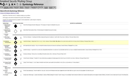
Figure 5: Homeland security symbology for natural events
The core symbol ontology is very simple. The core concept is PointSymbol. It has a
symbolName, an associated font and denotes a concept (Natural Event, Incident concepts, etc..). The denotes property provides the bridge between the symbol representation and the concept it represents. By using semantic mapping between concepts, it is possible to associate multiple symbols to one concept or vice-versa and perform semantic mediation of symbology
The following example represents a symbol for a VolcanicEruption event and its font definition.
Table 2: VolcanicEruption event encoded in ontology :VolcanicEruptionSymbol
rdf:type symbol:PointSymbol ;
symbol:denotes natural-events:VolcanicEruption ; symbol:font <tty:ERS_v2_Natural_Events#0x46> ; symbol:symbolName "Volcanic Eruption" ;
rdfs:label "Volcanic Eruption" . .
<tty:ERS_v2_Natural_Events#0x46> rdf:type symbol:Font ;
symbol:fontCode "0x46” ;
8.7 Datasets investigated
The testbed was mainly focused on developing a core generic model that could be applicable to a number of domains managing incidents. Due to the fact that we didn’t have real datasets to work with, a number of open source datasets were investigated and mapped to the Incident ontology.
911 Seattle Police dataset OpenFEMA summaries
Worldwide Incident Tracking System
The datasets investigated were however not rich enough to perform a relevant scenario that demonstrate the semantic incident management. We would recommend using some real dataset used by LEAPS or E&DM for the next testbed.
8.8 Recommendations
Due to the complexity of symbol sets, the difficulties to map between sets of different background, culture, tradition, and context, and the heterogeneous symbol
comprehension factors, establishing a new model based on the FGDC baseline model cannot be achieved in a single test bed. Instead, we recommend for future test beds to do a direct comparison of two real data sets of neighboring administrative units or of a single administrative unit and the FGDC baseline in close cooperation with the symbol set users and producers. This approach needs to be combined with OGC base ontology
development activities as recommended in the previous chapter.
In addition, we recommend building a set of core domain ontologies for the law enforcement and public safety as well as the emergency and disaster management domain.
As it is important to accommodate jurisdiction-specific and mission-specific profile requirements, it is necessary to identify key points of interoperability in a given service oriented architecture. As an example, the next test bed might investigate Abu Dhabi Police’s (ADP) SoS architecture, defining the required interoperable service APIs and models, as well as the roadmap for achieving a prioritized implementation of these key interfaces and models. The Abu Dhabi Police have submitted a comprehensive set of domain models to OGC for Law Enforcement and Public Safety (LEAPS). These models can be used to derive a set of foundational ontologies that serve as the basis for
interoperability throughout ADP’s system of systems LEAPS domain. The purpose of this task is to formalize and semantically-ground ADP’s LEAPS domain models as ontologies. These ontologies will be built upon OGC’s Geospatial Ontology, and they will define the minimum-essential core set of concepts, properties and relationships for the LEAPS community.
The testbed should demonstrate the feasibility and robustness of the resulting LEAPS Ontology and candidate specifications by testing one or more implementations.
Expected outcome: (1) A set of core ontologies for the LEAPS domain. (2) Prototype applications and services to test and demonstrate profiles of the LEAPS Ontology, employing existing LEAPS data and using GeoSPARQL services to access these data.
Benefits: Demonstrates the benefits of semantically-enabled LEAPS data and services in terms of enhanced cross-domain data integration, search and discovery, and service interoperability. Pinpoints and tests minimum-essential required building blocks for LEAPS interoperability. Accelerates the path to common, coherent LEAPS Linked Data exchange. The roadmap will provide an agile, incremental, prioritized approach to the implementation of the key points of interoperability for LEAPS and E&DM SoS.
9 Hydro Model Interoperability
The Hydro demonstration thread worked on using HY_Feature hydrological model as a mediation model to integrate heterogeneous hydrological models. Two models were tested. They are the National Hydro Network (NHN) of Canada and the National
Hydrography Dataset Plus (NHDPlus or NHD+) of USA. Semantic mappings were tested to achieve hydro data and model conversion and integration among HY_Feature, NHN, and NHD+. The test on semantic mappings focused on flow path linear feature. The ontologies for all three models and their conversion models were built using OWL with Protégé editor. The knowledge store is published through a generic SPARQL engine. The examples were documented in the ER in the five use cases - (1) mapping hydrographic features from NHD+ to HY_Feature, (2) mapping hydrographic features from NHN to HY_Feature, (3) hydrographic mapping between NHD+ and NHN, (4) finding upstream service (flow path feature tracing and model conversion), and (5) heterogeneous
hydrological model integration (across borders of US and Canada). The Hydro engineering report is available at
Bibliography
Akella, M. K. (2009). First Responders and Crisis Map Symbols: Clarifying
Communication. Cartography and Geographic Information Science, 36(1), 19–28. Ambler, B. A., & Finklea, D. L. (1975). The influence of selective attention in peripheral
and foveal vision. Perception & Psychophysics, 19(6), 518–524.
Bianchetti, R. A., Wallgrün, J. O., Yang, J., Blanford, J., Robinson, A. C., & Klippel, A. (2012). Free Classification of Canadian and American Emergency Management Map Symbol Standards. The Cartographic Journal, 49(4), 350–360. Retrieved from http://scholar.google.com/scholar?hl=en&btnG=Search&q=intitle:Free+Classificatio n+of+Canadian+and+American+Emergency+Management+Map+Symbol+Standard s#0
Chan, A. H. S., Han, S. H., Ng, A. W. Y., & Park, W. (2009). Hong Kong Chinese and Korean comprehension of American security safety symbols. International Journal of Industrial Ergonomics, 39(5), 835–850.
doi:http://dx.doi.org/10.1016/j.ergon.2009.02.009
Fish, C., Goldsberry, K., & Battersby, S. (2011). Change Blindness in Animated Choropleth Maps: An Empirical Study. Cartography and Geographic …, 38(4), 350–362.
Garlandini, S., & Fabrikant, S. (2009). Evaluating the effectiveness and efficiency of visual variables for geographic information visualization. Spatial Information Theory, 195–211.
Greeno, J. (1994). Gibson’s affordances. Psychological Review, 101(2), 336–342. Gruber, T. (1993). A Translation Approach to Portable Ontology Specifications.
Knowledge Acquisition, 5(April 1993), 199–220. Retrieved from http://www.sciencedirect.com/science/article/pii/S1042814383710083
Hägglund, C. (2008). Design of a driver-vehicle interface for local surrounding world information in intersections surrounding world information in intersections. Uppsala University.
Harrower, M. (2001). Visualizing Change : Using Cartographic Animation to Explore Remotely-Sensed Data. Cartographic Perspectives, Spring 200(39), 30–42. Hartson, R. (2003). Cognitive, physical, sensory, and functional affordances in