ERAS OF WEB MAPPING DEVELOPMENTS: PAST, PRESENT AND FUTURE
Bert Veenendaal
Department of Spatial Sciences, Curtin University, GPO Box U1987, Perth, Australia – [email protected]
Commission IV, WG IV/5
KEY WORDS: Web mapping, Web GIS, Web development, Geoweb, Online mapping, Map use, Mapping generations
ABSTRACT:
Developments in web mapping and web based geographic information systems (GIS) have evolved rapidly over the past two decades. What began as online map images available to a small group of geospatial experts and professionals has developed to a comprehensive and interactive web map based on integrated information from multiple sources and manipulated by masses of users globally. This paper introduces a framework that outlines the eras of web mapping and significant developments among those eras. From this framework, some of the influences and trends can be determined, particularly those in relation to the development of technologies and their relation to the growth in the number and diversity of users and applications that utilise web mapping and geospatial information online.
1. INTRODUCTION
1.1 General Overview
Since the beginnings of the Web and the first World Wide Web conference in 1994, the interactions among and between information and people have evolved dramatically. The Web is not simply a developing technology for content, but involves people who generate content, communicate and interact in collaborative environments (Hall & Tiropanis, 2012). New user needs evolve and technology needs to develop to meet these needs, in turn generating more needs and an iterative cycle of technology development and user/application growth and expansion.
Geospatial data and mapping have been instrumental in fuelling the use of the Web to support people and information interactions (Li et. al., 2011). Of course, the Web has also played a foundational role in the provision of online mapping and web GIS.
Understanding the developments in web mapping and the influence on technology, information and users is important for a number of reasons. Firstly, it provides a means of understanding the multi-faceted nature of web mapping and GIS developments. Secondly, it provides a basis to be able to identify trends and relationships among the various web mapping and related developments to understand the influences and drivers. Finally, it provides a means to identify possible future opportunities, developments and directions.
1.2 Aim and scope
This paper reviews and explores the development of web mapping and GIS and how it has been characterised. A framework for identifying the significant developments and eras in web mapping is developed and detailed. The progression of developments along these web mapping eras are then highlighted with a view towards identifying the future directions and significance of web mapping and GIS.
Because of the fast moving nature of web, mapping and GIS technologies, it is acknowledged that such a framework is a work in progress. As the developments and usage of web
mapping and GIS continue to evolve and propagate, new influences and trends may become apparent. Further, the description of technologies and influences described in this paper are not exhaustive, but rather are the main significant ones and indicative of the important developments.
2. BACKGROUND AND DEVELOPMENTS
2.1 Characterisations of web mapping developments
A number of attempts have been made to capture web mapping developments. This is mostly done with regards to technology improvements at either a broad generic level or specifically linking to prominent technology initiatives.
In terms of its development, the web generally has been identified by various authors through the use of four generations termed Web 1.0 to Web 4.0 (and beyond) (Fu & Sun, 2011; Choudhury, 2014). These are identified in Table 1. Web 1.0 defined the first era of read webs, focussed on retrieving information. They used the basic HTTP and HTML technologies to disseminate online linked information according to the vision of Berners-Lee (1998). Web 2.0 is a read-write web where users can interact collaboratively for content creation, modification and sharing (O’Reilly, 2005). Web 3.0 is also known as the semantic web and focusses on enabling machine understanding of semantically structured data that provides users with more meaning and relevant information (Berners-Lee et. al., 2001; Palmer, 2001). Choudbury (2014) describes Web 4.0 as the ultra-intelligent agent that makes decisions as powerful as the brain to enable collaboration among communities. Although there are various attempts at describing Web 5.0, it remains essentially undefined and speculative.
In one of the earliest textbooks on the Internet and GIS, Peng & Tsou (2003) describe the web developments for GIS from a technology perspective (Table 1). They identify static map publishing with the initial use of HTML and static images for maps. Static web mapping expands the developments with HTML Forms and CGI. Then follows interactive web mapping using Dynamic HTML, scripts, plug-ins, ActiveX, Java applets and servlets, where the user interaction exists but is limited.
Finally, the distributed GIServices period enhances interactivity by allowing components on clients to communicate with components on servers using technologies such as Java Applets, Corba .Net and XML (Peng & Tsou, 2003).
Table 1: Various characterisations of web mapping developments in the literature
Tsou (2005) approached the evolving world of web mapping by highlighting the major technology changes. Although only focussing on the year 2005, he identified three significant developments (Table 1). Firstly, GIS awareness grew significantly among the general community fuelled by the release of free satellite imagery on the one hand, and by occurrence of major disaster events on the other hand. Events in 2005 such as the South Asia Tsunami and Hurricane Katrina alerted the global community to the importance of using mapping and GIS technology to manage and respond to such events.
A second significant development in 2005 highlighted by Tsou (2005) was two new internet technologies, namely AJAX and image tiling, both focussed at increasing the response times of web maps for users. These technologies formed the foundation for the development of virtual globes and online mapping services, identified as the third major change by Tsou (2005). Included in this change were also the wireless location based services resulting in mobile access to GIS and mapping technologies.
Plewe (2007) identifies four generations of web maps based on the types of technologies underpinning the map (Table 1). The first generation maps are static maps such as those pioneered by the Xerox PARC map server (Xerox, 1993). They are maps embedded in HTML files with simple click access via hyperlinks. The next generation comprises dynamic HTML maps using Java and ActiveX with the map interfaces starting to appear similar to GIS interfaces at that time. However, functionality was limited to map browsing and simple queries.
The third generation web mapping was spurred on by the
development of the Asynchronous Javascript and XML (AJAX) technology which improved response times. This made way for open service application programming interfaces (APIs) which could be accessed and combined with user contributed data in the generation of mashups.
Finally, the fourth generation was focussed on the virtual earth globes such as Google Earth and Microsoft Bing, which provide users with a more realistic and immersive experience with a three dimensional Earth. The advent of these first public web
services with global coverage of digital imagery opened up the geospatial world of mapping to the public community worldwide via the Internet. The ability to generate maps expanded well beyond the small group of web developers and mapping experts. As Plewe (2007) points out, the result is that knowledge and interest in places of experience become the realm of the average citizen, no matter where in the world they are located.
Following on from Plewe’s (2007) four generations of web mapping, Tsou (2011) described a fifth generation built on cloud computing, rich internet applications (RIA) and crowdsourcing. Rather than focussing on obtaining sufficient hardware resources and downloading desktop software, users can access cloud computing resources and services, which now include, for example, Amazon’s cloud storage and web services, Microsoft Azure cloud and Esri’s ArcGIS Online. RIA refers to the web programming environment that provides a friendly user interface and access to powerful widgets and tools (eg. Java Scripts and Adobe FLEX).
Crowdsourcing, also referred to as volunteered geographic information (VGI), is where volunteers can contribute and share their information and knowledge about maps and location via web maps and location-based tools. In this way, the user community are not only consumers of geospatial information and maps, but also producers that contribute to the shared knowledge of our world.
2.2 User and usage focus of web mapping
The generations of web mapping, as identified by the authors referred to in Section 2.1, all highlight technology developments to support shared data online. However, there is also a recognition among these authors that there is an increasing focus on users, especially in later technological developments involving virtual globes, crowd-sourcing and RIAs. The expanding global user community means not only that they can retrieve and share information, but more importantly, they have a role to contribute and share their own knowledge to add the vast web based geospatial and mapping resources base that exists.
The development and influence of the geospatial web goes well beyond only individuals. Seo and Lee (2016) focus on the influence of Web 2.0 technology on organisations. Organisations must adopt an appropriate vision with adequate support to adequately embrace and utilise Web 2.0 to create value. There is a strong emphasis on user culture that must grow alongside technology developments in order to reap the benefits and take advantage of new opportunities. Seo and Lee (2016) compared and analysed a number of large organisations in terms of their technological and organisational readiness to adopt Web 2.0. In general, where the organisation has developed a culture and initiatives involving interaction and democracy, in essence the principles underlying Web 2.0, they have obtained better value and performance in adopting Web 2.0 technologies.
In fact, the focus on web mapping developments goes even further than information and people. It goes to the heart of people interactions and engagements at a global level. Hall & Tiropanis (2012) identify stages of Web evolution based on the primary focus of the developments (see Table 1). Firstly, the web appeared as the Web of documents, then was transformed into a Web of people and now is developing as the Web of data
and social networks. So the latter transition of the Web is focussed on a stronger link involving people and data, namely the people to people interactions around information and knowledge. So in the geospatial context, this includes community mapping, location-based and mobile activities, dynamic processes and interactions in geographic context, etc..
Of course, these interactions and collaborations are very much supported by the technology developments. Web mapping technology supports ability of people and information to interact. For example, Steiniger and Hunter (2013) concluded that the development of technologies such as CSS, AJAX and HTML 5 enabled applications on web browsers to have the same functionality as those on desktop computers. This is important when people move from a desktop environment into the internet and cloud environment. They require access to similar functionality in a recognised and friendly environment tailored to their purpose of use. The web GIS environments have similar functionality and interfaces to the desktop GIS environments, and therefore supports and encourages the uptake of the online environment. Through their exposure on the web, many of these GIS and mapping functionalities are becoming commonplace among the global community users among which geospatial information and maps are just another information resource.
With enhanced functionality comes also the need to ensure that diverse users in the global community with a range of skills and experiences are able to utilize these functions. Kong et. al. (2015) were able to identify a range of web GIS functionalities used for common geospatial information searches in academic libraries. They did a usability study across six applications and identified 8 core web GIS functions. They conclude that web mapping development needs to strongly address the experience levels and expectations of public users in order to promote and enhance interactions and experiences with geospatial information.
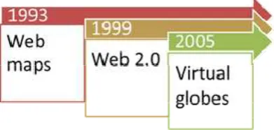
In the context of web map use, Veenendaal (2015) identified three relevant and influential web mapping developments, namely, basic online maps, Web 2.0 interactive mapping and virtual globes (Figure 1). The advent of online maps enabled users to retrieve and share mapping data and information. The Web 2.0 developments enabled users to not only use the map, but contribute to the map and the knowledge it was communicating. The virtual globe developments enhanced that user interaction by growing the user base and generating a much more immersive environment to stimulate user engagement and collaboration.
Figure 1: Web mapping developments supporting web map use (Source: Veenendaal, 2015)
Closely related to web map usability is web map design which has also had to go through several stages of evolution. Tsou (2011) identifies two waves of the web map design revolution. The first is the virtual globes development beginning with the release of Google Earth in 2005 (Google, 2005). The improved performance of web maps was aligned to an improved user interface that was more user-centered and dynamic in the user’s interaction with the map. The second wave was the development of mobile mapping on smart phones and mobile devices that incorporated GPS location tracking together with user-friendly touch screens. The design of maps now had to accommodate the smaller screen displays, touch screen events, and filtering of only relevant and useful map content within the subsequent proliferation of web map apps.
3. WEB MAPPING ERAS
3.1 Unfolding of web mapping eras
The developments in web mapping are a continuous blend of improvements in technologies, increase in data and information, growth in users and usage, and interaction among all of these. Attempts to track and understand these developments, let alone trying to predict the future directions of research and developments is very difficult. We have tried to assemble the web mapping eras so that significant developments across this blend of interactions are identified. The significant developments have been chosen on the basis that they have had a significant influence on further developments, whether they be technologies, information, usage or interaction.
The web mapping eras chosen were based on an integration and extension of the developments and eras identified by previous authors (refer to Table 1). Whereas previous authors identified between 3 to 5 distinctive eras or developments, we have reassembled them into eight eras, where the last era has also been extended to include very recent and future developments.
Eight web mapping eras were identified and placed in a timeline to mark significant developments. Figure 2 names and provides a summary of each era, a short list of the significant developments within that era, and a star indicating the approximate commencement of that era. No “end” of an era is defined as many of these developments have either continued or been embedded in subsequent eras.
Figure 2: Framework of web mapping eras
The static mapping era refers to essentially the beginning of Web 1.0 in the early 1990s where the phenomena of a web map was realised through an HTML image and hyperlinks. Users
had some simple choices to select specified parameters regarding the content, options and layout of the map. This era is equivalent to Plewe’s (2007) first generation web maps. Being able to store and retrieve a (traditional) map on the web was a major step in being able to share maps with multiple users beyond the paper-based map.
Once multiple users started to share a web map, it was obvious that the digital technology could be used to customise the map in some dynamic way to cater for the various users requirements. Dynamic maps using DHTML, Common Gateway Interface (CGI), Java and ActiveX technologies enabled users to retrieve maps that were dynamically created and constructed on the server according to user preferences and choices.
Now that various map construction functions were occurring at different servers across the Internet, there needed to be a way to “package” the functions for users. In the services web mapping era, component-based technologies such as Java Applets, CORBA, .NET, etc. were used to create replaceable components with well-defined interfaces to facilitate a flexible and interoperable environment. These components were assembled as web services within a service-oriented architecture (SOA) that could be published, invoked and discovered on the web.
The interactive web mapping era equates with Tsou’s (2005) second significant development and Plewe’s (2007) third generation web maps. The emerging image tiling technology combined with AJAX technology allowed online maps to be delivered to a user in a continuous and responsive manner. While the downloading of image tiles occurs in the background in an asynchronous fashion, the user experiences no wait time while viewing a continuously refreshing and emerging image (Tsou, 2005). This increased the focus on the user experience and paved the way for the next web mapping era. It also marked the start of the Web 2.0 developments and opened the way for more users to participate in both mapping retrieval and data creation activities.
Arguably one of the most significant events, the digital globe web mapping era, has opened up the power of mapping to the global community. Digital globes have exploited the benefits of the emerging technologies to provide an environment in which the user could experience an immersive experience in Earth imagery, not only in 2D but also in a 3D environment. The emergence of Google Earth, Microsoft Virtual Earth (now BING), NASA World Wind and a host of additional virtual earth platforms, have exposed maps and digital earth imagery to the common every-day citizen. The digital globe interfaces and realistic earth imagery brought the world to the desktop like no other previous mapping application ever did. The user base suddenly expanded exponentially from specialist geospatial developers and professionals to the global community, essentially anyone who has an internet connection (which is now almost everyone in the world!).
The next wave of web mapping followed closely on the heels of digital globes by providing web maps on mobile devices. Now, users could interact with maps at whatever place and time they chose. With the development of GPS and location integrated into mobile phones and devices, location based services (LBS) developed to provide users with geospatial and mapping information directly linked to their location and locality. At the same time, the ability to provide content linked to location
enhanced the capacity for global users to contribute and share their own local data and knowledge. Volunteered geographic information (VGI) became integrated into many mobile (and desktop) apps so that users became both consumers and producers of information. This fed into the generation of communities linking to and utilising a host of related technologies including mashups, blogs, wikis, social networking and shared atlas/mapping portals.
The cloud web mapping era focusses on the availability and scalability of increasing masses of information, with the cloud providing a solution. Now storage, software, services and infrastructure can be provided on the web in the cloud, providing a measure of reliability, stability and scalability for information, applications and users. This era is part of Tsou’s (2011) fifth generation web mapping technology providing resource pooling, virtualised applications and a shared platform from which mapping applications and databases can be built, integrated and shared on the web. Cloud computing supports the expansion of the digital earth technologies as well as complex geospatial applications (Yang et al., 2011). It has also provided a platform to manage and manipulate Big Data which is a characteristic of the growing volumes of geospatial data being collected through sensors and mobile devices (Lee & Kang, 2015). Emerging platforms, like the open source Hadoop, provide a distributed and parallel computing environment to perform geospatial big data analytics.
The intelligent web mapping era embraces semantic
technologies and smart devices that provide context and customisation to the information delivered to users and applications. This era is still presently in its early stages, with the goal to provide only relevant information to users in the appropriate context: geographic, temporal, attributed, semantic, historical, etc. For example, Devaraju et al. (2014) explore how to derive understanding and knowledge of geospatial events from sensor observation data. This era also encompasses the semantic web and Web 3.0 developments (refer to Section 2.1). Although still evolving and being defined, this era tries to encapsulate the fact that what information is being provided to users/applications must be done in a smarter way, matching the information scope to the user needs. Being able to filter information in an intelligent fashion leads the creation and usage of better knowledge and decision-making ability.
3.2 Discussion
Each of the web mapping eras identified have a significant technological development that primarily defines that era. The technology then influences the accessibility to data by providing a shared platform (static, cloud), improving the response times to data requests (dynamic, components, interactive), providing a richer interface for data access (digital globe, mobile, intelligent) and enabling data generation (interactive, digital globe, mobile, intelligent).
Not only do the web mapping eras define technology and access to data, but they also have a strong focus on users and their ability to use geospatial and mapping information. The static era was significant for giving multiple users access to an online shared map. Users then were able to interact with the map for the purposes of customising it, selecting the information to be visualised, and being able to navigate through a 3D landscape with adequate performance in terms of response times (dynamic, interactive, digital globe). The mobile era provides users with the ability to interact with mapping information from
personalised and mobile devices, enhancing convenience in time and place.
However, the most significant impact of web mapping as seen through the eras is the dissemination of the web map to a huge proliferation of users. Whereas the exposure to web mapping was limited in the early eras to a relatively small group of expert users and developers, the digital globe era witnessed the explosion of web mapping interaction to the average citizen and global community, in fact, everyone in the world! Essentially the user base expanded from the order of thousands to essentially billions in a very short time. That exposure was very significant as it opened up geospatial data and web maps to a very diverse user base and a whole range of new applications. Suddenly, geospatial mapping extended beyond the grasp of a small group of technical geospatial experts to a global community of users including the general public. Further, it has expanded beyond the traditional realm of the likes of land managers, natural resources management and infrastructure developers, to users and applications of health, business, education, finance, economics, travel, tourism, etc.
This proliferation of users and applications has implications for web mapping and GIS developments. Firstly, it creates a diverse range of usage and hence also a broader range of diverse datasets that must be accommodated and integrated within a web environment. Secondly, interaction with that information generates greater opportunities for users that go beyond their traditional usage and scope of information.
Hence, as the range of web mapping and GIS usage increases, expectations rise, and new requirements are formed, paving the way for further technology development to meet those needs. Users realise the greater potential of knowledge gained by having access to a web map that integrates information in time and space for a given geographic location; however, now they want only the relevant information in the context of their queries without having to navigate extensively through a web map. For example, a land developer may be exploring the development potential of a particular block of land, and is seeking relevant information that indicates the various infrastructures and services running through that land, as well as proximity to service access points.
To deliver that “relevant information”, there must be a discovery and integration of all necessary information resources, and appropriate geo-processing services to manipulate and filter the data to suit the user profile and context. To use the example, the appropriate data involving roads, drainage, sewerage, water, power, specific covenants on the land, protected lands and easements, must be extracted, linked, integrated, refined and presented to the land developer in the context of appropriate terminology, symbology, etc. This may involve building ontologies for the different data themes and semantically linking them together so that queries and results can be contextualised to the type of user. This is an aspect of current developments in the eighth web mapping era of intelligent (refer Figure 2).
4. SUMMARY AND CONCLUSIONS
A framework identifying eight eras of web mapping developments has been identified. These eras encapsulate the main developments that have influenced the growth of technology, the expansion of users and the increase in geospatial data and mapping usage.
Although the eras especially highlight the technological developments, the effect on users has been significant. The growth in the numbers of users and their usage of web maps and geospatial information has increased prolifically. Further technological developments will need to address the expanding usage and requirements of users. As usage increases, users will recognise greater opportunities, and increasing requirements and needs will dictate new developments in technology and data handling.
Users continually want better information, focussed to their needs and customised to their level of knowledge and skills. This means that web mapping and GIS systems and services will need to be more intelligent, efficient and focussed to support users and applications at a knowledge level. That also means there will need to be a greater level of semantics defined and representation of knowledge so that automated or semi-automated decisions can be made about how the information is to be presented to the user in the user context.
The intelligent web mapping era is still an era in progress and yet early in development. This era is itself still being defined as higher levels of knowledge and ontologies are constructed for data and information, so that they can be linked and queried in the context of users, and the environments and workflows in which they operate (Veenendaal et al., 2016). The focus on web mapping certainly has changed from a technology/data focus to meeting the needs of diverse users at a higher level of understanding and knowledge that does not assume technology and data expertise.
Future developments around knowledge building and user context within the current intelligent web mapping era will add more clarity to what future intelligent web mapping and web GIS developments will be, and this in turn will pave the way for defining and detailing future web mapping eras.
REFERENCES
Berners-Lee, Tim. 1998. The World Wide Web: A very short personal history. http://www.w3.org/People/Berners-Lee/ShortHistory.html (12 November 2015).
Berners-Lee, T., J. Hendler, and O. Lassila. 2001. The Semantic Web. Scientific American, May, pp. 34–43, http://www-sop.inria.fr/acacia/cours/essi2006/Scientific%20American_%20 Feature%20Article_%20The%20Semantic%20Web_%20May% 202001.pdf (21 Nov 2015).
Fu, P. & J. Sun. 2011. Web GIS: Principles and applications, ESRI Press, Redlands, California.
Google. 2005. Google Launches Free 3D Mapping and Search
Product. Google Inc.,
http://googlepress.blogspot.com.au/2005/06/google-launches-free-3d-mapping-and_28.html (25 May 2015).
Haklay, M., A. Singleton & C. Parker. 2008. Web Mapping 2.0: The Neogeography of the GeoWeb. Geography Compass, 2/6, pp 2011-2039, http://week9neogeog.pbworks.com/w/page/f/ Web+Mapping+2.0+The+Neogeography+of+the+GeoWeb.pdf (23 Feb 2012).
Hall, Wendy & Thanassis Tiropanis. 2012. Web evolution and Web Science. Computer Networks, Elsevier, 56, pp. 3859-3865.
Kong, Ningning, Tao Zhang & Ilana Stonebraker. 2015. Evaluation of web GIS functionality in academic libraries. Applied Geography, 60, pp. 288-293.
Lee, J.-G. & M. Kang. 2015. Geospatial Big Data: Challenges and Opportunities. Big Data Research, 2 (2), pp. 74-81.
Li, S, B Veenendaal & S Dragićević. 2011. Advances, challenges and future directions in web-based GIS mapping services. In Li, S, Dragićević, S and Veenendaal B (2011) Advances in Web-based GIS, Mapping Services and Applications, Taylor & Francis Group, London, ISBN 978-0-415-80483-7.
O’Reilly, T. 2005. What Is Web 2.0: Design patterns and business models for the next generation of software. O’Reilly Media, http://oreilly.com/web2/archive/what-is-web-20 (25 May 2015).
Palmer, Sean B. 2001. The Semantic Web: An Introduction. http://infomesh.net/2001/swintro (12 Nov 2015).
Peng, Z. & M. Tsou. 2003. Internet GIS: Distributed Geographic Information Services for the Internet and Wireless Networks. New Jersey: John Wiley & Sons, Inc.
Plewe, Brandon. 2007. Web cartography in the United States. Cartography and Geographic Information Science, 34:2, April.
Seo, DongBack & Jung Lee. 2016. Web_2.0 and five years since: How the combination of technological and organizational initiatives influences an organization’s long-term Web_2.0 performance. Telematics and Informatics, 33, pp. 232-246.
Steiniger, Stefan and Andrew J.S. Hunter. 2013. The 2012 free and open source GIS software map – A guide to facilitate research, development, and adoption. Computers Environment and Urban Systems, 39, pp. 136-150.
Tsou, Ming-Tsiang. 2005. Recent developments in Internet GIS. GISdevelopment.net, http://www.gisdevelopment.net/ technology/gis/techgis_002pf.htm (12 Nov 2015).
Tsou, Ming-Tsiang. 2011. Revisiting Web Cartography in the United States: The Rise of User-Centered Design. Cartography and Geographic Information Science, 38:3, July, pp. 250-257,
http://icaci.org/files/documents/national_reports/2007-2011/USA.pdf (12 Nov 2015).
Veenendaal, Bert. 2015. Developing a map use model for web mapping and GIS. The International Archives of the Photogrammetry, Remote Sensing and Spatial Information Sciences, XL-4/W7, 2015, 4th ISPRS International Workshop on Web Mapping and Geoprocessing Services, 01 – 03 July 2015, Sardinia, Italy, http://www.int-arch-photogramm-remote- sens-spatial-inf-sci.net/XL-4-W7/31/2015/isprsarchives-XL-4-W7-31-2015.pdf (27 Nov 2015).
Veenendaal, Bert, Maria Antonia Brovelli & Lixin Wu. 2016. Cloud/web mapping and geoprocessing services – Intelligently linking geoinformation. ISPRS Journal of Photogrammetry and Remote Sensing, editorial, Elsevier, Volume 114, April 2016, pp. 243–244, www.sciencedirect.com.dbgw.lis.curtin.edu.au/ science/article/pii/S0924271616000629 (15 Apr 2016).
Xerox. 1993. Xerox PARC Map Viewer. Palo Alto Research Center, Image accessed online: http://www.inwap.com/inwap/ chez/parc-map.html (12 May 2015).
Yang, Chaowei, Michael Goodchild, Qunying Huang, Doug Nebert, Robert Raskin, Yan Xu, Myra Bambacus & Daniel Fay. 2011. Spatial cloud computing: how can the geospatial sciences
use and help shape cloud computing? International Journal of Digital Earth, 4:4, 305-329,.
ACKNOWLEDGEMENTS
The author would like to acknowledge those who have influenced the thinking and ideas behind this framework, including international colleagues as well as the students at Curtin University who have used the framework as a tool to learn, understand and appreciate web mapping and web GIS. The author would also like to acknowledge the constructive and insightful feedback received from the independent reviewers that served to enhance this paper.