FOREST LAND USE CHANGE ACROSS
THREE-TIME PERIODS
1By:
Rahmawaty1., T.R. Villanueva2; M.G. Carandang2; R.L. Lapitan2; N.C. Bantayan2; A.J. Alcantara3
1 Department of Forestry, Faculty of Agriculture, Sumatera Utara University, Jl. Tri dharma Ujung No. 1 Kampus USU, Medan, 20155, North Sumatra, Indonesia
2 Institute of Renewable and Natural Resources, College of Forestry and Natural Resources, University of the Philippines Los Banos, College, Laguna 4031 Philippines
3 School of Environmental Science and Management, University of the Philippines Los Banos, College, Laguna 4031 Philippines
ABSTRACT
Sustainable land use especially forest is an issue concerning both the government and land users in preserving the land resources for the benefit of present and future generations. This study generally aimed to assess forest land use changes across three-time periods, namely: 1990, 2001, and 2006. The study was conducted in the Besitang Watershed, Indonesia through the use of GIS and transition matrix. Remarkable forest land use change occurred for the past 11-year period (1990-2001) indicates that mangrove forest and primary forest areas have a high rate of forest disturbance in the forest area. Between 2001-2006 (past five-year period), a high rate of forest disturbance occurred in the primary forest. Forest land use changes across three-time periods showed that a high rate of forest disturbance occurred in the primary forest, followed by mangrove forest. However, there was an increase in the secondary forest in this area. Most of these changes can be traced to poor implementation of land use policies as well as to the demand and pressures from growing population in the area.
Keywords: Forest, land use change, GIS.
Corresponding author:
Email addresses: [email protected]/ [email protected]
Phone/fax. +62618364143/+62618201920 Cell phone: +6287885302198/+6281380540870
1 Paper presented at the “USU International Science and Technology Exhibition and Seminar (USU
INTRODUCTION
Background of the Study
Besitang Watershed that is located in SWS Wampu-Besitang, is one of Priority II watersheds in Indonesia (Ministry of Forestry, 2005). Besitang Watershed has borders in Nanggroe Aceh Darussalam (NAD) Province. Moreover, there is Gunung Leuser National Park (TNGL) as a protected area in that area. Land conversion to oil palm plantation and fish pond in the mangrove forests by the surrounding community is problem in that area. According to Anderle et al. (1994), rising population pressure coupled with mounting competition by different types of land users is a major challenge faced by land use planners and policy-makers. Rational and sustainable land use is an issue for both the government and land users in preserving the land resources for the benefit of present and future generations. Land use decisions are based on comprehensive and quantified assessment of potential and development possibilities of the land resources taking into account the biophysical, environmental and socio-economic factors as well as the space and time dimensions of sustained land use (Antoine et al., 1997).
Changes in the use of land occurring at various spatial levels and periods can have either beneficial or detrimental effects. The latter is a concern of decision-makers because of their effects on the population and the environment. The goal of managing land use and its changes is to develop the land resources in ways that capitalize on the local potential and suitability, avoid negative impacts and respond to present and future societal demand within the limits of the carrying capacity of the natural environment (FAO, 1995).
Based on the Besitang Watershed’s condition, some thoughts on good steps or
actions are needed to overcome land use problems. Rehabilitation of watersheds is also needed so that it can support and enhance other environment functions. At present, researches on forest land use change which are crucial for successful and sustainable watershed management have not been conducted in the area.
Objectives of the Study
MATERIALS AND METHODS
Data Collection
This study used secondary data that were gathered from different offices:
1). Langkat administrative map (2003) was obtained from the combination earth feature of Indonesia map/Peta Rupa Bumi Indonesia (RBI) or what is called as basic map with precision scale 1:50,000.
2). Watershed boundary map was obtained from Watershed Management Bureau (Balai Pengelolaan DAS Wampu Sei Ular), Ministry of Forestry (2005) with scale 1:250,000.
3). Land use maps (1990, 2001, and 2006) were obtained from Landsat image interpretation by BAKOSURTANAL and the Ministry of Forestry.
4). The land use/forest classification map based on Decrees of Ministry of Forestry Number 44 (2005) was obtained from the Ministry of Forestry (2006).
Forest Land Use Change Method
All data (thematic layers) that were gathered from different offices were projected on Universal Transverse Mercator (UTM) Zone 47 N before determined land use/land cover change. Then, Land use/land cover change in the area was determined by overlaying maps of different periods, using ArcView GIS and ArcGIS (multi-thematic intersect operation). The data gathered were encoded in the computer using the spreadsheet program (Microsoft Office Excel) and output tables were exported as data based file (dbf) table.
RESULTS AND DISCUSSION
Forest Land Use Change
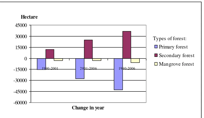
The existing digital GIS files of land use 1990 and land use 2001 maps from BAKOSURTANAL and land use 2006 maps from Ministry of Forestry were used. The distribution of land use area across three-time periods (1990-2001-2006) is shown in Figure 1. The change in forest land use was determined by overlaying land use maps of 1990-2001, 2001-2006, and 1990-2006 using ArcView GIS and ArcGIS. Figure 1 shows that land use change in Besitang Watershed for the past 11-year period (1990-2001) indicates that mangrove forest and primary forest areas have a high rate of forest disturbance in the forest area. It accounted for 26% or 2,976 ha drop for mangrove forest and 34% or 15,239 ha decrease for primary forest, while there was a steady rise between 1990 and 2001, 100% or 11,911 ha secondary forest (Figure 1). For the other kinds of land uses, such as in plantation, there is increase of 170% or 6,512 ha and 100% or 429 ha in unvegetated. In dry land agriculture, there is marked increased of 11% or 3,799 ha, and in the rice field, a reduction of 59% or 1,285 ha occurred. A decline of 159 ha for swamp and 3,869 ha for bush or 100% in both swamp and bush are also noted.
Between 2001-2006 (past five-year period), a high rate of forest disturbance occurred in the primary forest. The primary forest decreased by 95% or 2,7594 ha, the mangrove forest declined by 36% or 2,987 ha, while there was a steady rise between 1990 and 2001, 207% or 24,660 ha secondary forest (Figure 2).
0 5000 10000 15000 20000 25000 30000 35000 40000 45000
Hectare
1990 2001 2006 Year
Types of land use:
Bush
Dry land agriculture
Primary forest
Secondary forest
Mangrove forest
Plantation
Rice field
Swamp
Unvegetated
Fish pond
Water
Figure 1. Distribution of land use area across three-time periods
Types of forest:
-60000 -45000 -30000 -15000 0 15000 30000 45000
1990-2001 2001-2006 1990-2006
Change in year Hectare
Primary forest
Secondary forest
Mangrove forest
Processes of Forest Land Use Transitions
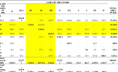
Transition matrices of forest land use change for 1990-2001 and 2001-2006 are shown in Tables 1, 2 and 3 respectively. In 1990, the condition of forest was still very good, because in this time there was no secondary forest. It means that the forest condition was not yet disturbed. Between 1990-2001 (past 11-year period), about 11,076 ha or 25% of the total primary forest were converted to secondary forest, followed by conversion to dry land agriculture of 2,675 ha or 6%. Primary forests converted to plantation was 887 ha or 2%, and the area converted to unvegetated lands is 396 ha or 0.9%. Mangrove forest was converted to dry land agriculture by 3,139 ha or 28% of total mangrove forest, followed by conversion to plantation of 453 ha or 0.04% and converted to unvegetated 24 ha or 0.2%.
During the period 2001-2006, the high rate of forest disturbance was from conversion of 26,423 ha into secondary forest (91%) of total primary forest, followed by conversion of 1,171 ha primary forest into bush (4%). This study is in agreement with Wicke et al. (2008). Mangrove forest area was transformed into fish pond by 2,149 ha or 26% of total mangrove forest, followed by conversion of 706 ha or 9% into dry land agriculture, conversion of 397 ha or 5% into bush, conversion of 294 ha or 4% into unvegetated, conversion of 263 ha or 4% into swamp, conversion of 220 ha or 3% into rice field, and conversion of 82 ha or 1% into plantation.
Forest land use areas which did not change for 1990 to 2001, 2001 to 2006, and 1990 to 2006, namely: the original area of primary forest and mangrove forest, 66% and 60%, respectively did not change in the 1990-2001 period. In the 2001-2006 periods, only 5%, 48% and 79% of primary forest, mangrove forest and secondary forest did not change, respectively.
Besitang Watershed has borders in Nanggroe Aceh Darussalam (NAD) Province, as a result this area has become a new place for refugees from NAD.
Table 1. Transition matrix of land use change for 1990-2001
LAND
Note:: B=Bush, DLA=Dry land agriculture, PF= Primary forest, SF=Secondary forest, MF= Mangrove forest, P= Plantation, WA= Wetland agriculture (rice field) , S=Swamp, U=Unvegetated, FP= Fish pond, W= Water
Table 2. Transition matrix of land use change for 2001-2006
LAND
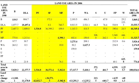
Table 3. Transition matrix of land use change for 1990-2006
Note:: B=Bush, DLA=Dry land agriculture, PF= Primary forest, SF=Secondary forest, MF= Mangrove forest, P= Plantation, WA= Wetland agriculture (rice field) , S=Swamp, U=Unvegetated, FP= Fish pond, W= Water
In Besitang Watershed, there are buffer areas between the Leuser Ecosystem (KEL) and the Gunung Leuser National Park (TNGL) and as one of the Priority II watersheds in Indonesia (it means that it is in a moderately to severely damaged class). Hence, the areas need special management to maintain the watersheds ecosystem. In related with land use changes assessment, this area has the large portion of forest change from 1990 to 2006. Decrease of forest area will affect the environment in this area. As we know that forest is a system that has some functions, such as: nutrient cycles, water or hydrologic cycles, succession and forest regeneration, wildlife-habitat interactions, and photosynthesis. If any one of these systems breaks down, the forest will not function as it should. According to Perschel et al. (2007), forest has an important role in mitigating climate change by naturally taking carbon out of the atmosphere. Forest preservation maintains carbon storage and forest management that increases carbon
in this area, conservation needed to reduce soil erosion to ensure sustainability in this area. Besides, needed to reassess forest land classification and to prevent production forest becoming unproductive.
Conclusions
Large portion of forest land use changes from 1990 to 2006 occurred due to the conversion of 36,399 ha primary forest into secondary forest (82%). This was further aggravated by the conversion of 3,370 ha mangrove forest into fish pond (30%), conversion of 2,687 ha or 6% primary forest into bush, conversion of 1,809 ha or 4% primary forest into dry land agriculture, conversion of 1,213 ha or 11% mangrove forest into dry land agriculture, and conversion of 402 ha or 4% of total mangrove forest into plantation area. Various other land use changes were detected in the various periods studied.
ACKNOWLEDGEMENTS
We are grateful to The Southeast Asian Regional Center for Graduate Study and Research in Agriculture (SEARCA) and German Academic Exchange Service (DAAD), for providing financial assistance and professional advice; The University of Sumatera Utara (USU), Medan, Indonesia, for financial assistance and support for this research; and the College of Forestry and Natural Resources and the School of Environmental Science and Management, UPLB, for providing professional assistance.
REFERENCES
Antoine, J., G. Fischer., and M. Makowski. 1997. Multiple Criteria Land Uses Analysis. Applied Mathematics and Computation, 83(2-3):195-215.
Anderle, C., M. Fedrizzi., S. Giove., and R. Full´er. 1994. Fuzzy Multiple Objective Programming Techniques in Modeling Forest Planning. Proceedings of
EUFIT’94 Conference, September 20-23, 1994, Aachen, Germany, Verlag der
Augustinus Buchhandlung, Aachen, 1994 1500-1503.
http://web.abo.fi/~rfuller/aeufit42.pdf
Ministry of Forestry. 2005. Field Technique Planning for Land Rehabilitation and Soil Conservation in Besitang Watershed (Rencana Teknik Lapangan Rehabilitasi Lahan dan Konservasi Tanah DAS Besitang). Directorate General of Land Rehabilitation and Social Forestry, Wampu Sei Ular Watershed Management Bureau (Direktorat Jenderal Rehabilitasi Lahan dan Perhutanan Sosial, Balai Pengelolaan DAS Wampu Sei Ular), Medan. 126p.
_______________________. 2005. Minister of Forestry Decree No. 44 (SK 44) in 2005 about Forest Areas in North Sumatra by 3.742.120 hectare (Surat Keputusan Menteri Kehutanan RI No. 44 Tahun 2005 tentang Penunjukan Kawasan Hutan di Sumatera Utara Seluas Kurang Lebih 3.742.120 hektar), Jakarta.
Perschel, R.T., A.M. Evans., and M.J. Summers. 2007. Climate Change, Carbon, and
the Forest of the Northeast.
http://www.forestguild.org/publications/research/2007/ForestGuild_climate_carb on_forests.pdf