A LOCAL SPATIAL DATA INFRASTRUCTURE TO SUPPORT THE MERAPI VOLCANIC RISK MANAGEMENT: A CASE STUDY AT
SLEMAN REGENCY, INDONESIA
Tandang Yuliadi Dwi Putra
[email protected] Bakosurtanal, Cibinong, Bogor
Trias Aditya [email protected]
Department of Geodetic & Geomatics Engineering, Universitas Gadjah Mada, Yogyakarta
Walter de Vries
Faculty of Geo-information and Earth Observation, University of Twente, Enschede
ABSTRACT
This research aims to implement an application of a Local Spatial Data Infrastructure (SDI) for evacuation planning of Merapi Volcano disaster. The processes, problems and information flows in evacuation planning were examined. Geo-collaboration Portal was customized in order to provide spatial resources for decision makers. It is equipped with usable maps presentation and interaction tools to support collaborative decisions. User group assessment was carried out to evaluate usability of the application. The evaluation results showed that collaborative portals on top of a local SDI can facilitate effective decision making process and improve coordination among involved stakeholders in the context of disaster preparedness and mitigation. Several aspects need to be considered in order to achieve a functional local SDI e.g. availability and quality of the spatial data, establishment of local regulations and standards, development of metadata, and strengthening capable human resources.
Keywords: local spatial data infrastructure, geo-portals, user group assessment, usability.
INTRODUCTION
The potential utilization of spatial data and its technologies for disaster management activities is extensively described [van Westen and Georgiadou,
2001; Mansor et al., 2004]. Local and national agencies incorporate spatial data with statistical and social data, to construct hazard identification, preparation and mitigation plans, response actions and also reconstruction programs. In the context of Merapi volcanic risk management, local government of Sleman Regency need spatial data from various national agencies (for instance BPPTK, Bakosurtanal, and BMKG) in the development of risk map of Merapi Volcano. Such a local government typically needs to combine those data with thematic data, collected by local agencies (such as Housing, Infrastructure and Transportation Agency, Health Agency or Local Planning Agency). Other similar examples of vertical and horizontal data needs could be seen in the determination of the evacuation routes or refuges relocation plan. This planning requires data from different stakeholders (including Non-governmental Organizations (NGOs)) at different levels of authority.
Unfortunately, in the Indonesian disaster management context many of these data are seldom used, even if they were available. One explanation is that the data are not yet standardized which leads to a lack of harmonization of datasets [Kompas, 2005]. If each agency tries to collect their own required data and develop information products with their own specifications and codifications, consequently, data sharing and integration of different spatial data produced by agencies involves in disaster management cannot be established.
One advocated solution strategy is the establishment of a Spatial Data Infrastructure (SDI), as proposed by [Mansourian et al. 2006 and Aditya 2008]. Such an SDI would facilitate access and distribution of spatial data among local agencies and could potentially improve utilization of spatial data for disaster management. This study explores how a local SDI can be implemented to support utilization of maps for analysis for Merapi volcanic risk management activities, particularly the evacuation planning.
Literature Review
Merapi Volcanic Hazards
pyroclastic flows, or “awan panas” in Indonesian, and killed 2 people. They were buried in a bunker when trying to escape
from the danger.
Most of Merapi eruption has low explosivity and usually followed by pyroclastic flows. [Newhall et.al., 2000] distinguished two types of Merapi pyroclastic flows. First type is called “Explosion pyroclastic flows” that originate from explosive eruptions, mostly by collapse of vertically-directed explosions. Local term for this pyroclastic flows type is “awan panas letusan”. Their deposits are typically rich in scoriaceous breadcrust bombs. The second type is “Dome-collapse pyroclastic flows” originate by gravitational failure of lava domes. Synonym of this type in Indonesian is “awan panas guguran”. The pyroclastic flows and surges usually reach about 8 to 9 km from the summit and at approximately 20 km, they are mixed with lahars and tephra deposits. Pyroclastic flows have caused many victims and losses. For instance on 22 November 1994, they were responsible for damages in Kaliurang and Turgo areas and kill over 60 people as well [Itoh et al., 2000].
Lahars of Merapi are common threat to the surrounding inhabitants. Since the beginning of 20th century, not less than 35 lahars events caused damage on the slopes of Merapi. Historical data recorded more than 70 people were died and thousand of houses were destroyed, as well as tens of bridges [Lavigne et al.,
2000].
Spatial Data Infrastructure
Spatial Data Infrastructure (SDI) defined as a set of political, technological, and institutional frameworks to facilitate spatial data availability, access, and utilization [Nebert, 2004]. SDIs provide a basis for spatial data discovery, evaluation, and application for all different organization levels (e.g., regional, national, or local level). SDI developments range from local to state/provincial, national, and international regional levels, to a global level [Groot and McLaughin, 2000; Masser, 2005]. Most SDIs were initiated by national mapping agencies [Crompvoets et al., 2004], which mean dealing with large volumes of data in national scales. However bottom-up approaches of SDI development to accommodate the richness of local GIS applications are also recognized [Yan, 2005; Nedovic-Budic et al., 2004; Muller and von St. Vith, 2009].
internet. Therefore redundant data acquisition can be prevented and coordination of efforts in collecting data can be enhanced.
In addition to improving the accessibility of a large variety of geospatial resources, geoportal also facilitate geocollaboration since it can be used in a group of user. Geocollaborative portal enables a single user to interact and exchange spatial information within a group work activities. The data and information provided in such portal are more focused to support discussion and sharing to respond to a particular activity of decision making process, including capability of creating annotations of geospatial features in the maps [Aditya and Kraak, 2009].
In the context of disaster management, previous studies found SDI can be implemented to reduce time wasted in data collection and to make more efficient data integration for the purpose of improving the decision making process in flood management [Donnell and Birnbaum, 2005, earthquake response [Mansourian et al. 2006], hazard characterizations and vulnerability assessment [Asante et al., 2006]. Utilization of geoportal for disaster management has been identified for enhancing community preparedness and distributed collaboration among local government agencies [Aditya, 2008] as well as tools for discovery, visualization and access to data related to disaster risk contained by different national organizations [Molina et al., 2008].
Geospatial Web Services
Geospatial web services are web services that allow others to access data and maps hosted by another group using interoperable technology. The specifications for serving these services are defined by The Open Geospatial Consortium (OGC) who focuses on the development of publicly available geospatial web standards. The availability of numerous OGC specifications allowing users to publish their data services in an interoperable manner.
OGC Web Services (OWS) represent a standards-based framework that enables seamless integration of various online geoprocessing and location services. By the means of internet, OWS allows distributed geoprocessing systems to communicate with each other. OWS provide a vendor-neutral, interoperable framework for web-based discovery, access, integration, analysis, exploitation and visualization of multiple online geodata sources and geoprocessing capabilities [Doyle and Reed, 2001].
and WFS are two instances of data services type while WMS is an example of the portrayal service type. WMS Services are more commonly used to serve maps and map layers, and perform basic queries about these layers. A WMS allows for use of data from several different servers, and enables for the creation of a network of Map Servers from which clients can build customized maps. WFS allows for data features (as GML) to be accessed directly. WCS allows clients to access part of identified grid coverage offered by a server.
THE METHODS
This research investigates problems in accessing, sharing and integrating spatial data at local government. Moreover, it looks at the possibility of a local SDI to facilitate data provision and sharing to be used in Merapi volcanic risk management activities, particularly the evacuation planning. For this purpose, interview, questionnaire survey and field survey were conducted. Subsequently, a prototype of a geoportal to support the evacuation planning was developed as well as user group assessment to evaluate the prototype.
Data Collection
There are three activities of data collection conducted in this research. First primary data collection was done by interviewing officials at local government agencies to gather information about risk management activities of Merapi Volcano and existence of a local SDI at Sleman Regency. In addition a questionnaire survey to 15 selected institutions was established. Those two activities are supported by secondary data collection through collecting report, product and documentation from the local government institutions. Last activity was mapping the evacuation barracks and bunker in Merapi volcanic hazard zones. Since this study focused on evacuation planning, data regarding evacuation barracks and bunker is important. Fortunately Dinas P3BA only possess tabular data regarding evacuation barracks and it has not been updated since 2006. Therefore field survey using GPS, digital camera and Topographic map of Sleman Regency was established.
Data Analysis
Questionnaire results were stored in database using Microsoft Excel. The database contains answers from 22 respondents which come from different institutions. For dichotomous type questions the answer was presented in percentage as well as multiple choice questions. In the meantime result of open questions was typed into database same as what the respondent wrote on the questionnaire form. Information collected from interview and questionnaire survey was then analyzed to describe and explain the Merapi Volcano risk management efforts and identification of local SDI at Sleman Regency.
Data collected from field survey was also stored in Excel file. Afterwards all of location points and its attributes were processed using ArcGIS in order to produce map of location of evacuation barracks and bunker available at Kecamatan Pakem, Cangkringan, Turi and Tempel. This information will be used as one of the data theme required by the application.
Merapi Volcanic Risk Management at Sleman Regency Activities of Merapi Volcanic Risk Management
The fact that Sleman Regency is one of the closest regions to Merapi volcanic hazards has raise awareness of the local government to develop risk management. Activities of Merapi volcanic risk management at Sleman Regency can be classified based on disaster management which is risk assessment, mitigation, and preparedness.
In term of risk assessment, activity of mapping the hazards of Merapi Volcano essentially was conducted by Vulcanological Survey of Indonesia (VSI) as the authorities on monitoring and analyzing Merapi Volcano movement. VSI had started to compose the map since 1978 based on extensive research and assessment of Merapis hazards. The most recent hazards map was published in 2002 with scale 1:50,000. The hazards map was compiled based on geomorphology, geology, eruption history, distribution of previous eruption products, field study. It detailed the types of volcanic hazards which cover Central Java and Yogyakarta Special Province. Local government of Sleman Regency makes use the hazard map to identify villages and sub-villages prone to volcanic disaster and employ this as a basis to compile the risk map. Information on hazard area is used to determine location of evacuation barracks or to select which village appropriate for socialization activities.
community. Efforts of the non-structural mitigation are formulation of the regulation for Merapi Volcano disaster management, formation of standard operating procedure for emergency response, and establishment of the contingency plan.
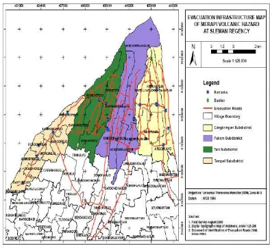
Figure 1. Evacuation infrastructure map as one of mitigation efforts
Besides increasing community awareness, the local government also provides education for the Search and Rescue (SAR) Team. With this training, the skill and expertise of the SAR Team is expected to be enhanced thus they will able to perform search and rescue operations specifically in rugged and mountainous terrain. One more essential effort regarding preparedness is formulation of the Community Emergency Response (CER). It is intended to activate community participation in order to develop proper response during emergency situation.
Institutional Arrangements of Merapi Volcanic Risk Management
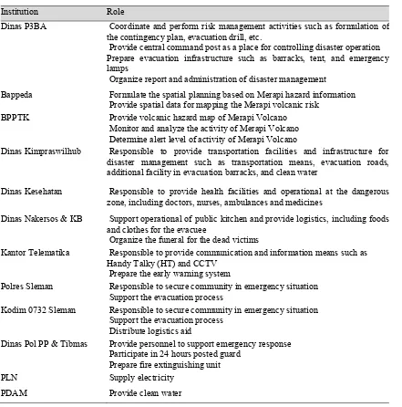
According to the Bupati Act of Sleman Regency No. 26/Kep.KDH/A/2003, in a structural manner Dinas P3BA is pointed as the coordinator of the disaster management activities. The department in Dinas P3BA which handles this function is Department of Natural Disaster Management. Their main duty is to organize operation and management of natural disaster at Sleman Regency. In performing disaster management activities, other institutions are also involved. Bupati Act of Sleman Regency No. 83/Kep.KDH/A/2006 stated these institutions together with their role, as described in the table 1.
From the table 1 we can see that in performing Merapi volcanic risk management activities, Dinas P3BA need to cooperate with other institutions. For example in composing the risk map of Merapi Volcano, Dinas P3BA requires spatial data such as administrative boundary, building, and population density from Bappeda. On the other side, Bappeda also need information about Merapi volcanic hazard and the risk to the community as one of the consideration input in creating the spatial planning for Sleman Regency. Therefore area development at Sleman Regency will be more effective since it accommodate disaster aspect provided by Dinas P3BA.
Table 1. Role of institutions in Merapi volcanic risk management activities
Roles of other institutions are mainly appropriate with their own work function. For example BPPTK provides the hazard map and determine alert level based on recent observation on activity of Merapi Volcano. Another example includes Dinas Kesehatan which prepares health facilities in disaster emergency and response.
Institution Role
Dinas P3BA Coordinate and perform risk management activities such as formulation of the contingency plan, evacuation drill, etc.
Provide central command post as a place for controlling disaster operation Prepare evacuation infrastructure such as barracks, tent, and emergency lamps
Organize report and administration of disaster management
Bappeda Formulate the spatial planning based on Merapi hazard information Provide spatial data for mapping the Merapi volcanic risk
BPPTK Provide volcanic hazard map of Merapi Volcano Monitor and analyze the activity of Merapi Volcano Determine alert level of activity of Merapi Volcano
Dinas Kimpraswilhub Responsible to provide transportation facilities and infrastructure for disaster management such as transportation means, evacuation roads, additional facility in evacuation barracks, and clean water
Dinas Kesehatan Responsible to provide health facilities and operational at the dangerous zone, including doctors, nurses, ambulances and medicines
Dinas Nakersos & KB Support operational of public kitchen and provide logistics, including foods and clothes for the evacuee
Organize the funeral for the dead victims
Kantor Telematika Responsible to provide communication and information means such as Handy Talky (HT) and CCTV
Prepare the early warning system
Polres Sleman Responsible to secure community in emergency situation Support the evacuation process
Kodim 0732 Sleman Responsible to secure community in emergency situation Support the evacuation process
Distribute logistics aid
Dinas Pol PP & Tibmas Provide personnel to support emergency response Participate in 24 hours posted guard
Prepare fire extinguishing unit PLN Supply electricity
Evacuation Planning of Merapi Volcano Disaster
Evacuation planning is the activity to arrange the evacuation process of the villagers living in the danger zone in order to locate them to a safer location. In terms of Merapi Volcano disaster, Sleman Government includes the arrangement of evacuation in the contingency plan. Evacuation planning is organized for villages and sub-villages at Kecamatan Pakem, Cangkringan, and Turi which have been determined as highest risk area according to the risk map of Merapi Volcano. The planning aims to minimize casualties and to prepare facilities and infrastructures needed in the evacuation process.
Eventhough the Bupati act of Sleman Regency No. 3/Kep.KDH/A/2006 has stated operation procedure of evacuation process, in reality experience from the 2006 eruptions had revealed some common hindrances. Inadequate allocation of medical services in evacuation barracks is still happened as many of the evacuees have not received gas mask to prevent from volcanic ash. Consequently, some of them were coming down with respiratory infection [Kedaulatan Rakyat, 2006]. Another emerged issue was related with the condition of evacuation roads [Tupai, 2006].
Immediate identification of damaged and impassable roads is essential as an input for the local authorities to perform appropriate reparation or maintenance. Moreover, there was also a problem regarding livestock of the villagers. Many of them were returned to their villages during evacuation phase because worried that their livestock and crops would be vulnerable to theft [Antara, 2006]. The local government needs to determine places and strategies to relocate these cattle.
Local SDI at Sleman Regency
At national level, regulation concerning implementation of SDI has been arranged by the Presidential Act No. 85/2007. The importance of local SDI implementation has been recognized by Sleman Government. However, the development of local SDI at Sleman Regency is still in the initial phase, only a few initiatives have been conducted. Based on the interview results with official from Bappeda, the initiative had started since 2008 by dissemination of the advantages of a local SDI. In the following year the programme is enhanced by formulating local regulation draft as a foundation to implement local SDI for Sleman Government. So far, this rule is still under discussion and expected to be declared in 2010. Apart from legal development, the local government has begin to prepare a single-base map of Sleman Regency and plans to establish a project for creating metadata of all spatial data in the following year.
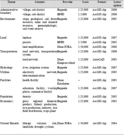
(1:25,000). This might be insufficient for programs that need more detail information such as urban planning or land system in sub-districts level. BPPD had started to utilize larger scale information from Ikonos image in 2005 and had produced administrative boundary and land parcel maps with scale of 1:5,000.
Table 2. Spatial data available at Sleman Regency
Theme Contents Provider Scale Format Latest update Administrative
boundary
village, sub-district Bappeda 1:25,000 ArcGIS shp 2006
village, sub-district BPPD 1:5,000 ArcGIS shp 2006
Environment slope, geological, soil, forest resource, mine and mineral resource, geomorphologic, soil water reserve
Bappeda 1:25,000 ArcGIS shp 2005
Land landuse Bappeda 1:25,000 ArcGIS shp 2007
parcels BPPD 1:5,000 ArcGIS shp 2005
land amplification Dinas P3BA 1:50,000 ArcGIS shp 2008
Transportation road network, transportation system
Bappeda 1:25,000 ArcGIS shp 2006
road network Dinas
Kimpraswilhub
1:25,000 AutoCAD 2005
Hydrology river, irrigation system Bappeda 1:25,000 ArcGIS shp 2007 Utilities electricity network,
telecommunication
Bappeda 1:25,000 ArcGIS shp 2005
Facilities health facility Dinas Kesehatan
-- ArcGIS shp 2005
education facility, worship places, commerce facility
Bappeda 1:25,000 ArcGIS shp 2007
Population density Bappeda 1:25,000 ArcGIS shp 2005
Economics gross regional domestic product, fishery production, rice production, industry, rice field distribution, crops plant
Bappeda 1:25,000 ArcGIS shp 2005
Natural Hazards Merapi volcanic risk, landslide, drought, cyclone
From the inventory it was identified several duplication in term of spatial data provision. For example road network which was provided by Bappeda and also Dinas Kimpraswilhub. Although both of the data are in same scale but the format and feature catalogue is different. Bappeda distinguishes road into five classes (national, collector, local, other, and footstep road) whilst Dinas Kimpraswilhub uses three classes (national, provincial and regency road). Meanwhile, based on the questionnaire results all the institutions involved in Merapi volcanic risk management have spatial data whether in digital or hardcopy format. However, only about 27% of the spatial data are completed with the metadata. This indicates not all institutions are aware about the importance of metadata. The spatial data generally used in problem analysis, instruments in meeting and also tools for field survey. In term of spatial data access and sharing, most of the respondents (68%) experienced that accessing spatial data from other institutions is not difficult. There are two main methods to know what spatial data are available at institutions, firstly by searching in the catalog and secondly by asking directly to official. Giving the digital maps in CD/DVD is the most common method of data sharing compared to providing the print out maps and online maps. However there are some problems experienced when they integrating the data such as different scale/resolution, different format and inconsistent features of the spatial data.
Development of the Prototype User Requirements
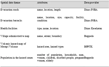
The fieldwork questionnaire responses revealed the requirements of the users, needed to design an application for evacuation planning of Merapi Volcano disaster. These requirements referred to the spatial data for evacuation planning and the geospatial web services required in the application. According to the respondents there were at least six data types needed by the local agencies in the process of making evacuation plan. Table 3 lists these data types.
Table 3. Requirement of spatial data for evacuation planning
Spatial data theme Attributes Data provider
Evacuation roads name, location, length Dinas P3BA
Evacuation barracks
name, location, size, capacity, facility,
condition Dinas P3BA
Health facilities type, name, location Dinas Kesehatan
Village administrative map name, extent, boundary Bappeda
Volcanic hazard map of
Merapi Volcano hazard area, hazard types BPPTK
Population in the hazard zones
number of population, households, man, women, children, disabled people, pregnant women, elderly
Bappeda
In addition to the prerequisites resulting from survey, there were additional requirements in terms of information sources and needs during evacuation process. Examining the standard operation procedure of emergency response and analyzing relevant documents (such as the contingency plan and mitigation reports) helped to determine information sharing requirements. The focus was on four local agencies only; those considered the most significant in the evacuation planning. The resulting information needs can be distinguished by three phases i.e. pre, during and post evacuation.
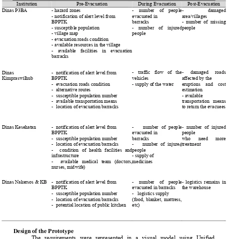
Table 4. Information needs in evacuation process
Institution Pre-Evacuation During Evacuation Post-Evacuation Dinas P3BA - hazard zones
- notification of alert level from BPPTK
- susceptible population - village map
- evacuation roads condition - available resources in the village - available facilities in evacuation barracks
- number of people evacuated in
barracks
- number of injured people
- damaged area/villages
- number of missing people
Dinas
Kimpraswilhub
- notification of alert level from BPPTK
- evacuation roads condition - alternative routes
- susceptible population number - available transportation means - location of evacuation barracks
- traffic flow of the vehicles
- supply of the water
- damaged roads affected by the
eruptions and cost estimation
- available
transportation means to return the evacuees
Dinas Kesehatan - notification of alert level from BPPTK
- susceptible population number - location of evacuation barracks - condition of health facilities and infrastructure
- available medical team (doctors, nurses, midwife)
- number of people evacuated in
barracks
- number of injured people
- supply of medicines
- number of injured people
who need more treatment
Dinas Nakersos & KB - notification of alert level from BPPTK
- susceptible population number - location of evacuation barracks - potential location of public kitchen
- number of people evacuated in barracks - logistics supply (food, blanket, mattress, etc)
- logistics remains in the warehouse
Design of the Prototype
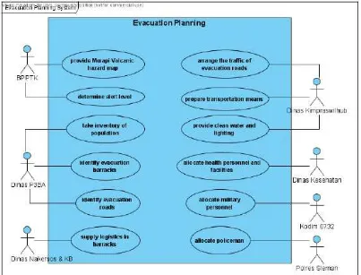
A use case diagram enables the system designer to discover the requirements of the target system from the user’s perspective (Tsang et al., 2005). Therefore the data collected during the fieldwork supported the creation of a use case diagram. This diagram describes which actors are involved and which actors have which roles in evacuation planning. The use case diagram in Figure 2 identifies seven institutions with significant functions. This model was used as the basis to determine the users who will operate the prototype.
Figure 2. Use case diagram of the evacuation planning system
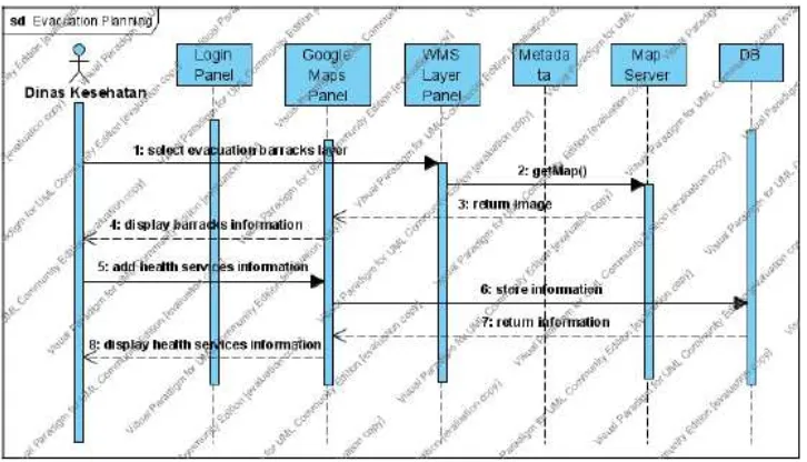
Secondly, a UML sequence diagram helped to show the interaction of messages between objects in the prototype. This diagram has two dimensions: the vertical dimension and the horizontal dimension, respectively representing the
The purpose of login is to manage the access rights on the maps, in such a way that only recognized users may obtain access. Consequently, unauthorized users will not be able to add invalid information on the maps. After a user has successfully entered the system, the Google Maps Panel displays a satellite image of the Sleman Regency. Then, the user can select any available thematic map – in this case: any map which may be required for evacuation planning (supported by its metadata information). The prototype facilitates a user to add any information to the selected map. This include appending new points, lines, and polygons within the Google Maps, and attaching relevant and significant additional attribute information on those objects. The information inserted by the user is saved in the database, thus enabling other users to view it.
[image:16.612.126.489.373.581.2]An example of a detailed sequence diagram for evacuation planning is presented in Figure 3. Based on the use case diagram, Dinas Kesehatan has responsibility in the allocation of health personnel and facilities. This task can be achieved by making use of the prototype. First, Dinas Kesehatan had to know recent situation at evacuation barracks in order to determine appropriate health services. The information can be found in the WMS Layer Panel provided in the prototype. Subsequently, after recognizing this information, allocation of the health personnel and facilities can be deployed by using add annotation facilities in the maps presentation.
Geospatial Web Services Development
One of the user requirements is to provide a portrayal service in the prototype. The collection of data required for evaluation planning preceded the creation of the services in the prototype. The prototype only used data from the Kecamatan Pakem, Turi and Cangkringan, since the evacuation planning prioritized these sub-districts. OGC Web Map Service (WMS) and OGC KML (formerly Keyhole Markup Language) could accommodate this prerequisite.
WMS is a standard protocol for serving georeferenced map images over the Internet that are generated by map server using data from a GIS file. WMS maps can be presented in a pictorial format such as PNG, GIF or JPEG, or as vector-based graphical elements in Scalable Vector Graphics (SVG) format. The OGC defines KML as an XML language focused on geographic visualization, including annotation of maps and images. Geographic visualization includes not only the presentation of graphical data on the globe, but also the control of the user's navigation in the sense of where to go and where to look. From this perspective, KML is complementary to most of the key existing OGC standards including GML, WFS and WMS.
MapServer was the software tool used to implement the WMS instances. WMS was created for the sub-districts boundary theme. The initial preparation of the spatial data used ArcGIS. Then followed the creation of a Mapfile (which is a text file required by the MapServer). The Mapfile described the relationships between the objects. Additionally, it points the MapServer to where data are located, and it defines how things are to be drawn. Some software such as ArcMap, Quantum GIS, and uDig are providing WMS client support. Figure 4 presents the WMS of Sub-district boundary of Kecamatan Pakem, Turi and Cangkringan accessed from ArcMap version 9.2.
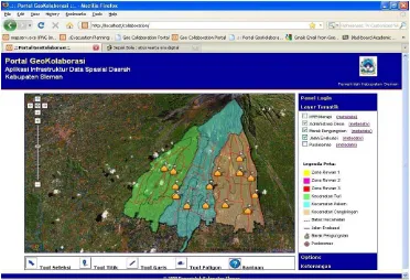
Customization of The GeoCollaboration Portal
The author utilizes GeoCollaboration Portal (Aditya, 2008) – an application of a local SDI developed by Dr. Trias Aditya, for implementation of the prototype. The GeoCollaboration Portal aims to support decision makers investigate, analyze and provide alternative solutions when dealing with disaster management at Yogyakarta Province. It facilitates data sharing through availability of enhanced map interface where various WMS layers can be cascaded synchronously. It provides synchronous annotation which can be used to share information among local agencies. GeoCollaboration Portal was built using PHP programming and improved with MySQL database in the server side while the map presentation was developed using Google Maps API.
[image:18.612.120.492.360.614.2]In this research several customizations to the Portal were made. With the aim to make the Portal prototype for a local SDI implementation, it supports the evacuation planning conducted by Sleman Regency government. The foremost adjustment regarded the data layer. All the created geospatial web services were integrated in the prototype. A total six spatial resources are available in the prototype: the Sub-district boundary, the Merapi volcanic hazard zones, the village administrative boundaries, the evacuation barracks, the evacuation roads, and the Health facilities (Puskesmas).
In addition to the data layer adjustment, a new map legend for all data layers was a first enhancement to the prototype. The legend can help users to understand which features are available in the layer. A second enhancement was the generation of metadata for each data layer. The metadata consist of information regarding the spatial data and created based on the FGDC s metadata standard. With these metadata, users were able to view for example, description of the spatial data and also its contact information. Another enhancement was creation of a help file in the prototype. This help file provides the user with a guideline in how to utilize specific elements of the prototype. An adjustment was also made in the user list of the prototype. From the use case diagram in the design phase, one can determine which user can operate the prototype. There are four local agencies considered as the users i.e. Dinas P3BA, Dinas Kimpraswilhub, Dinas Kesehatan and Dinas Nakersos & KB.
Evaluation of the Prototype Overview
The purpose of conducting assessment test for the prototype of a local SDI application is to determine effectiveness, satisfaction and accessibility of the application. In addition, the assessment also aims to determine usefulness of the prototype in supporting evacuation planning activities for Merapi Volcano disaster. The testing also included a group discussion in order to elaborate user expectation and opinions concerning issues of local SDI related with the application. Usability data was collected using observation and questionnaire method while the group discussion was conducted in a structured way with predefined questions. The questionnaire was created using likert scales format which measures participant as level of agreement to a statement regarding usability issues. Participants of the evaluation are representatives from local agencies involved in evacuation planning of Merapi Volcano Disaster, specifically Dinas P3BA and Dinas Kesehatan. Moreover Bappeda which has significant role in the implementation of local SDI was also present.
during the session. These comments were noticed as one of significant input – beside the remarks collected from the group discussion, for further development of the prototype. Evaluation Results.
From the observation data it was recorded that all of the participants completed their tasks successfully and they were able to access the prototype using different internet browser. On the subject of usefulness, results of the questionnaire expressed that 83% of the answers were described user agreement while the rest is still uncertain. All users have the same opinion that spatial data available in the prototype were required to support activities of evacuation planning. They were satisfied with the information embedded in the thematic maps as for example they could find number of population data when they click a village in village administration layer. They were also pleased with the prototype as capability to create annotation on maps since they utilized this facility in order to finish the tasks. It was proven that by using this function, a user could provide recent information in term of evacuation process, such as number of evacuees or location of damaged roads.
The users found the prototype was reasonably effective as they were able to explore and perform some interactions with the maps presentation. Moreover, in terms of prototype as feature in providing spatial data required for evacuation planning, 100% of the users were able to find those data which provided by different local agencies. Response from the questionnaire also illustrated their satisfactions with the user interface and content of the prototype. In case of the metadata, most users were pleased since it provides valuable information. However one of the participant was uncertain about the metadata elements that was available in English not in Bahasa Indonesia. This note is significant for the improvement of the prototype.
A couple of hindrances were encountered during the evaluation as follow: a. Number of the respondents were not as many as expected before
b. Internet connection was occasionally interrupted when users working with the tasks
CONCLUSIONS
Risk management is indispensable in order to protect and reduce the impact of Merapi Volcano disaster to the community. Sleman Government has been executing hazards identification, risk assessment, mitigation measures and preparedness actions. It is found that in performing these activities spatial data are highly utilized by the local government. There are a couple of important findings related to the risk management activities. First, the risk management required cooperation and coordination among different local agencies. Even though the Bupati Act clearly stated roles of each agency, in its implementation some overlapping functions were occurred. Second, although the local government has produced a standard operating procedure for evacuation process, some general obstacles were identified in the field. It includes insufficient medical services, identification of damaged evacuation roads and livestock dilemma of the villagers. A local SDI could be introduced to overcome such problems.
The study found that in order to support the risk management, local SDI has to be able to provide related spatial resources, access to the data, metadata information, and web services which enables interactions with spatial resources. These functionalities are basis for development of the prototype. It is found that geoportal can be exploited to provide spatial data resources, metadata layer and interactive map presentation. Meanwhile, geospatial web services represented by WMS and KML files were generated to supply the spatial data to the geoportal. From this research it is found that users of the prototype have in the same agreement concerning the advantage of a local SDI to support the evacuation planning. However, some suggestions were also recorded for the next prototype development.
RECOMMENDATIONS
Recommendations for future research are as follows:
a. This research is limited on spatial data utilization by local government agencies. Since users of the local SDI are not only from government institutions, further studies should incorporates data from other stakeholders.
b. This research is mainly discussed on the technological aspect of a local SDI. Other components, which are significant to local SDI development, are not detailed. Further studies concerning legal, institutional or human resources aspects are required.
d. This research is focused on evacuation planning activities of Merapi Volcano disaster. Studies on other risk management activities or other hazards types will enrich utilization of a local SDI application.
REFERENCES
Aditya, T. (2008), A Usable local geospatial data infrastructure for improved public participation and collaborative efforts in enhancing community preparedness and mitigation. International Conference on Tsunami Warning (ICTW), 12-14 November, Bali.
Aditya, T. and M.-J. Kraak (2009), Geoportals and the GDI Accessibility.
Handbook of Research on Geoinformatics. Information Science Publishing: Hershey, 42-50.
Antara (2006), Perintah Gubernur DIY untuk evakuasi warga belum dilaksanakan.<http://www.antara.co.id/view/?i=
1145711365&c=NAS&s=>[18 Desember 2009]
Asante, K.O., J.P. Verdin., M.P.Crane., S. A.Tokar and J.Rowland., (2006), The Role of spatial data infrastructure in the management of natural disasters.
9th GSDI Conference Proceedings, 6 -10 November, Santiago.
Crompvoets, J., A. Bregt., A.Rajabifard and I.Williamson (2004), Assessing the worldwide developments of national spatial data clearinghouses.
International Journal of Geographical Information Science, 18(7), 665-689.
Dinas P3BA (2009), Rencana kontijensi letusan Gunung Merapi, Yogyakarta. Doyle, A., and C.Reed (2001), Introduction to OGC Web Services, OGC White
paper.
Groot, R., and J. McLaughin (2000), Geospatial data infrastructure: concepts, cases and good practice, Oxford University Press.
Hadikusumo (1970), Data kegiatan merapi setelah letusan Januari 1969 sampai akhir tahun 1970, Dinas Vulkanology, Yogyakarta.
Itoh, H., J. Takahama., M. Takahashi,., and K. Miyamoto (2000), Hazard estimation of the possible pyroclastic flow disasters using numerical simulation related to the 1994 activity at Merapi Volcano. Journal of Volcanology and Geothermal Research Vol. 100(1-4): 503-516.
Kedaulatan Rakyat (2006), Hirup abu, banyak warga sesak nafas. Minggu, 11 Juni 2006. (in bahasa).
Maguire, D.J. and P.A. Longley (2005), The emergence of geoportals and their role in spatial data infrastructures. Computer, Environment. and Urban Systems ,
29, 3–14.
Mansor, S., M.A. Shariah,., L.Billa,., I. Setiawan and F. Jabar (2006). Spatial technology for natural risk management. Disaster prevention and management, Vol. 13(5): 364-373.
Mansourian, A., Rajabifard A., Valadan Zoej M.J., Williamson I., (2006), Using SDI and web-based system to facilitate disaster management. Journal of Computers & Geosciences Vol.32: 303 –315.
Masser, I. (2005). GIS Worlds: Creating spatial data infrastructures. Redlands, ESRI
Molina, M., S. Bayarri., R.Vargas (2008), The Andean information system for disaster prevention and relief: A Case study of multi-national open-source SDI. Free and Open Source Software for Geospatial (FOSS4G) Conference, 29 September – 3 October, Cape Town South Africa.
Muller H., St. von and S.Vith (2009), SDI Implementation at the local administration level of Germany.FIG Working Week, 3-8 May, Eilat.
Nebert, D. (2004), Developing Spatial Data Infrastructures: The SDI Cookbook, Version 2.0. GSDI- Technical Working Group.
Nedovic-Budic, Z., M.E. Feeney., A. Rajabifard and I. Williamson (2004), Are SDIs serving the needs of local Planning? Case studies of Victoria, Australia and Illinois, USA. Computers, Environment and Urban Systems,28(4), 329-351.
Newhall, C., S. Bronto., B.V. Alloway., S. Andreastuti, N.G. Banks., I Bahar., M.A. Del Marmol., R.D. Hadisantono., R.T Holcomb., J. McGeehin., J.N. Miksic., M. Rubin., S.D. Sayudi., R. Sukhyar, R.I. Tilling., R. Torley., D. Trimble and A.D. Wirakusumah., (2000), 10,000 Years of explosive eruptions at Merapi Volcano, Central Java: Archaeological and modern implications, Journal of Volcanology and Geothermal Research 100 (1-4), 9–50.
Donnell, V. and D. Birnbaum (2005), Irish Spatial Data Infrastructure Demonstration, Programme on Flood Management: Final Report. Coastal & Marine Resources Centre, University College Cork, Ireland.
Rubin, J. and D. Chisnell (2008), Handbook of usability testing, second edition. Wiley Publishing, Indiana.
Tupai, R. (2006), Merapi eruptions fears prompt tentativeevacuation. <http://www.reliefweb.int/rwarchive/rwb.nsf/db900sid/VBOL-6P2DTR?OpenDocument> [18 Desember 2009].
van Westen, C.J., and P.Y Georgiadou (2001), Spatial data requirements and infrastructure for geologic risk assessment. Proceedings workshop on natural disaster management, ISPRS Technical Committee VII, Ahmedabad.