SATELLITE 'CANOPUS-V' IMAGE PROCESSING TECHNOLOGY DEVELOPMENT
FOR CARTOGRAPHY PURPOSES BASED ON PRELAUNCH SIMULATION
V. V. Nekrasov a *, E. Makushevaa
a
Scientific Research Institute VNIIEM, POB 496, Glavpochtamt, Moscow 101000, Russia,
[email protected]
Commission IV, WG IV/3
KEY WORDS: Cartography, Processing, Adjustment, Orthorectification, Sensor, Georeferencing, Satellite, Accuracy
ABSTRACT:
“Canopus-V” satellite payload consists of two cameras – one of them panchromatic with 2.1 m GSD, another multispectral with 10 m GSD. Navigation system accuracy provides georeference accuracy about 70-80 m without using of control points. The peculiarities of high-resolution panchromatic camera built with micro-frames technology requires to design surveying technology processing for obtaining continuous coverage. Automatic technology of searching tie points in overlapped areas of micro-frames was developed by authors. Block adjustment is done automatic. Rational polynomial coefficients (RPC) calculates after block adjustment for using in standard photogrammetric software. For “Canopus-V” sensors was developed mathematic model and software package for RPC calculating. Searching for tie points use combination of feature and area matching algorithms in overlapped areas of micro-frames. Process of satellite sensors shooting was simulated with use of calibration data (orthophoto, digital elevation model – DEM, control points for test area used as check points). Subpixel accuracy was achieved for block adjustment. Accuracy for resulting orthophoto was checked with control points and was 35-55 m. Using of two control points for block increases resulting orthophoto accuracy two times. Simulation results and accuracy estimation shows that “Canopus-V” panchromatic camera data can be recommended to modify maps for the scales 1:25000. “Canopus-V” multispectral camera data can be used to modify maps for the scales 1:100000.
1. Introduction
In 2012 year in Russia we are waiting for launch two new remote sensing satellites of “Canopus” type. First satellite will be the property of Russia Federation, the second “BKA” will be the property of Belorussia. The launch of both satellitetes will be done with the help of one carrier rocket. “Canopus-V” satellite is intended first of all for monitoring and allow to decide next tasks:
monitoring of anthropogenic and natural emergency;
disclosure of forest fire, environmental pollution;
earthquake forecast;
agriculture monitoring, water resources monitoring;
land use state;
quick observation of earth surface.
Beside all this tasks “BKA” satellite must allow to decide cartographic tasks – renovation of cartographic and geoinformation products. Both satellites has identical equipment with the same parameters, therefore “Canopus-V” satellite data can be used to solve cartographic tasks also.
This article has main purpose to define conditions and technology for using “Canopus-V” and “BKA” data for cartography, it means for geometrically correct coverage of earth surface. Main tasks which will be solved in this work is to develop technology of generating:
correct and exact definition of PSS and MSS sensor micromatrix with the help of RPC;
adjusted block of micromatrix for track shooting of “Canopus-V” satellite;
synthesize and metrically correct coverage for track not less than 23*10 km with RPC georeference;
digital elevation model from multispectral sensor MSS data of “Canopus-V” satellite.
2. Satellite “Canopus-V” images processing technology
2.1. Satellite “Canopus-V” features
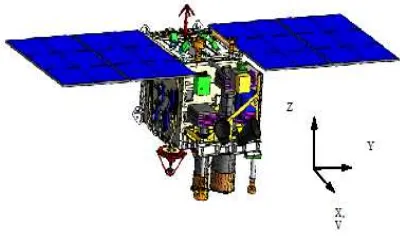
General view of satellite “Canopus-V” and axis orientation are shown on figure 1.
Figure 1. General view of “Canopus-V” satellite.
Main technical characteristics of “Canopus-V” satellite are shown in table 1.
Satellite will be launched on sun-synchronous orbit with height 510 km.
Thanks to big roll and pitch angles of satellite swath width will be about 920 km. Radio visibility with this orbital parameters will be about 1200 km. Span width for PSS sensor will be 23.3 km, for MSS sensor span width will be 20.1 km
International Archives of the Photogrammetry, Remote Sensing and Spatial Information Sciences, Volume XXXIX-B4, 2012 XXII ISPRS Congress, 25 August – 01 September 2012, Melbourne, Australia
Orbital characteristics
Orbit type Circular,
sun-sychronous
Orbit height, km 510
Inclination, degrees 97,447˚
Satellite characteristics
Weight, kg 400
Payload weight, kg 110
Lifetime, years 5-7
Orientation accuracy Not more than
5 arc seconds Maximal roll, pitch angles, degrees ± 40˚ Orientation accuracy, arc seconds 5
Revisit time, days 15
Payload equipment characteristics
quantization width, bits 12
On board storage 24 Gb
Information storing time Not less than 5 days Radio link quantization width, bits 8
Data transmission radiochannels 2
Bandwidth 61,44 or
122,88 Mbit/s
Time maximal error Not more than
0,1 ms Payload work time on one round Shooting 700
sec and 700 sec
transmitting data
Table 1 Main technical characteristics of “Canopus-V” satellite.
Shooting scheme is shown on figure 2.
Figure 2. Shooting scheme of “Canopus-V” satellite.
Payload equipment consists of two sensors – panchromatic (PSS – panchromatic shooting sensor) and multispectral (MSS – multispectral shooting sensor) which allow to get image in four spectral bands – near infrared, red, green, blue. Shooting may be done simultaneously in panchromatic and multispectral modes and also with different combinations of spectral bands or only in one spectral band. Main technical characteristics of PSS and MSS sensors are shown in table 2.
Characteristic PSS MSS
Spectral bands 1 4
Spectral bands (with level 0,5),
mkm
Panchromatic (0,52–0,85)
Blue (0,54–0,6)
Green (0,63–0,69)
Red (0,69–0,72)
Near IR (0,75–0,86)
Focal length, mm 1797,5 359,5
Relative hole 1:10,3 1:5,6
Transmittance 0,7 0,6–0,8
Matrix size, pixels 1920х985 1920х985
Nadir shooting
span width, km 23,3 20,1
GSD, m 2,1 10,5
Ground resolution, m 2,7 12 Shooting square, square km 45,3 (6
frame fragments)
195
Table 2 Main characteristics of panchromatic and multispectral sensors.
MSS sensor geometry is frame camera sensor, but if has some
feature – it CCD matrixes for different spectral bands dispersed in focal plane (see figure 3). With this feature multispectral images may be done only in overlapped areas during satellite movement. But technology of multispectral synthesis will be the theme of another article.
Figure 3. MSS micromatrix placement in focal plane.
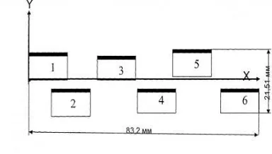
This work will be devoted to processing technology of PSS sensor data.The main feature of PSS sensor – it is done from different CCD micromatrixes. Scheme of matrix placement is shown on figure 4.
Figure 4. PSS micro matrixes placement in focal plane. International Archives of the Photogrammetry, Remote Sensing and Spatial Information Sciences, Volume XXXIX-B4, 2012
XXII ISPRS Congress, 25 August – 01 September 2012, Melbourne, Australia
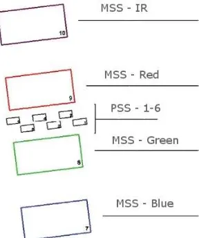
Projection of PSS and MSS sensors on earth surface you can see on figure 5. Span width for PSS sensor (6 CCD matrixes) will be 23.3 km, for MSS sensor (4 CCD matrixes) span width will be 20.1 km
Figure 5. Projection of PSS and MSS sensors on earth surface.
2.4. Source data modeling
For developing technology source data were obtained by modeling sensors and shooting jf “Canopus-V” satellite [Nekrasov,2010]. Modeling images were done with the help of next technology [Nekrasov,2011]. High resolution image of “Resurs-DK-1” satellite was get for whole area of experimental testing area. Heights differens of testing area is about 400 m. We used digital elevation model (DEM), which was processed from SRTM (Shuttle Radar Topographic Mission) data. Orthoimage was processed using this hi-resolution image and DEM. GSD for orthoimage is 1 m, accuracy of external orientation is about 2.11 m. Orthoimage and DEM used as source data for creation of simulated images of “Canopus-V” PSS and MSS sensors. External orientation of simulated images is defined with the help of rational polynomial coefficients (RPC). RPC were calculated with errors of navigation system for simulation of real shooting conditions.
2.5. Methods, algorithms
RPC are based on next equations, connecting ground geodetic coordinates with image coordinates:
)
Nominator and denominator of this equations are polynomials of third degree:
Normalization of pixel and geodetic coordinates is done according next equations. Normalized values of coordinates will be not more than 1:
RPC calculation will be done according such algorithm:
Calculate external orientation parameters for image according rigorous sensor model and using control points (or we can use external orientation parameters calculated from navigation data);
Calculate for all image and heights evenly distributed control points (xf, yf, X, Y, Z) using rigorous sensor model;
Create equations and solve system with the help of least mean square method, for RPC determination.
Tie points were searched in overlapped areas of CCD matrixes. First video data lines placed in focal plane to overlap each third frame of next matrix with first frame of previous matrix. Video data frame consists of 985 lines. Every next frame in MSS has overlap with previous frame in 57 lines. In PSS every next frame has overlap with previous frame in 80 lines. Between frames of different matrixes overlap is about 70 pixels.
We use combination of area matching algorithms and SURF for tie points search.
Block adjustment is done with the account of CCD matrixes in focal plane and using RPC. For block adjustment with tie points we use additional information about surface heights from digital elevation model or average height of earth surface.
One of output products is synthesized coverage with sizes from 23*10 to 23*20 km. This product can be used for increasing productivity of image processing. Whole pixel coverage for interesting area is done from adjusted block of images excluding overlapped areas. RPC calculated for such synthesized coverage.
While moving along orbit arises overlap of frames in different spectral bands for MSS sensor “Canopus-V” satellite. We have possibility to get digital elevation model by combined International Archives of the Photogrammetry, Remote Sensing and Spatial Information Sciences, Volume XXXIX-B4, 2012
XXII ISPRS Congress, 25 August – 01 September 2012, Melbourne, Australia
processing of multispectral data. Main feature of such processing is in point correlation from different spectral bands data. One more feature of such data is low ratio B/H. And we must estimate possible accuracy of such processing.
3. Experimental results
Calculating RPC for PSS CCD matrixes, accuracy (RMS) of coefficient calculation for testing area is from 0.000693 to 0.001306 pixels for normalized pixel coordinates.
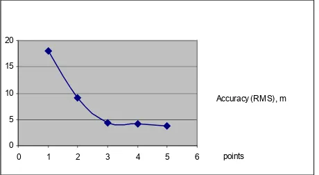
We use correlation coefficient not less than 0.9 for searching tie points. Bad tie points excludes in block adjustment of CCD matrixes for subpixel accuracy of block adjustment. For testing area we get block adjustment accuracy from 0.1 pixel to 0.8 pixel (RMS) depending from block size. Georeferencing accuracy for testing area without control points is defined by navigation system accuracy and in simulation was set for position – 10 m (RMS) and for orientation angles 10 arc seconds (RMS) it will be equal to 80-100 m (RMS) on earth surface. Using additional control points radically increases block georeference accuracy (see figure 6). One control point increases georeference accuracy to 18 m (RMS), three control points decreases error to 4.3 m (RMS), in such case we have good block adjustment with tie points along and across track.
points 0
5 10 15 20
0 1 2 3 4 5 6
Accuracy (RMS), m
Figure. 6. Georeference accuracy of CCD matrixes block
External orientation accuracy for synthesized coverage with 7 control points is 3.5m.
Relative orientation accuracy of stereopair from multispectral images for testing area:
RMS: 0.464 Average: 0.397 MAX: 0.834 Points quantity: 30
External orientation accuracy of stereopair with 4 control points is equal to 26.7 m (RMS).
External orientation accuracy of stereopair with 7 control points is equal to 17.2 m (RMS).
We compared source digital elevation model (from SRTM data) which was used for simulated images with calculated DEM.to Height errors were:
RMS: 21.2 м, MAX: 32.3м.
4. Discussion
Results of this work may be used as guideline in using of “Canopus-V” and “BKA” data. Meanwhile we must remember that this results were get from simulated data. Simulation must be obligatory in designing of new remote sensing satellites and simultaneously, processing technologies of data from this satellites.
5. Conclusions
Results of simulation and accuracy estimation shows, that panchromatic sensor data of “Canopus-V” satellite may be recommended to modify maps for the scale 1:25000 . Multispectral sensor MSS data may be used to create and modify maps for scale 1:100000. Using of adjusted block of CCD matrixes allow to use “Canopus-V” sensor features with maximum accuracy. Synthesized coverage with RPC georeference allow to increase productivity of image processing. We demonstrated possibility of DEM generation in this work. But because of small ratio B/H it accuracy is not very high, meanwhile it may be recommended for using in processing for scales 1:100000 and less.
6. Acknowledgements
We would like to thank Nikonov Oleg - head of remote sensing department of VNIIEM corporation for his active support of this work.
References
Vladimirov A.V., Salikhov R.S., Sennik N.A., Zolotoi S.A.,
2008. Space system for operative monitoring of technogenic and natural emergency situations on base of space complex “Canopus-V” and Belorussia space satellite. Electrician
problems, 105(1), pp. 49-57.
Nekrasov V.V., Makusheva E.V., 2010. Development of dynamic geometrical model of shooting of optoelectronic sensors for perspective space complexes “Canopus-V” type.
Electrician problems,119(5), pp. 25-30.
Nekrasov V.V., Kravtsova E.V., 2011. Processing technology in DPS PHOTOMOD images of perspective satellite “Canopus-V”. Geoprofi, 5.2011, сс. 15-18.
International Archives of the Photogrammetry, Remote Sensing and Spatial Information Sciences, Volume XXXIX-B4, 2012 XXII ISPRS Congress, 25 August – 01 September 2012, Melbourne, Australia