THE FRACTURES ANALYSIS FOR ACTIVE FAULT DETECTION
ON CIPARAY REGION IN SOUTHERN MARGIN OF THE BANDUNG BASIN,
JAWA BARAT PROVINCE, INDONESIA
Emi Sukiyah1)
1)
Doctorate Candidate of Mathematic and Natural Sciences, Padjadjaran University, Bandung.
ABSTRACT
The research area is located at southern part of Bandung Regency, belong to the Ciparay District. The area is characterized by the valley and hill with steep angle slope reaching 60%. It was sited by volcanic rocks of Waringin-Bedil Mounts at Early Pleistocene, Malabar-Tilu Mounts at Late Pleistocene, lake deposite at Holocene, and alluvial at Recent. The objects of research are fractures population and river segments that develop on active fault zone. Measurement is undertaken on the azimuth directions of the number of fractures and river segments. Research methods used are fractures analysis and bifurcation ratio. The azimuth directions of fractures and river segments are analyzed with statistic to get accurate verification. Result of research shows that area is controlled by active fault.
Key-words: fractures analysis, active fault, statistic, verification. .
ABSTRAK
Daerah penelitian berada di bagian selatan Kabupaten Bandung, termasuk wilayah Kecamatan Ciparay. Kawasan tersebut dicirikan oleh lembah dan lereng bukit terjal dengan sudut lereng mencapai 60%. Litologi penyusun daerah penelitian adalah batuan vulkanik berumur Kuarter yang merupakan produk Gunung Waringin-Bedil berumur Plistosen awal, Gunung Malabar-Tilu berumur Plistosen akhir, endapan danau berumur Holosen, dan aluvium yang hingga kini masih terbentuk. Objek penelitian berupa populasi kekar dan segmen sungai yang berkembang pada zona sesar aktif. Pengukuran dilakukan pada arah azimut sejumlah kekar dan segmen sungai. Metode penelitian yang digunakan adalah analisis arah azimut kekar dan rasio cabang sungai. Arah azimut kekar-kekar dan segmen sungai dianalisis menggunakan statistik untuk memperoleh verifikasi yang memadai Hasil penelitian menunjukkan bahwa daerah penelitian secara signifikan dikontrol oleh sesar aktif.
Kata kunci: analisis kekar, sesar aktif, statistik, verifikasi.
INTRODUCTION
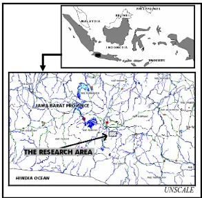
The research area is characterized by valley among two mountains namely Bukitcula (1.073 m) and Pasir Nini (1.096 m). The slope is steep with slope angle reaching 60% at the eastern slope of Pasir Nini Mountain. Administratively, this area belongs to Ciheulang Village, Ciparay district, Bandung Regency, Jawa Barat Province, Indonesia (FIGURE 1).
This area is attracting several investors in property field. There is recently property development that now already occupied the slope of Pasir Nini Mount. Many supported factors for the
development of property exist in this area. These are compact lithology that good for fondation, spring water on the fault plane, and the good accessibility to the main road of Bandung-Majalaya.
METHODOLOGY
Mind frame of this research follow to deductive pattern. Principally, the strike slip fault was found at that area. Furthermore, variable of structure and landform have measured were analysed and due testing with statistic test to get acurate result. Statistic or probability approach for know fault state with specific conviction grade.
The research method that used is fractures analysis method to get common directions of fractures on active fault zone. This result is compared with common direction of river segments that lied on same as area. Measurement result is test with t-test on significance level (for example 95%). Furthermore, the data are analyzed with probability approach. Statistic test was used are x2 method (formula 1) to know normality of data distribution and t-test (formula 2) to know that river patern is controlled by fracture patern at degree of error (α) is 5%.
x
2= (f
o-f
e)
2/f
e... (1)
With x2 (quadratic chi of calculation result) fo
(total of observation data), fe (total of expectation
data) (after Sugiyono, 1999).
I x – y I
t =
... (2)√
[(
σ
x
2/
Σ
nx) + (
σ
y
2/
Σ
ny)]
With t (t of calculation result), x (average of fractures data), y (average of river segments data),
σx (deviation standart of fratures data), σy (deviation standart of river segments data), Σnx (total of fratures data) and Σny (total of river segments data) (after Krumbein, 1965).
Bifurcation ratio (Rb) is a total of grade river “n” is divided by total of grade river “n+1”. If
Rb<3
or Rb>5 then that watershed area is controlled
by active fault (after Verstappen, 1983).
Materials and tools that used in this research are:
1)
Topographic map with 1: 25.000 scale;2)
Geological map with 1:100.000 scale;3)
Field survey tools, i.e. compass, geologic hammer, loupe, camera, etc.;4)
Computer with its peripheral to support data analysis.GEOLOGICAL SETTING
The Bandung basin is a plateu is arounded by chain of hilly and mountain. Physiographically, this area included to Bandung zone and Quaternary volcanic (after Van Bemmelen, 1949).
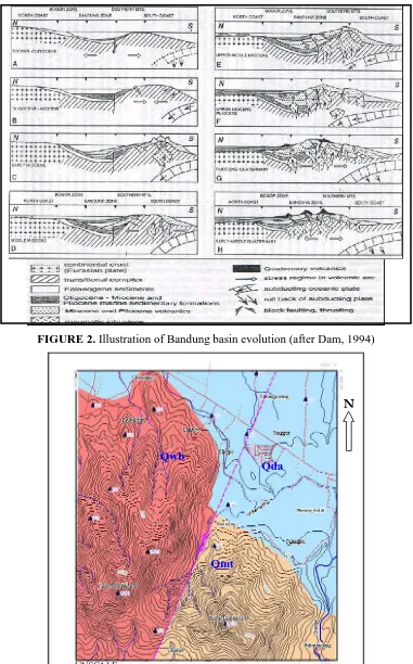
The number of research workers researched geological object in the Bandung Basin, i.e Klompé (1956, in Koesoemadinata, 1979), Silitonga (2003), Alzwar et al (1992) and Dam (1994). FIGURE 2 show ilustration of Bandung Basin evolution since Oligocene to Quaternary (after Dam, 1994).
Alzwar et al (1992) built geological map of Garut and Pameungpeuk sheet in 1:100,000 scale where the research area lied. Lithologic settings of that area are andesite lava, tuff, lake deposits and alluvial (FIGURE 3). Andesite lava can be compared with andesite of Waringin–Bedil (Old Malabar) formed in early Pleistocene. Tuff can be compared with volcanic rock of Malabar-Tilu formed in Late Pleistocene. The lake deposits formed in Holocene and alluvial have been forming to recent.
The geological structure that to develop in research area in the form of oblique fault. This fault coincides with direction of Barugbug River. Fault scarp show in block diagram (FIGURE 4). Barugbug fault is estimated as active fault because it continues to cut through lake deposit.
RESULT AND DISCUSSION
The normality test of data distribution of azimuth directions of river segments and fractures use x2 method. Test result show data are classified normal distribution are indicated by value of “x2calculation < x
2
table“ (TABLE 1). Furthermore, the
parametric statistic can be due for know difference of rivers and fractures patterns.
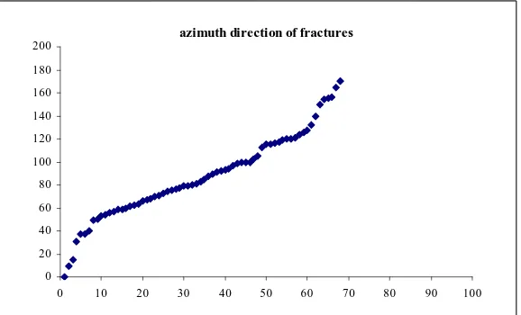
The population of azimuth directions of fractures and river segment are compared use different test with t-test method. Analysis result of four populations show no significant difference among
them where
“tcalculation < ttable” (TABLE 2). Theanalysis results are supported by scatter diagram that indicate similar patterns (FIGURE 5 and 6).
The patterns of rivers and fractures are proven no different. They indicate rivers on Quaternary volcanic rock are controlled by active fault. That phenomena supported by analysis result of bifurcation ratio (Rb) at Barubug River, that estimate on 2 to 2.5 range. That value show watershed area of Barugbug is controlled by active fault.
At the field, object viewing indicates the fault is active. It is showed by infrastructure broken, i.e: 1) Cracking on main road body at housing area
at slope of Pasir Nini Mount (FIGURE 8); 2) Asphalt road at Barugbug sub village crossed
by fault and moving (FIGURE 9 and 10); 3) The flow direction of Barugbug River had
turned to fit road margins back to previous direction to fit azimuth direction of fault cross road body (FIGURE 9).
CONCLUSION AND SUGESSTION
The fault in research area is active fault. It is indicated by rivers pattern are controlled by fractures pattern, value of bifurcation ratio among 2 to 2.5 ranges and moving of infrastructure facility is cut by fault.
The continuity and detail researches should be due to know degree of fault activity. This step is important because that Ciparay Region as housing development to recent.
ACKNOWLEDGEMENT
The author wish to place on record their sincere thanks to Prof. Dr. Adjat Sudradjat, Ir., M.Sc., Prof. Dr. R. Febri Hirnawan and Dr. Dicky Muslim, Ir., M.Sc. for their patience and useful guidance. My thanks are also due to Dr. Ildrem Syafrie, Ir., DEA as Head of Department of Geology, Faculty of Mathematic and Natural Science, Padjadjaran University for research grand to pass the Department of Geology Development Programme 2005.
REFERENCES
Alzwar, M., N. Akbar & S. Bachri. 1992. Geological map of the Garut and Pameungpeuk quadrangle, Jawa, 1:100,000 Scale. Geological Research and Development Centre, Bandung, Indonesia.
Dam, Marinus A. C. 1994. The Late Quaternary
Evolution of The Bandung Basin, West - Java, Indonesia. Thesis. Department of Quaternary
Geology, Faculty of Earth Sciences, Vrije Universiteit, Amsterdam. Unpublised.
Koesoemadinata, R. P. 1979. Geologi Dataran Tinggi Bandung. Proceedings PIT IAGI X.
Krumbein & Graybili. 1965. An Introduction to
statistical Models in Geology. Mc. Graw Hill
Book Company, New York.
Silitonga, P. H. 2003. Peta Geologi Lembar Bandung Jawa, Skala 1:100.000. PPPG, Bandung. Cetakan ke-3.
Sugiyono. 1999. Statistika untuk Penelitian. CV Alvabeta, Bandung. Cetakan ke-2.
Van Bemmelen, R.W. 1949. The Geology of
Indonesia and Adjacent Archipelagoes, General Geology. Martinus Nijhoff The Hague, vol. IA:
25-28.
Verstappen, H. Th. 1983. Applied
Geomorphology: Geomorphological Surveys for Environmental Development. Elsevier Science
Class Object df x2calculation x 2
table
fracture 6 12 12.592
I
river segment 29 35 42.557
fracture 29 27 42.557
II
river segment 15 18 24.996
fracture 23 27 35.172
III
river segment 17 21 27.587
fracture 6 10 12.593
IV
river segment 24 14 35.415
TABLE 1: Result of normality test of data distribution for azimuth directions of fractures and river segments.
Class x y σx σy df tcalculation ttable
I 24.14 20.93 15.94 12.55 35 0.498 1.691
II 68.77 66.06 11.50 11.19 44 0.773 1.681
III 109.92 114.06 12.65 13.08 40 1.029 1.684
IV 155.71 158.12 9.78 11.59 30 0.551 1.697
TABLE 2: Result of difference test show rivers pattern no difference with fractures pattern
UNSCALE
FIGURE 2. Illustration of Bandung basin evolution (after Dam, 1994)
N
Qwb
Qda
Qmt
UNSCALE
FIGURE 3: The geology of research area. Qda (lake deposit and alluvial) formed in Holosen-Recent, Qmt (tuff of Malabar-Tilu volcanics) formed in late Pleistocene, Qwb (andesite lava of Waringin-Bedil or
fault scarp
FIGURE 4: The block diagram of morphology view of Ciparay region
azimuth direction of river segments
0 20 40 60 80 100 120 140 160 180 200
0 10 20 30 40 50 60 70 80 90 100
FIGURE 5: Scatter diagram show pattern of azimuth directions of river segments. Vertical line represents azimuth directions of river segments and horizontal line represents data order.
azimuth direction of fractures
0 20 40 60 80 100 120 140 160 180 200
0 10 20 30 40 50 60 70 80 90 100
(a)
(b)
FIGURE 7: The morphology view of Bukitcula Mount (a) and Pasir Nini Mount (b) FIGURE 7: The morphology view of Bukitcula Mount (a) and Pasir Nini Mount (b)
(Documentation: January 2005) (Documentation: January 2005)
40 cm
FIGURE 8: A fracture breaks a road was built in 1992 at slope of Pasir Nini Mount. A wide of fracture reaching 40 centimetres (documentation: January 2005).
FIGURE 9: The active fault crosses a road at Barugbug sub Village (documentation: January 2005).
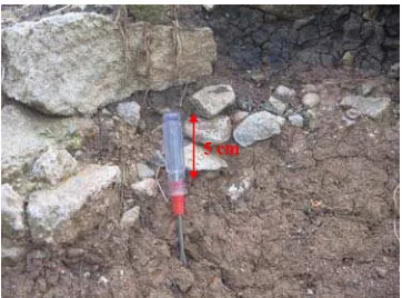
5 cm