Badan Perencanaan Pembangunan Nasional (BAPPENAS)
Jl. Taman Suropati No. 2 Jakarta Pusat 10310 www.bappenas.go.id
ISBN 978-979-3764-49-8 1st Edition
Printed in Indonesia
AUTHORS
Indonesia Climate Change Sectoral Roadmap - ICCSR
Adviser
Prof. Armida S. Alisjahbana, Minister of National Development Planning/Head of Bappenas
Editor in Chief
U. Hayati Triastuti, Deputy Minister for Natural Resources and Environment, Bappenas
ICCSR Coordinator
Edi Effendi Tedjakusuma, Director of Environmental Affairs, Bappenas
Editors
Irving Mintzer, Syamsidar Thamrin, Heiner von Luepke, Philippe Guizol, Dieter Brulez
Synthesis Report
Coordinating Authors: Mitigation: Hardiv Haris Situmeang; Adaptation: Djoko Santoso Abi Suroso
Scientiic Basis and Sectoral Reports
Authors: Ibnu Soian, Tri Wahyu Hadi, Hardiv Haris Situmeang, Meirios Moechtar, Wendranirsa, Iwan Adhisaputra, Nur Masripatin, Ngaloken Gintings, I Wayan Susi Darmawan, Asep Sofyan, Enri Damanhuri, Agus Wahyudi, Endang Supraptini, Anandita Laksmi Susanto, Anja Rosenberg, Nicolette Boele, Bona Frazila, Ko Sakamoto, Irawan, Oman Abdurrahman, Budhi Setiawan, Supratman Sukowati, Juli Soemirat Slamet, Hamzah Latief, M. Suhardjono Fitrianto, Wilmar Salim, Eleonora Runtunuwu, Medrilzam.
Technical Supporting Team
Chandra Panjiwibowo, Indra Ni Tua, Edi Riawan, Wahyunto, Hendra Julianto, Leyla Stender, Tom
Harrison, Ursula Flossmann-Krauss
Administrative Team
Altamy Chrysan Arasty, Risnawati, Rinanda Ratna Putri, Siwi Handinah, Wahyu Hidayat, Eko Supriyatno,
Rama Ruchyama, Arlette Naomi, Maika Nurhayati, Rachman
ICCSR - SYNTHESIS ROADMAP
ACKNOWLEDGMENTS
The Indonesia Climate Change Sectoral Roadmap (ICCSR) is meant to provide inputs for the ive year Medium-term Development Plan (RPJM) 2010-2014, and also for the subsequent RPJMN until 2030, laying particular emphasis on the challenges emerging in the forestry, energy, industry, agriculture, transportation, coastal area, water, waste and health sectors. It is Bappenas’ policy to address these challenges and opportunities through effective development planning and coordination of the work
of all line ministries, departments and agencies of the Government of Indonesia (GoI). It is a dynamic
document and it will be improved based on the needs and challenges to cope with climate change in the future. Changes and adjustments to this document would be carried out through participative consultation
among stakeholders.
High appreciation goes to Mrs. Armida S. Alisyahbana as Minister of National Development Planning / Head of the National Development Planning Agency (Bappenas) for the support and encouragement. Besides, Mr. Paskah Suzetta as the Previous Minister of National Development Planning/ Head of
Bappenas who initiated and supported the development of the ICCSR, and Deputy Minister for Natural Resources and Environment, Ministry of National Development Planning /Bappenas, who initiates and
coordinates the development of the ICCSR.
To the following steering committee, working groups, and stakeholders, who provide valuable comments
and inputs in the development of the ICCSR document, their contributions are highly appreciated and
acknowledged:
Steering Committee (SC)
Deputy of International Cooperation, Coordinating Ministry for Economy; Secretary of Minister,
Coordinating Ministry for Public Welfare; Deputy of Demography, Health, and Environment, Coordinating Ministry of Public Welfare; Secretary General, Ministry of Energy and Mineral
Resources; Secretary General, Ministry of Forestry; Secretary General, Ministry of Agriculture;
Secretary General, Ministry of Marine and Fisheries; Secretary General, Ministry of Public Works;
ICCSR - SYNTHESIS ROADMAP
iii
Working Group
Ministry of Agriculture
Gatot Irianto, Irsal Las, Mappaona, Astu Unadi, Elza Sumairni, Aris Pramudia, Suryo Wiyono, Sony Sumaryanto, Setiari Marwanto, Bambang Budiarto, Pamella Fadhilah, Andriarti. K, Anna, Tri
Aris, M. Aosyad. M, Elza Surmarni
Ministry of Energy and Resources
FX. Sutijastoto, Maritje Hutapea, Bambang Praptono, Djoko Prasetyo, Muhammad Ikbal Nur,
Agus Rianto, Arief Sugiyanto, Rizky Chandra Gita Lestari, Mira Suryastuti, Inayah Fatwa. K, Deszri Runostari, Bambang Edi. P, Heri Nurjito, Asep Hermawan
Ministry of Environment
Sulistyowati, Haneda Sri Mulyanto, Dadang Hilman, Upik S. Aslia, Agus Gunawan, Yulia Suryanti
Ministry of Forestry
Sunaryo, Wandojo, Hilman Nugroho, Ernawati, Bambang Edy Purwanto, Bambang Soepijanto, Haryadi, M. Ali Arsyad, Yuyu Rahayu, Adi Susmianto, Harry Santoso, Maman Mansyur Idris, R. Iman Santoso, Wardoyo, Adi Nugroho, Ernawati, Magdalena, Agung Gunardo, Ari Sylvia, Achmad. P, Yudi, Nining
Ministry of Health
Wan Alkadri, Budi Sampurno, Sri Endah S., Ann Natallia, Tutut Indra Wahyuni, Slamet, Mukti Rahadian, Sonny Narou, Martini. M, Dirman Siswoyo, Agus Handito, Winarno
Ministry of Industry
Imam Haryono, Endang Supraptini, Yasmita, Zurlasni, A Juanda, A. Wahyudi, Rochmi. W, Lilih. H, Agung Gunardo, Yudhi Syahputra
Ministry of Marine and Fisheries
Gellwyn Yusuf, Subandono Diposaptono, Ida Kusuma Wardhaningsih, Budi Sugianti, M. Eko Rudianto, Sunaryanto, Toni Ruchima, Umi Windriani, Agus Supangat, Budiasih Erich, Wany Sasmito, Firman. I, T. Bambang Adi, M Yusron, Setiawan
Ministry of Public Works
Djoko Murjanto, Mochammad Amron, Susmono, A. Hasanudin, Djoko Mursito, Handy Legowo, Setya Budi Algamar, Agus S.K, Adelia Untari.S, Leonardo B, Desitriana, Devina Suzan, Nur. F. K, Agung. T, Rindy Farrah, Yuke Ratnawulan, Zubaidah. K, Savitri. R
Ministry of Transportation
National Development Planning Agency
Sriyanti, Yahya R. Hidayat, Bambang Prihartono, Mesdin Kornelis Simarmata, Arum Atmawikarta, Montty Girianna, Wahyuningsih Darajati, Basah Hernowo, M. Donny Azdan, Budi Hidayat, Anwar Sunari, Hanan Nugroho, Jadhie Ardajat, Hadiat, Arif Haryana, Tommy Hermawan, Suwarno, Erik Amundito, Rizal Primana, Nur H. Rahayu, Pungki Widiaryanto, Maraita, Wijaya Wardhana, Rachmat Mulyanda, Andiyanto Haryoko, Petrus Sumarsono, Maliki,
Agency for Meteorology, Climatology and Geophysics
Edvin Aldrian, Dodo Gunawan, Nurhayati, Soetamto, Yunus S, Sunaryo
National Institute of Aeuronatics and Space
Agus Hidayat, Halimurrahman, Bambang Siswanto, Erna Sri A, Husni Nasution
Research and Implementatiton of Technology Board
Eddy Supriyono, Fadli Syamsuddin, Alvini, Edie P
National Coordinating Agency for Survey and Mapping
Suwahyono, Habib Subagio, Agus Santoso
Universities and Professionals
ITB: Saut Lubis, Safwan Hadi, Retno Gumilang, Arwin Sabar; IPB: Rizaldi Boer, Handoko,
Dietriech Geoffrey Bengen, Hariadi Kartodiharjo; UI: Budi Haryanto; Asia Carbon: Architrandi
Priambodo, Susy Simarangkir; Dishidros, TNI-AL: Letkol Ir. Trismadi, MSi; LIPI: Wahyoe Hantoro; KNI WEC: Aziz Trianto
Grateful thanks to all staff of the Deputy Minister for Natural Resources and Environment, Ministry of
National Development Planning/ Bappenas, who were always ready to assist the technical facilitation as well as in administrative matters for the inalization process of this document.
Remarks from Minister of National
Development Planning/Head of Bappenas
We have seen that with its far reaching impact on the world’s ecosystems as well as human security and development, climate change has emerged
as one of the most intensely critical issues that deserve the attention of
the world’s policy makers. The main theme is to avoid an increase in glo
-bal average temperature that exceeds 2˚C, i.e. to reduce annual worldwide emissions more than half from the present level in 2050. We believe that this effort of course requires concerted international response – collec
-tive actions to address potential conlicting national and international policy initiatives. As the world economy is now facing a recovery and developing countries are struggling to fulill basic needs for their popula
-tion, climate change exposes the world population to exacerbated life.
It is necessary, therefore, to incorporate measures to address climate change as a core concern and mainstream in sustainable development policy agenda.
We are aware that climate change has been researched and discussed the world over. Solutions have
been proffered, programs funded and partnerships embraced. Despite this, carbon emissions continue
to increase in both developed and developing countries. Due to its geographical location, Indonesia’s vulnerability to climate change cannot be underplayed. We stand to experience signiicant losses. We will face – indeed we are seeing the impact of some these issues right now- prolonged droughts, looding and increased frequency of extreme weather events. Our rich biodiversity is at risk as well.
Those who would seek to silence debate on this issue or delay in engagement to solve it are now margin
-alized to the edges of what science would tell us. Decades of research, analysis and emerging environ
-mental evidence tell us that far from being merely just an environ-mental issue, climate change will touch
every aspect of our life as a nation and as individuals.
Regrettably, we cannot prevent or escape some negative impacts of climate change. We and in particular the developed world, have been warming the world for too long. We have to prepare therefore to adapt to the changes we will face and also ready, with our full energy, to mitigate against further change. We have ratiied the Kyoto Protocol early and guided and contributed to world debate, through hosting the 13th Convention of the Parties to the United Nations Framework Convention on Climate Change
(UNFCCC), which generated the Bali Action Plan in 2007. Most recently, we have turned our attention to our biggest challenge yet, that of delivering on our President’s promise to reduce carbon emissions by
ICCSR - SYNTHESIS ROADMAP
Minister for National Development Planning/ Head of National Development Planning Agency
Prof. Armida S. Alisjahbana
26% by 2020. Real action is urgent. But before action, we need to come up with careful analysis, strategic
planning and priority setting.
I am delighted therefore to deliver Indonesia Climate Change Sectoral Roadmap, or I call it ICCSR, with the
aim at mainstreaming climate change into our national medium-term development plan.
The ICCSR outlines our strategic vision that places particular emphasis on the challenges emerging in
the forestry, energy, industry, transport, agriculture, coastal areas, water, waste and health sectors. The content of the roadmap has been formulated through a rigorius analysis. We have undertaken vulnerability
assessments, prioritized actions including capacity-building and response strategies, completed by
associated inancial assessments and sought to develop a coherent plan that could be supported by line
Ministries and relevant strategic partners and donors.
I launched ICCSR to you and I invite for your commitment support and partnership in joining us in
realising priorities for climate-resilient sustainable development while protecting our population from
Remarks from Deputy Minister for Natural
Resources and Environment, Bappenas
To be a part of the solution to global climate change, the government
of Indonesia has endorsed a commitment to reduce the country’s GHG emission by 26%, within ten years and with national resources,
benchmarked to the emission level from a business as usual and, up
to 41% emission reductions can be achieved with international support to our mitigation efforts. The top two sectors that contribute to the country’s emissions are forestry and energy sector, mainly emissions from deforestation and by power plants, which is in part due to the fuel
used, i.e., oil and coal, and part of our high energy intensity.
With a unique set of geographical location, among countries on the Earth we are at most vulnerable to the negative impacts of climate change. Measures are needed to protect our people from the adverse effect of sea level rise, lood,
greater variability of rainfall, and other predicted impacts. Unless adaptive measures are taken, prediction
tells us that a large fraction of Indonesia could experience freshwater scarcity, declining crop yields, and
vanishing habitats for coastal communities and ecosystem.
National actions are needed both to mitigate the global climate change and to identify climate change adaptation measures. This is the ultimate objective of the Indonesia Climate Change Sectoral Roadmap, ICCSR. A set of highest priorities of the actions are to be integrated into our system of national development
planning. We have therefore been working to build national concensus and understanding of climate
change response options. The Indonesia Climate Change Sectoral Roadmap (ICCSR) represents our long-term
commitment to emission reduction and adaptation measures and it shows our ongoing, inovative climate
mitigation and adaptation programs for the decades to come.
Deputy Minister for Natural Resources and Environment National Development Planning Agency
U. Hayati Triastuti
ICCSR - SYNTHESIS ROADMAP
TABLE OF CONTENTS
AUTHORS i
ACKNOWLEDGMENTS ii
Remarks from Minister of National Development Planning/Head of Bappenas v Remarks from Deputy Minister for Natural Resources and Environment, Bappenas vii
TABLE OF CONTENTS viii
LIST OF TABLES xi
LIST OF FIGURES xii
LIST OF ABBREVIATIONS xiv
1 BACKGROUND 1
2 APPROACH 5
2.1 Goals 6
2.2 ICCSR scope 7
2.3 Linkages between Climate Change Roadmap and Development Planning: approach and
methodology 8
2.4 Sectoral activity categories 10
2.5 Connection of ICCSR with related climate change initiatives 12
3 IDENTIFICATION OF CLIMATE CHANGE HAZARDS IN INDONESIA 13
3.1 Surface Air Temperature Increase and Precipitation Change 14
3.2 Sea Surface Temperature Rise, Sea Level Rise and Extreme Climatic Events 16
4 ADAPTATION IN THE WATER SECTOR 19
4.1 Current Condition and Projection of Water Sector 20
4.1.1 Water Shortage 20
4.1.2 Flood 21
4.2 Issues and Strategies of Water Sector 23
4.3 Activities of Water Sector 24
5 ADAPTATION IN THE MARINE AND FISHERIES SECTOR 27
5.1 Current Condition and Projection of Marine and Fisheries Sector 28
5.1.1 Coastal Inundation 28
5.1.2 Sea Surface Temperature (SST) 29
5.1.3 Extreme Events 29
5.2 Issues and Strategies of Marine and Fisheries Sector 30
5.3 Activities of Marine and Fisheries Sector 31
6 ADAPTATION IN THE AGRICULTURE SECTOR 35
6.1 Current Condition and Projection of Agriculture Sector 36
6.1.1 Food Production 36
6.1.2 Plantation Production 38
6.2 Issues and Strategies of Agriculture Sector 38
6.3 Activities of Agriculture Sector 39
7 ADAPTATION IN THE HEALTH SECTOR 43
7.1 Current Condition and Projection 44
7.1.1 Vector-borne infectious disease: Malaria and Dengue fever 44
7.1.2 Diarrheal Disease 46
7.2 Issues and Strategies of Health Sector 46
7.3 Activities of Health Sector 47
8 SUMMARY OF PROPOSED ADAPTATION ACTIVITIES 51
9 MITIGATION IN THE TRANSPORTATION SECTOR 57
9.1 Emission Status 58
9.2 Mitigation Potentials 62
ICCSR - SYNTHESIS ROADMAP
10 MITIGATION IN THE FORESTRY SECTOR 73
10.1 Sector status: GHG emission sources and removals, vulnerability and adaptation 74
10.2 Ongoing forest policies related to Climate Change 76
10.3 Vulnerability and adaptation options 2010 - 2029 78
10.4 Mitigation Scenarios for 2010 - 2029 81
10.5 Recommendations for Roadmap 2010-2029 86
11 MITIGATION IN THE INDUSTRY SECTOR 91
11.1 Emission Status 92
11.2 Mitigation Potentials 95
12 MITIGATION IN THE ENERGY SECTOR 103
12.1 Emission Status 104
12.2 Mitigation Potentials 105
13 MITIGATION IN THE WASTE SECTOR 113
13.1 Emission Status 114
13.2 Mitigation Potentials 115
14 MITIGATIONMATRIX 123
15 CROSS-CUTTING ISSUES OF NATIONAL IMPORTANCE 127
15.1 Food Security 128
15.2 Degradation of Natural and Built Environment 131
15.3 Cross sectoral issues with the forest sector 137
16 CONCLUSION AND RECOMMENDATIONS 139
16.1 Conclusions and recommendations to address vulnerability and adaptation 140
LIST OF TABLES
Table 1 Projected rainfall changes (mean and standard deviation) in Indonesia during the period of 2010-2020 (relative to 1980-2007 period), based on polynomial trend
analysis of observational data
Table 2 Trend of rainfall change in Indonesia based on GCM data with A2 scenario 2070-2100
Table 3 Sea Level Rise Projection since 2000
Table 4 Projection of El Niño and La Niña (derived from the ouput of MRI Model)
Table 5 Indonesia’s current (2009) and projection of Water Balance (2015 and 2030) (M3/
Year)
Table 6 Priority Activities of Water Sector
Table 7 Activities of Marine and Fisheries Sector
Table 8 Activities of Agriculture Sector
Table 9 Lists of Dengue Fever events in Indonesia
Table 10 Activities of Health Sector
Table 11 Summary of Risks of Climate Change by Region
Table 12 Summary of Proposed Activities by Adaptation Sectors for 2010 - 2014
Table 13 Abatement Cost Estimation by Policy Measure
Table 14 Activities of Industry Sector
Table 15 Abatement under Different Scenarios from Waste Sector Urban and Rural Areas.
Table 16 Impacts on biodiversity of major pressures and associated effects on ecosystem services and human well-being (Adopted from UNEP, 2007)
Table 17 Cross sectoral issues with an inluence on climate change mitigation in the forestry
LIST OF FIGURES
Figure 1: Inter-linkages between the Climate Change Roadmap 8
Figure 2: Roadmap Development Approach 9
Figure 3 Chart of National Roadmap for Climate Change Adaptation and Mitigation 11
Figure 4 Projected Sea Level Rise in Jakarta, Surabaya and Semarang in 2100 17
Figure 5 Risk Map on Water Shortage using IPCC’s SRA2 Scenario 2025-2030 21
Figure 6 Risk Map on Flood based on Scenario SRA2 in 2025-2030 22
Figure 7 Risk Map on Drought Risk based on Scenario SRA2 for 2025-2030 23
Figure 8 Simulation of Coastal Inundation in Java-Madura-Bali 28
Figure 9 Projection of Inundation Area in 2030 28
Figure 10 Sea Surface Temperature Increase Based on SRES A1B Using MRI_CGCM 3.2 Model 29
Figure 11 Sea Level Rise Indicative Map of Java Island 36
Figure 12 Sea Level Rise Indicative Map of Bali Island 36
Figure 13 Paddy Field by Indicative Drought Susceptibility Hazard Map of Java Island 37
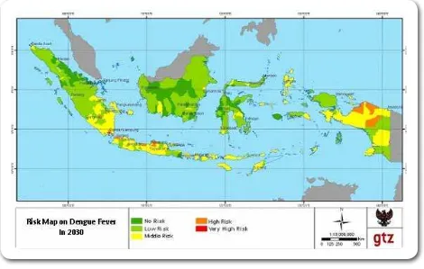
Figure 14 Map of Dengue Fever Risks in 2030 45
Figure 15 Map of Malaria Risks in 2030 45
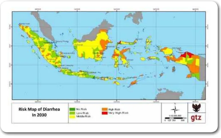
Figure 16 Map of Diarrheal Risk in 2030 46
Figure 17 The “Avoid / Reduce-Shift-Improve” approach 63
Figure 18 Examples of Emission Intensity in Cement Production 70
Figure 19 Cement Industry - Total Estimated Abatement Potential 2008 - 2030 84
Figure 20 GHG Emissions by Sectors in Energy Sector 84
Figure 21 Estimated GHG Emissions from Fossil Fuels 86
Figure 23 Emission Reduction and additional investment in Java-Bali Power System in 2020 based on New Tech and New Tech with NPP scenarios
Figure 24 Emission Reduction and Additional Investment in Java-Bali Power System in 2020
based on carbon value scenarios
Figure 25 Emission Reduction and Additional Investment in Sumatera Power System in 2020
based on carbon value scenarios
Figure 26 Risks of Water Shortage, Drought and Flooding
Figure 27 Risks of Sea Level Rise, Tides, ENSO, and Storm Surge
Figure 28 Inter-connecting Impacts of Climate Change Resulting in Food Scarcity
Figure 29 Location of Hotspots during 1997-1998 Forest Fires
Figure 30 Interconnecting Impacts of Climate Change Resulting in Natural and Built
Environmental Degradation
ICCSR - SYNTHESIS ROADMAP
xiii
99104
105
106
108
109
110
LIST OF ABBREVIATIONS
3R Reduce, Reuse, Recycle
ADT Absolute Dynamic Topography AMI Annual Malaria Incidence ANI Indonesian National Atlas API Annual Parasite Incidence
APBN State Expenditure and Revenue Budget ASEAN Association of South East Asian Nations ASI Indonesian Cement Association
Bappenas National Development Planning Agency
BaU Business as Usual
BMKG Meteorology Climatology and Geophysics Agency
BPOM Food and Drug Monitoring Agency CCS Carbon Capture and Storage CERs Certiied Emission Reductions CFR Case Fatality Rate
CGCM Coupled General Circulation Model
CO2 Carbon Dioxide
CO2e Carbon Dioxide equivalent
EN El Nino
ENSO El Niño Southern Oscillation
ESCO Energy Services Companies
FAO Food and Agriculture Organization
FNC First National Communication GCM General Circulation Model GDP Gross Domestic Product
GHG Greenhouse Gas
GHGe Greenhouse Gas Emissions GoI Government of Indonesia HTI Industrial Plant Forest HTR Community Plant Forest IEA International Energy Agency IFFM Integrated Forest Fire Management
IPCC AR-4 Intergovernmental Panel on Climate Change Assessment Report 4
IR Incidence Rate
JITUT Small Agriculture Level Irrigation Network
KPH Forest Management Units
K/L Ministry/Agency
LN La Nina
LUCF Land Use Change Forestry
MoMF Ministry of Marine and Fisheries MRI Meteorological Research Institute
MtCO2 Million Tons Carbon Dioxide
MW Mega Watt
NAPZA Psychotropic Substances and Addictives
NOAA National Oceanic and Atmospheric Agency
NOx Nitrogen Oxide
NPP Nuclear Power Plant
NPV Nett Present Value
OI Optimum Interpolation
PTT Integrated Crop Management PUSKESMAS Public Health Center
RAN-PI National Action Plan on Climate Change
REDD Reducing Emissions from Deforestation and Degradation RENSTRA Strategic Plan
RENJA Annual Working Plan
RKP/D Government/Regional Work Plan
RPJMN National Medium-Term Development Plan
RPJPN National Long-Term Development Plan
RUPTL Master Plan for Electricity Supply SAT Surface Air Temperature
SC1 Scenario 1
SC2 Scenario 2
SC3 Scenario 3
SC4 Scenario 4
SFM Sustainable Forest Management
SKPD Regional/Local Work Apparatus Unit
SLI Field School of Climate
SLPHT Field School of Integrated Pest Control SL-PTT Field School of Integrated Crop Management
SLR Sea Level Rise
SRA Special Report on Aviation
SRES Special Report on Emission Scenario SST Sea Surface Temperature
TNA Technology Need Assessment
TPA Tempat Pemrosesan Akhir (inal solid waste disposal/landill)
TPS Tempat Pengumpulan Sementara (solid waste collection station)
UNDP United Nations Development Programme
UNFCCC United Nations Framework Convention on Climate Change USD United States (of America) dollars or US$
WP3K Coastal Zones and Small Islands
ICCSR - SYNTHESIS ROADMAP
BACKGROUND
1
ICCSR - SYNTHESIS ROADMAP
Indonesia plays an active role in various international negotiations on climate change, and hosted the
13th Conference of the Parties to the UNFCCC in Bali, which created the Bali Action Plan. With vast
coastline, high susceptibility to natural disasters, and highly vulnerable agriculture production systems, Indonesia is one of the countries that are most vulnerable to the negative impacts of climate change. Thus, Indonesia needs to be at the forefront of collective international efforts to manage the risks of global climate change.
In fact, Indonesia has a dual role in these international efforts. On the one hand, Indonesia is estimated
to be one of the top ten countries in terms of GHG emissions, and thus has an important role in global
GHG mitigation efforts. On the other hand, Indonesia’s extensive vulnerability to the negative impacts of climate change makes adaptation a critical national priority. Aware of both aspects of the climate
challenge, Indonesia recognises that mitigation and adaptation actions have to be taken jointly by all
countries. Therefore Indonesia is ready to cooperate both bilaterally and multilaterally with international
efforts.
Indonesia also recognizes that tackling climate change is an integral part of the development challenge facing the nation. Climate change planning cannot and should not be performed separately from national economic development planning, thus planning for both mitigation and adaptation must be integrated into all aspects of national, regional, and local development planning.
It is expected that the ICCSR serves as a detailed policy guidance and mainstreaming tool for the sectoral and cross-sectoral development programs in order to take up considerations of climate change into all aspects of development planning.
On February 5th 2007 the Indonesian Government issued Law No. 17 of 2007 on the National
Long-Term Development Plan (RPJPN) for Years 2005-2025. The sixth mission statement of this document is:
“To make Indonesia wonderful and preserved by keeping the balance between utilization, sustainability,
existence, and usefulness of natural resources and the environment, by protecting the function, capacity and the comfort of living in the present and the future, through balanced land use for settlement, social economic activities and conservation; augmenting the economic utilization of natural resources and environment sustainably; improving the management of natural resources and the environment to
support the quality of life; providing the wonder and comfort of life; and enhancing the preservation and utilization of biodiversity as basic capital of development”.
In order to achieve this vision of sustainable development, the Government of Indonesia concluded
that “the long term sustainability of development will face the challenges of climate change and global warming which affect activities and livelihood”.
jointly the challenges of mitigation and adaptation to climate change.
In December 2007, Bappenas (the National Development Planning Agency) published a document titled
“National Development Planning: Indonesian Responses to Climate Change”1. The document
is intended to strengthen and reinforce the RPJMN (National Medium-Term Development Plan) 2004-2009 as well as to include inputs that can guide the integration of considerations of climate change into the preparation of RPJMN 2010-2014.
To elaborate further on the documents mentioned above and also to speed up the implementation by various relevant sectors, Bappenas initiated the development of a roadmap to serve as a detailed policy guidance and in order to mainstream climate change issues into national development planning. The
“Indonesia Climate Change Sectoral Roadmap” (ICCSR) will be referred to simply as The Roadmap
throughout this Synthesis Report.
1This document was then revised in July 2008
ICCSR - SYNTHESIS ROADMAP
APPROACH
2
ICCSR - SYNTHESIS ROADMAP
2.1 Goals
Cimate change will create tremendous challenges for sustainable development in Indonesia. To anticipate these challenges the GOI established the Indonesia Climate Change Sectoral Roadmap (ICCSR 2010 - 2030) to set national goals, sectoral targets, milestones and priorities for actions with regards to adaptation
and mitigation of climate change for all affected sectors of the economy.
The ICCSR is meant to provide inputs to the 5 year Medium-term Development Plan (RPJM) 2010-2014, and also to the subsequent RPJMN moving forward until the target year of 2029.
Furthermore, the ICCSR shall serve as detailed policy guidance for further implementation of national adaptation and mitigation responses to climate change through the development of annual government
workplans in the years 2010 – 2020 and in particular to reach the national targets of 26 % and 41 %
reduction in national greenhouse gas emissions, as mandated by the soon established presidential decree.
The ICCSR will guide the following initiatives:
1. a. Advanced research on the impact of climate change and the mapping of local vulnerability will be performed to strengthen the information system for adaptation in 2015.
b. The inventory of CO2 emissions will be reined and the target of emission reduction will be adjusted in 2015.
2. a. With the strengthening of institutional capacity to anticipate climate change impacts among national ministries and agencies by 2015, the goal of climate-prooing national policies and regulations can be achieved by 2020.
b. The ICCSR will serve as policy guidance for decreasing emissions of greenhouse gases from the projected “business-as-usual” emissions scenario in by 26% in 2020, using the nation’s domestic resources and by up to 41% from the business-as-usual scenario if adequate international support becomes available.
3. a. The successful implementation of climate change adaptation and mitigation efforts will help to advance achievement of national development goals by 2025.
b. During this period, alternative sources of energy supply will be signiicantly increased, while the use of non-renewable energy sources will be proportionately reduced.
4. a. The risks of negative climate change impacts on all sectors of development will be
considerably reduced by year 2030 through public awareness-raising, strengthened local capacity, improved knowledge management, and the application of adaptive technology.
b. All sectors that contribute to greenhouse gas emissions will have adopted low-carbon
development strategies and implemented them in ways that advance the prospects for balanced
2.2 ICCSR Scope
The sector classiication used in the Roadmap deviates from the standard approach recommended by the IPCC for the preparation of national communications by non-Annex 1 Parties to the UNFCCC. However, this scope was selected for the ICCSR in order to align the ICCSR effort with Indonesia’s national development priorities and to support the GOI’s perceived sense of urgency in developing
effective responses to the risks of climate change.
The high priority sectors for adaptation actions include the following: water resources sector; marine and isheries sector; agriculture sector; and health sector, while for mitigation, the high priority sectors consist primarily of the forestry sector; energy sector; industry sector; transportation sector; and waste sector. For the purposes of the ICCSR, the Energy Sector was divided into the power generating sector for Java-Bali and Sumatra (the main producers of energy in Indonesia) and the energy demand side of
the industry, and transport sectors.
Inter-sectoral linkages. Following principally from the sectoral classiication of the national development
planning system, the Roadmap process included several activities designed to address inter-sectoral issues
related to climate change. Workshops were held to discuss and analyze linkages between the forest, energy and agriculture sectors as well as the implications of these linkages for national security. Based on the initial indings of these workshops, a follow-up to the Roadmap will be required to address the issues
related to impacts of climate change on biodiversity, energy and food security, population and gender
in Indonesia. Most importantly, the issue of land use deserves greater attention in the future when seen
from an inter-sectoral perspective as land use conversions are planned in the agriculture, forestry and energy sectors, the issue of future GHG emissions must be addressed. These inter-sectoral linkages and
inter-dependencies will be dealt with in the follow-up process to the ICCSR. The way forward will involve
integrated land-use planning that integrates consideration of climate change issues, increased institutional
capacities, and enhanced enforcement mechanisms for national laws and regulations.
Regional scope. The Roadmap recognizes that, because of its diversity along physical, economic,
political, and cultural dimensions, Indonesia requires region-speciic approaches to national development
planning. The proposed policy responses to climate change that are outlined in this ICCSR have been
tailored to the speciic characteristics of Indonesia’s main regions: Sumatra, Jamali (Java, Madura, Bali), Kalimantan, Sulawesi, Nusa Tenggara, Maluku, and Papua.
ICCSR - SYNTHESIS ROADMAP
2.3 Linkages between Climate Change Roadmap and Development Planning: approach and methodology
To ensure involvement and ownership of the Roadmap by the relevant ministries and agencies of the
GoI, the development of the Roadmap has been carried out through a participatory approach involving three parties; the National Development Planning Agency (Bappenas), the individual ministries and
agencies, plus the Technical Team. As a consequence, the priority activities highlighted in the Roadmap relect the vision and priorities of each ministry and agency. Bappenas has acted primarily as a facilitator
of the analytic and policy development processes.
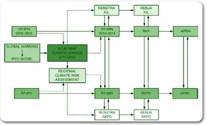
The inter-linkages between the Climate Change Sectoral Roadmap and the National Development
PlanningProcessare illustrated in Figure 1 below:
Figure 1: Inter-linkages between the Climate Change Roadmap
and Development Planning
The ICCSR team has applied a risk assessment framework, beginning with the identiication of climate hazards, to guide the formulation of adaptation strategies in the priority sectors. This process begins with
the development of regional climate change projections, including future projections of temperature, rainfall, sea level rise, and the occurrence of extreme events. The impact of climate change on each of the
priority sectors (Figure 2) is then analyzed. Priority activities for adaptation have been formulated based
Meanwhile, the formulation of priorities for GHG mitigation is based on the study of current emissions
levels (National Greenhouse Gas Inventory2) and the emission reduction scenarios developed for each
sector (e.g., energy, transportation, industries, forestry, and waste). In order to ensure comparability
and consistency, a standardized methodology was used to evaluate the impact of candidate mitigation activities in all priority sectors. That methodology included the following elements:
2The national GHG emissions baseline still needs to be formulated for Indonesia; for the ICCSR, sectoral baselines were already
formulated. It will be adjusted to the extent possible so as to relect future guidance provided to Parties by the UNFCCC, including the international requirements and standards expected for monitoring, reporting and veriication (MRV), which are still in the process of be -ing negotiated in the UNFCCC.
ICCSR - SYNTHESIS ROADMAP
9
1. Indonesia’s Second National Communication to the UNFCCC was used to harmonize the
estimates of greenhouse gas emissions in all sectors.
2. A range of scenarios were created to cover the 20-year time period of the roadmap. The likely patterns of development in each sector were translated into a set of emissions trajectories (e.g., scenarios of power supply development in Java-Bali/Sumatra system, including the optimal power supply mix under different constraints);
3. Mitigation scenarios were developed, including policy interventions, technologies, and actions;
4. The scenarios were divided in 2 periods of ten years each: 2010 until 2020, 2020 to 2030;
5. The costs of the relevant actions were assessed, resulting in an estimate of system abatement
costs;
6. The cumulative emissions reductions were calculated in TCO2e;
7. Scenarios were selected that were considered to be the most likely to reduce emissions (including technology mix, policies and actions) while advancing national development priorities;
8. The scenarios were used as input to discussions with each of the sector teams and an agreement was reached on the preferred approach;
9. The outcomes of these discussions were incorporated into the Mitigation Matrix; and
10. Sectoral programs and budgets were established to relect both the scenarios and the appropriate
response measures.
2.4 Sectoral activity categories
As a nationally concerted effort to cope with climate change, the Indonesia Climate Change Sectoral Roadmap sets up three categories of activities in each development sector as follows:
Category 1. Data, Information and Knowledge Management (KNOW-MANAGE)
This category consists of activities related to data collection, information development and knowledge
management concerning the impacts of climate change and the GHG emissions from each sector that
need to be mitigated. This is to be achieved through scientiic research, based on collaboration between
universities, research institutions and the government.
Category 2. Planning and Policy, Regulation and Institutional Development (PLAN-PRIDE)
development and institutional strengthening measures. These programs are designed to develop plans,
policies, regulations, and new institutional development, all of which will support the implementation of
adaptation and mitigation actions.
Category 3. Implementation and Control of Plans and Programs with Monitoring and Evaluation (ICON-MONEV)
This category consists of activities to implement plans for adaptation and mitigation of climate change. In addition, monitoring and evaluation measures are embedded in the actions included in this category in
order to ensure effective implementation of the activities formulated in Category 2 above.
In order to allocate national resources eficiently and effectively toward several goals over the next 20 years, each category has a different programming strategy. The principle strategies are as follows:
1. During the irst period of implementation of the National Medium-Term Development Plan (RPJMN) 2010-2014, funding is concentrated on activities in Category 1. Consequently, activities which are included in Category 2 and 3 receive a smaller portion of the available budget. This
strategy aims to strengthen institutional capacity in the areas of data and information management, climate risk assessment, and greenhouse gas inventory development. The precise proportions of
funding available in each category will depend on the capacity of each sector to respond to climate
change. Sectors that have already prepared for climate change impacts may set up more advanced programs and activities; these sectors may receive disproportionately greater funding.
2. During the later period, each sector will focus increasingly on activities that are classiied in Category 2 and Category 3. The ICCSR posits that each sector will focus more on activities in Category 3 (Adaptation and Mitigation Action) beginning in the period of 2020-2025.
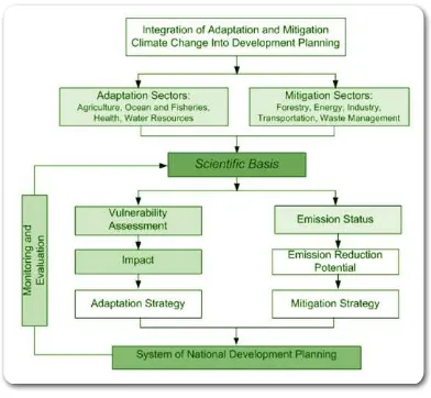
The National Roadmap for mainstreaming climate change into development planning can be summarized
as illustrated in the diagram below. Activities for adaptation and mitigation are proposed in each sector, representing the elaboration of activities in the three categories described above. Figure 3 below illustrates
the process.
Figure 3 Chart of National Roadmap for Climate Change Adaptation and Mitigation
ICCSR - SYNTHESIS ROADMAP
2.5 Connection of ICCSR with related climate change initiatives
Relationships among the ICCSR, the Presidential Decree, and the Action plan to reduce GHG
emissions. The ICCSR provides detailed guidance that can aid both the national and local governments,
national in their efforts to integrate emissions mitigation actions into their annual and strategic workplans,
advancing national development priorities as they prepare measures to reach the targets of reducing
GHG emissions by 26 and 41% respectively.
During 2010 – 2011, the GOI will undertake mainstreaming exercises at provincial levels, which should generate further guidance for the formulation of actions at local levels that will reinforce efforts to meet
the national target of reducing GHG emissions.
Linkages of ICCSR with the Indonesia Climate Change Trust Fund. To facilitate inancial support
for actions needed to respond to the risks of future climate change, the GOI has developed a national trust fund mechanism called the Indonesian Climate Change Trust Fund (ICCTF). The ICCTF will serve as a key inancial mechanism through which the government, private sector and civil society groups can contribute to national and international efforts to advance development while reducing future emissions of greenhouse gases. It will be one of several inancing mechanisms for national policies and programs and will take guidance on implementation issues from the ICCSR.
IDENTIFICATION OF
CLIMATE CHANGE
HAZARDS IN
INDONESIA
3
ICCSR - SYNTHESIS ROADMAP
3.1 Surface Air Temperature Increase and Precipitation Change
The increase of Surface Air Temperature (SAT) is seen as the main climate change issue as it is attributable to the
anthropogenic driven increase of CO2 and other greenhouse gas emissions. Observed monthly SAT in Indonesia over a period of 100 years shows that a certain degree of climate change has occurred in Indonesia. The data that have been collected from a limited number of stations suggest that a temperature increase of around 0.5ºC has occurred during the 20th century. This magnitude of temperature increase is in agreement with the rate of average
global temperature increase as estimated in IPCC AR-4, which is about 0.7ºC ± 0.2 per century.
Based on the analysis of Global Circulation Model (GCM) output, projected average temperature increase in Indonesia
is between 0.8º - 1ºC for the period of 2020-2050, relative to the baseline period of 1961-1990. The differences in projected SAT between Special Report on Emission Scenario (SRES) B1, A1B, and A23 are not signiicant for 2030,
but become more distinct for the period of 2070-2100. The temperature increase in the Java-Bali region are projected to reach 2ºC, 2.5ºC, and 3ºC for B1, A1B, and A2 scenarios respectively. There are higher probabilities for higher temperature increase in Kalimantan and Sulawesi, but the largest temperature increase of around 4ºC will likely occur in Sumatra. The trend of temperature increase is generally different for each month by 0-2ºC.
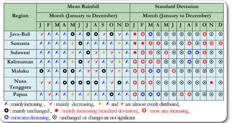
Different from the projected temperature increase, the projected precipitation pattern has more signiicant
temporal and spatial variation. For Indonesian rainfall, in general it is important to note that the trend of rainfall
change may be quite different, not only seasonally but also from month to month. Based on analysis of observed rainfall patterns in Jakarta for example, there has been an increase of around 100 mm January rainfall of 1955-1985 (1970s) compared to that of 1885-1915 (1900s).4 Other results indicate that the rainfall over central and
northern parts of Sumatra has been increasing by 10-50 mm over recent decades compared to that of 1960-1990.
Rainfall change projections based on observational data analysis indicate that there will not be signiicant changes from the recent (period of 1981-2010, but the available data only until 2007) mean annual precipitation over the Java-Bali region for the period of 2010 to 2015. However, projected rainfall of the 1990 to 2020 period shows more signiicant increases in the rainfall of the December-January-February-March period over large regions. Also, with larger variability, rainfall over Sumatra and Papua is expected to increase for almost all seasons until 2020. On the other hand, rainfall is projected to decrease during the July-August-September periods for regions like Java-Bali, Sulawesi, Kalimantan, and Maluku. This
implies that the magnitude of changes in rainfall pattern, relative to recent decades, are expected to be
more signiicant during the period of 2015-2020, compared to that of 2010-2015. A rough summary of
results from the trend analysis are shown in Table 1
3 SRES scenarios are global emission scenarios used in the IPCC climate projections. B1, A1B, and A2 are three of six SRES illustrative
scenario groups. In practice, these scenarios differ in the stabilization of CO2 concentration by 2100 i.e 550 ppm (low), 750 ppm (mod
-erate), and unstabilized (high) for B1, A1B, and A2 scenarios respectively.
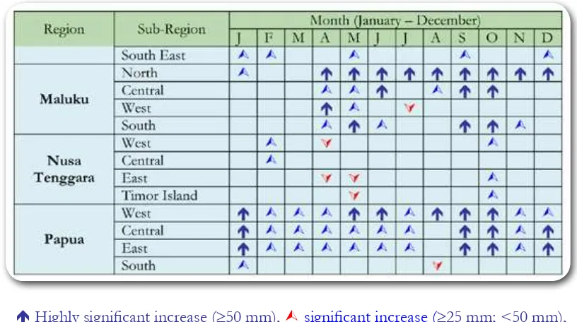
Table 1 Projected rainfall changes (mean and standard deviation) in Indonesia during the period of 2010-2020 (relative to 1980-2007 period), based on polynomial trend analysis of observational data
Results from GCM output do not show signiicant change in the rainfall pattern during the period of 2020-2050. However, large changes can be found in the projected rainfall of the 2070-2100 period, especially for higher CO2 emission scenario (SRES A2). The results of this projection are summarized in the following table (Table 2):
Table 2 Trend of rainfall change in Indonesia based on GCM data with A2 scenario 2070-2100
ICCSR - SYNTHESIS ROADMAP
3.2 Sea Surface Temperature Rise, Sea Level Rise and Extreme Climatic Events
Sea Surface Temperature (SST) rise is a direct consequence of surface air temperature increase. The average SST in Indonesian sea waters is projected to increase by as much as 0.65°C in 2030, 1.10°C in 2050, 1.70°C in 2080, and 2.15°C in 2100 (based on trend analysis from historical data). One of the immediate impacts of SST increase is a depletion and movement of ishing stocks away from Indonesian waters.
Sea Level Rise (SLR) is another important climate change issue. It is brought about by the melting of
ice and glaciers at the poles, and by the thermal expansion of sea water. SLR for Indonesia has been projected from observed satellite altimeter and tidal data, as well as from GCM output. An average SLR of 0.6 cm/year to 0.8 cm/year has been estimated from the output of four GCMs i.e.MRI, CCCMA
CGCM 3.2, Miroc 3.2 and NASA GISS ER, and more complete results are summarized in Table 3.
Table 3 Sea Level Rise Projection since 2000
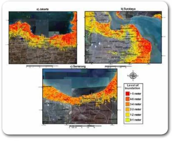
With thousands of islands and a vast coastline, Indonesia is expected to suffer from the severe and drastic impacts of SLR. Many large cities such as Jakarta, Semarang, and Surabaya are expected to suffer from looding and inundation. During extreme weather conditions, extreme waves with heights of 2-3 meters can be triggered. Figure 4 below are future inundation projections for three major cities in Indonesia, based on the pessimistic scenario for 2100.
Figure 4 Projected Sea Level Rise in Jakarta, Surabaya and Semarang in 2100
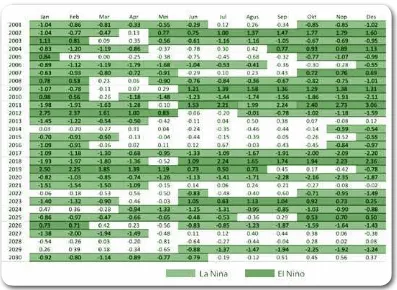
Changing ocean environmental condition will also affect climate variability. For example, the projected frequency of ENSO events, El Niño and La Niña, is expected to increase from its current of 3 to 7 years interval to happening every 2 to 3 years. El Niño and La Niña phenomena are well known to have impacts on rainfall variation in Indonesia but they also affect sea level and ocean weather by inducing more extreme waves. The occurrence of El Niño and La Niña is believed to induce wave height variations in the order of 2 to 5 meters. More complete projections of El Niño and La Niña occurrences in the future are shown in the following table (Table 4):
ICCSR - SYNTHESIS ROADMAP
ADAPTATION IN THE
WATER SECTOR
4
ICCSR - SYNTHESIS ROADMAP
4.1 Current Condition and Projection of Water Sector
4.1.1 Water Shortage
The projected climate change in Indonesia will likely impose stress on water resources. At present, the Java-Bali regions have already faced a deicit in its water balance, while for other regions like Sumatra, Sulawesi,
Nusa Tenggara, and the Moluccas are projected in critical conditions. Based on climate projections, most
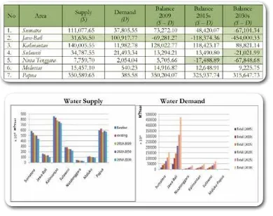
regions in Indonesia will suffer from a gradual decrease of water supply due to temperature increase and rainfall changes that will affect the water balance as illustrated in the table below (Table 5). Combined with estimated population growth rates, increased water demand will cause severe water shortages to occur, especially in Java and Sumatra for the period of 2020-2030.
Table 5 Indonesia’s current (2009) and projection of Water Balance (2015 and 2030) (M3/Year)
A risk analysis for projected water shortages has also been carried out under the framework of this study. Based on this risk analysis, the roadmap deines areas that have high risk or extremely high risk condition which need further attention for adaptation responses. For water sector, the priority areas are as follows (see Figure 5):
1. Extremely High Risk is likely for parts of the Java-Bali region,especially in a few locations in the
2. High risk is observed in about 75% of the Java region, in large parts in the southern of Bali, in a
small part of the northern, western, and southern of Sumatera region, part of the Lombok Island (Nusa Tenggara Barat) and South Sulawesi
Figure 5 Risk Map on Water Shortage using IPCC’s SRA2 Scenario 2025-2030
4.1.2 Flood
Another impact of climate change on water sector is the increase of risk to looding. Almost all parts of Indonesia are vulnerable to lood hazards. According to the Indonesian National Atlas (Bakosurtanal, 2008), Sumatra and Java-Bali have the largest vulnerable areas. Factors contributing to looding are: the extreme rainfall of up to 400/mm/month (as per BMKG); overloaded run off in water shed, such as
rivers, ponds, dams, etc; land characteristics and conditions in the upper of the catchment area. In some
cases, loods are related to landslides5, as happened in Sinjai, Southern Sulawesi, in July 2006, causing
hundreds of casualties. In some area, especially in urban area with high population and development activities, i.e. in Jakarta and Bandung, lood is also generated by land subsidence due to groundwater
overpumping and groundsurface overburden6. Based on the analysis of lood risk, the areas which are
classiied as extremely high and high risks are as follows:
1. ExtremelyHigh Risk of loodingisprojected especially for areas along major rivers, particularly
in downstream areas of Java, Eastern Sumatra; most parts of Western, Southern, and Eastern Kalimantan, Eastern Sulawesi and Southern Papua;
2. Areas which will face High Risk are concurrenceto those with extremely high risk mentioned
5 (Indonesian: banjir bandang) 6 (Indonesian: banjir genangan)
ICCSR - SYNTHESIS ROADMAP
above.
Figure 6 Risk Map on Flood based on Scenario SRA2 in 2025-2030
4.1.3 Drought
Drought has become increasingly frequent phenomenon in Indonesia during the dry season. There is increased threat of drought hazard during periods when mean rainfall (CH) is below normal and temperature increases. The hazard intensity of drought tends to increase from the period of 2010-2015 to 2025-2030; with distribution of affected area as shown in Figure 7. Drought risk is signiicant for the Java-Bali region, most areas in northern Sumatera, part of Nusa Tenggara and South Sulawesi.Drought
makes it dificult for people to ind freshwater, reduces surface water in reservoirs; and limits the yield
of crops, particularly rice. Many agricultural areas in Indonesia are vulnerable to planting and harvesting failure due to drought onset or to shifting of the dry season period.
Findings from the drought risk analysis are as follows:
1. Extremely High risk areas are stretched out over small areas of the Central Java, Northern
Sumatra, and Nusa Tenggara;
2. High risk areas are foundin large parts of Central Java, Sumatra, and Nusa Tenggara, small part of
4.2 Issues and Strategies of Water Sector
As a result of the risk analysis, the following issues have to be addressed in order to successfully adapt the water sector to climate change:
1. The need to maintain the balance between water availability and water demand (water balance);
2. Insuficiency of water infrastructure and the need for provision of alternative water sources in
certain areas;
3. Limited availability of data, technology and research as a basis for water resource management;
4. The necessity to reduce vulnerability and risk from water shortage, lood and drought;
5. The need to ind synergetic solutions for cross-sector issues with agriculture, forestry, health,
energy, and industry sectors;
6. The need to integrate water resources management and lood control;
ICCSR - SYNTHESIS ROADMAP
23
29
7. The need to conserve water based on innovation, community participation and local wisdom.
When addressing these key issues, the water supply and water demand for domestic, urban and industrial use have to be balanced. In order to ensure this, the following strategies should be pursued:
1. Prioritizing water demand for domestic use, especially in regions with water scarcity and in re
gions of strategic importance;
2. Controlling the use of groundwater and enhancing the use of surface water for water supply;
3. Intensifying the development of water storages for water supply and optimization and mainte
nance of existing resources;
4. Encouraging involvement of the private sector for inancing the development of water infra
structure.
5. Acceleration and completion of implementing regulations of the Law No. 7 of 2004;
6. Capacity Building of institutions involved in water resource management to communicate, coop
erate, and coordinate;
7. Community empowerment and participation at local level in water resource management;
8. Partnership between government and community in water resource management.
4.3 Activities of Water Sector
From many activities that had been discussed during several focus group discussions and stakeholder
prog
ram for 5 years (2010-2014) is estimated as m
uc
h as IDR 14.7 trillion (LPEM UI, 2009).
Category Activities 2010-2014 2015-2019 2020-2024 2025-2029
Data,
Focus area: BBWS Sumatera I and Mesuji Sekampung in Sumatera, BBWS
Bengawan Solo and Pemali Juwana in Java, BWS Kalimantan II in Kalimantan,
BBWS Pompengan Jenebarang in Sulawesi, BWS Nusa Tenggara I in Nusa Tenggara, BWS Maluku, and BWS
Papua.
Focus area: BBWS Brantas and Ciliwung-Cisedane; BBWS
Sumatera II dan V; BWS Kalimantan III; BWS Sulawesi II; BWS Nusatenggara II; Maluku and
Papua
Focus area: BBWS Serayu-Opak, Cimanuk-Cisanggarung
Revitalization of local wisdom and building the capacity and participation of community in adapting
to climate change
Focus area: SWS Musi in Sumatera, WS Citarum, Ciliwung and Citanduy in
West Java and Jakarta, WS Mahakam in Kalimantan, and SWS Jeneberang in
Sulawesi.
Focus area: WS Bengawan Solo, Pemali, Comal; SWS Krueng; WS
Kapuas
Focus area: WS Brantas; SWS Batangharileko; WS Barito;
and Tondano
Focus area: WS Opak; SWS Mesuji;
WS Kahayan; and North Sulawesi
Enhancement of water conservation and reduction of hazard and disaster related to climate
change
Focus area: West Sumatera Province, Banten and West Java Province, West Kalimantan Province, Gorontalo Province, East Nusa Tenggara Province,
Maluku Province, and West Papua Province.
Focus area: Central Java; Bengkulu; South Kalimantan; East Sulawesi;
West Nusatenggara
Focus area: DI Yogyakarta; Lampung; Central
Enlargement of water supply using appropriate
technology and development of local
water resources
Focus area: BBWS Sumatera VIII in Sumatera, and BWS Kalimantan II in Kalimantan; Papua: BWS Western Papua
Focus area: BWS Kalimantan III; BWS Northern Papua
Focus area: BWS Kalimantan
I; BWS Southern Papua TBD
Focus area: construction of dams in Deli Serdang, North Sumatera, in Ponorogo, East Java, in Wajo, South Sulawesi, and in
East Lombok, West Nusa Tenggara
TBD TBD TBD
Table 6 Priority Activities of Water Sector
ICCSR -
SYNTHESIS ROADMAP
ADAPTATION IN THE
MARINE AND
FISHERIES SECTOR
5
ICCSR - SYNTHESIS ROADMAP
5.1 Current Condition and Projection of Marine and Fisheries Sector 5.1.1 Coastal Inundation
Indonesia is an archipelagic country consisting of 17,480 islands with total coastline of 95,181 km. Coastal inundation due to SLR will cause serious problems along coastal zones where a large part of population (about 50-60% of total) resides. Signiicant infrastructure and economic assets are located in these areas. As an example, there are about 968 ishery ports that have been built without considering
SLR projection. Many important tourist destination and attractions, both natural and man-made, lie in
coastal areas. The estimated average rate of SLR in Indonesia is around 0.6 cm/year. Based on available SLR scenarios by considering ENSO, storm surges, and highest tides, maps of inundated area have been developed as seen in Figure 8 for Java-Bali region. Meanwhile, the projection of the size of inundated areas in each region in Indonesia for the year 2030 is illustrated in Figure 9.
Figure 8 Simulation of Coastal Inundation in Java-Madura-Bali
Figure 9 Projection of Inundation Area in 2030
24286.82
1932.86 7024.23
7641.90
4275.45 4318.81 14468.29
Nusa Tenggara Jawa Bali Kalimantan Maluku Sulawesi Papua Sumatera
5.1.2 Sea Surface Temperature (SST)
Based on National Oceanic and Atmospheric Agency (NOAA) optimum interpolation (OI) data from 1983 to 2008, the average of SST trend over the Indonesian Seas is 0.65oC + 0.05oC in 2030. Coral reefs
are very vulnerable towards abrupt change of temperatures. Temperature increase of 1oC to 2oC from
long-term average will also cause coral bleaching.
Indonesia also possesses the largest area of coral reef in the world, with an area reaching 60,000 km2
which is around 18% of the world’s coral reef. According to the Directorate General of Coastal and Small Islands, Ministry of Marine and Fishery Affairs (DKP, 2005), the current condition of Indonesia’s reefs is as follows: damaged (42.78%), moderate (28.30%), preserved (23.72%). However, the reefs which are still considered to be in pristine condition are only 6.20% of the total. In the meantime, the warmer SST may shift ishing grounds from tropical area to the sub-tropical regions with a lower temperature.
Figure 10 Sea Surface Temperature Increase Based on SRES A1B Using MRI_CGCM 3.2 Model
5.1.3 Extreme Events
Many oceanographers argue that global warming has a strong relationship with a higher frequency of extreme event, such as El Niño and La Niña (Timmermann et. al., 1999 and Timmerman, 2000). Generally, El Niño and La Niña occur once every 3-7 years, but since 1970, the frequency of El Niño and La Niña increases to once every 2-6 years (Torrence and Compo, 1999). La Nina could also heighten wave height by around 20 cm. Additionally, rising SST will lead to an increase of extreme weather events (storms, cyclone). According to Saunders and Lea (2008), an increase in Sea Surface Temperature by 0.5ºC is correlated with an increase of hurricanes by as much as 40%. Although very few tropical cyclones hit land
ICCSR - SYNTHESIS ROADMAP
areas in Indonesia, extreme marine weather events that occur in the southern parts of Indonesia (during the rainy season), and the northern parts of Indonesia (during the dry season), may cause signiicant impact (in the form of massive high waves and storm surges) to vulnerable coastal areas.
5.2 Issues and Strategies of Marine and Fisheries Sector
Several issues that were initially identiied in the marine and isheries sector from the risk analysis are:
1. Existing regulation and policy have not speciied the need for climate change adaptation;
2. Inundation of settlements, business areas, ishponds, and ports because of SLR and damage
caused by storms have not been considered by policy makers at national and local government;
3. Shifting of ishing grounds, depletion of ishing stocks, and the changing pattern of winds will
bring severe damages;
4. Degrading and sinking of outer small islands (Indonesia’s territory border).
The strategies for Roadmap of climate change adaptation in marine and ishery sector are as follows:
1. Physical adaptation in coastal zones and small islands by an integrated management and
environmentally sound physical engineering;
2. Settlement management;
3. Infrastructure and public facility management;
4. Resource management of isheries, water resources and defense and security (outer small islands);
5. Integrated management of coastal zones, small islands and marine ecosystems;
6. Formulation of regulations, policies, and institutional capacities;
5.3 Activities of Marine and Fisheries Sector
Several activities to anticipate hazards brought by intensiied climate change were discussed in several focus group discussions with stakeholders from the marine and isheries sector and illustrated in the table below (Table 7).
Among those activities, there are ive champion activities recommended for the marine and isheries sector based on current and projected conditions as follows:
1. Activities of formulation or adjustment of regulation, policy and institutional capacity of the marine and ishery sector to adapt to climate change in coastal areas and small islands consists:
• Formulating norms, standards, guidelines, and criteria for climate change adaptation and mitiga tion;
• Adjustment of regulation and policy related to climate change;
• Acceleration of the issuance of local government decision on Strategic Plan of Coastal Zone
And Small Islands (WP3K) that has incorporated climate change issues and a risk map.
2. Activities of “Elevation adjustment and strengthening of buildings and vital facilities on coastal areas prone to climate change” consists of these activities:
• Identiication of existing and projected condition of all infrastructure and vital facilities in the
coastal areas;
• Elevation adjustment and strengthening of building and vital facilities;
• Study on elevated house construction and its dissemination;
• Construction and maintenance of beach protection structures.
3. The adjustment of integrated captured ishery management activities consists of:
• Development and dissemination of information system, and mapping of the dynamic ishing
ground;
• Development and dissemination of real-time weather information system on ocean;
• Capacity building of ishermen in order to reach distance, off-shore ishing grounds;
• Development and improvement of stock/logistic management, using cold storage.
ICCSR - SYNTHESIS ROADMAP
4. Adjustment of cultured ishery management activities that includes saltwater, brackish water and freshwater ish farms consists of:
• Development of ish breeds that are resilient to climate change;
• Expansion and improvement of existing ishponds and their water channels;
• Development and improvement of ish market depots as part of stock management;
• Development of cultured ishery on wetlands.
5. Adjustment of the management of strategic small islands consists of :
• Identiication of current and projected conditions of strategic small islands including the
remote islands on the Indonesian border;
• Construction and maintenance of beach protection structure and navigation safety facilities;