Jomoro
Tamale
Burkina FAso
T
ogo
Iv
o
r
y C
o
a
st
Accra
Takoradi
Kumasi
Integrated Coastal and Fisheries Governance Initiative
This publication is available electronically on the Coastal Resources Center’s website at http://www.crc.uri.edu.
For more information contact:
Please cite this report as:
Coastal Resources Center (2013). Jomoro District Integrated Coastal Management Toolkit. Integrated Coastal and Fisheries Governance Initiative (Hen Mpoano) Narragansett, RI: Coastal Resources Center at the Graduate School of Oceanography, University of Rhode Island 61 pp
Disclaimer:
This publication is made possible by the generous support of the American people through the United States Agency for International Development (USAID)/Ghana. The contents are the responsibility of the authors as part of the Integrated Coastal and Fisheries Governance (ICFG) Initiative and do not
necessarily relect the views of the United States Government. Associate Cooperative Agreement No.
641-A-00-09-00036-00 for “Integrated Coastal and Fisheries Governance (ICFG) Program for the Western Region of Ghana,” Under the Leader with Associates Award No. EPP-A-00-04-00014-00.
Cover photo: Nzulezo, Jomoro District Photo credit: Lucia Rybarova
Coastal Resources Center
University of Rhode Island, Narragansett Bay Campus 220 South Ferry Road
Narragansett, Rhode Island 02882 USA
Brian Crawford, Director of International Programs Email: [email protected] Tel: 401-874-6224 Fax: 401-874-6920
Friends of the Nation
http://www.fonghana.org [email protected]
P.O Box MC 11
Takoradi, Western Region, Ghana
Hen Mpoano
http://www.henmpoano.org P.O. Box AX 296
Takoradi Western Region Ghana
Acknowledgements
With funding from the United States Agency for International Development (USAID), the Coastal Resources Center of the Graduate School of Oceanography at the University of Rhode Island have worked together with core partners
including Friends of the Nation, Worldish and Sustainametrix to implement the
Integrated Coastal and Fisheries Governance (ICFG) Initiative, locally known as Hen Mpoano. We are pleased to compile a compendium of Integrated Coastal Management (ICM) information and knowledge generated through this 4-year Initiative into a toolkit to inform district level planning and management of
coastal and marine resources. Compilation of this material beneited from the
contributions of a large number of colleagues and practitioners, including many members of the coastal communities of the Western Region of Ghana and beyond, who have assisted in information gathering, research and analysis. We sincerely acknowledge the contribution of the planning departments of the six coastal districts of the Western region in supporting the development of innovative processes that builds ICM into district planning processes and decision making procedures. We are also grateful to the following individuals for providing technical insights and guidance during the production of this material: Dr. Christopher Cripps (Spatial Solutions), Dr. Donald Robadue (Coastal Resources Center, University of Rhode Island, USA), Stephen Kankam (Hen Mpoano), Pamela Rubinoff (Coastal Resources Center, University of Rhode Island, USA), Hillary Stevens (Coastal Resources Center, University of Rhode
Island, USA) and Koi Agbogah (Hen Mpoano). The graphic designs and layouts
as well as GIS mapping have been done through the hard work of Justice Camilus Mensah (Hen Mpoano) and Lucia Rybarova (Oil City Magazine).
Finally, we would like to acknowledge the fruitful collaboration developed with
key oficials and institutions, without which this toolkit will not have been
possible. At the regional level the partnership developed with the Members,
Chief Executives, Directors and Oficers of the District Assemblies, Regional
Coordinating Council and private companies is appreciated. At the national level, our collaboration with the National Development Planning Commission, Fisheries Commission, Town and Country Planning Department, Ministry of Environment, Science, Technology and Innovation is acknowledged. It is our hope that this toolkit and the legacy of the Hen Mpoano Initiative will inspire further work in coastal and marine management in Ghana.
3
Statement from Honourable
Sylvester Daddieh, District
Chief Executive of the Jomoro
District Assembly
This toolkit is very unique and presents an
opportunity for our district to have a foretaste of coastal management. I appreciate the efforts of Hen Mpoano for carefully putting together a resourceful tool like this as guidance for coastal planning and decision making in our district.
In its four years of operation, Coastal Resources Center and partners under the Hen Mpoano Initiative have assisted to build on our knowledge and views - as district planners and managers - of what the coastal zone is really about. The Initiative has assisted the district to identify major coastal zone challenges and given the people the requisite capability meant to advance conservation and sustainable development of the district’s rich coastal resources.
This Toolkit has put together their indings and
evidence gathered from 2009-2013, summarises the tools that have been developed during that time for all of us to tackle the problems and grasp the opportunities that exist. It tells us how to counter and avoid all the potentially destructive and harmful challenges which are being faced, and shows how the coast may become a place of pride, or harmony, of abundance based on the rich resources that have been enjoyed by its peoples for centuries past, while welcoming the incredible technologies of the 21st century which are now well among us.
I strongly recommend this toolkit to all who are living, working and investing in our coast.
CHIEF EXECUTIVE,
lood and drought), causing
sea levels also to rise.
Community Resourced Management Areas (CREMA): creates a win-win situation by creating a
inancial incentive for farmers
to use and manage natural resources on sustainable basis by devolving management rights and responsibilities to them.
Development: is any man-made alteration to the landscape including grading,
illing, dredging, extraction,
storage, subdivision of land, or construction of structures, stormwater collection, drainage and discharge
works, lood protection
works.
Ecosystem: a complex set of relationships among the living resources, habitats and residents of an area. It includes plants, trees,
animals, birds, ish,
micro-organisms, water, soil and people. Everything that lives in an ecosystem is dependent on the other species and elements that are part of that ecological community.
Eco Tourism: is a a form of tourism involving visiting fragile, pristine, and relatively undisturbed natural areas, intended as a low-impact and often small scale alternative to standard commercial (mass) Adaptive Capacity: capacity
of a community to adapt itself to the threats and hazards such as climate change, coastal erosion, loss of livelihoods and inappropriate development.
Artisanal Fishing leet:
traditional canoe-based
ishing vessels.
Barrier spit or beach: sandy beaches built up by ocean wave energy and backed by wetlands or river
outlows. These systems are
in constant movement in response to the energy of the surrounding system.
Built Areas Highly
Exposed to Flood Damage: are settlements, businesses, residences and public
buildings which are routinely
submerged by lood waters,
erosion or damage from high velocity stream and drainage
low.
Carbon Sequestration: the absorption of carbon dioxide (a “greenhouse gas” which is responsible for global warming) by vegetation.
Catchment Area The area receiving the waters feeding a part or the totality of a watercourse or watershed.
Climate Change: the changes in climate which are being experienced, including extremes of weather (storms,
Definitions
tourism. Its purpose may be to educate the traveler, to provide funds for ecological conservation, to directly
beneit the economic
development and political empowerment of local communities, or to foster respect for different cultures and for human rights. Ecological goods and services: are the beneits provided by wetlands e.g.,
water puriication, supplies of portable water, ishes,
plants, building materials and water for livestock, outdoor recreation and education.
Environmental
Assessment: is the process of identifying, predicting, evaluating and mitigating the biophysical, social, and other relevant effects of development proposals prior to major decisions being taken and commitments made.
Erosion: is the removal and transportation of soil particles by the action of water, wind, gravity or other geographical agents, whether naturally occurring or acting in conjunction with or promoted by man - made activities or effects.
Estuary: means a body of surface water a) that is part of a water course that permanently or periodically opens to the sea b) in which the salinity is measurably
higher as a result of the
inluence of the sea.
Flood: an overlow of rain water or other sources along
the normal conines of a
river, stream, drainage way or other water body that causes or threatens damage to property, infrastructure, people, or natural resources.
Flood prooing or
protection: means any combination of structural and non-structural additions, changes, or adjustments to existing or new structures which reduce or eliminate
lood damage to residential
and non-residential buildings and their contents. These can include protective walls and drainage systems to redirect water away from existing buildings, rebuilding structures to make them more resistant to the
intrusion of lood waters
or the physical force of high velocity water. It also includes special design and construction techniques including piers and elevating
the lowest usable loor of a
building above the level of water experienced in events.
Floodplain: a level or nearly level land along a
stream or river looded only when the stream low
exceeds the water carrying
capacity of the channel. lat or nearly lat land adjacent
to a stream or river that
experiences occasional or
periodic looding.
Green Belt: an area which has been designated around a settlement for no development in order to provide access to green and open spaces and to encourage more dense urbanization.
High tide line: is the highest point on the shore that is covered by water at high tide. Ghana has two high tides and two low tides each day. The mean tidal range (distance between high and low tides) is 1 meter, and the spring tidal range (time of new or full moon) is 1.3m. For purposes of coastal development, this is the line which development is set back from.
Lagoon: closed or open, a shallow body of water separated from the ocean by a barrier island or spit. It may be open to the ocean occasionally during seasonal
looding or high seas.
Pair Trawling: the joining of nets to two boats in order to increase catches.
Pocket beach: a short sandy shoreline between rocky headlands that prevent long shore transport of sediment.
Restoration: is a broad process of reversing physical, economic and social decline in a coastal area.
Set back: is an area left free of any physical development
or modiication, commonly
used to setback structures from a coastal feature, or from a road in an urban area.
Shoreline protection structures, or sea defense structures:
include breakwaters, groins, bulkheads, jetties, and other structures, the purpose or effect of which is to control or prevent the erosion of coastal features.
Traditional Authorities: the traditional governance system of chieftaincy in Ghana.
Watershed: area of land where all of the water that is under it or drains off of it goes into the same place, such as a river or a wetland.
Water dependent uses: are uses that can only be conducted on, in, over, or adjacent to the water; each involves, as an integral part of the use, direct access to and use of the water. These uses cannot physically function without direct access to the body of water along which it is
7
Jomoro ICM Toolkit 2013
INTRODUCTION
Hen Mpoano and Jomoro District Collaboration
This Toolkit is the inal output, for Jomoro District, of the Integrated Coastal and Fisheries Governance
(ICFG) initiative, which has become locally referred to as HεN MPOANO (Our Coast). It is a four-year
project carried out by the University of Rhode Island Coastal Resources Centre and partners (see acknowledgments),and funded by the United States Agency for International Development (USAID).
The Overall Goal of the Hen Mpoano Initiative
Overall Goal: to support the Government of Ghana in achieving its development objectives of poverty
reduction, food security, sustainable isheries management and biodiversity conservation.
The initiative’s vision is that:
Ghana’s coastal and marine ecosystems are sustainably managed to provide
goods and services that generate long term socio-economic beneits to
communities while sustaining biodiversity.
The purpose of the Integrated Coastal Management Toolkit for
Jomoro District and how to use it
• It is a catalogue which summarizes the marine and coastal information which has been gathered by Hen Mpoano. It is for use by all of those who are actively involved in carrying out Integrated Coastal Management.
• It provides easy-to-follow links to the source material, more detailed technical information.
• It suggests “Projects” for incorporating Integrated Coastal Management in the planning processes and practices of the District Assembly.
Contents of the Toolkit
proposed. Examples of water dependent uses include:
docks, piers, ish processing
facilities, canoe/boat repairs, port activities requiring the loading and unloading of vessels. Water dependent uses exclude housing, hotels, motels, restaurants, warehouses, manufacturing facilities (except for those which receive and quickly process raw materials by ship) etc.
Wetland: means land which is transitional between terrestrial and aquatic systems where the water table is usually at or near the surface, or the land is periodically covered with shallow water and which land in normal circumstances supports or would support vegetation typically adapted to life in saturated soil. Functions within the natural
ecosystem include lood
attenuation and control, maintenance of underground and surface water supplies, sediment trapping, erosion control, pollution abatement and provision of habitats for
lora and fauna.
Section
ONE: The Coastal Zone and Development Context
TWO:
Integrated Coastal Management
THREE:
Jomoro District Coastal Proile and Development Issues
FOUR:
Integrated Coastal Management Institutions and Processes
FIVE:
Bibliography of Documents and Maps produced by the
Integrated Coastal and Fisheries Governance Programme
Intr
o
duc
ti
o
The Coastal Zone
and Development
Context
Section
one:
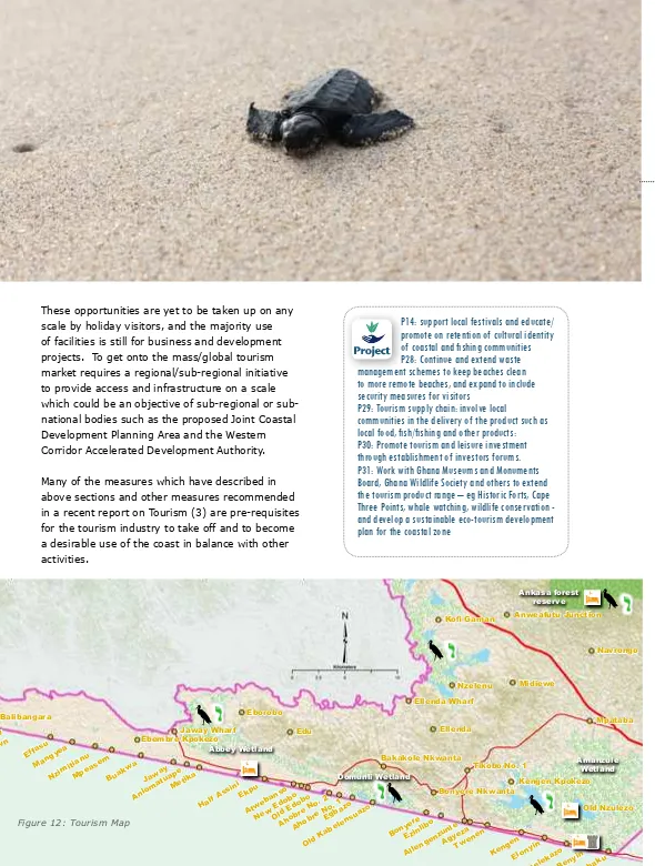
Ecotourism
Fish landing site
Fort/castle
Lighthouse at Cape Three Points
Accomodation facility Sandy beaches Coastal lagoon inlet Rocky shores N1/Highway Major road Proposed roads Buffer
Perception of shoreline 30 years ago Perception of shoreline 60 years ago Shoreline extend within community Drains
100 year shoreline Green belt
Gas pipeline
District boundary
Water body
River
Mangroves / Wetland 1974 shoreline Natural vegetation
Tidal inluence (yet to be determined)
Coastal Zone
Town
Community Resources Management Areas (CREMAs)
Coastal zone (1000 m buffer)
Birds
Crocodiles
Turtles / nursery
Project proposed to be
implemented. Refer to
pages 42-43 for more
information.
Bibliography listed in
section ive.
Examples of Best
Management
Practices in coastal
communities.
Project
Reference
Case
study
Legend
11
1
s
ec
ti
o
n The Coa
st
al Zo
ne and D
e
ve
l
o
pme
nt Co
nte
x
t
Jomoro ICM Toolkit 2013
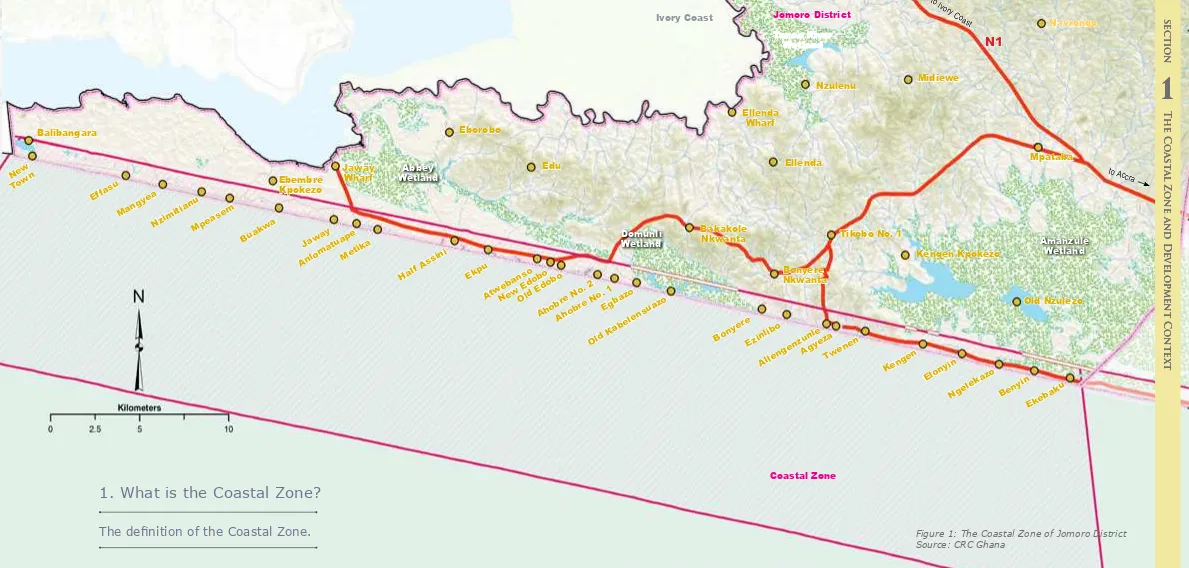
Figure 1: The Coastal Zone of Jomoro District Source: CRC Ghana
Old Ka
belensuaz o
Bony ere
Ezinlibo
Allengenzunle Agyeza
Twenen
Kengen
Elonyin
Ngelekaz o
Benyin
Ekebaku
Ellenda Wharf
Ellenda
Tikobo No. 1
Bonyere Nkwanta
Kengen Kpokezo
Old Nzulezo Nzulenu Midiewe
Navrongo
Mpataba
Bakakole
Nkwanta Amanzule
Wetland Tanoe River
Wetland
Domunli Wetland Abbey
Wetland
Coastal Zone
New Tow n
Effasu
NzimitianuMpeasem
Buakw a
Jaw ay
Anloma tuape
Metika
Half Assini
Ekpu
Atw ebanso New EdoboOld Edobo
Ahobr e No
. 2
Ahobr e No
. 1
Egbaz o Mang
yea
Edu
Balibangara Eborobo
Ebembre Kpokezo
Jaway
Wharf to Accra
to Ivory Coast
N1
Ivory Coast Jomoro DistrictFor planning purposes the coastal zone of Jomoro District is an area with a landward boundary 1km from the shore, or any development in the land area of coastal sub-basins draining seaward, or with a
signiicant likely impact on coastal and marine resources.
For economic purposes, the coastal zone also takes into account activities occurring out to 6 nautical miles seaward, or to a depth of
30m whichever is the greater (coinciding with the ishing grounds of the artisanal ishing leet).
1. What is the Coastal Zone?
The deinition of the Coastal Zone.
A.
B.
1
s
ec
ti
o
n The Coa
st
al Zo
ne and D
e
ve
l
o
pme
nt Co
nte
x
t
1
s
ec
ti
o
n The Coa
st
al Zo
ne and D
e
ve
l
o
pme
nt Co
nte
x
N1
N1
Tourism Zone
Industrial and tou
rism Zone
to Accra to Ivory Coast
Former border crossing point
Ankasa Forest Reserve
New Tow n
Effasu
NzimitianuMpeasem Buakw a
Half Assini Ekpu Atw
ebanso New EdoboOld Edobo
Ahobr
Tikobo No. 1
Bonyere Ghana’s oil reserves - Jubilee
oil ield
Elubo
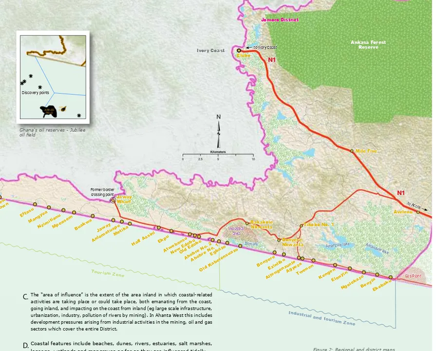
The “area of inluence” is the extent of the area inland in which coastal-related
activities are taking place or could take place, both emanating from the coast, going inland, and impacting on the coast from inland (eg large scale infrastructure, urbanization, industry, pollution of rivers by mining). In Ahanta West this includes development pressures arising from industrial activities in the mining, oil and gas sectors which cover the entire District.
Coastal features include beaches, dunes, rivers, estuaries, salt marshes,
lagoons, wetlands and mangroves as far as they are inluenced tidally
(1), so the coastal zone in some cases, extends beyond 1km from the
outer edge of these coastal landscapes or ecosystem features (for detail
see Figure 3).
1.2 Area of inluence:
socio-economic context
The context for development in Jomoro can be summarized as follows:
• The presence of the West African coastal highway runs through the district giving unique opportunities for international access; the long term effects of the change in the route from Jeway Wharf to Elubo are still being felt.
• The designation of the Domunli Lagoon site for major industrial development, fed by gas from Atuabo, creates a new growth pole which is an opportunity for Half Assisni, Tikobo and Bonyere – but also a new challenge in achieving a successful balance between this and the maintenance of the very rich ecological goods and services in the coastal zone.
• The Amanzule wetlands are a highly unique feature of Jomoro which
could beneit from being made highly
accessible to visitors to gain support and resources for their protection. • The wetlands and coastal zone
constitute an extraordinarily vulnerable system which has for a long time subjected its inhabitants to severe
hardships from looding, loss of, and
intense competition for land, not least by a very fast rising population.
The competion is intensiied by
the presence of Ghana’s two most
productive oil and gas ields which are
sited off the Jomoro coast. Figure 2: Regional and district maps
showing factors in sphere of inluence
C.
14
Jomoro ICM Toolkit 2013Pocket beach
Watershed draining into
river Upland Forest
River Delta
Rocky
Shore Rocky
Headland
Rocky Shore
Barrier beac h/
spit (backed by lagoon)
Estuary Lagoon (tidal)
Akwidaa New Town
Akwidaa Old Town
FLOODING
FLOODING
FLOODING
Waves that can cause erosion
Net Long shore current and sand
movement
Beach, berm, dunes
River – fresh/salt boundary site
speciic
Wetlands & mangroves SALT BRACKISH
FRESH
Turtle nesting beach
Road to Dixcove River rises with heavy
rain
Coastal features:
• Beaches, Dunes and Barrier Spits, Rocky Bluffs, Rock Outcrops and some Steep Slopes
• River Estuaries, Drainage Outlows, Mangroves, Wetlands Marshlands and Coastal Lagoons • Vegetation, lora, tropical foliage forests, fauna,
birds, small invertebrates, sea turtles
Dynamics:
Sandy shorelines are highly dynamic features that evolve in response to waves, currents, tides and wind. In many cases sandy beaches are built up by ocean wave energy and backed by wetlands
or river outlows, and are referred to as barrier
beaches. These systems are in constant movement in response to the energy of the surrounding system, and as a result are not advisable building sites.
Figure 3: Detail of coastal zone showing
typical features
Source: CRC Ghana
1
s
ec
ti
o
n The Coa
st
al Zo
ne and D
e
ve
l
o
pme
nt Co
nte
x
Integrated Coastal
Management -
why, what and how?
Section
two:
17
18
2
s
ec
ti
o
n I
ntegra
te
d coa
st
al m
anageme
nt
Hen Mpoano, the Integrated Coastal and Fisheries Governance initiative, beginning in 2009, has worked with all stakeholders to get to this stage where the necessity of understanding, the “why”, the “what” and the “how” of Integrated Coastal Management can become clear.
2.1 Why?
The coast of Jomoro District surely represents one of its most distinctive features, which give it one of its greatest competitive advantages. But the development opportunities need to respect the right of communities, which have lived here for centuries past, to also continue to enjoy a prosperous and harmonious life. All will have to meet the ongoing socio-economic challenges exacerbated by climate change and coastal erosion. Those living inland, within the District, are also highly dependent on the health and well-being of the coast.
The Rapid Assessment of Communities in Ahanta West (1) showed the following key points:
• Land Use pressures: the discovery of oil and gas has created a rush for land by prospective investors and
speculators in industrial and other related development as well as pressure on the district’s 61km stretch of coastline for development of residential, leisure and hospitality. This, coupled with the huge area which is taken up by the wetlands creates strong competition for the space
available, including that for ishing and
for subsistence agriculture. These are generating concerns for more effective land use and spatial planning that addresses existing vulnerability.
• Fisheries decline: Bad ishing practices coupled with the regular incidence of algal bloom in the marine environment
is resulting in dwindling ish catch and displacing ishery-based livelihoods and
threatening food security. This problem is aggravated by the prevailing low agricultural productivity in the district. • Coastal Eco-Systems threatened:
Incidence of sand winning and sea erosion, destruction of mangroves, wetlands and drainage systems, sedimentation of major rivers.
• Other concerns: community perception of inadequate government representation and attention; low community participation in resource allocation decision-making, chieftaincy disputes; poor road access/ infrastructure; rising social problems; general lack of Primary and Junior High school education; availability ofelectricity, pipe-borne water, public toilets, health posts and refuse containers.
R1: Our Coast, Our Future: Western Region of Ghana
This is a major product of the Hen Mpoano
initiative. It makes the case that a fresh
approach to the governance of the coast and isheries will take root only when it addresses issues that are perceived by the people of the place as important. It covers the major coastal and isheries issues and concludes with a discussion of the actions that Hεn Mpoano proposed to take over a three year period to establish and formalize a governance program
for the Western Region that can serve as a
model for the nation.
Reference
2.3 What? The Core
Elements of Integrated
Coastal Management
The response to pressures of development
could in fact generate long term beneits
for coastal ecosystems and their dependent communities. The following core elements of Integrated Coastal Management strategy could possibly be sanctioned by the district, by forming a Marine and Coastal Committee, as has been done at Ahanta West. Alternatively the remit of the Amanzule Working Group could be expanded to include implementation of such a strategy:
• Preservation and restoration of important coastal habitat and features that are critical
to sustaining the ishing industry.
• Expanding Community Resource
Management Areas (CREMAs) in existing conservation management clusters to cover other important coastal wetland areas and features.
• Creating Land Use and Environmental Policies that balance competing interests of industrial, tourism, food and livelihood security, leisure, commercial and residential activities while protecting the vital
ecological functioning of the land and seascape.
• Supporting traditional and inding new livelihoods for coastal communities through
agriculture, isheries and aquaculture, as
well as providing the access to fully partake in the new forms of development.
• Reducing vulnerability and building adaptive capacity of coastal communities to threats from hazards and climate change including extreme weather, rising sea levels and coastal erosion.
• Sustained stakeholder enagement and moves to build co-operation with neighboring districts through a Joint Coastal Development Planning Area; and creating effective links to the regional and national levels of government.
2.4 How? Systems for
implementing Integrated
Coastal Management
Integrated coastal management is a participatory process that engages communities, private sector, traditional authorities and civil society. The mechanisms for implementation at the district level are:
1. The District’s Medium Term Development Plan (MTDP), and Community Action Plans which address settlement growth, economic development and the provision of schools, clinics, other services, roads and infrastructure.
2. The District’s Spatial Development
Framework (SDF), Structure Plans (SPs and Local Plans (LPs), which show what can go
where, and resolve potentially conlicting
demands on land use in the coastal zone. 3. Strategic Environmental Assessment which
ensure that the necessary environmental protection measures are taken.
The formation and activities of the Amanzule
Working Group is a irst step at ensuring
that the greater Amanzule wetlands, which are shared between Jomoro and Ellembelle districts, attain formal conservation status and is recognized in the spatial plans of both districts. The establishment of a Marine and Coastal Committee as in Ahanta West district could also be a great step forward for implementing Integrated Coastal Management in Jomoro. It could provide a necessary forum
for integration across sectors such as isheries,
offshore oil and gas activities, land use and fresh water supply. The Committee could
support issue identiication and assessment,
suggest and shape policies, prioritize actions and evaluate outcomes as the Coastal Zone is developed.
At the regional and national scales, many of the objectives of coastal management may only be achieved through joint planning and implementation, involving adjoining coastal districts. For this reason, initiatives such as the Data Hub which has been established at
2.2 The Most Urgent Issues
The coastal zone of Jomoro District is undergoing rapid transformation due to
activities of a fast growing oil and gas industry. A balance must be found between development
and the low of coastal ecological goods and services. There is a need to conine oil and
gas-related development to certain “hot spots”
(as identiied, for example by the Western
Regional Spatial Development Framework), to maintain sustainable livelihoods, protect the environment and the areas of high landscape value (“green belt areas”) which have been
identiied, while encouraging economic
the Western Regional Coordinating Council by Hen Mpoano for technical support, the
ledgling Joint Development Planning Area for
the Coastal Districts of the Western Region, and Western Corridor Accelerated Development Authority must be supported by all.
This joint approach to planning and decision-making can involve;
• Adoption of region-wide policies for
preventing and mitigating lood hazards.
• Information sharing on techniques for assessing hazards and adaptive capacity of coastal places (eg those used in vulnerability assessment and adaptive planning exercises at Dixcove and Akwidaa).
• Collaboration between agencies at regional and national levels on coastal issues. • Effective mechanisms for conlict resolution
and dialogue with parties affected by development decisions.
• Joint initiatives on protection/restoration of critical habitats, forests and wetlands of
regional signiicance by programs such as
Community Resourced Management Areas (CREMAs).
• Decision making on large facility siting and management of alterations of the coastal zone.
All of these will become more evident in coming years if detailed planning and decision-making can be done at community level and linked to regional and sub-regional co-ordination of national and international investments.
P1: Form Working Groups to deal with speciic
coastal issues, for example the Amanzule
Working Group
Project
Section
three:
JOMORO DISTRICT
COASTAL PROFILE AND
DEVELOPMENT ISSUES
2.4 Opportunities to
Implement Integrated
Coastal Management
Use of the above planning and decision making processes and environmental assessment provides the foundation for Integrated Coastal Management. District Assemblies suffer from chronic underfunding, but many development partners (governments of United States, Norway, France, Germany, Korea, Belgium, United Kingdom) and private sector such as the Jubilee Partners are funding projects which provide essential parts of the process, including community linkages. These need to be made sustainable in the long term by funding mechanisms such as Assembly’s Internally Generated Funds (eg from property rate, betterment and value capture in new projects), Corporate Responsibility funds of major private investors such as in a Coastal Foundation, and national and international funds for infrastructure and investment.
21
Jomoro ICM Toolkit 2013 Jomoro ICM Toolkit 201322
3
s
ec
ti
o
n J
O
M
O
R
O D
ISTRI
C
T COA
ST
AL PR
O
FILE AND D
E
VEL
O
PMENT ISSUES
R2: Adaptive Capacity for Resilient Coastal
Communities: Climate Change and Natural
Hazards Issues in Coastal Districts of
Ghana’s Western Region
In 2011 and 2012, Hen Mpoano assessed 77 Western Region coastal communities in the Districts of Jomoro, Ellembelle, Nzema East and Ahanta West to gain an understanding of their concerns and capacity. The indings indicated that adaptive capacity is limited in coastal communities. Some locations are faring better than others, but overall, coastal communities have weak ability to respond to emergencies generated by natural hazards, they suffer social and economic development challenges that are worsening, and they have a relatively low ability to manage coastal resources in a way that will ensure sustained productivity and environmental quality.
3.1 Characteristics of the
Coastal Zone: overview
The Jomoro District shoreline is relatively rural with a mix of land and water uses which underpin local cultures and livelihoods. It is characterized
by a long stretch of relatively lat sandy beaches
and dune systems with elevation below 10 metres. The majority of the district’s population live in
dense ishing settlements with ish landing and processing areas on the irst dune. This population
is hemmed between the sea and the vast Amanzule wetlands. Few hills of rocky outcrops protrude between the sandy beaches and sometimes extend into the sea forming rocky sea beds. The shoreline from the western boundary of Ghana to Ahobre is part of a narrow, 7-10km wide strip of land which bounds the Abby lagoon which is mostly in La Cote D’;Ivoire. Until recently, this was the main international route across the border to Abidjan by ferry, with the District Capital, Half Assini, as its heart, also the centre for a thriving coconut industry. The route dips back from the coast at Ahobre to circumvent the Domunli Lagoon, which has the town of Bonyere at its eastern side. From Bonyere to Beyin is a further long stretch of coast
with coconut groves separating ishing villages.
Beyin is the location of a paramount chieftaincy of the Nzema people, and a growing tourist
resort with the Nzulezu stilt village inland on the Amanzule Lake, as its star
attraction.
The coast line is linked to, rivers, estuaries and
the greater part of the vast ecologically signiicant
Amanzule wetland complex that provides habitats
for diverse lora and fauna. In the uplands there
are forests and rich agricultural lands.
life including juvenile ish and their breeding, and
Marine Protected Areas are being proposed to
protect isheries and improve food security.
Marine areas experience many other uses such as for a local, national and international highway, for leisure, cables, pipelines, oil and gas exploitation. The Marine areas are subject to increasing kinds of pollution from the wastes of marine and non-marine activities (dumping of waste). As capacity for coastal management increases, spatial planning for the seascape will be necessary to ensure harmony between traditional uses of
the sea for ishing and oil and gas production
activities. Marine Spatial Plans are now being used throughout the world to cope with the increasing pressures.
Sandy beaches Coastal lagoon inlet Rocky shores
3.2 Characteristics of Coastal
Zone: off-shore marine areas
and isheries
The off-shore areas of the coastal zone are
actively used by the artisanal (traditional) ishing leets. Fishing is also the province of larger, Ghana-based semi-industrial ishing vessels
and industrial, intercontinental vessels. There
are locally breeding ish, those inhabiting the
Guinean current across West Africa and those that migrate across larger distances (such as blue
whales). Surveys have been carried out to determine the location and
type of marine
3
s
ec
ti
o
n J
O
M
O
R
O D
ISTRI
C
T COA
ST
AL PR
O
FILE AND D
E
VEL
O
PMENT ISSUES
P2: Prepare Marine Spatial Plan
P3: Continue with research on Algae
Bloom leading to proposals for its
management.
R3: Nearshore Rocky Reefs of
Western Ghana, West Africa:
Baseline ecological research surveys.
Ateweberhan,M.,Gough,C., Fennelly L.
and Frejaville, Y. 1.
Project
Reference
Ecological information on the near shore rocky reef habitats (NSRH) of Ghana is very limited. The present study ills this knowledge gap, by investigating the general status of the NSRH and isheries of western Ghana, and providing baseline information on the ish, invertebrate and benthic communities.
R4: Assessment of Fishing Grounds in the Nzema East and
the Ahanta West Districts
A rapid appraisal conducted in nine (9) main landing sites in the Nzema East and Ahanta West districts between 14th and 21st September 2010. The communities visited were, Ankobra (Sanwoma), Apewosika (suburb of Axim), Miamia, Princess Akatakyi, Cape Three Points, Akwidaa, Dixcove, Busua and Butre. The purpose of this assessment was to ascertain primary information of the spawning and ishing grounds among others. The research team was made up of two persons; a staff of the Western Regional branch of the Ghana Canoe Fishermen Association and a staff of the Friends of the Nation. Data was collected through focus group discussions, participatory mapping, direct observations and key informants interviews.
R5: Determining The Origin And Ecology Of A Macroalgae
(Ulva clathrata) Bloom Along The Coast Of Western Ghana
And Cote d’Ivoire.
Figure 5:
Sensitive areas in
need of protection in
Jomoro District.
Former border crossing point
Assini Ekpu
Atw ebanso New EdoboOld Edobo
Ahobr
Marine protected areas Jaway Wharf
o Amanzule lake
Gas Plant
TwenenKengen Elonyin
Ngelekaz o
Benyin Tikobo No. 1
Bonyere Nkwanta
Figure 6: Community perception of coastal erosion.
3.3 Characteristics of the
Coastal Zone: areas of
restoration and preservation
The coastal zone of Jomoro is associated with wetlands, mangroves, lagoons, rivers and estuaries. These provide essential ecosystem services and are also critical for maintaining a
healthy ishery (see section 3.4.2 below). These
ecosystems are a priority for conservation.
Some of these ecosystems are already oficially
recognized and those that are of more local
signiicance should also be differentiated.
Ultimately this could include the marine part of the coastal zone with protected areas such as Marine Conservation Areas and Sanctuaries, Fishery Conservation and Closure Areas, and Essential Fish Habitats.
P4: Undertake public education on the
beneits of conservation of coastal
ecosystems.
P5: work with Marine Protected Areas
Inter ministerial Committee over
designation of marine protected
areas.
Project
3.4. Relief, Drainage and
Climate: Coastal Dynamics,
Human Uses and Implications
3.4.1 Shoreline Beaches, Dunes and
Barrier Spits: human and natural
hazards
Due to the action of wind, waves, current and rising sea level in recent decades, most barrier beaches in Ghana are retreating at a rate of about 1m per year and in the Western region, are estimated to be retreating at 2m per year on the average (2). Erosion, sea level rise, and sand winning from the beach can all result in land loss and the inland movement of the shoreline.
While the rate of erosion slightly varies from one coastal community to the other, sections of the shoreline in the district are noted to have eroded by approximately 50 meters over the past 2 decades, causing the disappearance of buildings, farm lands and other properties. This phenomenon still continues due to high sea wave energy and evolving sea level rise
due to climate change. And it has initiated a dificult
process of relocation. For instance, most people who lived in Old Kabenlansuazo moved to resettle at New Kabenlansuazo about 50 years ago. Other communities facing greater impact of coastal erosion include Metika and Twenen.
P6: Increase collaboration with the Ministry
of Water Resources, Works and Housing for
regulating private development and installing
publicly funded defenses.
P7: Where acceptance of land loss is agreed as the
best option long term, plan re-settlement schemes and
incorporate as objective in Structure Plans.
P8: Develop a public education programme on coastal
hazards and climate change
P9: End destructive sand winning practices by use of bye
laws and community sensitisation
P10: Prepare coherent shoreline management plans to
regulate coastal land use.
R6: Report on Characterization of coastal
communities and shoreline environments in the
Western Region of Ghana.
This report provides information on the conditions and environmental, social and economic issues faced by 89 coastal communities in the six coastal districts of Ghana’s Western Region. Rapid appraisals of coastal communities, district level validation workshops and secondary literature review were undertaken to provide additional information that will ultimately contribute to assembling the baseline. While rapid appraisals gleaned community scale information, it also provided the opportunity to socialize the initiative among coastal communities visited. The purpose of district scale workshops was to solicit inputs from local people as well as reactions to indings of the rapid appraisals and to incorporate local perceptions of changes into a district level synthesis of coastal and isheries governance issues.
Most stakeholders in the coastal communities accept the fact sand winning contributes immensely to coastal erosion. But their perception is that small scale sand winning, for household use such as building and its
rehabilitation does not signiicantly add up to
the problem.
In almost all the coastal communities, there are traces of coastal erosion. In most communities, properties and activities that prevailed at the beach in the past such as play grounds, coconuts, cemeteries, roads and houses have been destroyed. For instance, in Twenen, community members noted that their current residence marked their third settlement. Their last place was called Twenwo, and they predict that they might have to move again in the next 20 years. Similarly, in Ellonyi, a coastal community located near the River Ellonyi; a vehicular road and coconut trees located near the beach about 35 years ago have been destroyed by erosion. Likewise in Ngelekazo, inhabitants noted that there has been increasing coastal erosion dated 70 years ago and has destroyed key recreational areas and coconut plantations. The situation and destruction of property is not different from Old Kabenlansuazo, Agyeza, Allengenzule, Ezinlibo and Egbazo. Particularly in Egbazo, residents described how their borehole that had been destroyed by erosion.
Good Management Practices
Support Urbanization, Sanitation and Wastewater
Management in the Coastal Zone:
Dixcove Case Study
Case
Shoreline extended within community
Jomoro ICM Toolkit 2013
25
Jomoro ICM Toolkit 2013 Jomoro ICM Toolkit 201326
3
3.4.2 River estuaries,
Drainage Outlows,
Mangroves, Wetlands,
Marshlands and Coastal
Lagoons
Wetlands and coastal water resources serve vital functions in the environment. They provide habitat for many plants and animals, including migratory
birds and many types of ish. Mangrove areas, in
particular, are important to the overall health of
the marine isheries, because they provide habitats for shellish as well as nursery grounds to juvenile ish. Mangrove wood is harvested for a variety of
purposes, but this practice should be limited due to the damage to wetlands that overharvesting causes.
From a hydrologic perspective, wetlands serve to dampen the effects of changing water levels,
thereby providing protection from looding. In the process of slowing loodwaters, wetlands
trap and store sediments, limiting erosion and in some cases actually building up soil. Through this
R7: Rapid assessment of mangrove status and
conditions for use to assess potential for marine
payment for ecosystem services in Amanzule and
surrounding areas in the western coastal region of
Ghana, West Africa
Ghana’s mangrove ecosystems are tremendously valuable, providing ecosystem services like carbon sequestration, protection from storms, loods, and erosion, provision of timber and non-timber forest products, processing of waste and nutrient pollution, aquaculture and agriculture support, and habitat for aquatic and terrestrial species. Yet, as in many other parts of the world, short-term development needs are undermining long-term mangrove health and survival. Fortunately, economic mechanisms have the potential to tip the balance toward restoration, maintenance, and protection of mangrove forests. The need for proper valuation of mangrove ecosystem services underpins such mechanisms towards the establishment of any realistic payment for ecosystem services scheme in any given mangrove or wetland habitat.
R8: Coastal Hazards and Flooding Risk in Ghana’s Western Region
This issue brief highlights the key issues facing Ghana’s Western Region in terms of coastal looding in low-lying areas as well as shoreline erosion, and recommends policy options to improve public safety and reduce environmental impacts.R11: Biodiversity Threats Assessment for the Western Region of
Ghana.
This review of biodiversity threats in the coastal zone of
Good Management Practices
Reduce Impacts from Flooding and Erosion:
Akwidaa Case Study
Case
study
process, they protect coastal waters from excessive runoff and sedimentation. Coastal communities often rely on these areas for their drinking supply,
so maintaining the low levels and cleanliness of the
water is vital to community health.
Wetlands are easy targets for dumping of waste and
inilling because they lack existing users or owners.
They are also under threat from indiscriminate
cutting of mangroves for ire wood for cooking and ish smoking. The practice is very common, partly
due to low level of awareness of their ecological functions and services.
In most coastal communities in the Jomoro district, there is intense cutting of mangroves around the lagoon as well as building of houses near wetlands.
the Western Region of Ghana covers both terrestrial and marine systems and includes maps and descriptions of important wetlands and habitats.
R12: Rapid Biodiversity Assessment on the Essei and Butuah
Lagoons and the Whin River Estuary in the Sekondi-Takoradi
metropolis of the Western Region of Ghana
This rapid Biodiversity Assessment on the Essei and Butuah Lagoons and the Whin River Estuary in the Sekondi-Takoradi metropolis of the Western Region of Ghana concludes that deplorable management, ignorance or conlict of interest on the part of users has led the wetlands onto a path of potentially irreversible destruction. A new type of coastal management thinking and practice are needed that takes into account Ghanaian economic, socio-cultural and environmental perspectives.
R13: Approved byelaws for wetland conservation in 4 areas (Butre,
Busua, Akwidaa, and Princes town)
Cape Three Points – Princes’ Town CREMA Constitution and Resource Management Bye-law was amended to include provisions that call for the development of management plans for CREMA wetlands. The revised bye-law was approved by the Assembly.
R14: Model Bye-laws for Coastal Management in Ghana:
Experiences from Shama District
Through Hen Mpoano-facilitated technical assessments, stakeholder engagements and participatory mapping exercises, model bye-laws and policy statements for lood hazard mitigation, shoreline and wetland management were formulated and approved by the district assembly.
3
s
ec
ti
o
n J
O
M
O
R
O D
ISTRI
C
T COA
ST
AL PR
O
FILE AND D
E
VEL
O
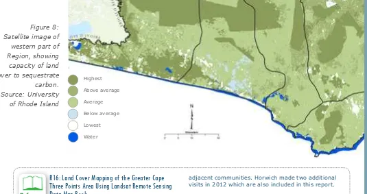
Highest
Satellite image of
western part of
Region, showing
capacity of land
cover to sequestrate carbon. Source: University
of Rhode Island
3.5 Vegetation, Flora, Tropical
Foliage Forests, Wildlife
3.5.1 Coastal Vegetation, farming,
forest reserves.
The current majority land use in Jomoro District is by the wetlands, subsistence farms, trees and
forest. Of greatest signiicance in terms of carbon sequestration, freshwater supply, ish habitat and lood control is the Amanzule wetland which
straddles Jomoro, Ellembelle and Nzema East and extends to the border with neighboring Côte d’ Ivoire. Even with its close proximity to the coast, this wetland is largely a freshwater system except along its southeastern terminus where the
outlet parallels the coast before inally emptying
into the sea near Azulenoanu. This ecosystem is composed of several wetland categories including swamp and mangrove forests and holds Ghana’s only known peat swamp forest and the country’s largest intact swamp forest. A baseline land cover
for the Amanzule area (see ig 7) has been deined
to assist in change detection and analysis going forward.
The Ankasa Forest Reserve is the major Forest Reserve in the District, and is one of the largest designated for ‘protection’ rather than ’production’ in Ghana. The park recognized for its guided nature
walk by most tourist remains of high signiicance
due to its high plant diversity, indigenous forest birds, monkeys especially chimpanzee and forest elephants.
Coastal communities combine farming and ishing
for their livelihoods, with a mixture of cash and
subsistence food crops. Their farming has suffered from the severe decline of the formerly prosperous coconut crop through Cape St Paul Wilt disease which slowly spread throughout the coast from 1932. This fed lucrative pig farming and coconut oil production. Rather than replant expensive and slower growing disease-resistant coconut hybrids,
farmers have switched to less proitable oil palm.
This has added to the pressure on livelihoods
from declining ish stocks. Subsistence food crop
areas suffer from over exploitation and subdivision among increasing number of family members.
The balance between income from cash crops and land available for food, is a key factor in sustaining livelihoods and food security. The mapping of rural land uses will enable decisions to be made about
the most eficient balance of uses. This designation
of land for agriculture, added to protected areas/ corridors for wildlife will enable the best decisions to be taken about which areas are suitable for urbanisation, tourism, leisure and industrial development.
R16: Land Cover Mapping of the Greater Cape
Three Points Area Using Landsat Remote Sensing
Data Map Book
This is the companion book of maps for the land cover study. The land use and land cover map products created in this study are the irst available data for the coastal region of Ghana. The maps represent an important step in the management of its natural resources. Land use and land cover maps allow land managers, policy and decision makers, and local communities to make informed decisions about the future of their natural, cultural and economic resources. This set of maps can also provide a window into how the landscape has changed as the baseline data for possible future work. With the baseline data ready, the next step of change analysis will be possible. The choice to use the U.N. Land Cover Classiication System also provided the lexibility to meet classiication needs in the future while still maintaining continuity with past work.
R17: Report from Community Conservation on Primates in the
Western Region.
Field notes from Horwich’s site visit and
recommendations for improved management of the forest reserves and alternative livelihoods for the
P14: Map and plan rural land uses areas.
Develop strategy for balance of agricultural
land uses and set buffers for food crop
production as well as conserve ecosystem
functions and services.
P15: Develop the eco-tourism potential of
Greater Amanzule Wetlands.
P16: Establish green networks in District Spatial
Development Framework and to protect wildlife,
agricultural and forest areas. Include green
corridors in Structure Plans and Local Plans.
Project
Figure 7:
Land cover classiication for Amanzule wetland.
Open broadleaved deciduous forest Mosaic forest - Shrubland / Grassland Mosaic Grassland / Forest - Shrubland Closed to open shrubland
Closed to open grassland
Sparse vegetation
Closed to open broadleaved forest regularly looded (fresh/brackish water)
Closed to broadleaced forest permanently looded (brackish-saline) Artiicial areas
Bare areas Water bodies Rainfed Croplands
Mosaic Croplands / Vegetation Mosaic Vegetation / Croplands Closed to open broadleaved evergreen or semideciduous forest
adjacent communities. Horwich made two additional visits in 2012 which are also included in this report.
R18: Land Cover Mapping of the Greater Cape Three Points
Area Using Landsat Remote Sensing Data
The land use and land cover map products created in this study are the irst available data for the coastal region of Ghana. The maps represent an important step in the management of its natural resources. Land use and land cover maps allow land managers, policy and decision makers, and local communities to make informed decisions about the future of their natural, cultural and economic resources. This set of maps can also provide a window into how the landscape has changed as the baseline data for possible future work. With the baseline data ready, the next step of change analysis will be possible. The choice to use the U.N. Land Cover Classiication System also provided the lexibility to meet classiication needs in the future while still maintaining continuity with past work.
29
Jomoro ICM Toolkit 2013 Jomoro ICM Toolkit 201330
3
PMENT ISSUES
3.6 Settlements, Spatial
Analysis, and Siting of
Infrastructure,
3.6.1 Growth of the Coastal and
Fishing Settlements
The population of the Jomoro district has increased over the years from 37,685 in 1970 to current population of 150,107. The initial increase in population between 1970 to 2000 was partly attributed to the completion of the international highway linking Ghana to La Cote d’Ivoire which led to increases in commercial activities and
resulted in the inlux of people to the district.
However, the recent increases in population as gleaned from community interactions during the
rapid assessments were inluenced largely by high immigration of isher folks especially from
the Central Region, uncontrolled births, teenage pregnancy resulting and its associated high school drop-out rate. Planned oil and gas facilities in the area and provision of auxiliary services for the petroleum industry were also cited as potential contributing factors to the increasing population.
3.6.2 Cultural context
and traditions in Coastal
Communities
Artesanal ishing communities represent a unique
and distinct culture which arises from the activity. Fishermen are at sea in canoes for three to four days at a stretch, while others are mending and
making boats, nets and ishing gear. Women prepare, smoke and sell the ish. The district is
seen as homogenous in terms of ethnicity but with Nzemas constituting 65.4% of the total population and Nzema as the main language spoken. Migration is a common practice in the
ishing industry. This is rife between July and September (the high ishing seasons) when coastal
communities in the district experience massive
inlux of ishermen.
Prominent religious practices in the district are Christianity with Traditional and Islam. However, the majority of the people in the district are
is vested in the Western Nzema Traditional Council with the Omanhene (Paramount Chief) as its President. All the Chiefs in the district owe allegiance to the Omanhene who is also the Paramount Chief of Jomoro and has his seat of authority in Beyin. The district has four divisional Chiefs with their seats located at Nuba, Mpim, Half-Assini and New Town.
By far the main festival in Jomoro is Kundum (locally called Abisa). The festival, mostly celebrated between August and November, lasts at least seven days and rotates between communities. It features prominent traditional dance and drumming. In communities where the Kundum festival is celebrated, rituals are performed to pacify and honour the gods of the wetlands and other gods. The festival is also a key unifying force as it brings together families and people from in and outside the District. It is however crucial to emphasize that chieftaincy disputes are prominent in coastal communities like Bonyere and Newtown. This source of dis-unity and disorganization has impacted in information
low, social well-being, peace and security in the
communities.
P33: Support local festivals and educate/
promote on retention of cultural identity of
coastal and ishing communities.
P34: Work with Lands Commission
at local level on land security and
compensation
R19: ‘Faith In Action’ Faith Based Action For
Creation Care In Coastal Communities Of
Western Region.
This report details engagement with religious leaders in six coastal districts in the Western Region of Ghana from the 12th of December 2011 to the 9th of February 2012. In all, over 123 religious leaders were trained in reference theology on environmental stewardship and creation care. The programme led to the establishments of six interfaith eco-networks in six coastal districts in the western region of Ghana. The programme was a big success and both participants and organisers beneitted immensely from the exchanges and experiences shared. The main recommendations for keeping the ire burning is ensuring that the eco-networks which have been established live beyond the lifespan of the initiative to perform the functions of mobilising religious organisations and advocating for responsible coastal resource use.
Project
Project
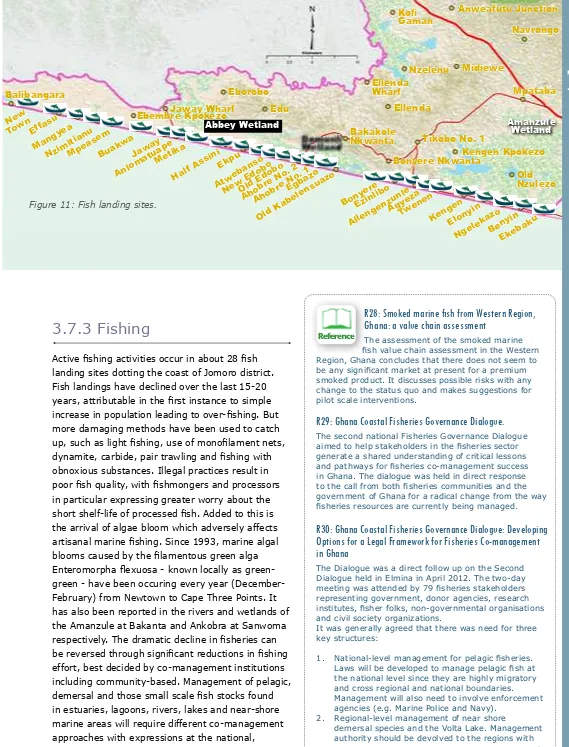
Alomatoape, Jaway. Metika, Half Assini, Ekpu, Old Edobo, New Edobo, Atwebanso, Ahobre No.1, Ahobre No.2, Egbazo, Old Kabelasuazo, Bonyere, Ezinlibo, Allengenzule, Agyeza, Twenene,Kengen, Eloyin and Ngelekazo, Benyin and Ekabaku.
The road network for the coastal settlements is generally poor, but it should be recognized that the oil-related development will drive its improvement. In this regard, the coastal road from Atuabo in Ellembelle (site of the gas plant) to Bonyere is already being improved. The development of the very substantial industrial/ petrochemical site at Domunli Lagoon provides an opportunity to upgrade infrastructure and provide connectivity from Bonyere, through Tikobo to Half Assini.
The scale of urbanization which is typical of coastal settlements in the western region quickly became apparent when Hen Mpoano was working with the community at Dixcove. From aerial imagery it is clear that the area of displacement and resettlement that is being considered by
the existing ishing and farming community was
only a small part of the area which is becoming earmarked for development. Dixcove and Busua are likely to become merged with Butre in the foreseeable future in one large conurbation.
This type of expansion which is evident all along the coast, can happen in a way which creates orderly, modern towns in which the existing
community and incomers both beneit from a
high quality environment. Investment in social amenities, water, power, connecting roads, water courses needs to be made for the larger urban area which includes the existing area.
A pre-requisite for this is the preparation of Structure Plans for the above mentioned key settlements (Half Assini, Tikobo, Bonyere), to be
identiied in the Spatial Development Framework
which should itself be aligned with the Medium Term Development Plan.
Once the plans have been prepared,
implementation should be able to be inanced
by new investors if the planning and permitting process aims for high quality, high values and negotiates sharing of improved land values.
3.6.3 Land ownership
Traditionally, land was in the “customary ownership” of chiefs, who dispensed and allocated it on behalf of their people.
Subsequently the colonial authorities negotiated treaties under Romano-British law which
lead to individual land titles and leases being granted, and substantial land being taken into government ownership. Where most land is not
registered, there are frequent conlicts over
its ownership. Families who have subsisted on the land for generations are summarily evicted without compensation, and incoming investors are caught up in land disputes so that nothing materializes. In areas around Bonyere, for example, farmers (coconut plantation owners) are agitating for adequate compensation for fruit trees destroyed by authorities to make way for gas pipeline laying.
All of this requires that the land agencies should work more closely with local communities; that land transfers by chiefs should be transparent; and that adequate compensation systems are in place where families are dispossessed of their land by development. The land agencies currently operate in a very separate institution. By resolving this element, the implementation of Integrated Coastal Management will become easier.
3.6.4 Spatial Analysis:
Coastal Settlements in
Jomoro
There are 29 communities on the coast of the Jomoro District. The most populated areas in the District are the district capital-Half Assini, Elubo, Bonyere and Tikobo No 1, with three major market centres in the district located at Jeway Wharf, Tikobo No. 1 and Ellubo.
The principle coastal settlements are, from west to east: Avolenu (New Town), Efasu, Mangyea, Enzimitianu, Mpeasem, Buakwaw, Number 4,