DEPOSITIONAL MODEL OF NGRAYONG
FORMATION IN MADURA AREA, NORTH EAST
JAVA BASIN, INDONESIA
Paike Htwe∗1,2, Sugeng Sapto Surjono2, Donatus Hendra Amijaya2, and Kyuro Sasaki3
1Geology Department, Magway University, Magway, Myanmar
2Department of Geological Engineering, Gadjah Mada University, Yogyakarta, Indonesia
3Department of Earth Resources Engineering, Faculty of Engineering, Kyushu University, Fukuoka, Japan
Abstract
The early Middle Miocene Ngrayong Formation, an important reservoir of North East Java Basin, is well exposed in the central anticlinal part of Madura Is-land. The purpose of current study is to classify the depositional environments of the study area based on the characteristics and geometry of sedimentary facies. In the Madura island, the thicker clastics and deeper carbonates of Ngimbang Formation and Kujung Formation of Late Oligocene-Early Miocene deposited in the northeast-southwest asymmetrical half grabens. After the deposition of Kujung For-mation, the basin morphology developed nearly east-west trending shelf edge and the deposition of Tuban Formation began. The fine grained complex of Tuban Formation was followed by the Ngrayong Sand-stones deposition. The depositional model of Ngray-ong Formation is being producing of wide variety of depositional environments. Large scale cross-bedded sandstones and bioturbated massive sandstones with thin to medium bedded argillaceous limestone that outcrop in the northern part of the study area are deposited in costal environment. The heterolithic sandstone with planar and trough cross-lamination, fine grained sandstone with interlaminated struc-ture and bioclastic carbonate exposed in the central part of the study area are deposited in upper shallow marine area. Dark grey siltstones and mudstones
∗Corresponding author: P. HTWE, Department
of Geological Engineering, Gadjah Mada Univer-sity. Jl. Grafika 2 Yogyakarta, Indonesia. E-mail: [email protected]
deposited in lower shallow marine area are well ex-posed in southern part of the study area. In conclu-sion, Ngrayong Formation in Madura area is devel-oped in three depositional units which are coastal, upper shallow marine and lower shallow marine.
Keywords: Lithofacies, Depositional environment, Sandstone, Ngrayong Formation, Madura Island, North East Java Basin
1 Introduction
The North East Java Basin, a classic back-arc basin, is situated on the southern margin of the stable Sunda craton. The East Java region can be grouped into five tectonic provinces (Yulihanto
et al., 1995). The study area, Madura Area is sit-uated in the eastern part of Rembang Zone, the northernmost province of East Java. The Rem-bang Zone sequence was strongly influenced by Tertiary clastics and carbonates that form large
petroleum reservoirs (Soetantriet al., 1973).
Ge-omorphologically, the study area is regarded as hilly topographic terrain forming continuous ridges of relatively low relief (Figure 1). Many valleys with various sizes dissected the area in nearly E–W direction.
Figure 1: The Location and topographic map of Madura Area.
such as Brouwer (1957) noted very shallow to marginal marine deposits for this formation.
Latief et al. (1990) interprets that the
deposi-tion area of Ngrayong Formadeposi-tion in Madura
area was the deltaic origin. Ardhana (1993)
concluded, the Ngrayong Formation was de-posited on the continental shallow shelf to
slope areas. The authors who studied the
Ngrayong Formation mentioned that Ngray-ong Formation was deposited on various kinds of environment and a number of sedimentary processes. The purpose of the present study is to identify the depositional setting of Ngrayong Formation based on variation and distribution of sedimentary facies.
2 Materials and Methods
The Ngrayong Formation is generally exposed along east-west trending in the central anticli-nal part of the study area (Figure 2). A num-ber of good outcrops are situated at the quar-ries along the flanks of Madura Anticline, and on the way connected from the Pamekasan to the north coast of Madura (Figure 2). Seven quarries and one road sections are measured in the study area. The thickness of the section was directly measured by Jacob’s Staff and the dip and strike of the strata was measured by Brun-ton Compass. The other field equipment such as Global Positioning System (GPS) to take lo-cations, camera to take photographs and ham-mer are also used in the field. The stratigraphic columns were reproduced by using Surfer 10 software after the field study. The depositional
and types, colour and biogenic content of the sedimentary rock.
3 Geological background
The Ngrayong Formation is mainly composed of quartzarenite sandstones in Madura Island, and shales and sandstones in the Rembang and Randublatung zone. The sandstones are productive in the onshore East Java Basin
(Soetantri et al., 1973; Sharafet al., 2005). These
sandstones are medium- to coarse-grained and moderately to well sorted and exhibit excellent reservoir properties with porosity greater than 35% and permeability’s up to 10 Darcy (IBS, 2006).
The upper boundary of Ngrayong Forma-tion is represented by an erosion surface, with meter-scale conglomerate-filled channels which are overlain by the late Middle Miocene Bulu Formation, a marker bed consisting of massive carbonates rich in larger benthic foraminifera and small patches of corals, red algae and sandy carbonates. The lower boundary between the Ngrayong Formation and late Early Miocene Tuban lithologies is generally gradational con-tact. However, it is locally represented by a few centimeters of glauconitic and broken and stained skeletal grains, suggesting sediment
starvation and possible drowning (Sharafet al.,
2005). The age of Ngrayong Formation is rang-ing from early Middle Miocene to mid-Middle Miocene (J.O.B. Pertamina-Trend Tuban, 1990). Strontium isotope data indicate that the age of Ngrayong Formation constrains between 15
and 13 Ma (Sharafet al., 2005).
4 Paleogeography
Figur
e
2:
The
Geological
map
of
Madura
Island
(modified
after
Supandjono
et
al.
,1992,
Azis
et
al.
,1992
and
Situmorang
et
al.
west trending shelf edge, after the deposition of Kujung Formation (Ardhana, 1993). This struc-tural trend is developed approximately paral-lel along the present northern coast of East Java and Madura.
The major tectonic readjustment have not been appeared during the deposition of the Tuban Formation which is marked by a rela-tively thin clastic sequence on the shelf while bathyal shales accumulated and partially filled the lows to the south. This deposition was the regional setting prior to the deposition of the Ngrayong Formation (Ardhana, 1993).
5 Depositional setting
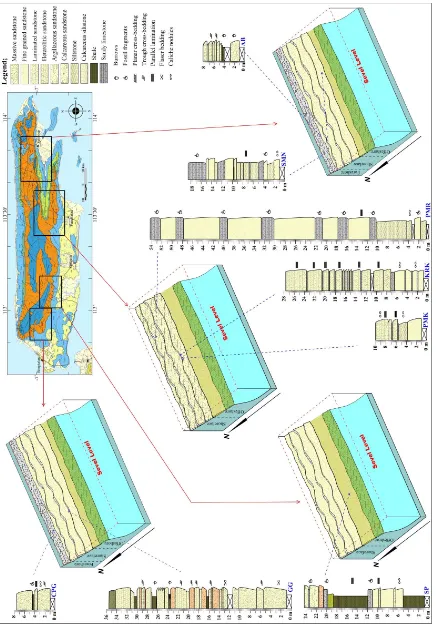
In the current study, the depositional model of Ngrayong Formation establish based on lithofacies distribution and depositional envi-ronments. Seven quarries and one road sec-tions are measured to classify lithofacies and to interpret depositional environment of its. Those eight sections (Figure 3) were AB (quarry near Ambunten River in northeastern part of Madura Anticline), CPG (quarry at Campor Geger village in the north-east of Bankalan), GGL (quarry at Geger Gujug Laut village), SP (quarry at 19km from the north-west of Sam-pang), SMN (quarry at 3km from north-west of Sumenep), PMK (quarry in Pamekasan), KRK (Karukan quarry in northeastern part of Pamekasan) and PMR (road section at the anticlinal part, 18 km from the due north of Pamekasan).
The model presented three depositional units within the Ngrayong Formation (Figure 3) in Madura Area. These are coastal unit, upper shallow marine unit and lower shallow marine unit. Each units have a different areal extend and sedimentary facies as a consequence of dif-fering depositional environments and sedimen-tary processes.
Coastal unit
This unit is well exposed at the quarries in the northern most part of Madura Island (Figure
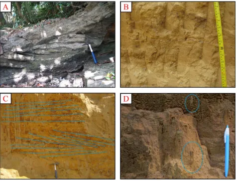
ally thickly bedded, locally massive sandstones are cropped out in these quarries. The sand-stones are yellowish brown, moderately sorted quartz arenite. Large, planar cross beddings are found in this sandstone (Figure 4a). The flaser bedding and mud drape also developed in quartz arenite sandstones (Figure 4b). The parallel laminated sandstones covered over the coarse-grained and thickly bedded quart aren-ite sediments (Figure 4c) in CPG quarry sec-tion (Figure 3). Medium grained thickly bedded quartzose sandstones intercalated with lime-stone. Limestone intercalations are thinly bed-ded, hard, argillaceous and fossiliferous. The vertical bioturbations (Figure 4d) are also com-mon within the massive sandstones in AB (Fig-ure 3) and GGL sections.
The evidences of tidal current such as mud drapes, flaser bedding and cross bedding are characterized in this unit. The cross-bedded quartz arenite in this area was formed in tide dominated channel to subtidal in regressive sit-uation where the mega ripple sand dune
(End-harto, 2004). The vertical burrow structures
in the massive sandstones point out the high energy environments. The bedding character, coarse grained and massive sandstones covered by parallel laminated (Figure 3) are occurred in intertidal coast line area (Nichols, 1999; 2009). This unit is, consequently, the tide dominated intertidal to foreshore environment.
Upper shallow marine unit
This unit is well exposed at the base of Gujug Laut Quarry section (GGL), in northern part of Madura area (Figure 3). This sediments are also seem at SP section, KRK section, PMK section, PMR section and SMN section in the southern part of Madura.
medium-Figur
e
3:
Depositional
model
of
Ngrayong
Formation
in
Madura
Ar
bedded silt layer which include lenticular
sand laminae. Bi-directional cross-laminated
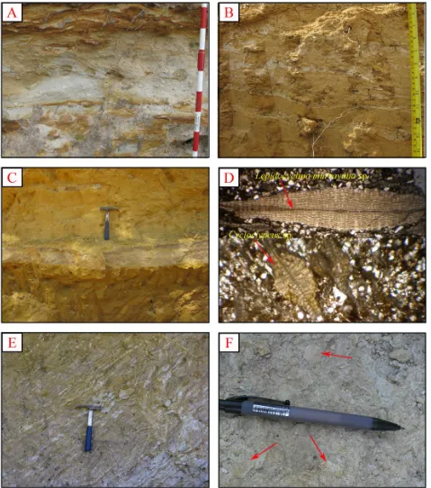
structure is locally found in these sandstones (Figure 5a). These heterolithic sandstones are deposited in lower portion of tidal flat under condition low current speed developed ripple cross-lamination under mix flat produced wavy bedding silty sand and shale (Figure 5b). Fine-grained, medium to thickly bedded sandstones of this unit are exposed at SMN quarry section (Figure 3) and SP quarry section (Figure 3) in southern part of Madura Island. The primary sedimentary structures such as horizontal and parallel laminated structure are common in the fine grained sandstones.
The similar lithology of fine grained sand-stone in SP and SMN sections are encountered in the sandstones of KRK quarry (Figure 3) and PMK quarry (Figure 3). But, these sandstones show laminated structure and more calcare-ous than sandstones in SP and SMN sections. Thin, argillaceous limestone intercalations are occurred in laminated fine grained sandstones
(Figure 5c). Foraminifera,Cycloclypeus sp, and
Lepidocyclina murrayana sp. are found in the thin section of laminated sandstone (Figure 5d). In the PMR road section which situated 15 km northeast direction from KRK quarry section, the sandstones represented similar lithology to laminated sandstone are interbedded with
bio-clastic limestones (Figure 3). Thin, parallel,
horizontal to low inclined laminae (Figure 5e) without reactivation surface reflected suspen-sion sediment deposited in low energy currents in moderate-depth setting are characterized in these fine grained sediments. Where calcare-ous, coarser-grained, more fossilifercalcare-ous, and thicker-laminated of these sediments is indica-tive of a slightly higher energy, lower shoreface environment.
Bioclastic limestones are interbedded with fine grain sandstone in SP quarry, SMN quarry and PMR road sections. These carbonates are dark brown, medium- to thick-bedded, grain supported and fossiliferous sandy limestones (Figure 5f), and contain large foraminifera as
Cycloclypeus sp. with other bioclasts. The
foraminifera, Cycloclypeus sp. are one of the
best paleo-water depth indicators. It occurs
rarely in waters as shallow as 70 meters (225 ft) but only becomes frequent or common in about 100 to 120 meters (330-400 ft) of water (J.O.B. Pertamina-Trend Tuban, 1990). The presence of sedimentary structures developed in tidal cur-rents, lithologic characters and fossil evidences interpreted that these sediments are deposited in tide-dominated, upper shoreface to offshore transition environments (Nichols, 1999; Miall, 2000; Nichols, 2009).
Lower shallow marine unit
This unit is well exposed at at SP quarry section and at the upper portion of GGL quarry section (Figure 3). The lower shallow marine sediments are represented by dark grey mudstones and grey shale. Generally grey, occasionally dark grey and thinly to thickly bedded siltstones are occurred at the GGL section (Figure 3). Dark coloured mudstone contains fine grained, yel-lowish brown, lenticular sand. Thinly lami-nated structures are developed in the siltstone beds. Bioturbation and horizontal burrows are common on the upper surface of these siltstone layers (Figure 6a).
The gray shale that crop out at SP section (Figure 3)were thickly bedded to massive, non-calcareous and less fossil content. It includes thin (1–3 mm), slightly lenticular silty lami-nae. Fissility is common in shale layer (Figure 6b). The laminated and fissile structures, dark colour, very fine grained composition of this sediment are reflected suspension loads fall-out in a low energy setting. Based on litho-logic characters, horizontal bioturbations and sedimentary structures, these sediments are in-terpreted as forming from the deposition in offshore or deep shallow marine environment (Nichols, 1999; Miall, 2000; Nichols, 2009).
6 Conclusion
The measured sections of Ngrayong Formation were taken in the seven quarry sections and
one road section of the study area.
Figure 5: The upper neritic sediments in Madura Area (a) Bidirectional cross-laminae in heterolithic sandstone, (b) The heterolithic sandstone intercalated with mud wavy laminae (c) Fine grained
sandstone intercalated with argillaceous limestone (d) Microscopic view of foraminifera,
Lepidocy-clina murrayana sp.andCycloclypeus sp., in fine grained, laminated sandstone (f) Bioclastic limestone
Figure 6: The lower neritic sediments in Madura Area, (a) Horizontal bioturbations on the surface of dark grey siltstone, (b) Fissile structures in grey shale.
deposited in beaches and foreshore
environ-ments. The upper shallow marine unit that
cropped out in north western part and south-ern flank of Madura Anticline is deposited in tide-dominated, upper shallow shelf environ-ment. The lower shallow marine unit occurred in southern part of the study area are deposited in moderate-depth lower shallow shelf or off-shore environment. The depositional environ-ments of Ngrayong Formation move to the deeper from north to south.
Acknowledgements
The authors would like to be grateful to the AUN/SEED-Net (ASEAN University Network Southeast Asia Engineering Education Devel-opment Network) program and JICA (Japanese International Cooperation Agency) for financial support.
References
Ardhana, W. (1993) A depositional model for the early Middle Miocene Ngrayong For-mation and implications for exploration in the East Java Basin, Proceedings, Indonesian Petroleum Association, twenty second an-nual convention, pp. 395-441.
Azis, S., Sutrisno, Noya Y., and Brata, K. (1992) Geological Map of Tanjungbumi and Pamekasan Quadrangle, Jawa.
Bouwens, A.L. (1983) Correlation profiles-Kawengan, B. P. M. report, unpublished. Brouwer, J. (1957) Stratigraphy of the younger
Tertiary in North East Java and Madura, B. P. M. report, unpublished.
Darman H. and Sidi, F.H. (2000) East Java; in An Outline of the Geology of Indonesia, Pub-lished by IAGI-2000, pp. 54–59.
Endharto, M.A.C. (2004) the Tidal Flat-Shelf Depositional System of the Ngrayong Sand-stone in the Western Part of the Madura, In-donesia Association of Geologist, 33rd An-nual Convention & Exhibition 2004, 33 pp. IBS (2006) Indonesis Basin Summaries, North
East Java Sea Basin and North East Java Basin, pp. 69–94.
J.O.B. Pertamina – Trend Tuban (1990) East Java fieldwork report, five volumes, unpublished. Latief, R., May P., and Suseno, A. (1990) Indone-sian Petroleum Association Post Convention Field Trip 1990 Madura Island, October 19-21, 1990. Guide Book, 79 pp.
Miall, A.D. (2000) Facies analysis: in Princi-ples of Sedimentary Basin Analysis, Springer, Berlin, Germany, pp. 141–248.
Nichols, G.J. (1999) Sedimentology and
Stratig-raphy, 1st edition, Blackwell Scientific
Publi-cations, Oxford, London, UK, 335 pp.
Nichols, G.J. (2009) Sedimentology and
Stratig-raphy, 2ndedition, Blackwell Scientific
Publi-cations, Oxford, London, UK, 419 pp.
Bulletin 89, 799–819.
Situmorang, R.L., Agustianto D.A., and Supar-man, M. (1992) Geological Map of the Waru-Sumenep Quadrangle, Jawa.
Soetantri, B., Samuel, L., and Najoan, G. A. S. (1973) The geology of Oilfields in North East Java, Proceedings, Indonesian Petroleum Association, second annual convention, pp. 149–175.
Jawa.