SITE RESPONSE CHARACTERISTICS OF H/V
SPECTRUM BY MICROTREMOR SINGLE
STATION OBSERVATIONS AT PALU CITY,
INDONESIA
Pyi Soe Thein∗1, Subagyo Pramumijoyo1, Kirbani Sri Brotopuspito2, Wahyu Wilopo1, Junji Kiyono3, and Agung Setianto1
1Geological Engineering Department, Faculty of Engineering, Universitas Gadjah Mada, Yogyakarta, Indonesia 2Physics Department, Universitas Gadjah Mada, Yogyakarta, Indonesia
3Graduate School of Global Environmental Studies, Kyoto University, Japan
Abstract
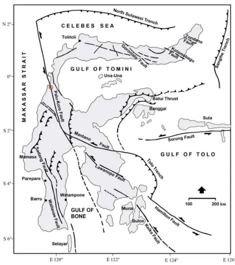
In this study, we estimated predominant period of an H/V spectrum in Palu City, Indonesia, by using microtremor single station observations. Sulawesi Island, eastern Indonesia, is located at the junction between the converging Pacific-Philippine, Indo-Australian Plates and the Eurasian Plate. One of the major structures in Central Sulawesi is the Palu-Koro Fault system, which extends NNW-SSE direc-tion and cross-cuts Sulawesi along more than 300 km from the North Sulawesi trench passing south-ward through Palu Bay then turn to the southeast, connecting to the Matano and Lawanopo Faults and further eastward both faults join to Tolo trench. Sev-eral earthquakes have been known along Palu-Koro Fault system such as Gimpu earthquake (1905), Ku-lawi earthquake (1907), Kantewu earthquake (1934), and offshore Donggala earthquake (1968) which caused tsunami that destroyed 800 houses and killed 200 people at Donggala district. Palu City, located at the northern tip of Palu depression, is a capital of the Central Sulawesi Province. It is located in the active seismic zone of the Palu-Koro fault. Spec-tral ratios for horizontal and vertical motion (H/V) from single-station microtremor records were used to identify the predominant periods of the ground
vi-∗Corresponding author: P. S. THEIN, Department of
Geological Engineering, Faculty of Engineering, Gadjah Mada University, Jl. Grafika 2 Yogyakarta, 55281, Indone-sia. E-mail: [email protected]
brations. Understanding the parameters of predom-inant period[s] and seismichazard is important for mitigation and environmental planning of the Palu region.
Keywords: H/V spectrum, predominant period[s], microtremor single station observation
1 Introduction
THEIN,et al.
Figure 1: Tectonic map of Sulawesi (Priadi, 1993). Red circle: Palu depression area.
1968. The last earthquake with the focal depth of 23 km caused tsunami wave up to 10 m high. It has destroyed 800 houses and killed 200 peo-ple at Donggala district.
City of Palu, located at northern tip of Palu depression, is a capital of the Central Sulawesi Province. As a capital of province, Palu will be a center of development where popula-tion growth by urbanisapopula-tion usually increases rapidly. Considering the seismic activity along the Palu-Koro fault zone, understanding the parameters of predominant periods and seis-michazard is important for mitigation and environmental planning.
In recent years, microtremor observations have become popular for the purpose of inves-tigating soil structure because they do not re-quire much manpower and cost. Microtremor is a small ground vibration excited by artificial sources or natural phenomena such as factories, traffic, wind, waves, etc. As the vibration prop-agates through the ground surface, the surface waves such as the Rayleigh and Love waves are dominant.
In this study, Palu, where a large earthquake
be a target area. We carried out higher den-sity single-point observations. Based on the ob-served data, we calculated the distribution of predominant Rayleigh wave.
2 Geometry of Palu depression
Geometry of the northern part of Palu-Koro Fault system shows an asymmetric graben called Palu depression which is up to 7 km wide bordered by N-S orientation, up to 60 m high steep triangular facets and truncated al-luvial fans at West side, and gently step faults at East side along approximately 20 km length from Palu bay to the north and Gumbasa valley to the south.
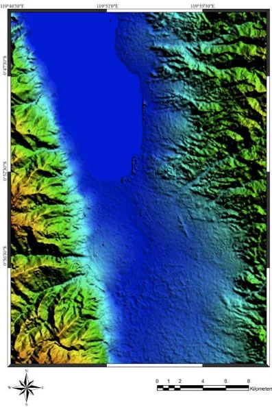
The topography of the Palu region in detail become firstly important to observe and to ana-lyze. Topographic map of 1:50000 scale and dig-ital elevation model (DEM) from SRTM with 30 m resolution can be combined in order to deter-mine structural lineaments (Figure 3).
3 Microtremor single station observa-tions
A microtremor is a very small ground motion that can be recorded on the ground surface. It can be produced by a variety of excitations (eg., wind, traffic, breaking sea waves), A full mi-crotremor record can be described by one ver-tical and two horizontal components. Our anal-ysis was conducted by using the recorded mi-crotremor. First, the horizontal and vertical spectrum ratios (HVSR) were computed for all of the observation sites. The peak period of the HVSR is known to correspond to the resonant period of the site.
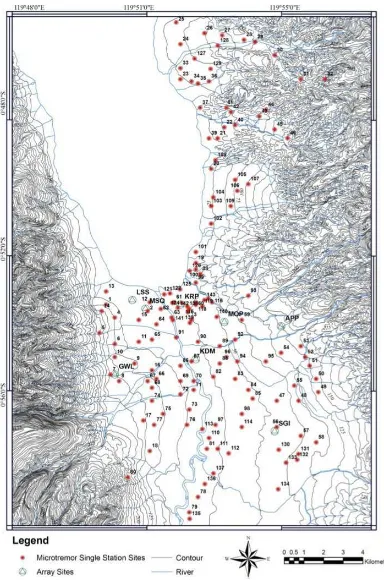
A three-component accelerometer with GPL-6A3P data logger (produced by Akashi Co. Ltd.) was used. The number of single-point observations was 151 (Figure 4). The sampling frequencies were 100 Hz or 500 Hz and the ob-servation times were 10 to 15 minutes.
4 Predominant period of H/V spectra
THEIN,et al.
THEIN,et al.
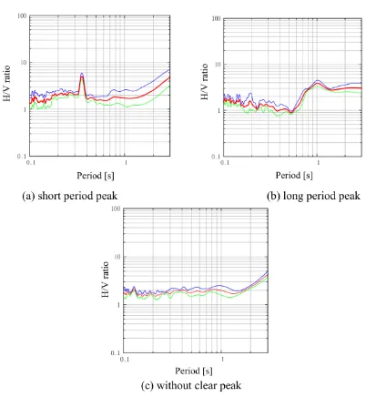
called the H/V spectrum. The predominant pe-riod of an H/V spectrum is thought to be equiv-alent to the predominant period of the ground directly beneath the site. H/V spectra at each site in the target area were calculated. We classi-fied the H/V spectra calculated into three types according to the shape of the spectra (Figure 5).
Type A: those with short period peak (Figure 5(a))
Type B: those with long period peak (Figure 5(b))
Type C: those without clear peaks (Figure 5(c))
Distinct peaks express layers characteristics in which the shear wave velocity is quite differ-ent. According to this interpretation, the lower and higher periods in Type A represent the ef-fects from deep and shallow soil layers, respec-tively. In Type B, the difference between the two layers is not marked and the effect of one layer is absorbed into that of the other layer. Type C is an observation site that has hard soil or did not work well. Thus, we established the data for both long and short predominant periods. Although the predominant period does not al-ways indicate the characteristics of an individ-ual layer because typically the actindivid-ual shaking mode of the ground is complex, we assumed that the long and short periods reflected infor-mation from each layer.
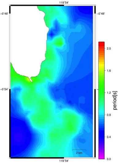
Although there are 151 observation points, the points are not adequate to cover all the tar-get area if each value of the predominant period obtained is considered to be a realization of a stochastic random field. Space interpolation is conducted by ordinary Kriging technique. The results are shown in Figure 6. The predominant periods of 1.5–2.0 seconds were on the alluvial fan area. The spatial correlations between pre-dominant periods on the Westside Mountain (which slope is steep) are shorter than those in the eastside mountain and change more rapidly.
5 Conclusions
Our observations and analysis provide useful and practical data for earthquake disaster
mit-conclusions obtained in this study area are as follows.
1. Microtremor observations were carried out for constructing a subsurface ground model in Palu. Single-point observations were conducted at 151 sites which covered almost the whole city area.
2. H/V spectra were calculated at all the single-observation sites and a distribution of predominant periods was obtained. 3. The Kriging method can be used for the
in-terpolation of subsurface information such as predominant period and shear wave ve-locity.
4. The predominant periods of 1.5–2.0 sec-onds were on the alluvial fan area.
Acknowledgements
This study was supported by the Grant-in-Aid of JICA/SEED-Net. We gratefully acknowledge Dr. Noguchi and Dr. Ono in Tottori Univer-sity, and Dr. Rusnardi Rahmat Putra in Ky-oto University for their cooperation with the microtremor observations. We sincerely thank Tadulako University for their help in undertak-ing the observations in Palu, Indonesia.
References
Aki, K. (1957) Space and time spectra of station-ary stochastic waves, with special referent to mi-crotremor. Bull. Earth. Res. Inst. 35(3), pp. 415-456.
Cho, I., Tada, T. and Shinozaki, Y. (2004) A new method to determine phase velocities of Rayleigh waves from microseisms. Geophysics, 69, pp. 1535-1551.Kiyono, J., Ono, Y., Sato, A., Noguchi, T. and Rusnardi, P. R, Estimation of subsurface structure based on Microtremor observations at Padang, Indonesia.
Kiyono, J. and Suzuki M. (1996) Conditional Simu-lation of Stochastic Waves by Using Kalman Fil-ter and Kriging Techniques. Proceedings of the 11th World Conference on Earthquake Engineer-ing, Acapulco, Mexico, Paper No. 1620.
THEIN,et al.
Institute of Earthquake Science, Seq. No. 26, pp. 1–16 (in Japanese).
Ono, Y., Kiyono. J., Rusnardi, P. R. and Noguchi, T. (2010) Microtremor observation in Padang city, Indonesia to estimate site amplification of seis-mic ground motion. Proceedings of International Symposium on a Robust and Resilient Society against Natural Hazards and Environmental Dis-asters and the third AUN/SEED-Net Regional Conference on Geodisaster Mitigation, pp. 386-391.
Priadi, B. (1993) Geochimie du magmatisme
de l’Ouest et du Nord de Sulawesi, Indone-sia: Tracage des sources et implications
geo-dynamique. Doctoral Thesis, UniversitePaul
Sabatier, Toulouse, France.