A New Calibration Method of Airborne Interferometric SAR
Mengmeng Wang a, Guoman Huang a
a
Chinese Academy of Surveying and Mapping 100830 Beijing [email protected]
KEY WORDS: synthetic aperture radar, interferometric calibration, 3D reconstruction model, sensitivity equations
ABSTRACT:
The accuracy of system parameters is one of the key factors that limit the precision of DEM from airborne dual-antenna InSAR, so the interferometric calibration is of great significance. The traditional calibration method establishes the sensitivity equations to solve the different calibration parameters biases. This paper presents a new calibration method to improve the algorithm stability and suit for mass production. It introduces sensitivity analysis of every interferometric parameter and establishes a new model based on sensitivity equations. Finally, a set of airborne interferometric SAR data are adopted to do the experiment to illustrate the availability of the new method.
1. INTRODUCTION
Interferometric synthetic aperture radar can generate Digital Elevation Models (DEM) with the phase differences calculated by two complex images. And the inaccurate system parameters may cause system errors in DEM . Often the man-made GCPs, usually corner reflectors, are used for interferometric calibration. The system requirements in both accuracy and stability can be resolved from the sensitive equations , as well as the calibration parameters that conclude the baseline length and angle, slant range and interferometric phase offset.
2. CALIBRATION
The sensitive equations derived by differentiating the basic location equation are always used for interferometric calibration. It establishes relations between system parameters and calibration standards. 2.1 3D Reconstruction Model
Range equations, Doppler equation and interferometric phase equation straightly show the relationship between its measurements and position of the ground points when InSAR was applied for terrain
mapping.
P − A = r (1)
λf = Ṗ−Ȧ ∙ P−A
|P−A | (2)
� = �� �−
= ���� [( − � ∙�� + �� ) − ] (3)
Foundation:National high technology research and
development program
(‘863 Program’) No.2011AA120402
International Archives of the Photogrammetry, Remote Sensing and Spatial Information Sciences,
Volume XL-7/W1, 3rd ISPRS IWIDF 2013, 20 – 22 August 2013, Antu, Jilin Province, PR China
Figure1. Two different coordinates and location geometry
Two different coordinate systems are used. The first one, vnw, is the MMC(Madsen Moving Cordinates) based on the aircraft. The second one, xyz, is the ECR coordinate system. Under the Figure 1, the target position, P, can be expressed by (4).
� = � + �̂ = � + [√ � � − ��
− �
] (4)
Depend on �̂ in ECR and the definition of �, , we can obtain the analytical solutions of target’s position.
θ = arccos cosθpcos θb+ θr+ θ (5)
Sensitivity equations are derived by differentiating the basic location with different interferometric parameters. In terms of zero-Doppler processing, the elevation error can be expressed as a linear function of those interferometric parameter errors.
=∂h∂b∆b +∂h∂α∆α +∂φ∂h∆φ +∂r∂h∆r (8)
2.3 Calibration based on New Method
When we solve system calibration parameters by traditional algorithm with least square method, the sharp sensitive differences between those parameters lead to the ill-conditioned sensitivity matrix with poor stability and convergence. So, small random error would have an apparent influence on result of parameter biases. Besides, all the traditional calibration methods consider phase error as a constant, while phase error is closely related to the range and azimuth position, aircraft attitude, image focus and so on. So, if we assume phase error varies with position of GCP, we can construct a new model:
∆�= ∙∆ + ∙ ∆ (14) Where = the sensitive matrix consisted of
first-order derivative of baseline length and angle, slant range
∆ = [∆ , ∆ , ∆ ]�
∆ = [∆� , ∆� , ⋯ , ∆��]�
= � � (�� | ,�ℎ �� | , ⋯ ,�ℎ �� |�ℎ �)
And (14) can be written as follows.
[ ] [∆∆ ] = ∆� 5
Because the sensitivity matrix is rank deficient, we can get the only minimum least square solution without iteration based on the Moore-Penrose generalized inverse matrix from SVD deposition.
3. RESULTS WITH AIRBORNE DATA
In order to validate the proposed calibration method, we use CASMSAR-X data for experiment. CASMSAR is the airborne SAR system developed by International Archives of the Photogrammetry, Remote Sensing and Spatial Information Sciences,
Volume XL-7/W1, 3rd ISPRS IWIDF 2013, 20 – 22 August 2013, Antu, Jilin Province, PR China
China Academy of Surveying and Mapping and other institutions, which installs double HH polarized antennas of X band and single full polarization antenna of P band. Table 1 shows the system parameters of CASMSAR platform.
Table 1. Aircraft system parameters
Parameters Value parameters. And Figure 3 show the calibration results of two algorithms.
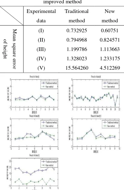
Table 2. Comparison between traditional method and improved method
Figure 3. Results of two algorithms
When mean square error of whole image height is relatively poor, compared with traditional method, the proposed method can improve the imaging accuracy and get better DEM. The opposite happens (about 1m), new method can get about the same accuracy of height as traditional method. Aiming at gross error appearing in traditional algorithm, proposed algorithm has better stability and gets better DEM as shown by table 2, where data (V) has poor quality echo signal.
4. SUMMARY
A new calibration method to accurate interferometric parameters has been presented and the capability of the approach was demonstrated with airborne InSAR data. By using every GCP’s phase error estimation, proposed approach can improve the algorithm stability and suit for mass production without iteration. This paper also pointed out that phase error is related to aircraft attitude, imaging geometry model, motion compensation algorithm and so on. In the following attention should be directed to use GCPs’ phase error fitting full image’s phase biases.
REFERENCES
Dall J, Christensen E L, 2002. Interferometric Calibration with Natural Distributed Targets. 2002 IEEE International Geoscience and Remote Sensing Symposium, Toronto, pp.170-172.
Jordi J. Mallorqui, Marc Bara, Antoni Broquetas,2000. Sensitivity Equations and Calibration Requirements on Airborne Interferometry. Proceedings of the IEEE 2000 IGRASS, Honolulu, pp. 2739-2741.
Li Pin, 2008. Research on Calibration Method for InSAR system. Beijing: University of Science and Technology of China.
Mallorqui J J, Bara M, Broquetas A, 2000. Sensitivity Equations and Calibration Requirements on Airborne Interferometry. IEEE 2000 International Geoscience and Remote Sensing Symposium, Honolulu, pp.2379-2741.
Mallorqui J J, Rpsado I, Bara M, 2001. Interferometric Calibration for DEM Enhancing and System Characterization in Single Pass SAR Interferometry. IEEE 2001 International Geoscience and Remote Sensing Symposium, Sydney, pp.404-406.
International Archives of the Photogrammetry, Remote Sensing and Spatial Information Sciences,
Volume XL-7/W1, 3rd ISPRS IWIDF 2013, 20 – 22 August 2013, Antu, Jilin Province, PR China
S. N. Madsen, H. A. Zebker and J. Martin, 1993. Topographic mapping using radar interferometry: proceedings techniques. IEEE Trans. on Geosci. Remote Sens., 31(1): 246-256.
Wang Yanping, 2003. Studies Model and Algorithm for Airborne Interferometric SAR. Institute of Electronics Chinese Academy of Science.
International Archives of the Photogrammetry, Remote Sensing and Spatial Information Sciences,
Volume XL-7/W1, 3rd ISPRS IWIDF 2013, 20 – 22 August 2013, Antu, Jilin Province, PR China