The 1st International Symposium on LAPAN-IPB Satellite (LISAT)
for Food Security and Environmental Monitoring
Guest Editors:
Yudi Setiawan, Muhammad Irfansyah Lubis, Lilik Budi Prasetyo,
Iskandar Zulkarnain Siregar and Hefni Effendi
Available online at www.sciencedirect.com
ScienceDirect
Procedia Environmental Sciences
Vol.
24
(
2015
)
1
–
340
doi:10.1016/S1878-0296(15)00117-6
Procedia Environmental Sciences 10 (2011) iii–viiProcedia Environmental Sciences 24 (2015) iii–iv
Contents
Editorial
Editorial
Y. Setiawan, M.I. Lubis, H. Effendi, L.B. Prasetyo, I.Z. Siregar . . . 1
Agriculture
Landuse Conversion Impact Assessment on Landscape Provisioning Service for Rice Suffi ciency in Langkat Regency, Indonesia
D.R. Siagian, T. Marbun, C. Hermanto, A.J. Alcantara . . . 3 Spatial Modelling for Food Vulnerability Using Remote Sensing Data and GIS (Study Case in Klungkung Regency, Bali)
D.S. Ratnasari, P. Kusumawardani . . . 15 Constraints of VSWI in the Estimation of Drought Extent Using Landsat Data: A Case of Tuban, Indonesia
B.H. Trisasongko, D.R. Panuju, D. Shiddiq, L. Ode S. Iman, R.I. Sholihah, S. Kusdaryanto . . . 25 Applicability of Satellite Remote Sensing for Mapping Hazardous State of Land Degradation by Soil Erosion on Agricultural Areas
S. Uchida . . . 29 Land Suitability for Agrotourism Through Agriculture, Tourism, Beautifi cation and Amenity (ATBA) Method
Kaswanto . . . 35 The Leaf Color Performance on Several Lines of Cassava and its Relation with Tuber Yield as Early Reference
N. Khumaida, S. Maharani, S.W. Ardie . . . 39 Numerical Classifi cation, Subak Zoning and Land Transfer Function Rice Field in the Province of Bali Based on Remote Sensing and GIS
I. Lanya, N.N. Subadiyasa, K. Sardiana, Gst. P. Ratna Adi . . . 47
Climate
Monitoring and Prediction of Hydrological Drought Using a Drought Early Warning System in Pemali-Comal River Basin, Indonesia
W. Hatmoko, Radhika, B. Raharja, D. Tollenaar, R. Vernimmen . . . 56 Simulation of Forest Fires Smoke Using WRF-Chem Model with FINN Fire Emissions in Sumatera
D.E. Nuryanto . . . 65 Rainfall Simulation Using RegCM4 Model in Kalimantan during El Nino Southern Oscillation
E.Y. Arini, R. Hidayat, A. Faqih . . . 70 The Detection of Urban Open Space at Jakarta, Bogor, Depok, and Tangerang – Indonesia by Using Remote Sensing Technique for Urban Ecology Analysis
A.F.M. Zain, P.A. Permatasari, C.N. Ainy, N. Destriana, D.F. Mulyati, S. Edi . . . 87
Forestry
Spatial Distribution Model of Stopover Habitats Used by Oriental Honey Buzzards in East Belitung Based on Satellite-tracking Data
A. Mardiyanto, Syartinilia, A.D.N. Makalew, H. Higuchi . . . 95 Landscape Modeling for Human – Sulawesi Crested Black Macaques Confl ict in North Sulawesi
B. Nailufar, Syartinilia, D. Perwitasari . . . 104 Forecasting Simulation of Smoke Dispersion from Forest and Land Fires in Indonesia
E. Heriyanto, L. Syaufi na, M. Sobri . . . 111 Classifi cation Rules for Hotspot Occurrences Using Spatial Entropy-based Decision Tree Algorithm
I.D. Nurpratami, I.S. Sitanggang . . . 120 A Geographic Information System for Hotspot Occurrences Classifi cation in Riau Province Indonesia
K. Amri, I.S. Sitanggang . . . 127 Hotspot Distribution Analyses Based on Peat Characteristics Using Density-based Spatial Clustering
M. Usman, I.S. Sitanggang, L. Syaufi na . . . 132 Indicator Determination of Forest and Land Fires Vulnerability Using Landsat-5 TM data (Case Study: Jambi Province)
A. Nurdiana, I. Risdiyanto . . . 141 Estimating Distribution of Carbon Stock in Tropical Peatland Using a Combination of an Empirical Peat Depth Model and GIS
Rudiyanto, B.I. Setiawan, C. Arief, S.K. Saptomo, A. Gunawan, Kuswarman, Sungkono, H. Indriyanto . . . 152 Infl uence the Existence of the Bali Botanical Garden for Land Cover Change in Bedugul Basin Using Landsat Time Series
R. Iryadi, M.N. Sadewo . . . 158 Geospatial Approach for Ecosystem Change Study of Lombok Island under the Infl uence of Climate Change
S. Sapta, B. Sulistyantara, I.S. Fatimah, A. Faqih . . . 165
Available online at www.sciencedirect.com
Driving Force Analysis of Landuse and Cover Changes in Cimandiri and Cibuni Watersheds
B.W. Aroengbinang, Kaswanto . . . 184 Identifying Change Trajectory over the Sumatra’s Forestlands Using Moderate Image Resolution Imagery
Y. Setiawan, M.I. Lubis, S.M. Yusuf, L.B. Prasetyo . . . 189 Expansion of Oil Palm Plantations and Forest Cover Changes in Bungo and Merangin Districts, Jambi Province, Indonesia
S.D. Tarigan, Sunarti, S. Widyaliza . . . 199 Understanding Landscape Change Using Participatory Mapping and Geographic Information Systems: Case Study in North Sulawesi, Indonesia
M.I. Lubis, J.D. Langston . . . 206
Marine & Fisheries
Random Forest Classifi cation for Mangrove Land Cover Mapping Using Landsat 5 TM and ALOS PALSAR Imageries
R. Jhonnerie, V.P. Siregar, B. Nababan, L.B. Prasetyo, S. Wouthuyzen . . . 215 Object-based Image Analysis for Coral Reef Benthic Habitat Mapping with Several Classifi cation Algorithms
N. Wahidin, V.P. Siregar, B. Nababan, I. Jaya, S. Wouthuyzen . . . 222 Water Quality Status of Ciambulawung River, Banten Province, Based on Pollution Index and NSF-WQI
H. Effendi, Romanto, Y. Wardiatno . . . 228 Fisheries Survey in Mentawai Waters Bengkulu Province
M.M. Kamal, H. Effendi, S.P. Nugroho . . . 238
Satellite Technology
The Potential of UAV-based Remote Sensing for Supporting Precision Agriculture in Indonesia
C.A. Rokhmana . . . 245 Gemini Virus Attack Analysis in Field of Chili (Capsicum Annuum L.) Using Aerial Photography and Bayesian Segmentation Method
M. Solahudin, B. Pramudya, Liyantono, Supriyanto, R. Manaf . . . 254 Multi-copter Development as a Tool to Determine the Fertility of Rice Plants in the Vegetation Phase Using Aerial Photos
P.P. Rizky Aidil, Liyantono, M. Solahudin . . . 258 Preliminary Study of Bridge Deformation Monitoring Using GPS and CRP (Case Study: Suramadu Bridge)
H.H. Handayani, Yuwono, M. Taufi k. . . 266 Spatial Online Analytical Processing for Hotspots Distribution Based on Socio-economic Factors in Riau Province Indonesia
P. Thariqa, I.S. Sitanggang . . . 277 The Analysis of LAPAN-A3/IPB Satellite Image Data Simulation Using High Data Rate Modem
C.T. Judianto, E.N. Nasser . . . 285 The Utilization of Global Digital Elevation Model for Watershed Management a Case Study: Bungbuntu Sub Watershed, Pamekasan
M. Taufi k, Y.S. Putra, N. Hayati . . . 297 Geomorphology Analysis of Lava Flow of Mt. Guntur in West Java Using Synthetic Aperture Radar (SAR) with Fully Polarimetry
L.D. Handayani, B.H. Trisasongko, B. Tjahjono . . . 303 Reduction of High Purity Silicon from Bamboo Leaf as Basic Material in Development of Sensors Manufacture in Satellite Technology
Aminullah, E. Rohaeti, Irzaman . . . 308 Development of Near-real time Forest Monitoring (Phase I: Data Preparation)
Y. Setiawan, Kustiyo, A. Darmawan . . . 317 Characterizations of Electrical and Optical Properties on Ferroelectric Photodiode of Barium Strontium Titanate (Ba0.5Sr0.5TiO3) Films Based on the Annealing Time Differences and its Development as Light Sensor on Satellite Technology
J. Iskandar, H. Syafutra, J. Juansah, Irzaman . . . 324 Development of Lithium Tantallite (LiTaO3) for Automatic Switch on LAPAN-IPB Satellite Infra-red Sensor
A. Ismangil, R.P. Jenie, Irmansyah, Irzaman . . . 329 Development and Application of Ba0.5Sr0.5TiO3 (BST) Thin Film as Temperature Sensor for Satellite Technology
Procedia Environmental Sciences 24 ( 2015 ) 317 – 323
1878-0296 © 2015 The Authors. Published by Elsevier B.V. This is an open access article under the CC BY-NC-ND license
(http://creativecommons.org/licenses/by-nc-nd/4.0/).
Selection and peer-review under responsibility of the LISAT-FSEM Symposium Committee
doi: 10.1016/j.proenv.2015.03.041
Available online at www.sciencedirect.com
ScienceDirect
The 1st International Symposium on LAPAN-IPB Satellite for Food Security and Environmental
Monitoring
Development of near-real time forest monitoring (Phase I: Data
preparation)
Yudi Setiawan
a,*, Kustiyo
b, Arief Darmawan
caCenter for Environmental Research, Bogor Agriculutral University, Kampus IPB Darmaga, Bogor, 16680, Indonesia bDeputy for Remote Sensing Affair, Indonesian National Institute of Aeronautics and Space (LAPAN), Pekayon, Jakarta, 13710, Indonesia
cREDD+ Agency of Republic of Indonesia, Mayapada Tower II Lt. 14, Jl. Jenderal Sudirman Kav. 27, Jakarta, 12910, Indonesia
Abstract
Deforestation and forest degradation are still major problems in Indonesia, even though the magnitude has been decreasing recently. In order to overcome these problems, an immediate action with accurate and up-to-date information is essensial. Expired information, due to out of date is usually hamper the immediate response. Remote sensing technology seems to be a powerful tool to monitor the change of forest cover. However, an availability of cloud free satellite images in tropical region is another of obstacle. Regarding to the deforestation and forest degradation issues, it needs to develop near-real time forest monitoring, that publicly available to support the transparency in managing the natural resources. As an initial work of the development of early deforestation detection system, we employed the long-term MODIS image datasets, acquired from 2001 to 2013 with 286 time series data totally. Although MODIS data have some advantages in providing basic information related to the real time change detection, these time-series data inevitably contain disturbance caused by atmospheric variability and aerosol scattering. This study is an early phase in developing the near-real time forest monitoring system, which is focused on providing a reliable image datasets to support this system. The results suggested that MODIS data offer great opportunities to support the near-real time forest monitoring system at large scale.
© 2015 The Authors. Published by Elsevier B.V.
Selection and peer-review under responsibility of the LISAT-FSEM Symposium Committee.
Keywords: Near-real time monitoring; forest cover; MODIS; Indonesia
* Corresponding author. Tel.:+62-251-8621262; fax: +62-251-8622134.
E-mail address: [email protected]
© 2015 The Authors. Published by Elsevier B.V This is an open access article under the CC BY-NC-ND license (http://creativecommons.org/licenses/by-nc-nd/4.0/).
Monitoring, Reporting and Verification (MRV) as well as Moratorium work stream of the Reducing Emissions from Deforestation and Forest Degradation Plus, Agency of Republic of Indonesia (BP-REDD+) is mandated to handle the process of national and nested sub-national REDD+ measurement and reporting (MR) system in accordance with IPCC Good Practice Guidance. The REDD+ MRV and Moratorium will establish a multi-tiered measurement system. Viewed this way, it is urgently need to develop a near-real time deforestation detection system that provides important information in Monitoring, Reporting and Verification (MRV) that should be the main responsibility of BP-REDD+ agency (President Decree No. 62/2013). In this context, accurate and up-to-date information is required immediately.
Remote sensing technology seems to be a powerful tool to monitor the forest cover changes continuously in terms of space and time. To support the MRV system, application of high-temporal satellite imagery in a large scale will provide accurate, sufficient, and significant information regarding to the deforestation events [1], and it is
possible to develop the near-real time deforestation detection system especially for Indonesia’s forest land.
Regarding to the forest cover change, the monitoring of vegetation dynamics continuously of land surface is increasingly essensial and it is a way to detect a rapidly forest cover changes. Vegetation dynamics monitoring system have attracted attention as it provides a better understanding of land changes, including the forestlands [2]. Characterization of vegetation dynamics of forestlands has often been made using vegetation index values [e.g.: 3,1]. The temporal dynamics of those index values are useful in detecting the forest cover changes and their distributions [4].
Although MODIS data have some advantages in providing basic information related to vegetation dynamics, time-series of these data inevitably contain disturbances caused by atmospheric variability [5] and aerosol scattering [6]. Such noise degrades the data quality and introduces considerable uncertainty in temporal sequences, complicating the analysis by introducing significant variations in time series data. Therefore, noise reduction or fitting a model to data observation is needed before use it to detect the vegetation cover change in the forestlands.
Various strategies for image preprocessing have been applied such as: polynomial and median filters [7], a moving window to select the local maximum VI [8], Temporal Window Operation/TWO [9], logistic curve fitting [10], the asymmetric Gaussian function fitting approach [11], Principal Component Analysis /PCA [12], and the Savitzky-Golay filter approach [13]. Several spectral-frequency techniques have also been used, including Fourier-based fitting methods for separating the high-frequency components of noise and the low-frequency components of seasonal changes of VI [1]. In addition, wavelet decomposition that has been used recently to characterize crop penology [14], to determine changes in the expansion and intensification of crops [2] as well as to investigate vegetation dynamics in terrestrial ecosystem [15]. In this study, two filtering approaches are applied to MODIS time-series datasets based on a median moving window and linear interpolation to smooth and reduce the discontinuous/sharp spike data of the datasets.
The main objective of this study is to provide a reliable datasets in order to support the developing of early
warning system for deforestation by using remote sensing technology for Indonesia’s forestland with high accuracy
results in accordance with the MRV program of BP-REDD+.
2.Methodology
2.1.Satellite Images
2.2.1. MODIS
MODIS has a viewing swath width of 2,330 km and covers the entire surface of the earth every one or two days. The data is acquired at 36 spectral bands in three spatial resolutions of 250m, 500m, and 1,000m. As a result, a lot of information related to the features of the land, oceans and atmosphere have been derived from MODIS data and have been used for studies of the processes and trends either for local or global scales [16].
MODIS surface reflectance includes band 1 to 7 that has 0.648 Pm, 0.858 Pm, 0.470 Pm, 0.555 Pm, 1.240 Pm,
1.640 Pm, and 2.13 Pm of specral reflectance. These datasets are the input for all of the MODIS land products, such
319 Yudi Setiawan et al. / Procedia Environmental Sciences 24 ( 2015 ) 317 – 323
of these reflectance products depend directly on the quality of atmospheric conditions. Therefore, the atmospheric correction algorithm needs to be applied to the data in order to correct the effects of gaseous, aerosol scattering as well as adjacency effects caused by variation of land cover, Bidirectional Reflectance Distribution Function (BRDF), atmosphere coupling effects, and contamination by thin clouds.
2.2.2. LANDSAT
Landsat imagery is used to examine the details of forest cover changes. The spatial resolution of 30 m is adequate to determine the changes and it is large enough to cover the change on MODIS image pixels. Landsat 5 TM, Landsat 7 ETM and Landsat 8 are available for those purposes.
2.2.Deforestation Indices
The daily MODIS-surface reflectance product is provided by the U.S. Geological Survey, Land Processes Distributed Active Archive Center (USGS LPDAAC). The dataset is distributed in GeoTIFF (Georeferenced Tagged Image File Format) and its coordinate system is geographic coordinate systems (GCS) on datum World Geodetic System of 1984 (WGS-1984). In this dataset, to select the best surface reflectance value, MODIS band quality
ratings is applied to retain only pixels rated as “acceptable” that would be used in the analysis.
The MODIS surface reflectance has 3 spectral bands which are red (band 1), near infrared/NIR (band 2) and shortwave infrared (band 6) spectral wavelengths. These bands provide the characterization of the main vegetation
properties. For instance, the red reflectance (615–700 nm) is reduced by the chlorophyll absorption and the near
infrared reflectance (772–892 nm) reaches a maximum for fully developed healthy canopies due to high light
scattering. From these two spectral ranges, the activity of vegetation is evidenced.
(1) Normalize Difference Vegetation Index (NDVI) is commonly used to measure the reliability of spatial and temporal inter-comparison of terrestrial photosynthetic activities. In other words, it is a measure of vegetation greenness. The NDVI is defined by the equation:
(1)
Where U*NIR and U*RED are the remote sensing reflectance of the vegetation in near infrared and red portion of the
spectrum, respectively.
(2) Open Area Index (OAI). The capability of OAI to detect open area is based on the comparison between shortwave infrared/SWIR (1600 nm) and NIR (800 nm) spectral band, which are sensitive to bareland as well as liquid water thickness. For this reason, the NIR/SWIR indices, such OAI, is proposed to detect forest cover change. The OAI is defined by the equation:
(2)
Where U*SWIR and U*NIR are the remote sensing reflectance of the vegetation in shortwave infrared and near infrared
portion of the spectrum, respectively.
2.3.Image Pre-processing
At regional scale, MODIS time series images are essential to recognize the forest cover change in much finer temporal resolution; consequently it should be possible to provide broad scale data to detect the occurrence of deforestation rapidly as an early warning forest detection system (near-real time detection). However, these time-series datasets are inevitably contain disturbances caused by cloud presence, atmospheric variability, and aerosol
composited 30-days), two filtering approaches were applied by:
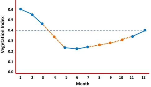
(1) A median moving window over 3 time series data in order to smooth and reduce the discontinuous/sharp spike data of MODIS time series (Fig 1),
(2) A linear interpolation to estimate unknown values caused by cloud. Linear interpolation is the simplest method of getting values at positions in between the data points (Fig 2).
Once these filtering applied on the temporal vegetation pattern, the vegetation pattern can be defined more clearly. These images are then clipped to cover only Indonesia area and sequentially stacked to produce the NDVI and OAI time-series datasets. Accordingly, the surface can be characterized by regular NDVI and OAI sequence at 12 time series per year.
Fig 1. Illustration of average moving window over 3 time series datasets following the average/median of datasets
Fig 2. A linear interpolation to estimate unknown values caused by cloud
As the main datasets, MODIS image processing is designed to achieve the analysis of continual vegetation patterns, and to detect their changes on forest cover areas, which is classified as deforestation.
3.Results and Discussion
3.1.Image Filtering
321 Yudi Setiawan et al. / Procedia Environmental Sciences 24 ( 2015 ) 317 – 323
In terms of a reference datasets of forest cover change [17], those changed area can be identified by characterizing the dynamics change of land cover. For example as mentioned in Fig 5., information that could be obtained from the vegetation dynamics analysis and forest cover change by the natural phenomena such as forest fire.
Figure 3. Vegetation dynamics pattern of an original EVI data and de-noising result (filtered signal)
Figure 4. a) Image before and b) after transformation.
Based on the trial application of vegetation pattern change analysis, this approach is able to detect not only several trajectories/patterns of vegetation or non-vegetation transformation, but also able to identify and monitore the re-vegetation process of non-vegetation area. Even if those changed areas smaller than the area extent indicated in the field due to the inability of MODIS data to resolve an area less than 6.25 ha (250 m x 250 m).
a)
b)
actual time of the forest cover change events and in monitoring the vegetation growth process. However, such capabilities are limited by the spatial resolution of the data. The use of multi-temporal data sets and change thresholds will be necessary to develop methodologies that utilize information on inter-annual variations in order to increase the accuracy of the near-real time system of detecting the deforestation.
Fig 5. Images indicate an event of a vegetation cover change by forest fire occurred on 2002.
4.Conclusions
This study is an early phase in developing the near-real time forest monitoring system, which is focused on providing a reliable image datasets to support the system. The two filtering approaches by a median moving window and interpolation were applied into MODIS datasets to filter out some noises. The filtered MODIS could be used to determine the change event of the lands, including the deforestation.
The methodology proposed in this study provides sufficient and useful information in monitoring the vegetation changes; this includes the location, time and trajectories of the changes. Consequently, it should be possible to provide data on the deforestation and forest degradation in broad scale especially for Indonesia context.
However, the mixed pixel issue is quite problematic in using MODIS datasets, the results show that the characterizing vegetation dynamics is an alternative approach to develop the near-real time forest monitoring system.
Acknowledgements
323 Yudi Setiawan et al. / Procedia Environmental Sciences 24 ( 2015 ) 317 – 323
References
1. Lunetta RS, Knight JF, Ediriwickrema J, Lyon JG, Worthy LD. Land-cover change detection using multi-temporal MODIS NDVI data.
Remote Sensing of Environment 2006; 105: 142-54.
2. Galford GL, Mustard JF, Melillo J, Gendrin A, Cerri,CC, Cerri, CE. Wavelet analysis of MODIS time series to detect expansion and intensification of row-crop agriculture in Brazil. Remote Sensing of Environment 2008; 112,: 576-87.
3. Knight JF, Lunetta RS, Ediriwickrema J, Khorram S. Regional scale land cover characterization using MODIS-NDVI 250 m multi-temporal imagery: A phenology-based approach. GIScience & Remote Sensing 2006; 43: 1-23.
4. Hansen M, Defries RS, Townshend J, Sohlberg R. Global land cover classification at 1 km spatial resolution using a classification tree approach. International Journal of Remote Sensing 2000; 21: 1331-64
5. Huete AR, Liu HQ. An error and sensitivity analysis of the atmospheric- and soil-correcting variants of the NDVI for the MODIS-EOS.
IEEE Transactions on Geoscience and Remote Sensing 1994; 32: 897-905.
6. Xiao XM, Braswell B, Zhang QY, Boles S, Frolking S. Sensitivity of vegetation indices to atmospheric aerosols: Continental-scale observations in Northern Asia. Remote Sensing of Environment 2003; 84: 385-92.
7. Van Dijk A, Callis SL, Sakamoto CM Decke WL. Smoothing vegetation index profiles: An alternative method for reducing radiometric disturbance in NOAA/AVHRR data. Photogrammetric Engineering and Remote Sensing 1987; 53: 1059-67.
8. Viovy N, Arino O, Belward AS. The best index slope extraction (BISE): A method for reducing noise in NDVI time-series. International Journal of Remote Sensing 1992; 13: 1585-90.
9. Park J, Tateishi R, Matsuoka M. A proposal of the Temporal Window Operation (TWO) method to remove high-frequency noises in AVHRR NDVI time series data. Journal of the Japan Society of Photogrammetry and Remote Sensing 1999; 38: 36-47.
10. Zhang X, Friedl MA, Schaaf CB, Strahler AH, Hodges JCF, Gao F, Reed BC, Huete A. Monitoring vegetation phenology using MODIS.
Remote Sensing of Environment 2003; 84: 471-5.
11. Johnson RD, Kasischke E. Change vector analysis: A technique for the multispectral monitoring of land cover and condition.
International Journal of Remote Sensing 1998; 19: 411-26.
12. Li Z, Kafatos M. Interannual variability of vegetation in the United States and its relation to el-nino southern oscillation. Remote Sensing of Environment 2000; 71: 239-47
13. Chen J, Jonsson P, Tamura M, Gu Z, Matsushita B, Eklundh L. A simple method for reconstructing a high-quality NDVI time-series dataset based on the Savitzky-Golay filter. Remote Sensing of Environment 2004; 91: 332-44.
14. Sakamoto T, Yokozawa M, Toritani H, Shibayama M, Ishitsuka N, Ohno H. A crop phenology detection method using time-series MODIS data. Remote Sensing of Environment 2005; 96 (3-4): 366 - 74.
15. Martinez B, Gilabert MA. Vegetation dynamics from NDVI time series analysis using the wavelet transform. Remote Sensing of Environment 2009; 113: 1823-42.
16. USGS LP DAAC. MODIS Data Pool. Accessed on 10 August, 2009 at https://lpdaac.usgs.gov/lpdaac/ get_data/data_pool.