Lithostratigraphy of Tabul Formation and Onshore Geology of Nunukan
Island, North Kalimantan
Salahuddin Husein*
Department of Geological Engineering, Faculty of Engineering, Gadjah Mada University, Yogyakarta, Indonesia
ABSTRACT. Nunukan Island is located in Northeast Kalimantan Basin, one of prolific basin in western Indonesia. However, this island lies in northern verge of the basin and hydro-carbon exploration were limited before the 1940s. No detail geological fieldworks has been published. This paper attempts to share geological information obtained from few acces-sible outcrops, particularly from the western part of the island where previous oil drilling were carried out. Most of the island have been built by Tabul Formation, which was also the main objective of reservoir for hydrocarbon exploration. It is composed of claystones, siltstones, and sandstones interbeds, deposited in transitional environment during Late Miocene. They exhibit coarsening upward sequence, the lower part composed of het-erolitic sandstones deposited in tidal flats, and the upper part composed of arkosic sand-stones deposited in distributary channels and mouthbars. The eastern coastal strip was constructed by Tarakan conglomerates, which have been deposited in fluvio-deltaic envi-ronment in Pliocene, unconformably over the Tabul clastics. Those Neogene deposition of paleo-Simengaris Delta apparently deformed and inverted in Plio-Pleistocene, contempo-raneously with basaltic volcanism which spread widely over northeastern Borneo, which also observed in the northern half of the Nunukan Island.
Keywords: Lithostratigraphy·Tabul Formation·Onshore geology·Hydrocarbon
explo-ration·Nunukan Island·Kalimantan.
1 INTRODUCTION
The Tabul Formation is one of main reservoir in Tarakan Basin, northeastern perimeter Kali-mantan. Their productive sand were proven during exploration in Bunyu Island, particu-larly in Tapa and Nibung fields, as well as in Sembakung Field in the mainland of North Kalimantan. However, this formation is not ex-posed in Bunyu Island, thus they were stud-ied exstensively in wells and subsurface logs. Instead, the Tabul Formation cropped consid-erably out on Nunukan Island, located 45 km in NNW direction from Bunyu Island (Figure 1). Yet only few attention have been paid to their occurrence on the Nunukan Island, and not any particular publication ever mentioned
*Corresponding author: S. HUSEIN, Department of Geological Engineering, Gadjah Mada Univer-sity. Jl. Grafika 2 Yogyakarta, Indonesia. E-mail: [email protected]
field study of the formation to date. This paper goes to presence field sedimentological obser-vation of Tabul Formation onshore of Nunukan Island, which considering regional tectonic his-tory and erosional intensity could be deliber-ately regarded as lower part of the formation. Along with field observation upon other rock formation in the island, a geologic synthesis is proposed, as an effort to elucidate geological history of the island.
2 GEOLOGICALSETTING
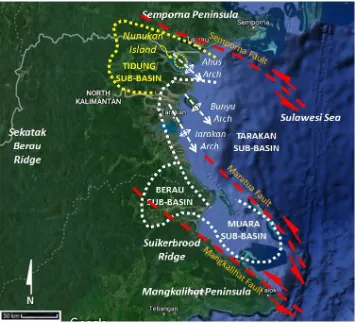
The Tarakan Basin is bounded to the north by Semporna Peninsula, to the west by Sekatak-Berau Ridge (which is part of Kuching High), to the south by Mangkalihat Peninsula, and to the east by deepwater of Sulawesi Sea (Achmad and Samuel, 1984).
Tectonically, the Tarakan Basin is bounded by two major NW–SE strike-slip sinistral faults, the Semporna Fault in northern margin and Mangkalihat Fault in the southern margin (Lentini and Darman, 1996). These strike-slip faults were interpreted to be responsible for several sub-parallel isoclinal arch structures in the Tarakan sub-basin, they are Tarakan Arch (±100 km length), Bunyu Arch (±40 km length) and Ahus Arch (±30 km length). The Tarakan and Bunyu arches host 92 % of all commercial hydrocarbon accumulations in the basin, and their plunging noses have been the target most of the offshore exploration effort (Wight et al., 1993). Nunukan Island itself is considered as northwest extension of Ahus Arch, separated by a small, intervening Pleis-tocene trough underlain by Pliocene below an angular unconformity, attesting to a major post-Pliocene orogeny. As located closer to the bounding fault of Semporna Fault, Tidung sub-basin was considered to be highly deformed, as Mio-Pliocene sequences were intensively eroded, widely exposing the Tabul Formation (Rosaryet al., 2014).
Achmad and Samuel (1984) divided the northern Tarakan sub-basins (Tidung and Tarakan) stratigraphy into 5 depositional cy-cles, intimately dictated by interplay between Kuching High episodic uplift as the clastic provenance and the regional eustasy. The first cycle was starting from regional transgression in the Late Eocene to Late Oligocene during deposition of Sujau clastics, Seilor carbonates, and Mangkabua marls. The second cycle took place during latest Oligocene to early Mid-dle Miocene, where Tempilan clastics interfin-gered with Tabalar limestones and overlaid by Naintupo shales. The third cycle occurred during Middle to Late Miocene, marked by tremendous supply of Meliat deltaic sediments followed by regressive clastics of Tabul and Santul. The fourth cycle was deposited during Pliocene by the occurrence of Tarakan deltaic sequences. The fifth cycle occured from early to
late Pleistocene by deposition of Bunyu deltaic succession during the on going sea-level rise.
B. Tabul Formation
The name Tabul was used by Dutch geolo-gists for the Middle to Late Miocene prograding deltaic sequences found in north Tidung sub-basin outcrops. They consists of sandstones, siltstones, claystones interbeds. Its type local-ity is located in Tabul River, Simengaris Estu-arine, where they were gently-dipping exposed for ~5 km length (Hidayat et al., 1995). How-ever, they were noted to be widely exposed and accessible in Nunukan Island. Wightet al. (1993) considered that Tidung Formation were deposited as initial sequences of Mio-Pliocene Simengaris Delta.
In Mandul Island, adjacent to Bunyu Island, this formation exposes and reached 1500 m thick, and tends to increase in thickness
east-ward (Achmad and Samuel, 1984).
Akuan-batinet al. (1984) reported the Tabul Formation reached 2000 m thickness subsurface in Bunyu Island, which was interpreted to be deposited in delta front to prodelta environment, with some limestone stringers observed as an indi-cation of marine transgression. In wells, they have coarsening upward characteristics, typical for prograding delta. Claystones range from 5 to 20 m in thickness, whilst sandstones is fine-grained and rarely reached 10 m thickness.
C. Hydrocarbon occurences and exploration It has been reported that two wells were drilled onshore Nunukan in 1939 (NNK-1) and 1942 (NNK-2) with hydrocarbon shows but further exploration was interrupted by World War II (Rosary et al., 2014). They were located on an-ticlinal crest in the western coast of island. Gas can still be found escaping from around well-head. Afterward, exploration focus has been concentrated in Tarakan sub-basin, particularly in the islands of Tarakan and Bunyu.
dis-Figure 1: Regional setting of Nunukan Island and Tidung sub-basin (image from GoogleEarth).
tal delta front and prodelta section (Akuanbatin et al., 1984). Interbedded shales provide good vertical seals.
The primary source rocks are moderately organic-rich shales and coals of the Mid-dle Miocene Meliat Formation and the Late Miocene Tabul Formation when depth of burial has been sufficient (Rosary et al., 2014). They were deposited in lacustrine, coastal plain and deltaic environments, and the organic matter is typically kerogen Type III of terres-trial origin. The kitchen area of the Tidung sub-basin is concentrated in the Sembakung-Bangkudulis graben. Intense oil generation was thought have been occurred since 3 Mya (Lower Pliocene) which were fully mature (Ro > 0.7) at 3200 to 3900 m depth (Rosary et al., 2014).
3 DATA ANDMETHODS
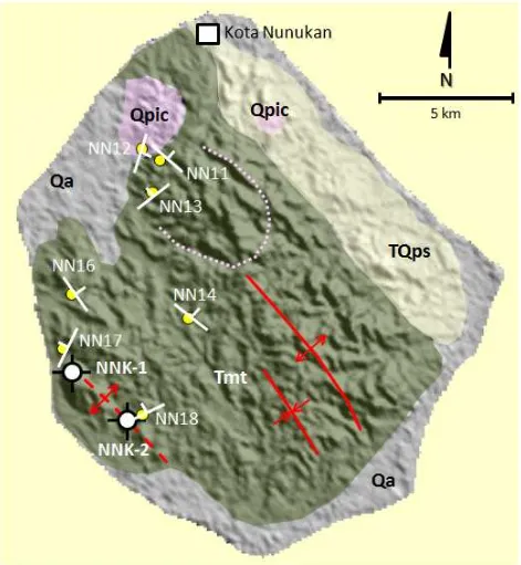
This paper is developed from geological field observation, where sedimentologic and strati-graphic data were obtained from 7 (seven) out-crops (Figure 2). Stratigraphic measured sec-tion was conducted in each outcrop, with a
scale of 1:100. Detail examination on sedimen-tary textures and structures, as well as paleon-tological evidences, were done on site. Geome-try and relationtship between each sedimentary bodies were also carefully noted.
Selection of outcrops considered the struc-tural condition of Nunukan Island. Tabul clas-tics covers ¾ of the island surface, and only in the eastern coastal strip they were covered by Tarakan conglomerates. Most of the out-crops dip to northeast, thus field survey was conducted from north part of island where the youngest section was located, to southwestern coast near the Nunukan-2 Well where the old-est section was placed.
4 RESULTS ANDDISCUSSION
A. Field sedimentological observation
Presentation of observation result is following depositional succession, from the oldest to the youngest. Lithofacies description are given and followed by their interpretative depositional environment.
NNK-2 well is composed of heterolithic sandstones with current ripples, interca-lated by shales which exhibit wavy ripples. Lateral accretions were plainly observed in sandstones (Figure 3a). Bioturbation was less intense, planolites only occurred in sandstones (Figure 3b). This outcrop is interpreted to be deposited in tidal flats, where sand flat recurrently covered by mud flat, suggesting few regressive breaks took place in esturine environment.
b. Outcrop NN.17 – Binusan (E 567304 – N 446026); this 6.5 m thick outcrop nearby NNK-1 well is composed of heterolithic sandstones, intercalated by shales. Sand-stones are characterized by bidirectional current ripples, whilst the overlying shales exhibit wavy ripples. The lower part con-sists of lenticular shales, gradually coars-ening and thickcoars-ening upward,to be dom-inated by fine-grained sandstones, which later gradually fining and thinning up-ward become lenticular shales. They are interpreted to be deposited in tidal flats, where sand flat were packed in between mud flats, suggesting transgressive break in estuarine environment.
c. Outcrop NN.16 – Binusan (E 567583 – N 448071); this 3 m thick outcrop is com-posed of fine-grained heterolithic sand-stones, intercalated by shales in flaser lami-nation. Both are having sharp contact, with sandstone surface exhibits current ripples. Sandstones were deposited in tidal channel environment, as indicated by channel fill, lateral accretion (Figure 4b), channel struc-tures (Figure 4a), and coarsening upward succession. Bioturbation were rare, mostly sub-horizontal of Planolites ichnofacies. d. Outcrop NN.14 – Binusan (E 571941 –
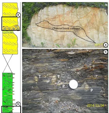
N 447189); this 12 m thick outcrop is con-structed by two contrasting sedimentary facies. The lower part is composed grey shales, characterized by lenticular lami-nation, and interpreted to be deposited in prodelta environment. They are interca-lated by fine-grained sandstones, exhibit current ripples, and oxidized at the sur-face. A handful horizontal bioturbation were observed, mostly belong to Cruziana ichnofacies (Figure 5b). The upper part of
outcrop is constructed by arkosic sand-stones, whitish yellow in appearance. They were deposited in low-angle trough cross-lamination structures, with organic material sheets covered the trough sur-face. These sandstones is interpreted to be deposited in distributary channels, as palpable lateral accretion, channel struc-tures, and channel-bank collapse (Figure 5a) were observed.
e. Outcrop NN.13 – Binusan (E 570515 – N 451780); this 6.5 m thick outcrop is lo-cated in Binusan City Forest, exposing a massive arkosic sandstones, pale yellow, with low-angle trough cross-bedded, and interpreted to be deposited in distributary channel environment.
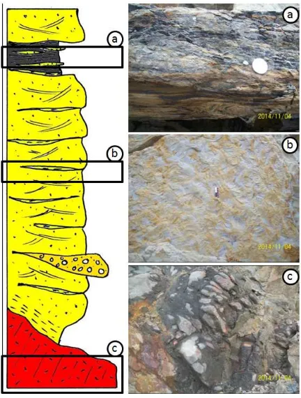
f. Outcrop NN.12 – Binusan (E 570182 – N 453434); this 20 m thick outcrop behind the military base of Kodim 0911/Nunukan (Figure 6), exposing arkosic sandstones, pale yellow, well-sorted, low-angle trough cross-bedded with lingoid current rip-ples at their surface (Figure 7b), intermit-tenly covered by clay-drapes and carbon flakes. Bedding surface often covered by hematite, which also frequently presents as iron nodule of various size. Liesegang structures gave reddish hue on the outcrop surface. This sandstone is interpreted to be deposited in distributary channel environ-ment. The upper part overlied by 1 m thick shales, dominated by lenticular structures with convolute in the basal part (Figure 7a) and capped by lignite, possibly deposited in crevasse splays. The lower section of outcrop was intruded by basalts (Figure 7c), with plagioclase phenocryst embed-ded in mafic groundmass. Their baking contact to sandstones altered the latter into kaolinite. Those Tabul clastics were cut by a ENE-WSW sinistral fault, dragged lignite layer into vertical dipping within its shear zone, suggesting a working NE-SW com-pressional stress (Figure 6). A sub-parallel normal fault is also present accompanying the strike-slip fault, suggesting a NW-SE extensional stress, possibly working as releasing phase after the compressional one.
– N 453042); this 15 m thick outcrop of arkosic sandstones containing well-rounded lithic fragments, pale yellow, low-angle trough cross bedded (Figure 8b) covered by clay drapes. Hematite layers occur in between bedding, often appear as iron nodules. Diagenetic structure of liesegang gave reddish hue on outcrop sur-face. These sandstones are interpreted to be deposited in distributary channels. The lower part of outcrop exposes grey shales, rich in carbon-flakes (organic materials), with few horizontal bioturbation (Figure 8c), possibly have been deposited in inter-distributary bay deposits. The sandstones intruded by basalts, possibly in shallow depth, as the appearance of columnar joints dominating the igneous rock body. The basalts exhibits plagioclase phenocryst embedded in mafic ground mass.
B. Lithostratigraphy of Tabul Formation on Nunukan Island
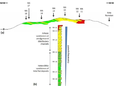
Distribution of observed lithologies are gener-ally dipping to northeast. A provisional geo-logic section for the western part of Nunukan Island was constructed in NE-SW direction, showing two main lithofacies of Tabul Forma-tion, intruded by one igneous rock unit (Fig-ure 9). The first unit, building the southwest-ern part of island, is composed of heterolithic sandstones which frequently intercalated by thick shales. The second unit, assembling the central part of island, is composed by arkosic sandstones, occasionally intercalated with thin shales. This latter rock unit was intruded by basalt.
The heterolithic sandstones, coarsening up-ward, mostly occupied by current ripples, occa-sionally herringbone structures were observed, and lateral accretion were clearly noticed. Or-ganic materials were abundant, entraped as carbon flakes deposited inside ripple troughs. Bioturbation were less intense, mostly dom-inated by Cruziana ichnofacies, indicating a low energy environment. These heterolithic sandstones are interpreted to be deposited in tidal flats within an estuarine environment, the lower part probably occurred during last stage of highstand sytem tract, whislt the upper part
Figure 4: (a) Channel-fill by flaser-laminated heterolithic sandstones, onlapped over channel bank (indicated by red arrows). Shale thickness varies, controlled by weight-loading of channel fills. (b) Lateral accretion (indicated by red ar-rows) as indication of channel migration, are well developed in flaser-laminated heterolithic sandstones.
Figure 5: (a) Arkosic sandstones, with channel-bank collapse, those composed of shale frag-ments. Lateral accretion suggests channel mi-gration to the north. (b) Grey shales interrupted by lateral bioturbation, mostly in 1 cm width, of Teichichnus (T) dan Planolites (P) species those belong toCruzianaichnofacies.
took place during the initial phase of falling stage sytem tract (Shanley and McCabe, 1984).
The arkosic sandstones, mostly composed of fine to medium grained quartz grains, with abundant well-rounded lithic fragments, de-posited by low-angle trough cross beds within lateral accretion packages, abut to channel structures. Clay drapes frequently cover bed-ding surface, incorporating carbon flakes. These amalgamated channel sandstones are interpreted to be deposited in distributary channels of upper delta plain. Intermittenly they are interupted by shales and lignite, those deposited in crevasse splays and flood plains. This succession was possibly deposited dur-ing the initial phase of lowstand system tract (Shanley and McCabe, 1984).
Wight et al. (1992) proposed that the de-position in Tidung sub-basin and the north-ern part of Tarakan sub-basin were carried out by paleo-Simengaris Delta. Thus the above mentioned facies changing of Tabul Formation on Nunukan Island reflects a dynamic inter-play between two major factors: the amount if silisiclastics sediments supplied by hinter-land through Simengaris River and the eu-static response of the basin. The former fac-tor in turn was defined by the rate of on-going regional tectonic uplift in Kuching High and river-channel switching, while the latter factor defined by the rate of basin subsidence and re-gional sea-level fluctuation. For those reasons, a hiatus was noticed to be occurred between the heterolithic sandstones unit and the arkosic sandstones, as they have a lacuna in their se-quential tracts, which were from initial phase of falling stage to initial phase of lowstand system.
Figure 6: A 20 m thick outcrop of Tabul sandstones, intruded by basalt. Two local faults were recognized and kinematically interpreted to be related with regional tectonic framework.
Figure 7: (a) Dark-grey shales, organic-rich, with basal convolute structures. (b) Lingoid current ripple marks on sandstone bedding sur-face, indicating high energy environment. (c) Basalt, grey and weathered.
Figure 9: (a) Exploratory geological cross section of the western part of Nunukan Island; depicting coarsening-upward lithofacies trend of Tabul Formation (b), and their relation to the basalt intru-sion.
Wight et al., 1992; Noon et al., 2003; Rosary et al., 2014).
The responsible tectonic inversion was taken place in Plio-Pleistocene, corresponding with the formation of Tarakan arches, including Ahus Arch in Tidung sub-basin (Akuanbatin et al., 1984; Wightet al., 1992; Lentini and Dar-man, 1996; Noonet al., 2003; Rosaryet al., 2014). Vitrinite reflectance, porosity and seismic data suggest 1000–1500 m of structural inversion occurred during arch formation (Lentini and Darman, 1996). Hitherto two mechanism for arch formation have been proposed. Most of geoscientists working in Tarakan Basin agreed with the main role of transpressional wrench of regional NW–SE major bounding strike-slip faults, i.e. Semporna, Maratua and Mangkali-hat faults (Lentini and Darman, 1996; Rosaryet al., 2014). Others apparently consent with deep thrust from west (Wightet al., 1992).
Those silisiclactic sequence of Tabul Forma-tion intruded by basalt (Figure 9). On geologi-cal map (Hidayatet al., 1995), the basalt intru-sion/volcanics expose in Kampung Baru (NE Nunukan) and Tanjung Batu (NW Nunukan).
Asmoro et al. (2016) added three others basalt outcrops at the mid part of island, i.e. Mam-bunut, Sei Apok, and Panamas. However, as those three basalt outcrops encircled a to-pographic high, author proposes those basalts probably belong to one larger subcropped ig-neous body that dictated the local morphology, which in Figure 2 is represented by a half-ring of pink dashed-line.
the Sulu Sea Plate as subducted slab (Castilloet al., 2007), or the on-going subducted Dangerous Ground Continental Plate (Wanget al., 2016).
Different interpretation was given by Macphersonet al. (2010) based on geochemical signatures and tomographic study, they pro-posed that the Plio-Pleistocene magmatism on Semporna Peninsula resulted from OIB (ocean island basalt)-like upwelling into lithospheric thin spots. Geodynamically, this interpretation requires a thinning transitional crust underly-ing the region, which have also been proposed by Hidayatiet al. (2007) and Salahuddin et al. (2011).
However, the role of Plio-Pleistocene mag-matism with the arch formation is poorly un-derstood and no research have address this matter yet. The proposed geological map de-picts the main igneous body lies in the mid of Nunukan Island, alongside with the crestal line of Nunukan Anticline (Figure 2). Then again, the presence of anticlinal structures were also indistinctly defined on the surface, a condition that was expected as the island sits on top of Arch structure. From the outcrop NN.12, the Tabul Formation was deformed by an E–W faults resulting from NE–SW compressional stress, which have been inferred to be derived from the sinistral movement of Semporna Fault, the northern bounding structure whose sup-posed to be responsible for arches formation. As those Tabul outcrop and their faults were cut by basalt, it is highly possible if the magma-tism occurred shortly after the faulting. At this point in time, it is quite remote to assume the diapiric magmatism had caused the arch for-mation. On regional geologic map of Hidayat et al. (1995), those Plio-Pleistocene igneous vol-canics onshore mainland of North Kalimantan were randomly scattered and it appears that they do not fit to any structural trends.
5 CONCLUDINGREMARKS
The field geological observation from several key outcrops onshore of the Nunukan Island suggests that the island was mainly built by Neogene deposition of paleo-Simengaris Delta, i.e. the Late Miocene Tabul Formation and the Pliocene Tarakan Formation, to be later in-truded by Plio-Pleistocene basalt volcanics.
The lower part of Tabul Formation was built
by heterolithic sandstones deposited in tidal flats within an estuarine environment. Its coars-ening upward succession suggests a sytem tract shifting, from the last stage of highstand to the initial phase of falling stage. The upper part of Tabul Formation was mainly composed of fine to medium grained arkosic sandstones, with abundant well-rounded lithic fragments, deposited in amalgamated channel structures. This succession was deposited during the ini-tial phase of lowstand system tract, in distribu-tary channels of upper delta plain, occasionally interupted by shales and lignite deposited in crevasse splays and flood plains.
The subsequent progradation of paleo-Simengaris Delta during Pliocene have pro-duced Tarakan conglomerates, unconformably deposited over the Tabul Formation. The Tabul and Tarakan formation underwent substansial erosion on Plio-Pleistocene tectonic inversion, almost stripped the Tarakan Formation out of the Nunukan Island. This Plio-Pleistocene inversion was triggered by the sinistral move-ment of NW–SE Semporna Fault, initiating the formation of NW–SE trending Ahus Arch, including Nunukan Anticline as its NW exten-sion.
The occurrence of basalt volcanism on the Nunukan Island is thought to be contempora-neous with the arch formation, as suggested by field evidence in the outcrop NN.12. These basalts were also control the morphology of Nunukan Island, particularly the north sec-tion. However as these basalts also sporadically cropped out onshore North Kalimantan main-land, apparently their occurrences have no as-sociation with the tectonic inversion caused by regional wrenching.
ACKNOWLEDGEMENTS
Author expresses gratefulness to PT. Pertamina EP Asset 5 for inviting the fieldtrip in Novem-ber 2014, particularly to Mr. Zeppy Irwanzah for arranging everything.
REFERENCES
Achmad, Z. and L. Samuel (1984) Stratigraphy and depositional cycles in the N.E. Kalimantan Basin, Proceedings Indonesian Petroleum Association 13th Annual Convention, pp. 109-120.
hydrocar-bon bearing Tabul, Santul and Tarakan forma-tions at Bunyu Island, N.E. Kalimantan, Proceed-ings Indonesian Petroleum Association 13th An-nual Convention, pp. 425-442.
Asmoro, P., S. Bronto, M. Effendi, I. Christiana, dan A. Zaennudin (2016) Gunung Api Purba Pulau Nunukan, Kabupaten Nunukan, Provinsi Kali-mantan Utara, Prosiding Seminar Nasional Ap-likasi Sains & Teknologi (SNAST), pp. 70-84. Castillo, P.R., S.J. Rigby, and R.U. Solidum (2007)
Origin of high field strength element enrichment in volcanic arcs: geochemical evidence from the southern Sulu Arc, southern Philippines. Lithos 97, pp. 271-288. doi: 10.1016/j.lithos.2006.12.012. Chiang, K.K. (2002) Geochemistry of the Cenozoic
Igneous Rocks of Borneo and Tectonic Implica-tions. Unpublished PhD Thesis, University of London, 364 pp.
Hidayat, S., Amiruddin, and D. Satrianas (1995) Ge-ological map of the Tarakan and Sebatik Sheet, Kalimantan, Geological Research and Develop-ment Centre, Bandung.
Hidayati, S., E. Guritno, A. Argenton, W. Ziza, and I. Del Campana (2007) Re-Visited Structural Framework of the Tarakan Sub-Basin Northeast Kalimantan – Indonesia, Proceedings Indonesian Petroleum Association 31st Annual Convention and Exhibition. IPA07-G-109, 18 pp.
Lentini, M.R. and H. Darman (1996) Aspects of the Neogene tectonic history and hydrocarbon geol-ogy of the Tarakan Basin, Proceedings Indone-sian Petroleum Association 25th Silver Anniver-sary Convention, pp. 241-251.
Netherwood, R., and A. Wight (1992) Structurally-Controlled, Linear Reefs in a Pliocene Delta-Front Setting, Tarakan Basin, Northeast Kalimantan.
Carbonate Rocks and Reservoirs of Indonesia: A Core Workshop, 37 pp.
Noon, S., J. Harrington, and H. Darman (2003) The Tarakan Basin, East Kalimantan: Proven Neogene Fluvio-Deltaic, Prospective Deep-Water and Pa-leogene Plays in A Regional Stratigraphic Con-text, Proceedings Indonesian Petroleum Associ-ation 29th Annual Convention and Exhibition. IPA03-G-136, 14 pp.
Rosary, D, A.B. Nicaksana, J.K. Wilkinson (2014) A Correlation of Climate Stratigraphy with Bios-tratigraphy to Confirm Stratigraphic Units in the Sebatik Area. Proceedings Indonesian Petroleum Association 38th Annual Convention and Exhibi-tion. IPA14-G-258., 17 pp.
Salahuddin, A. Setianto, R. Avianto, and J. Sukanto (2011) Geological Evolution of the Berau sub-Basin, East Kalimantan: A New Interpreta-tion from Remote Sensing Analysis. Prosiding Abstraksi Lokakarya Integrasi Informasi dan Data serta Pengembangan Konsep Geosains dalam Rangka Optimalisasi Potensi Sumberdaya Hidrokarbon Cekungan-Cekungan Kalimantan, Balikpapan, 2 pp.
Shanley, K.W. and P.J. McCabe (1984) Perspectives on the sequence stratigraphy of continental strata, Am. Assoc. Petrol. Geol. Bull. 78, pp. 544-568. Wang, P.C., S.Z. Li, L.L. Guo, S.H. Jiang, I.D.
Somerville, S.J. Zhao, B.D. Zhu, J. Chen, L.M. Dai, Y.H. Suo, and B. Han (2016) Mesozoic and Ceno-zoic accretionary orogenic processes in Borneo and their mechanisms, Geol. J. 51(S1): 464–489. Wight, A.W.R., L.H. Hare, and J.R. Reynolds (1993)
