Management of the Composition and Configuration of
Urban Landscape Using Urban Ecology and
Landscape Ecology Aspproaches ( A Case Study of
Tehran City – IRAN)
Yavari Ahmad-Rezaa. Parivar Parastoob .Harati Pegahc a: Assoc. Prof., Graduate Faculty of Environment, University of Tehran-Iran
Email:ayavari@ut.ac.ir
b: Ph.D. Student of Planning and Management, Graduate Faculty of Environment, University of Tehran-Iran c: M.Sc. Student of Environmental Economy, Azad University, Tehran-Iran
Abstract
Cities are open living systems whose land cover mosaic is greatly influenced by bio-physical and socio-economic mutual driving forces. Applied sociology with spatial explications and the representation of cultural infrastructure as well as structure and other human factors are explicitly considered in urban ecology. According to this view, there are social classes who control resource allocation and their property rights, and this, in turn, greatly influences on both land use and its governance. Similar to other landscapes the urban mosaic element's composition and their spatial configuration illustrate processes engaged in their pattern construction and demonstrate environmental functions that may be expected from it. By adopting a similar structure-function or pattern-process principle, environmental planning in Tehran Metropolitan Region was undertaken. Integration of natural and socio-economic features of the city led to nine heterogeneous zones with different composition and configuration of green, open and built patch types; different natural structural elements, specific community; social, capital and economic status, and various measures (intensity and timing) of urban tissue alterations. When these characteristics are compared to those ecological characteristics that are supposed to reflect the environmental stability and provide environmental livability, priority planning strategies may be defined for each zone. Based on the action plan in each zone, we developed the refuge network plan.
Keywords: Urban Landscape, Zoning, Refuge Network, Tehran, Spatial Heterogeneity, Driving Forces, Pattern-Process Principle
Introduction
The current unprecedented urbanization has confronted environmental experts with increased negative impacts from a local to a global level (Alberti, 2005). Urban systems are understood as open living systems in which natural and social processes constitute its mutual and integral sub-systems. Urban systems enjoy self-awareness and have the potential to exploit the non-genetic information in their non-biophysical sub-systems to protect their dynamics (Pickette et al., 2004; Ahern, 2011). Today, contrary to the conventional view about open ecological systems, they are also externally regulated from adjacent or distant stimulating processes (Pickette et al., 2004). This underlines the importance of natural and cultural contexts. Likewise, various roles of human communities such as audience and planner are acknowledged as driving forces for these open human-dominated systems whose succession is largely determined by human governance; from near to far away and at local to global scales. When the significance of social and natural capital is acknowledged, human wellbeing and ecological integrity of the landscape are considered as major assessment criteria rather than maximum economic benefit (Forster, 2002).
To recognize cities as elaborated living systems consisting of an assortment of interrelated natural and artificial, healthy and disturbed ecosystems whose integrity at any time is dependent on receiving the necessary feedbacks from its social subsystem (Pickette et al., 2004). Ecological resilience of cities increases through the accumulation of knowledge, and the ability to predict and adapt to changes without long lag times (Anderson, 2006).
A planning strategy conducive to sustainable urban development not only considers environmental capability or ecosystem carrying capacity (as Ian Mc Harg’s approach to ecological landscape planning), but also takes into account spatial features of urban environment with chorological interactions between ecosystems within landscapes (Naveh &Lieberman 1984, Zonneveld 1995, Wiens 1995, Forman 1995 a & b, Ingegnoli 2002,).
\
This study aimed to seek priority strategies for the future spatial development of various (homogeneous) parts of Tehran based on Tehran's urban landscape structural restoration. The composition and configuration of landscape mosaic (patches and corridors) is addressed as a result of natural and entropic driving forces. We have used integration of different layers of spatial data regarding natural, social and urban environmental characteristics in order to analyze and interpret spatial and temporal changes of landscape structure and patches composition and configuration in respect to various environmental functions.
MATERIALs and METHODs
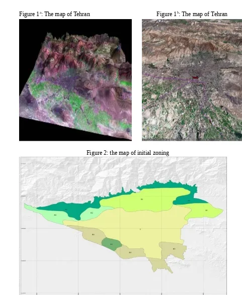
ehran was selected as a case study for this research study. Tehran, as the capital of Iran with an approximate area of 700 square kilometers and a population of 8.5 million, is the economical, cultural, and social center of Iran. Figure 1a and 1b illustrates the map of
Tehran located in the central Alborz watershed.
The contemporary urban development pattern of Tehran dates back to only after the Second World War, when a significant rural exodus transformed the cultural landscapes of provincial centers; and was particularly noticeable in the capital city. As Iran’s political, economical, cultural, and administrative capital, Tehran has undergone an exponential growth in population. Over a 30-year period (1930-1960), Tehran’s growth had initially been from downtown towards the north, with a vertical axis of development that was defined by major axes of transportation at early times. Since 1970, the second phase of Tehran’s urban growth adopted an east-to-west axis (Tehran master Plan, 2006). Due to continued migrations, the urban growth pattern around major vertical (north-south) axes was first replaced by a temporary east-to-west axis of growth, but supplanted later by a sporadic, patchy growth pattern in the suburban zones. The variegated consequences of this unattended urban growth included complex and gradual landscape transformations veering towards an almost complete loss of natural capital accompanied with incremental deterioration of public health conditions due to alterations of vital ecological processes.
METHOD
Landscape ecology studies the interaction between spatial and temporal pattern and ecological processes (Turner et al. 1998). By applying landscape ecology and urban ecology principles, we can better understand what urban landscape alterations are and how they may possibly be restored for an improved urban environment. The underlying premise of urban ecology as a sub-discipline of ecology is that the explicit composition and spatial form of an urban landscape mosaic consisting of interdependent ecosystems affect ecological processes (Burel 2003, Forman and Godron 1986). Moreover, chorological interdependencies between heterogeneous environments provide spatial solutions in addressing land use objectives including urban development planning (Forman 1995a). Urban ecology responds to the spatial dimension of urban environmental issues or landscape function on the basis of “function-structure” feedbacks between specific urban landscape structural alterations and particular urban environmental functions. But all spatially relevant issues are scale dependent in the sense that their explicit partial perception require specific scales of observation. There are no
normative scales of analysis because landscapes are essentially unique living entities (Baschak & Brown 1998), and different levels of analysis at different scales are required for a general understanding of relations between urban landscape structure and urban environmental function or for a specific comprehension of relations between remnant patch mosaic networks and air and water related environmental issues. In spite of the fact that corrective measures and restoration tasks have clear priorities in respect to time and locations within the city, an efficient restoration plan requires the adoption of an integrated approach to cope with the complex set of corrective measures regarding the remnant patch network and its context and to account for different scales with their feed backs at the same or different scales separately or simultaneously.
The present study was carried out in the following stages in order to: 1. Define the driving forces affecting the urban environmental quality, 2. Mapping landscape structure,
3. Create the initial zoning by overlaying above two maps 4. Define the social driving forces
5. Overlay the initial zoning with social driving forces for the final zoning 6. Define improving measures for each zone
FINDINGS & DISCUSSION
The locations and priority for various measures leading to the promotion of urban environmental quality could then be identified.
1. The first step was, Defining the driving forces affecting the urban environmental quality. Table 1 presents the different aspects of the improving measures (e.g. ecological status, grain size, and socioeconomic status) and the list of maps provided in each aspect.
2. Locate the structures and natural driving forces by mapping. Locating the structures and natural driving forces by mapping. It shuold be noted that for creating maps about landscape structures, Landsat satellite data (2002) using the FRAGSTAT software was used. Three categories of green, open, and constructed spaces were classified and elements in each category were evaluated in terms of their occupation area (i.e. CAP: Class Area Proportion), the distance between elements (i.e. MNND: Mean Nearest Niebuhr Distance), and the size of patches (i.e. MPS: Mean Patch Size). Land use maps of 1: 2,000 and 1:5,000 scales and base topographic maps of 1:25,000, officially released by the Central Iranian Bureau of Statistic (2000 to 2004) and the Geographical Institute of the Army (2004) were also employed.
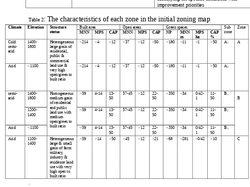
3. Create the initial zoning by overlaying the map of structures and natural driving forces. To do this, the map of structures was overlaid with climatic, water resources and Geomorphologic maps. The outputs were maps illustrating the initial zoning with 3 zones (i.e. A, B and C) and 6 sub-zones (i.e. A1, A2, B1, B2, B3 and C)
economic aspects it is impossible to comprehend the dynamics of urban systems. Social driving forces were also defined in each urban area based on the statistics made available by the National Statistical Center of Iran at the scale of urban plots for 2007 through the followings:
Demographic: population density, and changes (migration)
Social system: organization and interdependencies of economic with
social phenomenon,
Social resources: active population, educational levels, and social institutions,
Social organization: rights, governance and leisure,
Social changes: positions, acceptance of innovation and environmental awareness,
Social differentiation is the result of relative presence or absence of these attributes with their respective spatial representation.
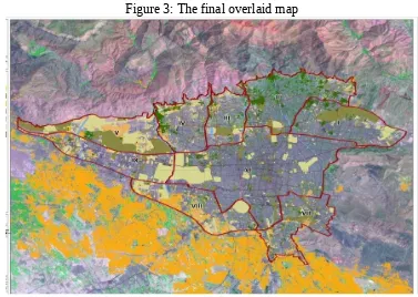
5. Spatial integration of final zoning with social features and spatial distribution of driving forces in Tehran to obtain the final bio-physical and socio-economic homogeneous zones.
6. Define improving measures for each zone at the final zoning. In this stage, it is supposed to define improving measures and the corresponding policy orientations concerning those elements which provide the city with environmental services by considering the characteristics of each zone. In each zone, the general characteristics of urban landscape matrix include open lands, farmlands, green lands and gardens. Policies and considerations for improving the environmental conditions of each zone is presented below
Table1: Subsystems and driving forces affecting and being affected by urban environmental quality
.
Aspects (subsystems)
Mapping the driving forces for integration
Geomorphology Strategic considerationsPlanning and prioritizing the improvement measures
Urban status Grain size in urban landscape
structure
homogeneity of physical structure trend of transformations
Technical consideration appropriate to the structure
Considerations concerning the executive priorities
Socioeconomic and
cultural status Population density, migration, employment and financial status, real state price and regional price differences
Identifying the conditions whether they are appropriate for perseveration,
transformation or rehabilitation
Identifying the specific conditions with improvement priorities
Table 2
: The characteristics of each zone in the initial zoning map
Figure 1a: The map of Tehran Figure 1b: The map of Tehran
Figure 2: the map of initial zoning
Figure 3: The final overlaid map
Table 3: The
characteristics of climate and structure of each zone in the final
zoning
Table 4: The characteristics of socioeconomic and cultural status of each
zone in the final zoning.
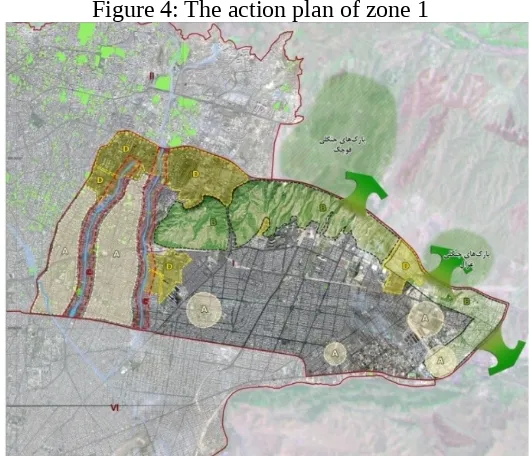
Zone 1: This zone is situated at the upstream (north and northeast) of the Tehran city with a semi-arid climate. Special structural elements (river-valleys and hills) are easily
identifiable. In this zone, with regards to the characteristics of urban matrix, open lands, farmlands, green spaces, and gardens are seen with a quantitative transformation. Open spaces have low connectivity and high fragmentation. Open space patches have a mean size of 1.1 hectares. The mean size of green space patches is 1.3 hectares with low connectivity and high fragmentation. Constructed spaces with low connectivity and high fragmentation are dominant. The action plan of this zone would be:
To maintain the present status of open and green spaces scattered
To restore continuity in the Lavizan open spaces hills to the Tehran suburb of Forest Parks (e.g. Quchak and Qazal)
Conservation, restoration and development of open spaces in the river valley margin Conversion of land to be leaving or incompatible land uses (e.g. military uses) to the open spaces for the restoration of connectivity
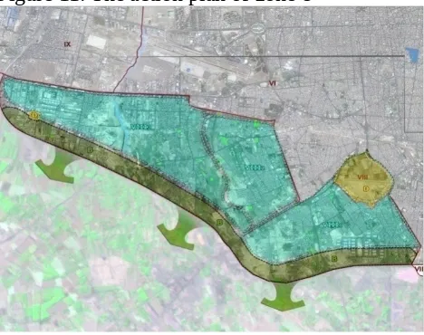
Figure 4: The action plan of zone 1
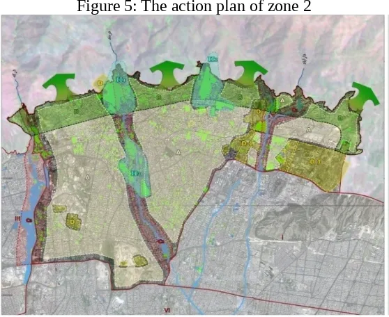
Zone 2: This zone is located at the upstream (north and northeast) of the Tehran city with a semi-arid climate. Special structural elements (river-valleys and hills) are easily identifiable in this zone.Regarding the characteristics of urban matrix, there are open lands, farmlands, green spaces, and gardens in this zone with a quantitative transformation. Open spaces in this zone are medium-grained with medium connectivity. Open space patches have a mean size of 0.8 hectares. In this zone, the green spaces where have a medium connectivity, are decreasing and, where have the mean size of 1.9 hectares, are coarse-grained. Being fine-grained, constructed spaces are dominant. The action plan of this zone is similar to zone 1. In this zone must fully protect the status of large patchesof green spaces due to their ecological value.
Figure 5: The action plan of zone 2
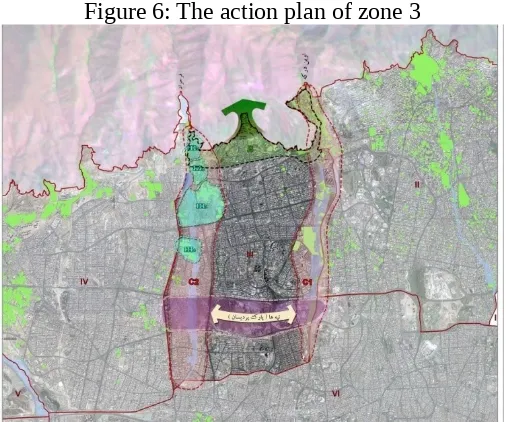
Zone 3: This zone encompasses arid and semi-arid climate, hills and rivers, and small mountainous subzones in the northern range of this zone. Regarding the characteristics of urban matrix, open spaces, farmlands, green spaces, and gardens are seen in this zone. Urban matrix transformation is qualitative and quantitative with heterogonous grain size. Open spaces in the zone are medium-grained. Regarding the patches with a mean size of 1.3 hectares, open spaces mosaic is medium-grained, compared with the other zones. The number of open space patches in this part of the city is notable. Despite of having the large area of this zone, green spaces in this zone due to a decrease in the size of patches and relatively high distances have undergone fragmentation and have medium connectivity. In this zone, constructed spaces are also fine-grained. The action plan of this zone would be fully protect the status of large patches of green spaces surrounding the FARAHZAD river valley due to their ecological value and Use of the existing open space in the PARDISAN hill and to create and restore the integrity and open green spaces
Zone 4: Regarding the environmental characteristics, this zone is situated at the upstream of the foothills with a semi-arid climate (particularly in the upper part of this zone) and an arid climate (in the middle part of this zone) which has structural elements such as river-valleys and hills. With regards to the characteristics of urban matrix, there are open spaces, farmlands, green lands, and gardens. Urban matrix has qualitative and quantitative transformations, though the patches are coarse-grained with heterogeneous mosaic. Green spaces in this zone are fine-grained with medium connectivity. The number of green space patches is notable but these spaces are medium-grained with medium connectivity. The action plan of this zone is similar to zone 3 and the others would be:Fully protect the status of large patches of green spaces and quality improvement of gardens and green spaces in this zone according to the social and economic characteristics to create compatible land uses with nature outing. To restore the continuity of the existing and large open space between two river valleys (i.e. Morad Abad and Hesarak)
Figure6: The action plan of zone 4
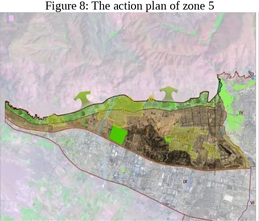
Zone 5: Regarding the environmental characteristics, this zone is situated in a medium height level (1200-1400 meters) and two categories of semi-arid and arid climate. In this zone, structural elements of the landscape are river valleys and hills. Regarding the characteristics of urban matrix, open spaces, farmlands, green spaces, and gardens are identifiable. Urban matrix has quantitative transformations. This zone is heterogeneously coarse-grained. Constructed spaces are fine-grained with low connectivity. Open spaces are coarse-grained with high connectivity and increasing fragmentation. Open spaces are also coarse-grained with medium connectivity. The action plan of this zone would be first restoring the continuity of existing open spaces to the countryside. Then, conversion of land to be leaving or incompatible land uses (e.g. military uses) to the open spaces for the restoration of continuity. Conservation, restoration and development of open spaces and prevention of the spread of house building in this zone via the policy implementation in order to restore dense development in the downtown.
Zone 6: This zone is situated at a height of 1100 to 1200 meters, in alluvial plains and fine-grained sediments with an arid climate. One of the characteristics of this zone is the lack of special structural elements of landscape. Regarding the characteristics of urban matrix, open spaces, farmlands, green spaces, and gardens are identifiable. In this zone, urban landscape matrix is fine-grained and more heterogeneous with more qualitative transformations. The mean size of patches in the constructed spaces is relatively high. Green spaces are highly fine-grained with high fragmentation and low connectivity. Open spaces in this zone are identified as being highly fine-grained with a limited number of patches, low connectivity and higher degree of fragmentation. The action plan of this zone would be maintain the present status of open and green spaces scattered and Conversion of land to be leaving or incompatible land uses (e.g. military uses) to the open spaces for the restoration of continuity.
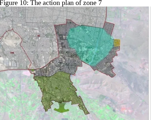
Zone 7: Regarding the environmental characteristics, this zone is situated at a height of less than 1100 to 1200 meters, in alluvial plains with an arid climate. The lack of special structural elements of landscape is one of the characteristics of this zone. Regarding the characteristics of urban matrix, open spaces, farmlands, green spaces, and gardens are identifiable. In this zone, urban landscape matrix tends towards qualitative transformations and is evaluated as fine-grained in heterogeneous mosaic. Constructed spaces, in this zone, are relatively coarse-grained and the open spaces are fine-grained with low connectivity and a high degree of fragmentation. Green spaces have medium fragmentation and connectivity. The action plan of this zone would be:
To restore the continuity of existing open spaces to the countryside (i.e. agricultural land).
Conversion of abandoned lands or incompatible land uses (e.g. military uses) to the open spaces for the restoration of continuity.
Zone 8: Regarding the environmental characteristics, this zone is situated at the downstream (south) of the Tehran city, where the height is less than 1100-1200 meters, located on old alluvial fans and alluvial plains and has an arid climate. Regarding the characteristics of urban matrix, open spaces, farmlands, green spaces, and gardens are identifiable. Urban landscape matrix has qualitative and quantitative transformations in heterogeneous land mosaicGreen spaces, in this zone, have low connectivity with a tendency to higher fragmentation. Open spaces are also fine-grained with high fragmentation and low connectivity. The action plan would be similar to zone 7:
Figure 11: The action plan of zone 8
Zone 9: Regarding the environmental characteristics, this zone is situated at a height of 1200 to 1400 meters in old and new alluvial fans with an arid climate. Regarding the characteristics of urban matrix, open spaces, farmlands, green spaces, and gardens are identifiable. Urban landscape matrix has quantitative transformations and heterogeneous grain size. In this zone, the area of constructed spaces is relatively high, though the patches are fine-grained with medium connectivity. Opens spaces are medium-grained with medium connectivity. Due to the presence of industries, the pollution is high in this zone. The action plan of this zone would be:Conversion of land to be leaving or incompatible land uses (e.g. military uses) to the open spaces for the restoration of continuity of open spaces and To restore the continuity of the existing open spaces to the suburbs southwest of the city (i.e. agricultural land).
CONCLUSION
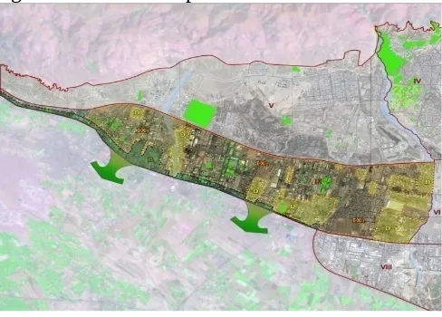
Based on the sum or accumulation of the 9 separate action plans suggested above for different homogeneous zones of Tehran urban landscape, the most significant ecological planning strategy for Teheran consists of conservation, restoration and development of open and green spaces particularly with in river valleys and over hills (transversing the capital urban landscape from the northern and the eastern high-lands of mountains to the south and the western plains respectively. This natural matrix connectivity may be complimented if not completed by restoration of connectedness between the remaining open and green spaces within the city (against urban development pressures). Then we are developing an ecological refuge network that would provide Tehran fresh air, water and life support services (figure 13).
Using this new approach (i.e. Ecology of cities) in urban ecology studies, urban landscape is considered as a living system and all economic-cultural resources are taken into account in these studies. In a metropolitan city like Tehran (with a high demand for construction and the extremely high price of land to be purchased for reclamations), preserving the little environmental services (particularly regulation and provision) that is provided by the little natural elements (e.g. river-valleys) still remaining is the only significant practical effort in this respect. In promoting the quality of urban environment in Tehran, limitations such as the arid climate and lack of permanent rivers must be carefully taken into account. In this research paper, efforts were focused on the identification of appropriate measures that are practical to be undertaken in each zone based on their natural, urban and social characteristics.
It seems that the two main priority strategic aims for environmental quality improvement and ecological integrity or sustainable development of Tehran consist of improvement and/or restoration of natural matrix connectivity in the urban landscape through restoration or rehabilitation of natural refuge network (green patches and water flow) made available by river-valley corridors extending from mountains into the city. In addition, to focusing on utilization of the full advantages provided by the existing river-valley system from north to south and the limited open spaces on the hills for connecting the scattered green and open space patches before these valuable ecological infrastructures are also altered, adoption of alternative complementary goals such as connecting coarse-grained to fine-grained green and open patches can increase the function and stability of the above mention refuge network. Rehabilitation of Tehran’s urban life support system through natural matrix connectivity may begin from the north-western edge or urban fringe and all other complementary efforts should be based on measures that are practical to be undertaken in each zone based on their natural, urban and social characteristics found by this integrated research. In fact in all respects the north western parts of the capital merit priority for more cost effective preventive measures. Regarding restorations (of green and open patch mosaic) in the central downtown too the best seems to begin investments from northern mountains and the southern fringe gradually extending towards the central Tehran otherwise any independent project within the centre of the city will be too expensive and not cost-effective or even potentially irrelevant with no potential for later up-scaling.
REFERENCES
Ahern jack.2011. from fail-safe to safe_ to_ fail : ustainability and resilience in the new urban world . Landscape and urban planning 100(2011)341-343
Alberti, M; 2005.The Effects of Urban pattern on ecosystem function. Integration Regional Science Review.28(2):168-19
Andersson Erik,2006. Urban Landscapes and Sustainable Cities. Ecology and Society 11(1):34
Baschak, L & Brown, R.; 1998, River systems and Landscape networks,in: Mosaic landscape and ecological processes, edited by Hansson L.et al. Chaman & Hall, London, U.K.
Burel F.; 2003, Landscape Ecology: Concepts, Methods and Applications, Science Publishers, Inc. USA
Centre Statistics of Iran, survey results at plot level, 2007
DOE - Department Of Environment; 2001, Urban environment report of the capital, Tehran, Iran
Forman R T.T., Godron M.; 1986, Landscape Ecology, John Wiley & Sons, New York, N.Y, USA.
Forman R.TT.; 1995 (a), Some general principles of landscape and regional ecology, Landscape Ecology, vol. 10 no. 3 pp. 133-142 (1995) SPB Academic Publishing by Amsterdam
Forman R.TT.; 1995 (b), Land Mosaics, The ecology of landscape and regions”
second edition, Cambridge University Press, USA
Ingegnoli, Vittorio. 2002. Landscape Ecology :A widening Foundation. Springer:N.Y
Naveh, Z. & Liberman, A.S.; 1984, Landscape ecology, Springer-Verlag, New York, N.Y. U.S.A.
Pickett.S.T.A, Cadenasso.M.L, Grove J.M,2004. Resilient Cities: Meaning,Model and Metaphor for Integrating the Ecological, Socio-Economic and Planning Realms in .Landscape & Urban Planning:69(369-384)
Tehran master Plan Reports, 2006
Turner M.G. ; 1998, Landscape ecology; The effect of pattern on process, in Annual Review Ecological Systems, 20, 171-197
Wiens John A. 1995 Landscape mosaic and ecological theory, Mosaic landscape
and ecological processes, Chapman & Hall London
Yavari ,A .Sotoudeh ,A.Parivar, P. (2007): Urban Environmental Quality & Landscape Structural Restoration In arid mountain environment; Tehran – Iran, International Journal of Environmental Research vol 4 (325-340)
Zonneveld, I.S., 1995. Land ecology: an introduction to landscape ecology as a basefor land evaluation, and management and conservation. SPB Academic Publishing, Amsterdam