AN INTERACTIVE IMMERSIVE SERIOUS GAME APPLICATION FOR
KUNYU QUANTU WORLD MAP
Shih-Ting Peng1, Shih-Yu Hsu2, Chun-Ko Hsieh1
1
National Palace Museum, [email protected], [email protected] 2
New York University, [email protected]
KEY WORDS: Museum, Education, Serious Game, map, interactive, immersive, Kunyu Quantu World Map
ABSTRACT:
In recent years, more and more digital technologies and innovative concepts are applied on museum education. One of the concepts applied is “Serious game.” Serious game is not designed for entertainment purpose but allows users to learn real world’s cultural and educational knowledge in the virtual world through game-experiencing. Technologies applied on serious game are identical to those applied on entertainment game. Nowadays, the interactive technology applications considering users’ movement and gestures in physical spaces are developing rapidly, which are extensively used in entertainment games, such as Kinect-based games. The ability to explore space via Kinect-based games can be incorporated into the design of serious game. The ancient world map, Kunyu Quantu, from the collection of the National Palace Museum is therefore applied in serious game development. In general, the ancient world map does not only provide geological information, but also contains museum knowledge. This particular ancient world map is an excellent content applied in games as teaching material. In the 17th century, it was first used by a missionary as a medium to teach the Kangxi Emperor of the latest geologic and scientific spirits from the West. On this map, it also includes written biological knowledge and climate knowledge. Therefore, this research aims to present the design of the interactive and immersive serious game based installation that developed from the rich content of the Kunyu Quantu World Map, and to analyse visitor’s experience in terms of real world’s cultural knowledge learning and interactive responses.
1. INTRODUCTION
Recently, more museums are adopting digital technology applications on museum displays and educational purposes, the National Palace Museum included. The National Palace Museum has been practicing the innovative idea of future museum, which is incorporating digital technologies, and has developed a variety of digital museum applications.
2013), Mao-Kung Ting Interactive Installation (Hsieh et al, 2014), and more were developed. These installations have had travelled to Los Angeles, Taipei, Tainan, Taichung, and Chunghwa through touring exhibitions. In order to engage audience, the research team selects China’s first world map from the collection of the National Palace Museum as its principal game content. The serious game integrates immersive, Kinect-based, and other technologies. The design of this interactive immersive serious game application is based on Kunyu Quantu accordingly. Serious game combines real-world knowledge into video games or online games for educational training or game learning purpose. Up to date, countless interactive technologies were applied to various popular digital games.
The National Palace Museum is a leading museum in Chinese cultural heritage section. The digital content of this application is from one of the most important collection of the National Palace Museum, Kunyu Quantu World Map (National Palace Museum, 2015). Kunyu Quantu was completed in 1674 and was presented to the Kangxi Emperor by a Belgian Jesuit missionary, named Ferdinand Verbiest. The world map brought in the latest geographical concepts to China. For example, it was not until 17th century did China believed the world is round and gets rid of old belief a flat earth. Therefore, Kunyu Quantu was Ferdinand Verbiest’s
best tool to explain the Western knowledge to the Kangxi Emperor during the 17th century. Also, Kunyu Quantu has documented various categorized information, such as ocean currents, winds and other geological information. In addition, it has more than 30 drawings of legendary creatures and animals unseen in Asia with written explanations on the map.
The scope of this research is proposing an immersive interactive installation that integrates museum knowledge and multi-modal sensing approaches. The idea is to incubate from game-based designs to build up an antique map multimedia application. And share the results in the end. This application is exhibited in “Children’s NPM Digital Playground” special exhibition in Taipei City from November 27th, 2014 to March 15th, 2015. Data are collected by focus group interviews during the exhibition period. The research questions are as following: (a) Does this application help children appreciate the atlas? (b) Does this application inspire children’s interest? (c) How satisfactory is this application? (d) Does this application provide a museum experience? We provide related works in section 2. Details of the implementation, system architecture and interactive scenarios are described in section 3. Then the descriptions of the evaluation are described in section 4. Finally, this paper ends with results and discussions in section 5.
2. RELATED WORKS
■2.1 Serious Game
Serious game is a concept that has been proposed for years. Mike Zyda (2005) defined serious game as “a mental contest, played with a computer in accordance with specific rules, that uses entertainment to further government or corporate training, education, health, public policy, and strategic communication objectives”. Therefore, various applications have been developed. For example, a health serious game teaches the skills involved in training future intervention radiologists (Chan, 2012), and a military relevant simulation framework for adapting scenarios in a game engine based upon the user’s neurocognitive and psychophysiological state is also proposed (Parsons and James, 2012). The use of games to support cultural heritage purposes is well documented in Anderson, Liarokapis and Peters’s investigation, including three types of computer-game-like applications: prototypes and demonstrators; virtual museums; and commercial historical games (Anderson et al, 2010). Chen (2010) implemented Jing-Hang Grand Canal Serious Heritage Game. This work conducts a comparative study to examine the important design factors that impact on user immersion in serious heritage games.
■
2.2 Interactive and Immersive Multimedia Application for Ancient AtlasThe concept of integrating human being’s perception with real environment via multimedia devices has had been long practiced. Milgram and
Kishino (1994) examine the “virtual space” and “reality” in the same visual display environments. Bowman (1998) mentions Virtual Reality allows users to experience space naturally. Hernandez (2003) describes 3 ways to make immersion. There are: Headmounted display, Cubicles with Wall projection, and Panoramic Projection System. He uses HMD way to develop an immersive, walkable and wireless, called Empty museum application. Song (2003) applies Virtual Reality to build a Virtual tour system of Singaporean Heritage. This system uses a Chinese calligraphy brush as its inactive interface. Stawniak and Walczak (2006) present the GeoARCO system. The virtual exhibition system presents the content of European Augmented Representation of Cultural Objects project in a geographical context. Kortbek and Grønbæk (2008) apply three spatial multimedia techniques to the Mariko Mori exhibition. Kenderdine (2010) describe a serious of immersive architecture and their related visual, sonic techniques for cultural heritage landscape. He highlights the strategies of applying the embodied,
About researches on map, a location-based service is developed by geo-multimedia information system that provides user’s actual location by collecting geologic information from GPS or mobile devices (Fritsch, 2001). Alexander Almer and Harald Stelzl (2002) develop a geo-multimedia tourism application. The system presents geo-multimedia information in different media device. Giang Tran Thi Huong and Duy Nguyen Ba (2012) purpose an interactive multimedia atlas system for Vietnam’s tourists. Besides physical space of geologic information system, some multimedia works are for ancient atlas. Pilar Chias and Tomas Abad (2008) designed and implemented a relational database of the ancient maps. While the user querying the database, it will response features and visual results together. Gustavo Marfia, Marco Roccetti, Marco Zanichelli and Angelo Varni (2012) integrated the HCI and mixed reality technology to design an application that supports the exploration of Mercator’s World Atlas. This is a book of atlas and the first time applying a series of ancient atlas to describe the world. The system hopes to provide simple and intuitive way to engage audience’s experience to travel through Mercator’s volume. They designed an interaction experience of Mercator Atlas Robot application for this specific atlas book. However, the Mercator’s world atlas is an atlas book, whereas Kunyu Quantu world map is a plane development based on x and y axes. In terms of physical forms, Mercator’s world atlas and Kunyu Quantu are different. Thus, different types of world map resulting different ways of interaction. In this research, we focus on Kunyu Quantu, the plane development world map as main research target.
3. IMPLEMENTATION
This session explains how Kunyu Quantu interactive installation is put together. Implementations of system architecture and interactive scenarios are introduced in the following paragraphs. The interactive device is composed of projectors, sensors, and servers.
■3.1 System Architecture
The installation used 96000-lms projectors to create an immersive panoramic environment. One projector is used on south-wall scene, two on north-wall scene, two on east north-wall and west north-wall each. The floor scene uses 4 projectors and image-blending software to establish an 8-meter long and 6-meter wide display scene (figure 1). The size of floor scene is large enough for children to run and to explore the knowledge in the map. The movement-detecting sensor is Kinect, which is commonly used in present kinetic art or interactive installations. 6 Kinects around the wall and 4 on the ceiling are used to detect the movements and gestures of visitors. For the interactive installation, three computers are used as system server. These computers that are connected by hub allows main computer communicate with slave computers. Moreover, to increase the variety of the interactive sense, 6 fans are integrated into the installation which will create wind during specific time. There are also microphones which detect volume of
visitors so that visitors can interact by voice (figure 2).
Figure 1. Floor plan of Kunyu Quantu World Map installation.
Figure 2. An image of projectors, kinects and fans are installed on the ceiling.
■
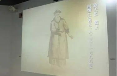
3.2 Interactive Scenarios 3.2.1 Scenario 1: IntroductionA panoramic theatrical animation is projected onto 4 walls and the floor as well. Telling the story of how men were exploring the universe and find out more about the world we are living in. Through the animation, participants learn the story of how Ferdinand Verbiest first came to China and introduced Kunyu Quantu the world map to the Emperor Kangxi (figure 3). This part allows participants to witness the history happening in the virtual time and space.
3.2.2 Scenario 2: Explore the world
The concept of geographic coordinate system is introduced in scenario 2. Narrator is the animated Ferdinand Verbiest. He explains prime meridian (longitude) cut the earth into two hemispheres, which defines west and east. Equator (latitude) intersects the earth into north and south hemispheres (figure 4). He also points out the existence of five continents.
Figure 4. Animation of geographic coordinate system is vividly presented in front of participants. Explaining how prime meridian and equator divide and intersect the earth.
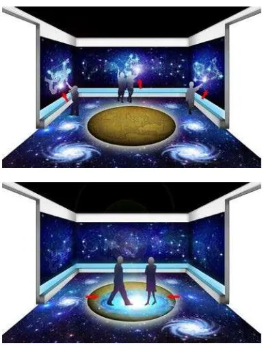
3.2.3 Scenario 3: Astrology
Scenario 3 is the interactive game that integrates astrology as game content. In ancient times, Babylonians explore the vast sky by defining 12 zodiac signs from the constellation. During this interactive stage, 12 zodiac signs are glistening on the surrounding walls. As showed in figure 5 & 6, participants can walk up to the glistening stars on the wall and wave to it. After the arm movement is detected, full images of the zodiac signs would slowly appeared on the walls. At the same time, 4-6 nebulas, the glowing interstellar clouds, are showing on the floor. These nebulas would trace the participants’ footsteps. When two participants run into each other, their nebulas would clash into each other and create an explosion of a massive star cloud (see figure 7).
Figure 5. Participants interact in scenario 3: call out the 12 zodiac signs by waving arms.
Figure 6. The adult participant is revealing the modern image of the ancient animal by waving her arm while her kid is capturing the exotic animals on the floor with glowing ring at her foot.
Figure 7. Simulated images demonstrate how participants walking on nebulas. When two participants run into each other a massive explosion of star cloud is created.
4. EVALUATION
■ 4.1 Participants
5 participants were interviewed in this user experience research. This interview group are the volunteers at the “Children’s NPM Digital Playground” special exhibition. They volunteer to give interactive instructions of Kunyu Quantu World Map installation. They are the first person to receive and observe user’s responses. Therefore, volunteered-instructors of this installation are chosen as the research target.
4 female volunteers and 1 male volunteer are interviewed. 4 out of 5 volunteers are aged above 50 years old. One volunteer is aged between 40-49 years old. 4 persons hold high school degree while the other person holds junior high degree only. They are all residents in Taipei City.
■ 4.2 Procedures
The interview was conducted during the “Children’s NPM Digital Playground” special exhibition in Taipei. This research method adopted focus group interview to collect users and participants’ opinion. 5 volunteers are invited to participate in this conversational interview. Open-ended questions are designed to collect volunteer’s first-hand information and feedbacks from both volunteers and users. The group interview is voice recorded and the interview is proceeded in Chinese. The results and discussions are later translated into English in section 5.
Open-ended questions representing different aspects respectively are shown as below:
Aspects A, Interpretations:
·
How do the participants think of the design of this interactive installations relating to the historical map?·
What do the participants think of this approach for a museum to introduce the artifact to children by designing an interactive game installation?·
In order to increase children’s interest in the artifact, how did the users respond to this interactive game installation?·
What are the differences between an interactive game installation experience and a museum visiting experience?Aspects B, Education:
·
How much do the participants understand the characteristics of the historical map after experienced the interactive game installation?·
What are the different responses participants give according to the historical map before and after experience the interactive game installation?·
What could be done to increase children’s interest in visiting the National Palace Museum?Aspects C, Satisfactory:
·
How do the participants think of this interactive installation?Aspects D, Future development:
·
In terms of modern technology, what is the most important thing to a museum in the twenty-first century?·
What should a museum try to approach and focus more in the future?·
What is the flaw or restriction of this installation?·
What needs improvement?5. RESULTS AND DISCUSSIONS
■5.1 Learning
Based on volunteers’ feedbacks and their close observations with visitors, Kunyu Quantu World Map immersive interactive installation is tremendously helpful in terms of learning experience. This device provides educational visual aids to its users. With its informative narrations, users’ memories are enhanced through game playing and could be linked to their past learning experience. Participant A gives an example of how a group of school pupils make use of the device to learn.
Participant A: I was surprised that there was one group of kindergarten students came with their teacher. They’ve just learned about the 12 zodiac signs and the 7 continents at school. Their teacher told me the Kunyu Quantu World Map immersive installation is an amazing teaching material for her students. It allows her students to play and learn at the same time, and review as well! This device definitely has strong educational purposes.
■5.2 Museum Experience
Equipped with modern technologies, the National Palace Museum has successfully changed it’s traditional image into a young and dynamic face. This kind of device actively approaches its visitors outside the museum. Interactive installation combining museum contents, does not only make museum resources more available to the public, but also generates potential visitor’s interest to visit to the museum. Serious game input with museum content with Chinese historical background, serves as a great incentive for visitors to learn more about Kunyu Quantu World Map. Participant B describes how immersive interactive installation enlightens him and gives him a whole new museum experience.
helps me to learn the Kunyu Quantu World Map easily. And to understand the cultural exchange activities between the East and the West during the Qing Dynasty. Most of the collection at the National Palace Museum are profound and difficult to understand. This type of interactive installation explains profound knowledge in simple language. So even children can learn quickly and absorb the knowledge. After seeing this exhibition, I have accumulated basic knowledge about the National Palace Museum. Therefore, I would like to visit the National Palace Museum and see more.
■5.3 Satisfactory
Overall, the interviewees are contented with the design of this interactive device. They are satisfied with knowledge we applied as game content. However, the biggest dissatisfaction of this device is the high dysfunctional rate. Projectors are not always working properly from time to time, which often failed to create a complete immersive environment for users to experience. Hardware of this device requires a stronger and more stable technical maintenance. Technical problems remain to be solved. Following are feedbacks from volunteers:
Participant C: Everything is okay except the dysfunctional rate. It happens quite often. We don’t know how to fix it and we have to wait until someone came to fix the problem. Software (game content) is great, very good! But the hardware (equipment) is horrible. This should be improved as first priority.
Participant D: (points out the problem in scenario 3) I really like to play this interactive device. However, the detection of body movement is in low precision. Sometimes it took ages for us to wave out the 12 zodiac signs. Or sometimes, it didn’t even show at all. The sensor equipment needs to be upgraded.
Participant E: In addition, the introduction (scenario 1) is way too long. There are many pre-school children came to play this interactive installation. However, kids don’t have patience. And scenario 1 doesn’t have any interactive engagement involved. So visitors, especially kids, are losing their interests in this device. They simply walk away... Kids just want to play games. So, make the introduction the shorter, the better.
■5.4 Future Prospects
When participants were asked about questions from Aspect D, their answers are quite similar: “This
installation still needs improvements, especially the hardware part.” They all agree that serious game
applications are the future trend in museum sector:
“This is definitely the future trend in museums!” “This interactive installation is great and helps visitors to learn while playing games!” “It is an educational entertainment!” Apparently, Kunyu
Quantu World Map immersive interactive installation could be further improved by lowering its dysfunctional rate and enhancing its body movement detection. This device opens up a new opportunity for visitors outside the museum. Location of museum education is no longer an obstacle. It is now movable. During traveling exhibition, anyone can learn and experience the serious game installation without barriers. Each scenario teaches users different knowledge, which is smartly integrated in fun dynamic games. Serious game design shortens the distance between museum and visitors. Through interactions in the virtual world, visitors feel closer with museum and historical artifacts. This type of media now plays an important role in museum sector. Serious game design does not only help museums to approach young generations, but also invites potential visitors to learn more about what they have just experienced. Serious game installation at the National Palace Museum has great influences on both children and adults in terms of learning experience.
■5.5 Limitations
Limitations in this research are as following: (a) This installation is only for plane development map. Atlas book format is excluded. (b) This installation is designated for big interactive movements. (c) This installation is designed for multiple users, not for single user. (d) Handicapped users can only conduct few interactive games. (e) This installation uses infrared sensor for interactive detection, therefore, the installation location has to avoid outdoor and strong lights.
ACKNOWLEDGEMENTS
This work was supported in part by the the Bright Ideas Design Co. and the Yellow Box Co. Our special thanks are due to the curators of the National Palace Museum for their great support to this project.
REFERENCES
Almer, A., & Stelzl, H. (2002). Multimedia visualisation of geo-information for tourism regions based on remote sensing data. International Archives of Photogrammetry Remote Sensing and Spatial Information Sciences, 34(4), 436-441.
Anderson, E. F., McLoughlin, L., Liarokapis, F., Peters, C., Petridis, P., & de Freitas, S. (2010). Developing serious games for cultural heritage: a state-of-the-art review. Virtual reality, 14(4), 255-275.
Chan, W. Y., Qin, J., Chui, Y. P., & Heng, P. A. (2012). A serious game for learning ultrasound-guided needle placement skills. Information Technology in Biomedicine, IEEE Transactions on, 16(6), 1032-1042.
Chen, W., Zhang, M., Pan, Z., Liu, G., Shen, H., Chen, S., & Liu, Y. (2010). Animations, games, and virtual reality for the Jing-Hang grand canal. Computer Graphics and Applications, IEEE, 30(3), 84-88.
Chias, P., & Abad, T. (2008, July). Visualising Ancient Maps as Cultural Heritage: A Relational Database of the Spanish Ancient Cartography. In Information Visualisation, 2008. IV'08. 12th International Conference (pp. 453-457). IEEE.
Fritsch, D., Klinec, D., & Volz, S. (2001). NEXUS—positioning and data management concepts for location-aware applications. Computers, environment and urban systems, 25(3), 279-291.
Froschauer, J., Merkl, D., Arends, M., & Goldfarb, D. (2013). Art history concepts at play with ThIATRO. Journal on Computing and Cultural Heritage (JOCCH), 6(2), 7.
Hernández, L., Taibo, J., Seoane, A., López, R., & López, R. (2003, December). The Empty Museum. Multi-user interaction in an immersive and physically walkable VR space. In Cyberworlds, 2003. Proceedings. 2003 International Conference on (pp. 446-452). IEEE.
Hsieh, C. K., Hung, Y. P., & Chiang, Y. C. (2011). Way to inspire the museum audiences to learn: development of the interpretative interactive installations for Chinese cultural heritage. In Edutainment Technologies. Educational Games and Virtual Reality/Augmented Reality Applications (pp. 284-291). Springer Berlin Heidelberg.
Hsieh, C. K., Hung, Y. P., Ben-Ezra, M., & Hsieh, H. F. (2013). Viewing Chinese Art on an Interactive Tabletop. Computer Graphics and Applications, IEEE, 33(3), 16-21.
Hsieh, C. K., Liao, W. C., Yu, M. C., & Hung, Y. P. (2014). Interacting with the past: Creating a time perception journey experience using kinect-based breath detection and deterioration and recovery simulation technologies. Journal on Computing and Cultural Heritage (JOCCH), 7(1), 1.
Huong, G. T. T., & Ba, D. N. (2012). The Potential of Multimedia Electronic Atlas in Promotion of Vietnam’s Tourim Industry. International Proceedings of Chemical, Biological and Environmental Engineering (IPCBEE), 30, 20-24.
Ioannides, M., Arnold, D., Niccolucci, F., & Mania, K. Geographical Presentation of Virtual Museum Exhibitions.
Kenderdine, S., Shaw, J., & Kocsis, A. (2009, October). Dramaturgies of PLACE: evaluation, embodiment and performance in PLACE-Hampi. In Proceedings of the International Conference on Advances in Computer Enterntainment Technology (pp. 249-256). ACM.
Kortbek, K. J., & Grønbæk, K. (2008, October). Interactive spatial multimedia for communication of art in the physical museum space. In Proceedings of the 16th ACM international conference on Multimedia (pp. 609-618). ACM.
Marfia, G., Roccetti, M., Zanichelli, M., & Varni, A. (2012, July). Mercator atlas robot: Bridging the gap between ancient maps and modern travelers with gestural mixed reality. In Computer Communications and Networks (ICCCN), 2012 21st International Conference on (pp. 1-5). IEEE.
Milgram, P., & Kishino, F. (1994). A taxonomy of mixed reality visual displays. IEICE TRANSACTIONS on Information and Systems, 77(12), 1321-1329.
National Palace Museum (2014).
http://www.npm.gov.tw/exh100/kangxi/en/en_work 09.html
Parsons, T. D., & Reinebold, J. L. (2012). Adaptive virtual environments for neuropsychological assessment in serious games. Consumer Electronics, IEEE Transactions on, 58(2), 197-204.
Smith, S., Cutchin, S., Rockwood, A., Saad, A., Smith, N. G., & Levy, T. E. (2012, September). Demo paper: virtual and immersive experience presentation of cultural heritage sites. In Virtual Systems and Multimedia (VSMM), 2012 18th International Conference on (pp. 645-648). IEEE.
Song, M., Elias, T., Muller-Wittig, W., & Chan, T. K. (2003, July). Using virtual reality to bring Singaporean heritage to life. In Computer Graphics International, 2003. Proceedings (pp. 240-243). IEEE.
Stawniak, M., & Walczak, K. (2006, October). Geographical presentation of virtual museum exhibitions. In Proceedings of the 7th International conference on Virtual Reality, Archaeology and Intelligent Cultural Heritage (pp. 101-108). Eurographics Association.