Page 1 of 3
Dedi Kusnadi Kalsim, October 2008 E
ENNVVIIRROONNMMEENNTT–– S
Sttaabbiilliittyy E
ECCOONNOOMMYY–– D
Deevveellooppmmeenntt
S
SOOCCIIAALL--CCUULLTTUURREE–– E
Eqquuiittaabbiilliittyy
The Model for Sustainable Peatland Development in I ndonesia
By: Dedi Kusnadi Kalsim1
1. Sustainable development Abstract
Peatland development in I ndonesia has been started since 1960. There is a fact that flood always occur in wet season meanwhile dryness and forest fire always occur in dry season. I t is indicating that there is an unbalance due to change of peatland function from conservation to agricultural land. This paper proposes the model for sustainable peatland development. The method for delineating of conservation area and agriculture area is proposed in this paper.
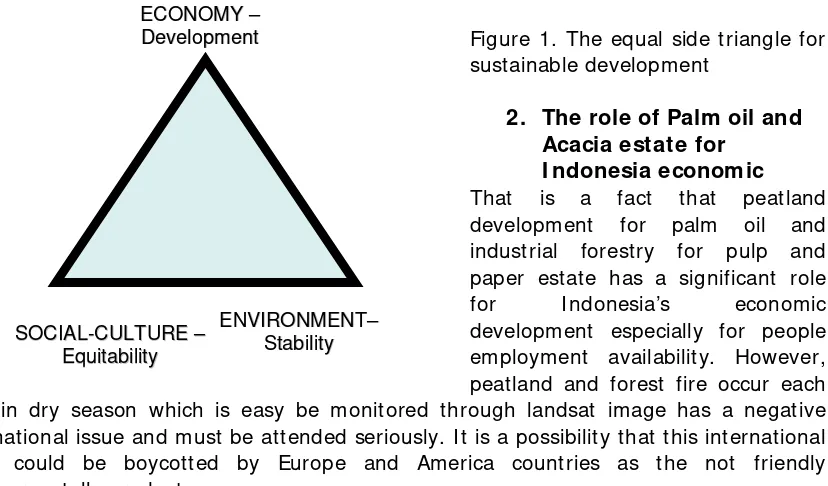
I n I ndonesia as developing country it is known the concept of sustainable development which is principally shown in Figure 1. There is an equal side triangle of Development – Environment – Social and Culture, which should be developed in balance, in other to get the sustainable development.
Figure 1. The equal side triangle for sustainable development
2. The role of Palm oil and Acacia estate for
I ndonesia economic
That is a fact that peatland development for palm oil and industrial forestry for pulp and paper estate has a significant role for I ndonesia’s economic development especially for people employment availability. However, peatland and forest fire occur each year in dry season which is easy be monitored through landsat image has a negative international issue and must be attended seriously. I t is a possibility that this international issue could be boycotted by Europe and America countries as the not friendly environmentally products.
2. The conservation peatland area
Up to now the definition of peatland conservation area refers to Keppres no 32 1990 2
1Ir, M.Eng., Dip.HE, Head Lector of Soil and Water Engineering Laboratory. Bogor Agricultural University. Email:
concerning the protected area management. The protected area consists of (a) forest protected area, (b) peatland area, and (c) recharge area.
Development 2
Page 2 of 3
Dedi Kusnadi Kalsim, October 2008
/ 1 / ... FD n FF DS
deficit
Water ≤ − × × × ×
×
+X ) (E E ) L
(X1 2 1 2
The protected peatland area criterion is the peatland with peat depth more than 3 meter lied on upstream or swampy area. However, in fact a lot of peatland which more than 3 meter peat depth has been reclaimed successfully for estate (coconut, pineapple, palm oil, and acacia).
Considering the spirits of Keppres 32/ 1990 there are two things related to the sustainable development concept (Fig 1). Firstly, the conservation function to protect the surrounding or below area to manage water system protecting flood in wet season and fire due to dryness in dry season. Secondly, the peat depth more than 3 meter, perhaps at this time already known that is unsuitable for food crops, but we do not have experience for perennial and forestry crops.
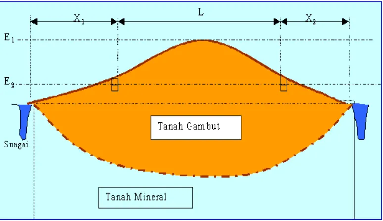
Considering the conservation function of peatland area, there are two things should be considered. Firstly, the high elevation as conservation area. Secondly, the lower part as agriculture development area. The high elevation part it is known as peat dome area. How to delineate those areas?
Using the water balance approached between the water surplus at wet season in protected area and water deficit at dry season in agriculture development area, shown in Fig 2 schematically.
Figure 2. Peat dome schematization
Note:
L: the width of protected at peat dome area; X1 and X2: the width of peatland can be developed; E1: peak peat dome elevation; E2: the highest water level in drainage canal
The quantity of water hold at conservation area in wet season should be equal or greater than the quantity of water deficit in dry season at development area (Equation 1).
Page 3 of 3
Dedi Kusnadi Kalsim, October 2008
/
Water deficit at DS can be calculated as cumulative monthly deficit, where monthly rainfall (for a certain exceedance probability) less than Crop Potential Evapotranspiration (ETc). The value of total porosity representing maximum water holding. Depletion factor representing total water drained by gravity. The actual water can be hold by peat soil is (1 - FD) x total porosity. The value of n and FD depend on the mature of peat soil. Using the average value of n and FD expressed with Equation 2.
Equation / 3/ showing it is used sign of = if the water management is quite good, the sign of < if water management is not good. Those equation can be used for calculating the proportion of L with (X1 + X2), depend on local specific condition.
3. The w ater management
The water management is the key role to insure the sustainable peatland
development. A good water management system should be able to manage the canal water level for several purposes. I t is called as the controlled drainage system. Principally the water level should be designed as high as possible, but as low as required. I t is mean that if Acacia growth well at 0.5~ 0.8 meter of ground water depth (depend on the growth stage), it is not necessary to make lower than 0.8 meter. Field experience showed that groundwater depth management at field not more than 1 meter in dry season is a good practice to prevent and manage peatland fire hazzard. Climate data at Riau Province, showed that cumulative water deficit at dry year could make a cumulative lowering groundwater level 0.4 meter. Therefore at the starting dry season the groundwater level should be set on 0.6 meter depth maximum.
Lay out of the main canal should be traced parallel with the contour line equipped with side channel spillway which flowing excess water to collector canal crossed contour line. The collector canal should be provided with water level controlled structure (overflow type). The difference of water elevation at upstream and downstream is about 0.5 m. Management of groundwater level as high as possible but as low as required by the crop, has an advantage to minimize the land subsidence.
4. Final remarks