Land Suitability Analysis of Biodiesel Crop Kemiri Sunan
(Reutealis trisperma (Blanco) Airy Shaw) in The Province of West
Java, Indonesia
Wening Sri Wulandari1*, Dudung Darusman 2, Cecep Kusmana2, Widiatmaka 3
1. Doctoral Student of Natural Resources and Environment Management Programme, Bogor Agriculture University, Bogor, Indonesia
2. Department of Forestry, Bogor Agriculture University, Bogor, Indonesia 3. Department of Agriculture, Bogor Agriculture University, Bogor, Indonesia
*E-mail for the corresponding author: [email protected]
Abstract
Increase in fossil energy demand should be balanced with the development of renewable energy, one of the source is from vegetable materials that could be processed into biodiesel. One of prospective biodiesel crop in Indonesia is Kemiri Sunan (Reutealis trisperma (Blanco) Airy Shaw). Kemiri sunan has certain growth condition for optimum reproduction. Land suitability analysis is needed to determine potential available land for planting kemiri sunan on West Java Province. To determine land suitability Multi Criteria Evaluation (MCE) is used, based on Geographic Information System (GIS). Determination of factors numerical weight was done using Analytical Hierarchy Process (AHP) method. The analytical parameter consist of climate criteria (altitude, rainfall, the number of dry month, humidity, and temperature) and land criteria (slope, soil texture, pH, solum thickness, and drainage). Result shows the area of suitable land for planting kemiri sunan is 981,067.20 Ha consist of 86,855.70 Ha of land in suitable criteria, 799,947.58 Ha land in moderately suitable category, dan 94,263.92 Ha of land in marginally suitable category. The suitable land area for planting kemiri sunan is spread in 23 districts on West Java Province. While available potential land for planting kemiri sunan after deduction by area allocated for another use is 141,955.56 Ha which consist of 19,582.74 Ha of land in suitable category, 103,974.62 Ha land in moderately suitable category, and 18,398.20 Ha of land in marginally suitable category. Area of available land is spread in 17 districts on West Java Province. Kemiri sunan is recommended for development at West Java Province as an effort for providing alternative energy and environment rehabilitation.
Keywords: Land suitability, Land aviability, Kemiri sunan (Reutealis trisperma (Blanco) Airy Shaw), Biodiesel
1. Introduction
Nations in the world are aware of the increased use of fossil energy which is not balance with the availability of sustainable energy. Kusumaningrum and Munawar (2013) stated that beside used for domestic consumption, Indonesia fossil energy has been continually exported. Energy shortage will happen without proper management. The government of The Republic of Indonesia has taken steps connected to the depletion of fossil based energy through the establishment of The 2025 Sustainable Energy Vision. It is targeted for the next 15 years to come the minimal utilization of sustainable energy is 25% of total energy consumption. Indonesia possesses renewable energy in form of geothermal, biofuel, and other renewable energy in form of biomass, nuclear energy, hydropower, thermal energy and wind.
One of potential biofuel is biodiesel for its ability to substitute diesel fuel. Biodiesel industry has been developed in certain countries. According to Salim (2009), the increase in the Asia Pacific production capacity is an indicator of the growth in biodiesel industry and is potential to be the main source for export income as well as being part of the government strategy and policy to support environment sustainability. Furthermore Salim (2009) stated based on FAO projection in 2008, the world’s biodiesel production up to year 2017 will be dominated by the European Union countries. For that reason, Indonesia biodiesel industry needs to be supported for well development. Domac et al., (2005) stated that in developing countries, bioenergy and other renewable energy need to be promoted for its potential contribution to energy security and the benefit its provide for environment. Bioenergy development need to put into account factors affecting its implementation. According to Roos et al., (1999), critical factors to consider in the bioenergy implementation are 1). integration to other economical activities, 2). scale effect of the bioenergy market, 3). competition in bioenergy market, 4). competition to other business, 5). national policy and its influence, 6) local wisdom and local view.
One of prospective biodiesel crop in Indonesia is kemiri sunan (Reutealis trisperma (Blanco) Airy Shaw). Biodiesel originated from kemiri sunan has advantages over the other crop. The advantages are a) oil content with approximate yield of 50% (Vossen & Umali, 2002), b) Biodiesel production is quite high, c) it will not compete with food due to its 50% α-eleostearat acid content (Vossen & Umali, 2002), c) ability to
availability of feedstock wide-scale crop development is needed. The main variable is the availability of suitable land that fit the growing requirements of the crop. Thus it is necessary to acquire information of potential land area for kemiri sunan planting taking into consideration the land use and spatial pattern planning.
2. Research Objective
The objectives of this research are :
1) To review land suitability class including area and spread for planting kemiri sunan at West Java Province. 2) To review area and spread of available land for planting kemiri sunan at West Java Province.
3.Research Methods
3.1 Research location and timeframe
The study area for this research is in West Java Province, Indonesia. The selection for the study area is based on the presence of kemiri sunan crop in West Java that grow well naturally or by planting. High consumption of diesel fuel in West Java is another fact that provide opportunities for the development of biodiesel as an alternative to meet the needs for diesel fuel West Java Province is one of the provinces in Indonesia that geographically located in latitude 5o50’-7050’ and longitude 104o48’-108o48’. West Java annual average rainfall in the 1998-2010 period is 2000mm/year. West Java soil type dominated by 3 kinds which are Latosol, Podzolik, and Alluvial with percentage area to total area of the West Java Province consecutively 35.5%, 21.8%, dan 18.4% (Utomo, 2013). This research was conducted for 2 months ( August - September 2014).
3.2 Materials and Equipments
Research material in form of digital map that include: 1) West Java topographical, 2) Semi-detailed Soil Map, 3) Climate Map 4) West Java Spatial Planning Map (RTRWP) 2010-2030, 5) Landuse Map, 6) West Java Administrative Map. Devices used in this research are computer with ArcGIS software 10.0 and Expert Choise 11.
3.3. Source and type of data
Source and type of data used is presented in Table 1. Table 1.Type and source of data used in the research
Data type Data source
Secondary
- West Java topographical map at scale of 1:250.000 (2001)
Geospatial Information Agency - Semi-detailed Soil Map at scale of 1:250.000 (2004) Soil Research Institute
- Climate Map at scale of 1:250.000 using database from The Meteorology and Geophysical Agency
The Meteorology and Geophysical Agency - West Java Spatial Planning Map (RTRWP)
2010-2030 at scale of 1: 250.000
Regional Planning Agency of West Java Province
- Landuse Map at scale of 1: 50.000 (2012) Ministry of Environment - Criteria of kemiri sunan land suitability Ministry of Agriculture Primary
- Quantitative numerical weight for criteria and factor for land suitability analysis
Experts and data analysis
3.4Parameter
This study used the parameter land suitability referring to land suitability criteria defined by The Ministry of Agriculture of The Republic of Indonesia in 2011 and also to literature review. The parameter is divided into: 1) Climate, includes altitude, rainfall, the number of dry month, humidity, and temperature.
2) Land, includes slope, soil texture, pH, solum thickness, and drainage. 3.5 Steps of analysis
3.5.1 Classification of land and climate characteristic
Classification of land and climate characteristic was arranged based on land suitability criteria. Results of land and climate characteristic classification were used to prepare map from factors that include climate and land parameter.
3.5.2 Land suitability analysis for kemiri sunan
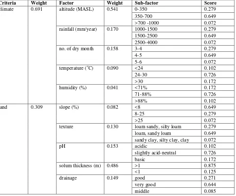
stated that AHP is able to simplify complex and unstructured elements into more organized elements. Land suitability parameter were organized into criteria, factors, and sub factors. The experts as resource persons from whom the criteria and factors were given score are the experts with expertise in bioenergy, cultivation, soil, and technology of kemiri sunan and possessed the field experience in the study of kemiri sunan. While the subfactor score is determined through the author scientific judgement referring to literature review results and kemiri sunan land suitability criteria. The criteria dan factor score was then analyzed using pairwaise comparisons with AHP to determine the weight. Criteria assessment was done using 1-9 comparison scale presented by Saaty (1991).The weight for criteria and factor provide value of Consistency Ratio 0.00 can be found completely in Table 2.
Table 2. The Weight for criteria and factor in kemiri sunan land suitability analysis
Criteria Weight Factor Weight Sub-factor Score
climate 0.691 altitude (MASL) 0.541 0-350 0.279
350-700 0.649
>700 -1000 0.072
rainfall (mm/year) 0.170 1000-1500 0.279
1500-2500 0.649
texture 0.130 loam sandy, silty loam 0.279 loam, sandy loam 0.649
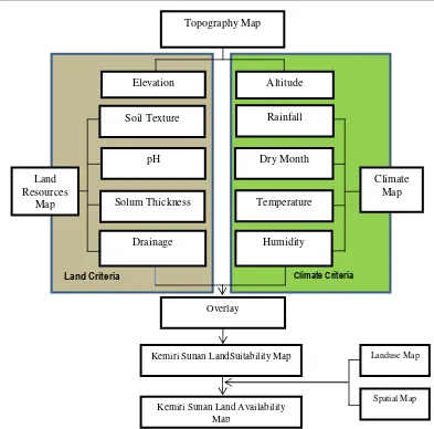
The suitable land for kemiri sunan need to be integrated with land use map and spatial map to exclude the lands which are not permitted to be planted by kemiri sunan crop. Land attached with strategic function will be retained to its function. Based on land use map, The West Java Province is divided into several land use which are forest, mixed farms, mangrove, plantation, settlement, swamp, paddy field, shrub, pond, bared land, dry land agriculture, and water body. West Java Spatial consist of conservation area, forest utilization area, disaster hazard area, protected forest conservation, rural area, urban area, paddy field, and water body.
Figure 1. Steps for Kemiri Sunan Land Availability Analysis
4. Results and Discussion
4.1 Results
4.1.1 Classification of land and climate characteristic
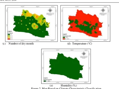
Classification of land and climate characteristic is needed to analyze land suitability, is depicted in 9 maps which are location altitude map, annual rainfall map, dry month map, air temperature map, air humidity map, slope map, soil texture map, pH map, solum thickness map and drainage map. Every map describing area condition spread that suits the determined criteria. Climate characteristic classification is presented in Figure 2.
(a) Altitude (MASL) (b) Yearly Rainfall (mm) Soil Texture
pH
Solum Thickness
Drainage Humidity
Temperature Dry Month
Rainfall
Land Resources
Map
Climate Map
Spatial Map
Topography Map
Kemiri Sunan LandSuitability Map Overlay
Kemiri Sunan Land Availability Map
Landuse Map
Altitude Elevation
(c) Number of dry month (d) Temperature (oC)
(e) Humidity (%)
Figure 2. Map Based on Climate Characteristic Classification
West Java Province is dominated by area with altitude < 350 m asl, rainfall 1500-4000 mm and number of dry month < 3. The condition related to temperature in West Java Province which mostly at 24-30o C and air humidity 71-88%. Land characteristic classification is presented in Figure 3.
(a)Slope (%) (b) Soil Texture
(e) Drainage
Figure 3. Map Based on Land Characteristic Classification
West Java Province is dominated by land with slope < 2%, pH slightly acid – neutral, and medium drainage. While solum thickness generally > 1 m with loam texture.
4.1.2 Land suitability class, area and spread of available land for planting kemiri sunan at West Java Province Based on overlay (weighted sum) and calculation by field calculator, resulted in the range of land suitability with 4 land suitability class as shown in Table 3.
Table 3. Kemiri sunan land suitability class
Suitability class Range
Suitable (S1) 0.542-0.693
Moderately suitable (S2) 0.390-0.542
Marginally suitable (S3) 0.239-0.390
Not Suitable (N) 0-0.239
The map of land suitability for planting kemiri sunan is the result of overlay (weighted sum) of map of climate parameter and land parameter. Kemiri sunan land suitability map is shown in Figure 4.
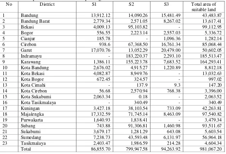
The suitable land for planting kemiri sunan is 981,067.20 Ha which consist of 86,855.70 Ha land of land suitability class in slightly suitable category, 799,947.58 Ha land of land suitability class in moderately suitable category, 94,263.92 Ha land in marginally suitable category. Spread of land area that are suitable for planting kemiri sunan in districts of West Java Province is shown in Table 4.
Table 4. Spread of available land for planting kemiri sunan at district on West Java Province
No District S1 S2 S3 Total area of
suitable land
1 Bandung 13,912.12 14,090.26 15,481.49 43,483.87
2 Bandung Barat 2,779.34 2,571.05 8,267.02 13,617.41
3 Bekasi 4,009.13 95,103.82 - 99,112.95
4 Bogor 556.55 2,223.14 2,557.03 5,336.72
5 Cianjur 185.78 - 1,096.36 1,282.14
6 Cirebon 938.6 67,368.50 16,761.34 85,068.44
7 Garut 17,070.76 13,052.29 20,479.00 50,602.05
8 Indramayu - 183,220.37 2,293.10 185,513.47
9 Karawang 1,386.11 155,223.78 7,683.52 164,293.41
10 Kota Bandung 2,676.02 4,915.27 1,220.89 8,812.18
11 Kota Bekasi 4,082.87 8,949.76 - 13,032.63
12 Kota Bogor 672.45 324.57 - 997.02
13 Kota Cimahi - 137.9 9.3 147.20
14 Kota Cirebon 56.68 2,570.94 768.38 3,396.00
15 Kota Sukabumi 2,063.34 0.18 - 2,063.52
16 Kota Tasikmalaya - 340.49 - 340.49
17 Kuningan 3,427.18 38,103.54 733.09 42,263.81
18 Majalengka 17,332.59 71,745.14 8,463.09 97,540.82
19 Purwakarta 1,640.93 1,838.41 - 3,479.34
20 Subang 743.88 91,306.81 1,460.98 93,511.67
21 Sukabumi 3,679.17 1,281.29 643.08 5,603.54
22 Sumedang 7,238.73 43,593.48 6,131.97 56,964.18
23 Tasikmalaya 2,403.47 1,986.59 214.28 4,604.34
Total 86,855.70 799,947.58 94,263.92 981,067.20
4.1.3 Area and spread of land available for planting kemiri sunan on West Java Province
Figure 5. Kemiri Sunan Land Availability Map in The Province of West Java
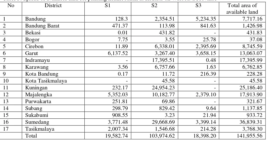
Available land for planting kemiri sunan is 141,955.56 Ha which consist of 19,582.74 Ha of land with suitability class in suitable category, 103,974.62 Ha land in moderately suitable category, 18,398.20 Ha land in marginally suitable category. Spread of available land for planting kemiri sunan at districts on West Java Province is shown in Table 5.
Table 5. Spread of available land for planting kemiri sunan at districts on West Java Province
No District S1 S2 S3 Total area of
available land
1 Bandung 128.3 2,354.51 5,234.35 7,717.16
2 Bandung Barat 471.37 113.98 841.63 1,426.98
3 Bekasi 0.01 431.82 - 431.83
4 Bogor 7.75 3.55 25.78 37.08
5 Cirebon 11.89 6,338.01 2,395.69 8,745.59
6 Garut 6,137.52 3,267.40 3,658.15 13,063.07
7 Indramayu - 17,395.51 0.48 17,395.99
8 Karawang 3.56 6,757.66 1.63 6,762.85
9 Kota Bandung 0.17 11.72 216.39 228.28
10 Kota Tasikmalaya - 45.58 - 45.58
11 Kuningan 232.17 24,954.23 - 25,186.40
12 Majalengka 5,352.03 10,182.77 2,379.10 17,913.90
13 Purwakarta 251.81 69.86 - 321.67
14 Subang 298.79 829.42 9.64 1,137.85
15 Sukabumi 908.55 3.23 21.94 933.72
16 Sumedang 3,771.48 29,668.69 3,399.14 36,839.31
17 Tasikmalaya 2,007.34 1,546.68 214.28 3,768.30
Total 19,582.74 103,974.62 18,398.20 141,955.56
4.2 Discussion
growth of kemiri sunan. Kemiri sunan grows well on rainfall 1500-2500 mm. Another climatic factors affecting based on numerical weight are in consecutive numbers of dry month, temperature, and humidity. While on land criteria, solum thickness has the greatest numerical weight. According to Supriadi et al., (2009) kemiri sunan grows well in soil with thick solum to rather thick. Solum thickness or the effective depth of the soil affecting plant growth and rooting. Winarso (2005) stated that soil depth will affect plant growth in terms of media volume to fulfill the water needs, nutrients and rooting process. Akinci et al., (2013) stated that soil depth is important factor that effecting soil hidrology character and behavior to resist erosion. In addition to solum thickness, soil pH is another influencing factor. Winarso (2005) defined pH as matter’s relative acidity or basicity. Soil pH is a defining factor for microorganism activity and domination. Other influencing land factor based on numerical weight are in consecutive drainage, soil texture, and slope. Ismail et al., (2012) using soil drainage factor to determine land suitability in various type of land use at Western Dessert, Egypt. One of the result is that soil drainage is the limiting factor for land use type of surface irrigation land. According to Curcio et al., (2013) soil texture has its role in soil degradation process and water transportation also in control of soil quality and productivity.
Area of suitable land for planting kemiri sunan at West Java Province is 981,067.20 Ha or 25.7% of total West Java Province area. The suitable land are spread in 23 districts on West Java Province. Land utilization for planting kemiri sunan should pay attention to the West Java Province landuse and spatial planning. Land use planning is an important factor. Jie et al., (2010) stated that land use planning has important role in resources distribution and land use organization.
Land use for forest is not led towards development of kemiri sunan due to its strategic function for West Java Province. Forest in West Java is included to conservation area to maintain the sustainability of environmental function, environment carrying capacity and to support sustainable development. Meanwhile plantation and paddy field are cultivation area to support economic growth and food needs. Plantation in West Java plays a big role in developing agricultural sector, both for government-owned large estate as well as private and people’s estate. In year 2013 lahan paddy fields in West Java produced 60.78 kuintal/Ha rice and cultivated land produce 41.44 kuintal/Ha of rice. (BPS, 2014). Conservation area, conservation area for protected forest, urban, paddy field, and water body are spatial pattern that should remain for its important function to West Java Province particularly for agricultural sector and environmental sustainability, thus they were excluded from kemiri sunan land availability calculation. Land use that are potential for kemiri sunan planting are mixed farm, shrub, bared land, and dry land agriculture. For that consideration, the area that could be planted with Kemiri Sunan with regards to other land use and landuse planning is 141,955.56 Ha, in details suitable area is 19,582.74 Ha, moderately suitable 103,974.62 Ha, and marginally suitable 18,398.20 Ha. The area of available land is spread in 17 districts on West Java Province. Districts with significant area of available land consecutively are district of Sumedang, Kuningan, Majalengka, Indramayu, and Garut. Herman et al., (2013) stated that Majalengka and Garut possessed yield block of kemiri sunan plant height. Kemiri sunan from Banyuresmi population at Garut and kemiri sunan from Jumat population at Majalengka has been established as prominent variety of kemiri sunan.
Table 6. Kemiri sunan land availability calculation
799,947.58 21.78 649,279.91 46,693.05 103,974.62 2.83 3 Marginally
suitable (S3)
94,263.92 2.57 55,094.74 20,770.98 18,398.20 0.50 Total S 981,067.20 25.71 757,263.99 81,847.65 141,955.56 7.12 4 Not suitable (N) 2,691,512.75 73.29 757,263.99 81,847.65 1,852,401.11 92.88 Total S + N 3,672,579.95 100.00 1,514,527.98 163,695.30 1,994,356.67 100.00
*1)
Based on landuse map of West Java Province 2012 *2)
Based on RTRWP 2010-2030 map of West Java Province
4. Conclusions and Recommendations
The area of suitable land for planting kemiri sunan is 981,067.20 Ha which consist of 86,855.70 Ha of land in slightly suitable category, 799,947.58 Ha of land in moderately suitable category, 94,263.92 Ha of land in marginally suitable category. The suitable land area is spread in 23 districts on West Java Province. While available potential land for planting kemiri sunan after deduction by area allocated for another use is 141,955.56 Ha which consist of 19,582.74 Ha of land in suitable category, 103,974.62 Ha land in moderately suitable category, and 18,398.20 Ha of land in marginally suitable category. Area of available land is spread in 17 districts on West Java Province. Kemiri sunan is recommended for development at West Java Province as an effort for providing alternative energy and environment rehabilitation.
Acknowledgements
The authors are grateful to all experts for giving informations and opinions in the AHP. We are also grateful to Abdul Halim for assisting in the GIS analysis.
References Romania. Procedia Economics and Finance 8, 300 – 305.
Domac, J., K. Richards, S. Risovic. (2005). Socio-economic Drivers in Implementing Bioenergy Project. Biomass and Bioenergy 28, 97-106.
Herman, M., M. Syakir, D. Pranowo, Saefudin, Sumanto. (2013). Kemiri Sunan (Reutealis trisperma (Blanco) Airy Shaw) Tanaman Penghasil Minyak Nabati dan Konservasi Lahan. Jakarta (ID): IAARD Pr.
Ismail. M,. M.K. Abdel Ghaffar, M.A. Azzam. (2012). GIS Application to Identify the Potential for Certain Irrigated Agriculture Uses in Some Soils in Western Desert, Egypt. The Egyptian Journal of Remote Sensing and Space Sciences 15, 39-51.
Jie, L., Y. Jing, Y. Wang,Y. Shu-xia. (2010). Environmental Impact Assesment of Land Use Planning in Wuhan. Procedia Environment Sciences 2, 185-191.
Kusumaningrum, W.B., S.S. Munawar. (2014). Prospect of Bio-pellet as an Alternative Energy to Subtitute Solid Fuel Based. Energy Procedia 47, 303-309.
Liu, T.T., B.G. McConkey, Z.Y. Ma, Z.G. Liu, X. Li, L.L. Cheng. (2011). Strengths, Weakness, Opportunities, and Threats Analysis of Bioenergy Production on Marginal Land. Energy Procedia 5, 2378-2386. Marimin, N. Maghfiroh. (2011). Aplikasi Teknik Pengambilan Keputusan Dalam Manajemen Rantai Pasok.
Bogor (ID): IPB Pr.
Roos, A., R.L. Graham, B. Hektor, & C. Rakos. (1999). Critical Factors to Bioenergy Implementation. Biomass and Bioenergy 17, 113-126.
Saaty, T.L. (1991). Pengambilan Keputusan bagi Para Pemimpin: Proses Hirarki Analitik untuk Pengambilan Keputusan dalam Situasi yang Kompleks (terjemahan). Jakarta (ID): PT. Pustaka Binaman Pr.
Salim, Z. (2009). Strategi dan Kebijakan Pengembangan Industri Biodiesel di Beberapa Negara. Di dalam Bunga Rampai Hasil Penelitian Pengembangan Industri Energi Alternatif : Studi Kasus Industri Biodiesel. Jakarta : LIPI Pr. pp 21-67.
Supriadi, H., K.D. Sasmita, & Usman. (2009). Tinjauan Agroklimat Wilayah Pengembangan di Jawa Barat. Di dalam Kemiri Sunan Penghasil Biodiesel : Solusi Masalah Energi Masa Depan. Bogor. Balai Penelitian Tanaman Rempah dan Aneka Tanaman Industri. pp 73-80.
Utomo, W.Y. 2013. Analisis Potensi Rawan (Hazard) dan Resiko (Risk) Bencana Banjir dan Longsor (Studi Kasus Provinsi Jawa Barat). [tesis]. Bogor(ID): Institut Pertanian Bogor.