The Effect of UNBabc Mapping Function Modification To GPS
Tropospheric Delay
1
Hamzah Sakidin , 1Mohd Rizam Abu Bakar, 2Abdul Rashid Mohamed Shariff, 3Mohd Salmi Md Noorani, 4Abd. Nasir Matori,
5
Azhari Mohamed, 6Asmala Ahmad
1
Dept. of Mathematics, Faculty of Science, Universiti Putra Malaysia 2
Faculty of Engineering, Universiti Putra Malaysia 3
Faculty of Science and Technology, Universiti Kebangsaan Malaysia, 4
Faculty of Civil Engineering, Universiti Teknologi Petronas 5
Department of Survey and Mapping Malaysia, Kuala Lumpur 6
Faculty of Information Technology and Computer, Universiti Teknikal Malaysia Melaka.
ABSTRACT
Tropospheric delay refers to the refraction of the Global Positioning System (GPS) signal as it passes through the neutral atmosphere from the satellite to the earth, which causes longer distance traveled by the signal. The zenith tropospheric delay can be amplified by mapping function, especially for less than 5 degrees elevation angle. Many mapping functions have been established however the mapping functions give large value when the elevation angles less than 5 degrees. A modification of UNBabc mapping function has been proposed. The modified UNBabc mapping function model shows a significant reduction of mapping function scale factor. As the coefficient of the zenith tropospheric delay, the value of mapping function will affect total tropospheric delay. The modification UNBabc mapping function has improved the tropospheric delay up to 19.1 percent at two degree elevation angles.
Keywords: Tropospheric, mapping function, zenith, modification
INTRODUCTION
Zenith Hydrostatic delay (ZHD) x mapping function
Tropospheric delay
Atmospheric Zenith wet delay (ZWD) x mapping
delay function
Ionospheric delay .
Figure 1: Atmospheric signal delay structure
At zenith direction, tropospheric delay contributes about 2.5m (Ahn, 2005). Hydrostatic (dry) delay contributes 90% and wet delay contributes about 10% of the tropospheric delay (Leick, 1995). This hydrostatic component has a smooth, slowly time-varying characteristic due to its dependence on variations in surface air pressure (weather cells). So this part can be modeled and removed with an accuracy of a few millimeters or better using a surface model (including pressure, temperature and humidity). It does not therefore create much of a problem as far as its effect on GPS signals (El Rabbany, 2002). Although wet delay is much smaller than the hydrostatic component but the uncertainties in wet tropospheric delay modeling do place a great burden on high precision GPS applications.
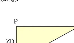
Referring to Figure 2, the tropospheric delay is the shortest in zenith direction (when the satellite at P) and becomes larger with the increase of zenith angle (at Q).
Figure 2: Illustration for obliquity factor (mapping function) between zenith and slant direction
Projection of zenith path delays into slant direction is performed by application of a mapping function or obliquity factor, m(z)that is defined as (Schuler, 2001):
ZD
TD
z
( ) TD m z
ZD
=
(1)
where : TD – total tropospheric delay (slant neutral delay), ZD – total zenith delay,
ε
- elevation angle (from ground to satellite). z - zenith angle (z = 90 -ε )From Figure 2 above, z TD
ZD
cos
= (2)
By substitution into (2), z z
z
m sec
cos 1 )
( = = (3)
Unfortunately, this secant model is only an approximation assuming a planar surface of the earth and not taking the curvature of the earth into account (Saastamoinen, 1972). The tropospheric delays (TD) at arbitrary elevation angles can be expressed in terms of the zenith delays (ZD) and mapping functions
m
(
z
)
as given below:×
=ZD
TD
mapping function
×
=ZD
TD
mapping function
(4)However, ZD can be separated into two components such as a hydrostatic component (zenith hydrostatic delay, ZHD) and a wet component (zenith wet delay, ZWD).
)
(
)
(
ZHD
ZWD
m
z
TD
=
+
∗
(5)
)
(
)
(
ε
wε
h
ZWD
m
m
ZHD
TD
=
×
+
×
(6)
where :
ZHD is zenith hydrostatic delay (m) ZWD is zenith wet delay (m)
h
m
( ) is the hydrostatic mapping function (no unit)w
m
( ) is the wet mapping function (no unit)The objectives of the study are to modify the model of UNBabc mapping function and also to investigate its effectiveness by calculating the tropospheric delay to get the improvement for hydrostatic delay model and also non hydrostatic delay model based on the original UNBabc mapping function.
UNBabc MAPPING FUNCTION
UNBabc is a tropospheric mapping function established by Jiming Guo from the University of New Brunswick (Guo, 2003) using ray tracing delay values, which has a 3-terms continued fraction form as shown in equation [7] below:
i i i
i i i
i
c
b
a
c
b
a
m
+
+
+
+
+
+
=
ε
ε
ε
ε
sin
sin
sin
1
1
1
)
(
(7)where i = h or nh
ε
- elevation angle (90 – z)h
m
- hydrostatic mapping functionnh
From a series of analyses, parameter
a
i is sensitive to the orthometric height, and latitude, φ of the station whereas parameters and could be represented by constants. The least-squares estimated parameters for the hydrostatic function are:h
a
= (1.18972 - 0.026855 + 0.10664 cos φ)/1000h
b
= 0.0035716h
c
= 0.082456and for the non-hydrostatic component:
nh
a
= (0.61120-0.035348 -0.01526 cos φ)/1000nh
b
= 0.0018576nh
c
= 0.062741In this study, modification of UNBabc mapping function has been carried out by only focusing on the denominator of equation [7], whereby the third sine function term to be changed with cosine function while the rest of the mapping function remain unchanged.
The calculation of reduction percentage will show the improvement of the modified mapping function. Both current and modified mapping functions will be multiplied by zenith tropospheric delay value to get the hydrostatic and non hydrostatic components delay. The summation of the hydrostatic and non hydrostatic components will give the total tropospheric delay in meter for both the current and modified tropospheric delay.
As the coefficient of the zenith tropospheric delay, the mapping function values should be smaller in order to get smaller tropospheric delay. The scale factor value at 90 degrees elevation angle should be unity.
mapping function for hydrostatic component and modified UNBabc(nh) mapping function for non hydrostatic component, as given in equation [8] below: i i i i i i i
c
b
a
c
b
a
m
+
+
+
+
+
+
=
ε
ε
ε
ε
cos
sin
sin
1
1
1
)
(
(8)whereby all the other terms remain unchanged as given in equation (7).
MATHEMATICAL JUSTIFICATION FOR CHANGING FROM
SINE FUNCTION TO COSINE FUNCTION
The UNBabc mapping function models for both hydrostatic and non hydrostatic are given as follows:
It is true that cos
ε
>sinε
for 0<ε < 4π
c
c> +
+
ε
ε
sincos when
c
is constant,c b c b + < +
ε
ε
sincos when bis constant,
c b c b + + < + +
ε
ε
ε
ε
sin sin cos sin,
c
b
a
c
b
a
+
+
>
+
+
ε
ε
ε
ε
sin
sin
cos
sin
when
a
is constant,sin sin sin sin cos sin A A a a b b c c ε ε ε ε ε ε < + + + + + +
when A is constant
If
c
b
a
A
+
+
+
=
1
1
1
,so that equation (6) < equation (7) as given below:
c b a c b a c b a c b a + + + + + + < + + + + + +
ε
ε
ε
ε
ε
ε
sin sin sin 1 1 1 cos sin sin 1 1 1is always true for 0<ε < 4
π
Equation (8) can give smaller value than equation (7) for 0<ε < 4
π
. So,
equation (8) has been used as modified UNBabc mapping function for both hydrostatic and non hydrostatic models.
Equation (8) can give smaller value than equation (7) for 0<ε < 4
π
. So,
COMPARISON BETWEEN THE UNBabc MAPPING
FUNCTION AND MODIFIED UNBabc MAPPING FUNCTION
To compare the effectiveness between the UNBabc and modified UNBabc mapping function, the scale factor values will be calculated to show the reduction for both mapping functions as described below.
Hydrostatic component
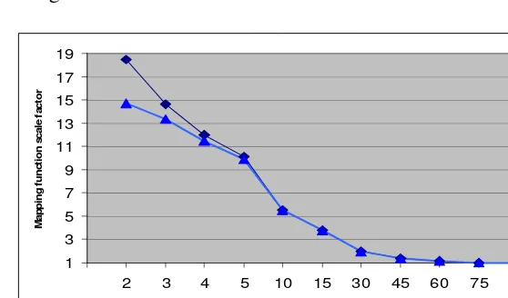
Modified UNBabc(h) mapping function as given in equation [8] is compared with UNBabc(h) mapping function as given in equation [7] as shown in Figure 3 below:
1 3 5 7 9 11 13 15 17 19
2 3 4 5 10 15 30 45 60 75
Elevation angle, E (de gre e)
M
a
p
p
in
g
f
u
n
c
ti
o
n
s
c
a
le
f
a
c
to
r
UNBabc(h) Modif ied UNBabc(h)
Figure 3: Comparison between the UNBabc(h) and the modified UNBabc(h) combination
From Figure 3, the modified UNBabc(h) graph shows that at the elevation angles of less than 5 degrees, its scale factors are much smaller. For elevation angles more than 5 degrees, its scale factors are quite similar to the original UNBabc(h) model. However, at elevation angle of 90 degree, its scale factor is unity.
Non hydrostatic component
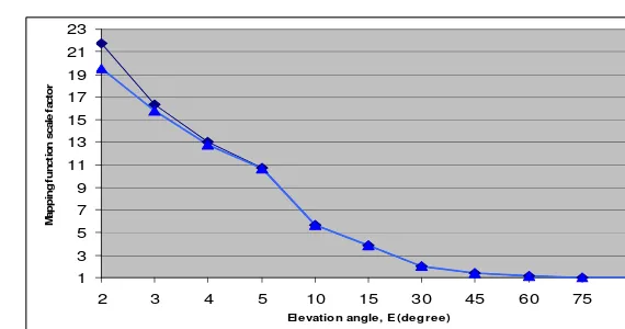
1 3 5 7 9 11 13 15 17 19 21 23
2 3 4 5 10 15 30 45 60 75 90
Ele vation angle , E (de gre e )
M
a
p
p
in
g
f
u
n
c
ti
o
n
s
c
a
le
f
a
c
to
r
UNBabc(nh) Modif ied UNBabc(nh)
Figure 4: Comparison between the UNBabc(nh) and modified UNBabc(nh)
From Figure 4, the modified UNBabc(nh) shows that at the elevation angles of less than 5 degrees, its scale factors are much smaller. For elevation angle more than 4 degree, its scale factors are quite the same with UNBabc(nh) model. However, at the elevation angle of 90 degrees, its scale factor is unity.
IMPROVEMENT OF TROPOSPHERIC DELAY (TD)
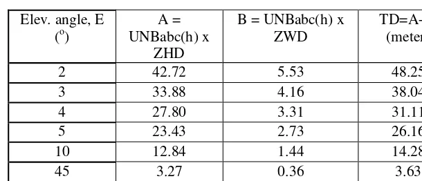
The improvement of tropospheric delay can be shown by comparing the tropospheric delay value. The calculation for tropospheric delay will use equation (1) as given previously. The values for ZHD = 2.31m and ZWD = 0.25m can be calculated from Saastamoinen Tropospheric delay model (Saastamoinen, 1972).Tropospheric delay using UNBabc mapping function
TABLE 1 : Tropospheric delay (TD) using UNBabc mapping function
Elev. angle, E (o)
A = UNBabc(h) x
ZHD
B = UNBabc(h) x ZWD
TD=A+B (meter)
2 42.72 5.53 48.25
3 33.88 4.16 38.04
4 27.80 3.31 31.11
5 23.43 2.73 26.16
10 12.84 1.44 14.28
45 3.27 0.36 3.63
90 2.31 0.25 2.56
Table 1 shows that the elevation angle starts from 2 degree until 90 degree. At 90 degree, the tropospheric delay give the standard values (2.31m for hydrostatic and 0.25m for non hydrostatic) due to the value of mapping function for both components at 90 degree is unity, 1.
Tropospheric delay using modified UNBabc mapping function
The results of calculation of tropospheric delay for UNBabc(h) for both components can be shown in Table 2 below:
TABLE 2 : Tropospheric delay (TD) using modified UNBabc(nh) mapping function
Elev. angle, E
(o)
C = modified UNBabc(nh) x ZHD
D = modified UNBabc(nh) x
ZWD
TD = C + D (meter)
2 34.08 4.97 39.05
3 30.87 4.01 34.88
4 26.61 3.25 29.86
5 22.9 2.71 25.61
10 12.81 1.44 14.25
45 3.27 0.36 3.63
90 2.31 0.25 2.56
for hydrostatic and 0.25m for non hydrostatic) due to the value of mapping function for both components at 90 degree is unity, 1.
Improvement percentage for Tropospheric Delay (TD)
The improvement of tropospheric delay can be shown by comparing between modified UNBabc mapping function and UNBabc mapping function. As coefficient to the zenith delay, the improvement in mapping function will directly affect the total tropospheric delay.
Current TD is calculated using UNBabc mapping function and New TD is calculated using modified UNBabc mapping function. The improvement of the tropospheric delay can be shown in Table 3 and Figure 5 below:
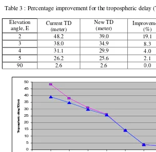
Table 3 : Percentage improvement for the tropospheric delay (TD)
Elevation angle, E
Current TD (meter)
New TD (meter)
Improvement (%)
2 48.2 39.0 19.1
3 38.0 34.9 8.3
4 31.1 29.9 4.0
5 26.2 25.6 2.1
90 2.6 2.6 0.0
0 5 10 15 20 25 30 35 40 45 50
2 3 4 5 10 45 90
Ele vation angle, E (degree)
T
ro
p
o
s
p
h
e
ri
c
d
e
la
y
,T
D
(
m
)
Current TD (meter) New TD (meter)
Table 3 shows that the elevation angle starts from 2 degree until 90 degree. For the elevation angles of more than 5 degree, the different tropospheric delay between both models is too small and not significant. Figure 5 shows that the difference between the current tropospheric delay and new tropospheric delay can be seen when the elevation angle is less than 5 degree.
CONCLUSION
For the elevation angles less than 5 degrees, the reduction percentage of the tropospheric delay is very obvious, especially for two degrees elevation angles. On the other hand, the reduction shows the significant improvement of the mapping function, either for hydrostatic or non hydrostatic mapping functions. As the amplifier effect (coefficient) to the zenith tropospheric delay, the improvement can directly reduce the total tropospheric delay of the GPS signal.
Modified UNBabc mapping function contributes 19.1 percent to the tropospheric delay improvement percentage at two degree elevation angle. The results show that the modified UNBabc mapping function is a suitable choice to be an alternative mapping function, for replacing the original UNBabc mapping function for both components, hydrostatic and also non hydrostatic.
REFERENCES
Ahn, Y.W. 2005. Analysis of NGS CORS Network for GPS RTK Performance Using External NOAA Tropospheric Corrections Integrated with a Multiple Reference Station Approach, M.Sc. Theses, University of Calgary, Canada.
El-Rabbany, A. 2002, Introduction To GPS: Global Positioning System. Artech House mobile communication series, Boston, London.
Leick, Alfred. 1994. GPS Satellite Surveying, 2nd Edition, John Wiley & sons, 1994, USA.
Saastamoinen, J.1972. Atmospheric correction for troposphere and stratosphere in radio ranging if satellites, Geophysical monograph, 15, American Geophysical Union, Washington, D. C., USA, pp. 247-252, 1972.