Rain Height Information from TRMM Precipitation
Radar for Satellite Communication in Malaysia
M.A. Nor Azlan1 , Din.J2, H.Y. Lam3 1
Department of Telecommunication Engineering, Faculty of Electronic and Computer Engineering, Universiti Teknikal Malaysia, Hang Tuah Jaya, 76100 Durian Tunggal, Melaka, Malaysia
email: [email protected] 2,3
Department of Radio Communication Engineering, Faculty of Electrical Engineering, Universiti Teknologi Malaysia, Skudai 81310 Johor, Malaysia
email: [email protected], [email protected]
Abstract— Tropical and equatorial region exhibits significantly higher rainfall rate with regard to temperate region leading to extreme attenuation for satellite communication links. One relevant issue for radiowave propagation modeling in this particular region is the different structures of precipitation which play an important role in estimating rain fade. To this aim, an investigation of the rain characteristics of 0°C isotherm height in Malaysia derived from the precipitation radar on-board the TRMM (Tropical Rainfall Measuring Mission) satellite has been carried out. In fact, TRMM satellite precipitation radar appears as one of the powerful source of instrument in meteorology and telecommunication in estimating height of rainfall in tropical/equatorial region. In this work, one year of TRMM radar data have been analyzed from the stratiform rain event which there usually exists a well defined melting layer (or bright band). These results are then compared with the radiosonde measurement and ground meteorological radar obtained from earlier publication, together with the mean 0°C isotherm height given in the ITU-R Recommendation P.839. Comparisons show that the freezing heights typically occurred at the height higher than 4.5 km as recommended by ITU-R Recommendation P.839. The preliminary results suggest that by carefully consider the physical information of rain height derived from the various local databases should lead to substantial improvements in the rain attenuation prediction accuracy for equatorial and tropical region.
Keywords- Rain height;Bright-band height;0oC isotherm height; TRMM PR;equatorial; tropical.
I. INTRODUCTION
Satellite communication links operating at frequencies above 10 GHz are affected immensely by hydrometeors such as rainfall [1]. This effect are expected to be quite severe in the tropical and equatorial regions such as Malaysia due to the significantly higher rainfall rate with regard to the temperate region. Therefore, several important local parameters deal with the estimation of rain attenuation are extremely critical for the design of earth-space links in these region as recommended by the well known prediction model from ITU-R P.618-10 [2]. One of the parameter which plays important role in estimating attenuation due to rain is the height up to the rain occurs. To this end, extensive studies on the rain height have been carried more than a decade. In fact, International Telecommunication
Union (ITU) recomended a fixed value of rain height which currently estimated in relation to the 0oC isotherm level inferred from ITU-R P.839-3 for different climatology regions
[3]. However, studies carried out by Mandeep [4] in Malaysia using radiosonde revealed that the 0oC isotherm height exhibits seasonal variations which suggests the height of rain might vary throughout the year. In addition, rain height retrived from ground precipitation radar near Malaysia (Singapore) was also deliberated previously by M. Thurai et al. [12]. It is worth mentionning that, apart from the instruments mentioned above can be employed to measure rain height, Tropical Rainfall Measuring Mission (TRMM) satellite appear as one of the alternative instrument that can be used to served such research requirement. Hence, it will be interesting to investigate the applicability of TRMM in rain height information retrieval, as well as cross validation of the radiosonde and ground radar performances.
Tropical Rainfall Measuring Mission (TRMM) satellite is considered one of the most powerful equipment for meteorological study in the tropics. The TRMM satellite is operative since 1997 and consists of five sensors on board which are Precipitation Radar (PR), TRMM Microwave Imager (TMI), Visible and Infrared Scanner (VIRS), Cloud and Earth Radiant Energy Sensor (CERES), and Lightning Imaging Sensor (LIS) [5]. The most important sensors on board TRMM satellite is Precipitation Radar (PR) where it is the first spaceborne radar that can directly observe vertical structure of rain [6].
The objectives of this paper are to analyze the variation of rain height in Malaysia throughout a year and to validate the rain height estimated from TRMM PR with measurement data from radiosonde observation and ground-based radar data. The paper is organized as follows; Section II describes the defination of rain height as well as rain type classification. The parameter in relation to the rain height are also discussed. Section III presents some results and discussions on rain height variability throughout the year, extracted from TRMM PR and compared with the radiosonde observation, ground-based radar, as well as ITU-R Recommendation P.839-3. Finally, conclusion is drawn in Section IV.
Proceeding of the 2011 IEEE International Conference on Space Science and Communication (IconSpace) 12-13 July 2011, Penang, Malaysia
II. RAINHEIGHT
A. Rain height description
As previously mentioned, rain height differs based on climatic differences. It usually represents the boundary between rain region and snow region [7] and sometimes it is referred to the level at which water drop larger than 0.1 mm present [8]. In principle, rain height plays an important role in radiowave propagation modeling and designed related to rain.
For instance, several ITU-R recommendations also use rain height as an input parameter in their step-by-step methods for evaluating the various impairments such as [7]:
1. ITU-R Recommendation P.618-10 (dealing with earth space attenuation).
2. ITU-R Recommendation P.452-14 (dealing with co-channel interference).
3. ITU-R Recommendation P.620-6 (dealing with co-ordination distances).
4. ITU-R Radio Regulation Appendix 7 (dealing with regulatory issues of co-ordination.
The following point deserve to be cited. The physical rain height not necessarily the same as the effective rain height. It depends on the type of rain. According to Thurai et al. in [7], stratiform rain may be assumed to extend up to 0oC isotherm height. However, convective rain could extend more than the 0oC isotherm height and sometimes reach more than 10 km due to strong updrafts. Following these criteria, in this paper, we concentrate only on the effective rain height estimated from bright-band of stratiform rain as the melting layer would lead to an extra attenuation and can be clearly observed between the boundary of ice and water region
B. Rain type classification
In general, radio wave propagation modeling classified the precipitation into two main types, namely stratiform and convective. The differences between stratiform and convective rain typically rain height contribute substantial impact in the attenuation prediction accuracy [9].
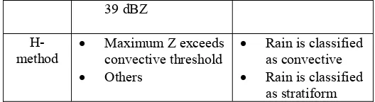
In this paper, the rain height information is extracted according to the TRMM PR algorithm which classified the rain type based on the two method as explained in Chandrasekar et al. [10]. These methods are named Vertical profile method (V-method) and Horizontal Pattern Method (H-method). V-method detects the existence of bright-band while H-method examines the horizontal pattern of reflectivity at a given height. The algorithm simplified is shown in Table I below. Further details of TRMM PR rain type algorithm are discussed in detail by J. Awaka et al.[11].
Table I. Simplified rain type classification algorithm
Method Indication Description
V-method
• Bright-band detected
• Bright-band not detected and maximum Z exceeds
• Rain is classified as stratiform • Rain is classified
as convective
39 dBZ
H-method •
Maximum Z exceeds convective threshold • Others
• Rain is classified as convective • Rain is classified
as stratiform
C. Bright-band and 0oC isotherm relation to the rain height
Bright-band and 0oC isotherm often lie close to each other although both are indicating different parameter. As explained by M. Thurai et al. [12], bright-band can be detected through vertical profile of radar reflectivity. As shown in Figure 1, the occurrence of bright-band or melting layer is seen through peak value of radar reflectivity at certain height. It happens typically due to ice crystal melting into rain and will only be detected during stratiform event [7], [10], [13]. The melting process usually started just below the 0oC isotherm height. The height of maximum reflectivity vary depending on the climatic region [8].
Figure 1. Typical radar reflectivity vertical profile [7]
Various researches has been done by M. Thurai et al. [7],
[12], [14] on the band height which indicates the bright-band height is depended on the 0oC isotherm height and vice versa [15]. 0oC isotherm height usually lies about 200-300 m above the bright-band. It can be as high as 500 m as mentioned by J. Awaka et al. [13] and M. Thurai et al. [14]. On the other hand, ITU-R Recommendation P.839-3 provides yearly average data for 0oC isotherm height to be used in the ITU-R Recommendation P.618-10. From the 0oC isotherm height (h0), the effective rain height (hR) can be estimated by following equation [3]:
hR= h0 + 0.36 km (1) The 0oC isotherm height often used as a reference to estimate the height of rain. For example Ajayi et al. [8] study
on variation of 0oC isotherm height to evaluate the slant-path rain attenuation, while M. Thurai et al. [7] used information of 0oC isotherm height to estimate co-channel interference. In this work, TRMM PR 2A23 product has been exploit to revealed the estimated freezing level height which defined as 0oC isotherm height. Table II shows the 0oC isotherm height from various climatic region collected from the open literature:
Table II. Estimated value of 0oC isotherm height from various sources and locations
In section III-A, we present a distribution of bright-band over Malaysia and comparison of bright-band distribution is carried out between the information extracted from TRMM PR and measurement from ground-based radar. While in section III-B, we compare those rain height results with the open literature results obtained from several locations in Malaysia
A. Distribution of bright-band over Malaysia
Figure 2 shows monthly average variation of bright-band height in Malaysia obtained from TRMM product data from the year of 2007 Observed that average bright-band heights occured at altitude between 4192 m and 4593 m. It appears that the lowest height occurs during January and September which are the end month of Northeast and Southwest monsoon respectively. These results also suggest the seasonal dependence effect to the bright-band height
Figure 2. Monthly average variation of bright-band height .
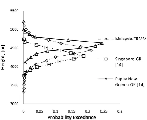
Figure 3. Comparison of bright-band height distribution from TRMM PR (in Malaysia) and ground-based radar data (in
Singapore and Papua New Guinea)
Figure 3 shows that the bright-band height distribution in tropical country namely Malaysia, Singapore and Papua New Guinea. As is clear from the figure, most of the bright-band height laid between 4000 m and 5000 m above mean sea level. Note that distribution of bright-band height in Malaysia is taken from TRMM PR measurement while Singapore and Papua New Guinea are using ground-based radar observation. The comparison immediately point out that, eventough the measurements are taken using independent equipment, it shows almost similar pattern of distribution. These cross-validation results reflects the capability of the both instrument with regards to the bright-band height determination.
B. Comparison of monthly average 0oC isotherm heights.
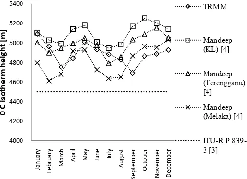
Figure 4. Annual distribution of monthly average 0oC isotherm heights from TRMM PR, radiosonde measurement and ITU-R
P.839-3
Figure 4 shows the comparison of 0oC isotherm height from TRMM PR with measurement data from radiosonde observation and ITU-R P.839-3. The 0oC isotherm height by TRMM PR is computed by assuming that it lies 500 m above the bright-band [13, 14]. Measurement data from radiosonde [4] are taken at 3 different locations; Kuala Lumpur, Terengganu and Melaka. It it worth being underlined that the 0oC isotherm height not only vary on monthly basis but somehow differ according to the location. This variation is most probably ascribed by the local climatology characteristics in equatorial region which is associated with local convection. In addition, good agreement to each measurements results taken by two independent equipments seems to confirm the efficiency of both instrument . As a matter of fact, this results suggests that the design of satellite link should carefully consider local values of rain height.
IV. CONCLUSIONS
The statistics of rain height over Malaysian equatorial station derived from spaceborne radar have been presented. Good agreement is obtained between TRMM PR measurement and radiosonde observation as well as ground-based radar. Such results seems to recognized the capability of TRMM used to identified rain height for the propagation studies. On the other hand, the results also marked the monthly variability of the rain height on monthly basis throughout a year. Locally dependent of rain height variability is of key importance to the system operator in determine adequate fade margin. Furthermore, ITU-R P.839-3 seems underestimated the real values of effective rain height in tropical/equatorial region particulary in Malaysia. Finally, from the preliminary results obtained in this work, we sugguest that in order to identified adequate fade margin , system operator should carefully considered local rain height information to achieved the
prescribed Quality of Services (QoS).Future work should further consider the vertical profile of rain height behaviour with respect to diurnal variability and types of precipitation.
ACKNOWLEDGMENT
The authors are grateful to Universiti Teknikal Malaysia (UTeM), Melaka and Ministry of Higher Education (MoHE) for financial support of the study. The authors also acknowledges the help and assistant from Dr. Lorenzo Luini of Politecnico di Milano.
REFERENCES
[1] A. Dissanayake, J. E. Allnutt, and F. Haidara, “A prediction model that combines rain attenuation and other propagation impairments along earth–satellite paths”, IEEE Trans. on Antenn. and Propag. 1997. 45(10): 1546–1558. 1997.
[2] ITU-R Recommendation P.618-10, “Propagation Data and Prediction Method Required for the Design of Earth-Space”, 2009.
[3] ITU-R Recommendation P.839-3, “Rain Height Model for Prediction Methods”, 2001.
[4] J. S. Mandeep, “Rain Height Statistics for Satellite Communication in Malaysia”, J. Atm. & Solar-Terr. Physics. 70: 1617-1620. 2008
[5] T. Kozu, T. Kawanishi, H. Kuroiwa, M. Kojima, K. Oikawa, H. Kumagai, K. Okamoto, M. Okumura, H. Nakatsuka, and K. Nishikawa. 2001, “Development of Precipitation Radar Onboard the Tropical Rainfall Measuring Mission (TRMM) Satellite”, IEEE Trans. on Geosc. & Remote Sensing. 39(1): 102-116. 2001.
[6] T. Kawanishi, H. Kuroiwa, M. Kojima, K. Oikawa, T. Kozu, H. Kumagai, K. Okamoto, M. Okumura, H. Nakatsuka, and K. Nishikawa, “TRMM Precipitation Radar”, Adv. Space Res. 25(5): 969-972. 2000. [7] M. Thurai, E. Deguchi, K. Okamoto, and E. Salonen, “Rain Height
Variability in the Tropics”, IEE Proc. Microw. Antennas Propag. 152(1): 17-23. 2005.
[8] G. O. Ajayi, and F. Barbaliscia, “Prediction of Attenuation Due to Rain: Characteristics of the 0oC Isotherm in Temperate and Tropical Climates”, Int. J. of Sat. Comm. 8: 187-196. 1990.
[9] C. Capsoni, L. Luini, A. Paraboni, C. Riva, and A. Martelluci, “A New Prediction Model of Rain Attenuation That Separately Accounts for Stratiform and Convective Rain”, IEEE Trans. On Antenn. and Propag. 57(1): 196-203. 2009
[10] V. Chandrasekar, and B. Zafar, “Precipitation Type Determination From Spaceborne Radar Observations”, IEEE Trans. On Geosc. & Remote
Sensing. 42(10): 2248-2253. 2004.
[11] J. Awaka, T. Iguchi, and K. Okamoto, “Early Results on Rain Type Classification by the Tropical Rainfall Measuring Mission (TRMM) Precipitation Radar”, Proc. 8th URSI Commission F. Open Symp. Aveiro,
Portugal. 143-146. 1998.
[12] M. Thurai, T. Iguchi, T. Kozu, J. D. Eastment, C. L. Wilson, and J. T. Ong, “Radar Observations in Singapore and Their Implications for the TRMM Precipitation Radar Retrieval Algorithms”. Radio Science. 38(5). 1-13. 2003.
[13] J. Awaka, T. Iguchi, and K. Okamoto, “TRMM PR Standard Algorithm 2A23 and its Performance on Bright Band Detection”, J. Meteorological
Soc. of Japan. 87A: 31-52. 2009.
[14] M. Thurai, and T. Iguchi, “Rain Height Information from TRMM Precipitation Radar”, Electronics Letters. 36(12): 1059-1061. 2000. [15] E. A. Brandes, and K. Ikeda, “Freezing-Level Estimation with