ISBN: 978-979-1266-18-5
MPULAN RISEr KELAUTAN
MENUJU SUMBERDA YA ALAM
YANG LESTARI
, --
...
セ@ N@ L セZNNN@
セ@
" GEO.MARINE RESEARCH FORUM (FORUM RISET GEO MARINE)i[
BN
mA@
セ@
. vG(v . ... ,...."..:.•.." .
Katalog Dalam Terbitan (KDT)
Kumpulan Riset Kelautan: Menuju Sumber Daya Alam Yang
Dewayany Sutrisno, Ati Rahadiati, dan Niendyawati -
Cibinong:
Pusat Survei Sumber Daya Alam Laut - BAKOSURTANAL,
2007
xi,
374
hal;
17 X 24
em
ISBN:
978-979-1266-18-5
Sumber Daya Alam
Riset Kelautan
Diterbitkan oleh:
Pusat Survei Sumber Daya Alam Laut
BAKOSURTANAL
JL Raya Jakarta - Bogor KM 46
Cibinong
16911
Editor:
Dewayany Sutrisno
AU Rahadiati
Niendyawati
,
KumpuJan Riset Ke!autan: Menujv Sumber Daya Aiam Yang LestariON THE DECISION TREE ANALYSIS FOR COASTAL
AGRICULTURE MONITORING
By: Dyah R. Panuju, Ernan Rustiadi, Ita Carolit<l, Bambang H.
Trisasongko, and Susanto
Abstract
Coastal region in Indonesia is highly dynamic with various land uses Indudlng agriculture. Uncontrolled expansion of agriculture may a-eate a conflict with' conservation programs. Java, as the largest populated island, experiences this problem. In order to minimize disputes, agricultural intensification techniques have been introduced, induding seed technology and remote esfjmation. For tfle latte!; remotely-sensed data plays an important role which provide up,iated information for food security. In general, remotely sensed data provide two basic information, i.e. spatial extent of current agricultural observation and estimation of yields. This paper dlsC11sses first theme of the
role オウゥNセァ@ Landsat multispectral data on two major agricultural In Java.
An approach of decision tree analysis so-called QUick, Unbiased and Efficient Statistical Tree (QUEST) is demonstrated to provide various growth stages of paddy. The algorithm was designed to improve widely used Classification and Regression Trees (01RT) model, Improving variable selection, handling missing values and ability to incorporate categorical dataset. Two test sites were selected covering different land tenure. Although tfle rate of dassification accuracy WaS similar, we found that the decision tree approach was consistently superior to maximum likelihood algorithm. We obtained
around 99% on East Java In comparison with 98% using maximum
likelihood On West Java, we achieved about 99% for both algorithms,
1.
Introduction
Food security has been one of major issues in developing countries such as Indonesia. Expansion of agricultural fields were adopted, however land disputes inhibit the program, mostly related to environmental problems, Intensifying agricultural fields become an aitemative
to
maintain availability ofrelying on technological inventions to improve the productivity. Many efforts have been sought recent integrated technologies, span from seed technology to the use of sateliite data. However no significant breakthrough was observed since the Indonesian rice sufficiency in 1984.
The use of remotely sensed Imageries has been used for decades, mostly using spaceborne sensors which are suitable for monitoring purposes. The know-how is considerably maturing for optical dataset with various spatial resolutions, despite the lack ot reports on tropical agriculture fields, Maxwell
On the Deasion Tree Analysis for Coastal Agriculture Monitoring
•
et al (2004) employed Landsat Thematic Mapper data coupled with Mahalanobis distance to map corn extent autonomously. Xlao et al (2005) exploited vegetation Indices on MODIS data in attempt to study ftoodlng and transplanting period. Synthetic Aperture Radar (SAR) data have been used for some extent, for Instance see a paper by Wang et al (2005) or, in case of Indonesia, a recent publication of Raimadoya et al. (2007).
To date, limited reports, if any, were published on comparing various algorithms to extract Information on the extent and growing srnges of paddy field, In particular on tropical sites. In Indonesia, the fields are characterized by small land parcel and heterogeneous management system. The nature of land ownership Implies difficulty In data processing and urges to evaluate various presently-available methods. This paper discusses a variant of decision tree analysis In comparison to "srnndarct" maximum likelihood.
2.
Test Sites
Two test Sites, which are widely recognized as the main production centers, were used to demonstrate the problem. Both sites represented different land tenure, hence reflected different land parcel. The
first
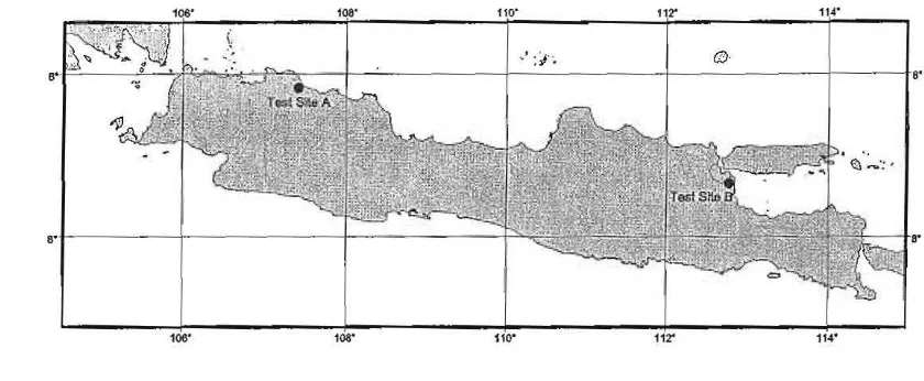
site was In West Java province, located on north coasrnLreglon. The site was previously studied on Its Importance on national food supply (Wlnoto et aI., 1996). Despite on its significance, vast conversion has been witnessed, in particular on its alteration to industrial uses (Firman, 1997). The second was located on the Brantas River delta which widely known as one of prime lands In East Java prevince. The site was under major threads, not only due to land use change (again to industrial expansion) (Damayanti, 2003) but also vulnerable to recent mud flooding after a failure In energy exploration (for details, see www.eastjavamud.net). Figure 1 shows both site locations.Kumpu/an Riset Ke/autan: Menuju Sumber Daya A/am Yang Lestari
Fig ure 1. Test sites
3. Data Processing
Decision tree (also known as classification or statistical tree) has been a popular approach for data mining or segmentation for remotely sensed imagery. Classification and Regression Tree (CART) presented by Sreiman et al. (1984) was used considerably for various problems, including agriculture (Waheed et aI., 2006) and forestry (Herold et ai., 2003).
In this paper, we evaluate a dassification tree analysis introduced by Loh and Shih (1997), then improved by Kim and Loh (2001) with unbiased multiway splits. -More enhanced versJon of this type by incorporating bivariate linear discriminant node models was presented by Kim and Loh (2003), however the last approach is not being discussed in this paper. A variant of decision tree analysis knows as QUEST (Quick, Unbiased, Efficient Statistical Trees) was evaluated in this research, in comparison with the maximum likelihood algorithm (MLA). Th,e model allows to cut down tree size, develops class prediction and builds up data visualization. Reduction of tree size can be accomplished by allowing the discriminant models share parts the data complexities. In addition, the models enhance estimation accurateness. The analysis allows obtaining better decision on classification problems.
4. Results and Discussion
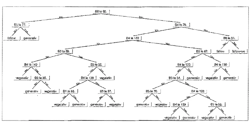
Employing selected training data, the QUEST algorithm automatically built a decision tree model for West Java site presented in Figure 2. As shown, the tree is fairly complex and makes use almost all available bands. Notation 6 represents corresponding Landsat band number, e.q. 62 denotes band 2 and so on, with exception on S6 which indicates band 7.
"
L
On the Decision Tree Analysis for CoastalAgriculture Monitonng
The model exploited band 7 of landsat as the starting point to separate bare soil (or dry fallow in this case) from vegetated and/or wet surface. At band 7, low digital numbers CONs) cover areas which were ready for planting (waterlogged) and already in growing sequence. After the separation, visible bands pl.ay role fallow and vegetative cover. At the end of branches, band 1 was used to discriminate vegetative and generative stages. Detail of alternative combination charactEristics for each class was presented in Table
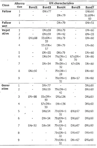
Table 1 shows all alternatives of classification results using DTA. There were two 。セ・イョ。エゥカ・ウ@ of combination for fallow class, one for wet fallow class, and nine alternatives for vegetative and generative classes as well. Apparently, only 3 bands were involved in generating alternatives for fallow, I.e. band 3, band 4 and band 7; while alternative combination of wet fallow was only Involving 2 band, I.e. band 4 and band 7. Segmentation of generative and vegetative stages mostly required band 7 and band 4, however some alternatives involved band 3, band 5 or band L
The DTA result showed that the most important band to differentiate the classes was band 7, which contributed in creation of all classes. The next important bands were band 4, tt;en band 3. Band 1 was involved only on four alternatives.
KumpuJan Riset Kefautan: Menuju Sumber Daya A/am Yang Lest;Jri
Figure 2. Decision tree of West Java dataset. See text for notations.
[image:7.612.150.559.85.284.2]On the Dedsfon Tree Analysis for Coasta!Agriculture Monitoring
Table L Alternative combination DN characteristics of DTA result of West Java Dataset
...
-Alterna
DN characteristics
Class
tlve
Bandi
Band3
Band4
BandS
Band7
Fallow
1 DN;e?? DN;e602
DN<79 51:$DN<60
Fallow
1 DN<79 DN<Slwet
..
_._
...Veget
1 DN2:59 DN2:79 DN<60atlve
2
DN2:59 DN<42 DN<353
DN2:88 55:$DN< DN2:79 DN<6059
4 5S:$DN< DN<79 DN<60
57
5
DN<S5 DN;,79 DN<606 DN2:54 ?9,;DN<1 6?,;DN< DN<60
32 70
? DN<S4 79"DN<l 67"DN DN<60 32
8
DN2:92 795DN<1 DN<6028
9 795DN<1 DN<6? DN<60
32
Gener
1 DN<77 DN2:60ative
2 DN259 79:$DN<1 DN26042
3 DN<88 55,;DN< DN2136 DN;e50
S9
4 57:5DN< DN<136 DN;e60
59
5
DN2:54 79:$DN<1 dnセVW@ DN2:60s
32
6 DN<S4 79:$DN<1 DN2:67 DN2:60
29
7 DN<92 DN<54 ?9:$DN<l DN2:67 DN2:60
32
8
79:$DN<1 DN2:67 DN2:6Q32
[image:8.612.185.511.115.608.2]Kumpufan Riset Kelautan: Menuju Sumber Daya AfarI'{ Yang Lestari
Tn classification procedure, we noticed similarity in accuracy between decision tree analysis using QUEST algorithm (Table 2) and the Maximum Likelihood algorithm (Table 3), Using the same training set on Subang district, West Java, performance of DTA and HLA was reasonably accurate, about 99,7%, No distinct performance on both algorithms was able to be detected, However, apparently the DTA could differentiate slightly better on generative and vegetaUve class mixture than the MLA,
Table 2, Accuracy assessment on West Java dataset using QUEST, The overall accuracy is 99,70%,
Class fallow Fallow-Wet Vegetative Generative
Fallow 99,91 0,00 0,00 0,10
Fallow,Wet 0.00 100,00 0,00 0,00
Vegetative 0.00 0,00 99,67 0,67
Generative 0,09 0,00 0.33 99,24
...
_
-Table 3, Accuracy assessment on West Java dataset using セャ。クゥュオュ@
likelihood, The overall accuracy is 99,70%,
Class Fallow Fallow-Wet Vegetative Generative
Fallow 100,00 0,00 0,00 0,00
Faiiow-Wet 0,00 100,00 0.00 0,00
Vegetative 0.00 0,00 99.45 0,86
Generative 0.09 0,00 0,55 99,14
On the Decision Troe Analysis for Coastal AgricultJJre Monitoring
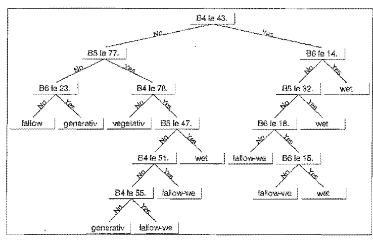
Figure 3, Decision セイ・・@ of East Java dataset
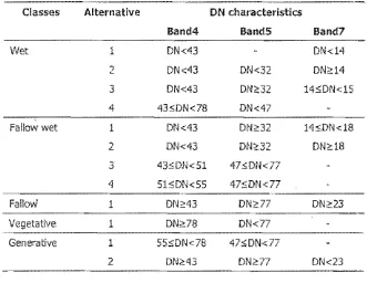
In this tree model, starting node was band 4 with a threshold of 43, This value discriminated wet regions (with DN less or equal than 43) from their surroundings, The regions were then separated into nodes using infra-red regions to retrieve purely-wet area and partly-wet (In our case, wet fallow class), This separation was reasonable since infra-red spectrum (espedally band 7) provides information on underlying soil. area was directly governed by band 4 and 5, which was showing distinct classes of vegetative and generative stages, Table 4 shows importance of band 4 in this model, similarly to band 5, Band 7 was used in some cases
if
similarity of characteristics on band 4 and band 5 were detected, Comparison of accuracy assessment between classification algorithms is presented in Table 5,;
[image:10.612.166.535.87.328.2]Ku{qpulan Riset Kelautatt' Menr..-:lu Sumber Daya A/am Yatlg Lested
Table 4. Alternative combination DN characteristics of DTA result of East Java Dataset
Classes Alternative ON characteristics
Band4
BandS
Band7
Wet 1 DN<43 DN<l4
2 DN<43 01'<32 onセQT@
3 DN<43 DN;:32 14:5DN<lS
4 43:50N<78 DN<47
Fallow wet 1 DN<43 DN2:32 14"ON<18
2 ON<43 01';:32 DN2:18
3
43:501'<51 47sDN<774 51:5DN<55 47sDN<77
Fallow 1 DN;::43 ON,,77 ON;::23
Vegetative 1 01';>:78 ON<77
Generative 1 55"DN<78 47sDN<77
2 01'2:43 DN,,77 DN<23
Table 5. Comparison of algorithms using East Java dataset
Class
QUESTMlC
Fallow 100.00 100.00
Fallow-wet 98.31 98.09
Wet
Vegetative
,
99.55
98.25
97.77
98.50
Generative 99.44 98.87
Overall accuracy 99.13 98.65
Apparently, DTA of East Java dataset were relatively more reasonable in line with deducted knowledge about band characteristics than of West Java dataset. Despite of its complexity In taking proper training regions, our understanding on the East Java case was coherent with common knowledge in spectrai sensitivity. It indicates that an autonomous model derived from
[image:11.612.177.508.135.391.2](Of'! the Dedslon Tree Analysis for Coastal Agriculture MorJitorfng
QUEST algorithm was reasonable and can be linked with common spectral response of surface covers,
5. Conclusion and Outlook
Monitoring agricultural fields have been a priority to support food security, As remote sensing technology becomes mature and readily available, exploitation of the data requires major breakthrough on data processing, To date, most users employed
a
remote sensing toolbox available on-the-shelf which eventually uses maxlmum likelihood approach,In this research, we discuss a comparison of a version of decision tree analyses (QUEST) with mostly-used maximum likelihood on two different agricultural sites, Although the difference was Insignincant, we showed that on both test Sites, QUEST conSistently outperformed maximum likelihood,
Mentioning the consistency, It is strongly suggested
that
further explorations on decision tree analysis should be conducted, The decision tree has been widely known for its simplicity, therefore is easily to be implemented, In near future, we would like to implement a Wider comparison study employing various approach of statisticaltr,ee,
including CRUISE or C-5. To avoid site bias,we
suggest an exploration on fairly difficult region with Significant class overlap.6.
AcknowledgementsWe would like to express our gratitude to the Head of Department of Soil Sciences and Land Resources of IPS for the support, The authors thank Prof, Brian lees and Dr. David Paull (Schoo of PEMS, UNSW at ADFA) for their support and AusAID (APS scholarship) for funding assistance,
7. RefereQce5
L. Srelman, J.H, Friedman,
RA
Olshen and C,J, Stone, 1984, Classification and reg,.ession trees. Chapman and Hall, New York,R, Damayanti, 2003, land use change in an area surrounding an industrial estate: a case study of Surabaya Industrial Estate Rungkut (SIER), Indonesia. Thesis, Curtin University of Technology, Australia,
Kampu/an Riset Kelautan: l1en:..;ju Sumber Daya Aiam Yang Lestad
H, Kim and W,-Y,
loll, 2003,
ClaSSification trees with bivariate linear discriminant node models, Journal of Computational and Graphical Stal'istk:s; 12: 512-530,H, Kim and W.-Y. Loh, 2001. Classification trees with unbiased multiway splits. Journal ofAmerican statistical Association, 96: 598-604,:
T,-5, Lim, W,-Y, Loh and Y.-S, Shih, 2000. A comparison of prediction accuracy, complexity and training time of thirty-three old and new classification algorithms. Machine Learning, 40: 203-228.
W,-Y. Loh and Y.-S. Shih, 1997. Split selection methods for classification trees. Statlstlca Sinica, 7: 815-840.
S.K. Maxwell, J.R. Nuckols, M.H. Ward and R.t4. Hoffer. 2004. An automated approach to mapping corn from landsat imagery. Computers and Electronics in Agriculture, 43: 43-54.
14.A. Raimadoya, B, Trisasongko and Nurwadjedi. 2007. Exploration of radar imageries for food security intelligence. Proceedings Second Indonesian Geospatlal Technology Exhibition. Jakarta, Indpnesia, 29 August - 1 September 2007,. [in Indonesian]
T. Waheed, R.B. Bonnell, S,O. Prasher and E. Paule!. 2.006. Heasuring performance in preCision agriculture: CART - a decision tree approach. Agricultural Water Management, 84: 173-185.
X. Wang,
Q,
Wang, F. ling, X. Shi, Y. Chen and X, Zhu, 2005. Envisat ASAR data for agriculture mapping in Zhangzhou, Fujian Province, China.Prc!re"dl!lgs 2005 Dragon
Symposium
Mid-TermResults,
Santorini,hCPA'P 27 June - 1 July 2005. ESA SP-611 (January 2006).
J, Winoto, M. Selari, S. Saefulhakim, D.A. Santosa, N.A. Achsani and D.R. Panuju. 1996. Agricultural land conversion to non agricultural uses: performance, institutional effect and coordination mechanism on land conversion controlling. Proreedlngs National Seminar of
National Land Agency, Jakarta, 28 !·1ay 1996. [in Indonesian]
X. Xiao, S. Boles,
J.
Uu, D. Zhuang, S. Frolking, C. U, W. Salas, B. イセッッイ・@ Ill. 2005. Mapping paddy rice agriculture In southern China usingmulti-temporal t40DIS Images.
Remote Sensing
ofEnvironment,
95:480-492.
On the Decision Tree Analysis lor Coastal AgrlC1Jlture Monitor/ng
BIOGRAPHY
Dyah Retno Panuju is a junior lecturer of Laboratory of Regional Development, Department of Soil Sciences and Land Resources, and a researcher of P4W, Bogar Agricultural University. Her research interest has been spatia-temporal modeling of land use and environmental problems. Email: !l.Jlll.nuiu@hotmaiLcom
Eman Rustiadl is a senior lecturer and the director on the same institutions. He received a master and a doctorate degree in regionai planning from Kyoto University, Japan. Previously, he was a principal Investigator for many research funded by national and international donors, such as RUT and Sumitomo. His research covers various aspects of regional analysis span from spatial analysis to institutional development. Email: [email protected]
Ita Carallta completed a master degree In soil science with speCialization in remote sensing and GIS analysis after conducting undergraduate study on statistlcs. She is now a senior researcher with National Institute of Aeronautics and Space (LAPAN) in Jakarta. She was a principal investigator for research on opticai and microwave remote senSing and Is currentiy inv,olved with Japanese ALOS research. Email: ltiLl;[email protected]
Ilambang Hendra Trisasangko is a researcher on remote sensing applications at P4W, Bogar Agricululral University. His researcli interest has been exploitation of SAR data on forest and agricultural landscapes. Recently, he is a student at The University of New South Wales at The Australian Defence Force Academy. Email: [email protected]