ISSN: 2339-076X, Volume 2, Number 1 (October 2014): 235-242
DOI:10.15243/jdmlm.2014.021.235
Research Article
Mitigation of land degradation at Juana Watershed, Central Java
I.B. Pramono*
Watershed Management Technology Center, Agency of Forestry Research and Development, Ministry of Forestry.
* corresponding author: [email protected]
Abstract:
Land degradation became more and more widespread, especially in areas with a dense population and dependence on agriculture is high enough. Land degradation can be approximated by the susceptibility of land to erosion. This study aims to identify existing land degradation in the Juana watershed, Central Java. The method used is the analysis of the typology of the watershed. This method is based on the interaction between landforms and land cover. The results showed that the degradation of land in the watershed very heavy scattered in the upstream areas in the territory of the Kudus and Pati regency. While severe land degradation are also scattered in Kudus, Pati, and Blora regency. Almost all of these degraded areas are used for dry land farming. By knowing the rate of spread of land degradation, the authority having jurisdiction in this district offices on issues related to land degradation can plan the actions necessary to resolve or mitigate land degradation in each region so that a major disaster will not happen or the impact can be minimized.Keywords:land degradation, typology, Juana watershed
Introduction
Widespread land degradation along with the growth of population incomes who depend on agriculture. An estimated 500 million people are subsistence farming in these marginal areas (Craswell et al. 1998). Higher population growth causes the land to more intensive processing that will eventually lead to problems of erosion, sedimentation and the formation of critical lands. Juana Watershed including one critical Watershed in Central Java. This watershed includes several districts in the northern part of Central Java. Treatment requires both the upstream-downstream integration, inter-sector and inter-district government. One of the problems in the watershed Juana is land degradation. In addition to causing declining land productivity, land degradation is also causing other environmental impacts such as flooding and drought.
The initial phase of a watershed management planning is the problem identification. The result of problem identification in a watershed can be used as one input for watershed planning by all stake holder in the watershed (Pramono et al. 2011). One of the problems encountered in the management of the watershed is land degradation.
Land degradation can be estimated by the identification of susceptibility of land to erosion. The vulnerability of this area can be seen from the interaction between landforms and land cover (Paimin et al., 2012). Landform mountains with closure crops would be vulnerable to erosion, contrary to the plain landform forest land cover will not be susceptible to erosion.
Mitigation of land degradation should be done to reduce severe the environmental impact. The land should be covered by permanent vegetation, because the vegetation can protect soil surface from splash and sheet erosion through three layer such as canopy, litter, and soil pores, therefore runoff can be maintained (Pereira, 1989 in Asdak, 1995). In fact most of the degraded land cannot be planted by only permanent trees because the farmers need cash crops for daily lives. This paper aims to mitigate land degradation in the watershed Juana using watershed typology analysis.
Materials and Method
and Jepara districts, Central Java Province. Materials used for this study were (1) The maps (hard copy and digital) scale 1: 50.000 - 1: 250,000, among others Indonesian Topographic maps, soil, geology, land use, RePPProT, (2). Landsat 2008, (3) Materials for printing maps and GIS data processing, (4) Blank survey field checks. Equipment used for this study were (1) Stationery, (2) GPS, meter, Abney level, (3) GIS Unit, and (4) Camera. Data analysis is directed
according to the typology diagram watershed. Vulnerability of land obtained from the interaction between landforms and land cover. Each landform and land cover were scored. Form of swamp land were given a score of 1, whereas mountainous land forms were scored 5. Forest land cover were given a score of 1, while the closure of dry land were given a score of 5. Score the interaction between landforms and land cover can be seen in Table 1.
Table 1. Scale Vulnerability / Sensitivity Against Land Degradation.
Landform* Land cover
Alluivial fan, and Lahar, Terrace (4)
1 2.5 3 3.5 4 4.5
Mountains and hills (5) 1 3 3.5 4 4.5 5
Results and Discussion
Biophysical Condition
Geographically Juana watershed in the position coordinates between 110 ° 49 '10 "- 111 ° 12' 57" East Longitude and between 6 ° 36 '48'' - 6 ° 59' 29'' South Latitude Juana watershed administratively includes five (5) districts namely Pati regency 97672.8 ha (74.91%), Kudus 28356.17 ha (21.75%), Blora 3411.96 ha (2.62%), Grobogan 941.71 ha (0.72 %), and the district of Jepara 8:59 ha (0.007%). The administration map of Juwana watershed is presented in Figure 1.
Slope steepness
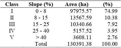
Slope steepness of Juana watershed is dominated by flat areas with a form region that has a slope of 0-8%. This includes ± 75% of the watershed area of Juana. Areas with gentle slopes (8-15%) cover ± 10.38% region, rather steep slope (15-25%) covers an area of 7.9%, a steep slope (25-40%) covers 3.9% of the territory and the rest with a steep slope (> 40%) covers2.76% wide area. It can be said that 13.36% of the watershed area Juana is on a rather steep slope conditions up to very steep. This field slope rate affects the speed
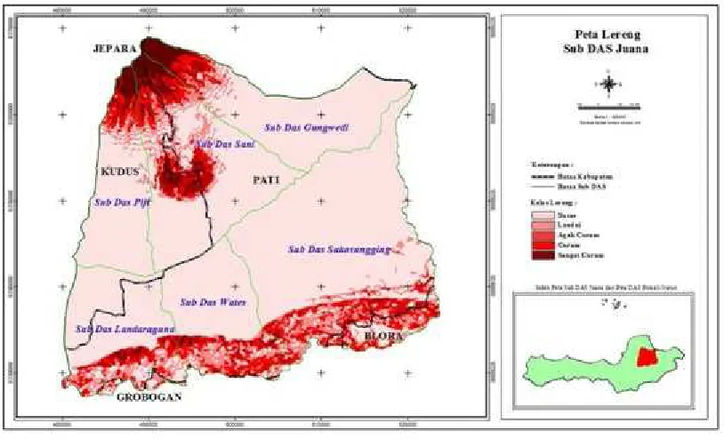
and erosive power of overland flow. In detail the condition of the slope basin Juana is presented in Table 1 and the distribution of slope in the watershed as shown in Figure 2.
Table 1. Slope class of Juana watershed
Class Slope (%) Area (ha) (%)
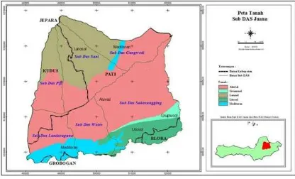
generally classified in the sub-group entisols with physiographic regions formed on flood plains. materials sediment carried by the river then deposited and accumulated in this area. Then followed by the type of clay texture latosol having
up to blocky and crumb structure covers an area of 22.41%. in more detail the area of each soil type in the basin Juana presented in Table 2 and Soil Map in the watershed can be seen in Figure 3.
Figure 1. Administration Map of Juwana Watershed
Table 2.The area of soil type in Juana watershed
Soil Type Area (ha) (%)
Aluvial 76097.32 58.25
Grumusol 2522.63 1.93
Latosol 29276.89 22.41
Litosol 11595.45 8.88
Mediteran 11146.11 8.53
Total 130391.38 100.00
Source: BPDAS Pemali Jratun, 2006.
Geology
Based on the analysis of geological map, the type of rock in the basin Juana include alluvium, rock containing leusit, Miocene limestone facies,
Miocene sedimentary facies, sedimentary facies Pliocene, Pleistocene volcanic facies and reservoir / lake. The extent of each type of rock Juana basin is presented in Table 3 whereas Geological Map of the watershed as shown in Figure 4.
Rainfall
The rainfall data obtained from observed existing stations in Juana watershed. The rainfall in this region ranges from 823 mm / year up to 3,341 mm / year with an average of 2.522 mm / yr, the number of rainy days ranged between 87 days / year to 146 days / year. The highest rainfall usually occurs between October to April.
Figure 3. Soil Map of Juana Watershed
Table 3. Rock Types of Juana Watershed
Rock Types Area (ha) (%)
Aluvium 67194.41 51.44
Rock containing leusit 36034.18 27.58
Miocene limestone facies 11850.96 9.07
Mioses sedimentary facies 6409.32 4.91
Pliocene sedimentary facies 6324.41 4.84
Plistocen volcanic facies 2656.48 2.03
Total 130391.38 100.00
Figure 4. Geological Map of Juana Watershed
Mitigation of Degraded Land at Juana Watershed
Land system
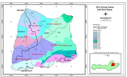
The division of the land system describes the shape, description of the parent material, rock type, soil type, slope, annual rainfall, wet months and dry months. Under the system of land, divided into 10 watershed Attack land system are: KHY (Kahayan), MKS (Napier), BRN (Bogoran), LTG (Loud), KJP (Kajapah), HBU (Hiliboru), KLG (Necklace), BMS (Masung hill), BOM (Bombong), BRI (Bonto Sapiri), and WDK (Reservoir). Land in the watershed system deployment Attack can be seen in Figure 5.
Land Cover
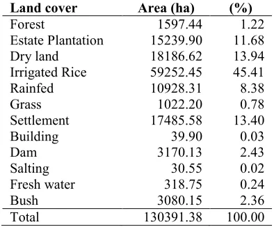
Types of land cover in the watershed varies from Paddy Field, Rainfed rice fields, dry land, Estate Plantations, Forests, Settlements, Salting, grassland, scrub and others. The most extensive land cover in the watershed is use for irrigated rice field which covers 45.41% of the territory,
then the use of land to dry land covers an area of 13.94%. land use such as forests covering an area of 1.22%. in more detail the area of each land use in the watershed presented in Table 5 and the distribution of the land cover as shown in Figure 6
Table 5. Land Cover in Juana Watershed
Land cover Area (ha) (%)
Forest 1597.44 1.22
Estate Plantation 15239.90 11.68
Dry land 18186.62 13.94
Irrigated Rice 59252.45 45.41
Rainfed 10928.31 8.38
Grass 1022.20 0.78
Settlement 17485.58 13.40
Building 39.90 0.03
Dam 3170.13 2.43
Salting 30.55 0.02
Fresh water 318.75 0.24
Bush 3080.15 2.36
Total 130391.38 100.00
Figure 5. Land System Map of Juana Watershed
Figure 6. Land cover map of Juana watershed
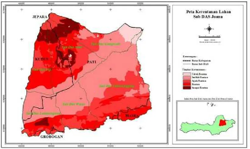
Land Susceptibility
One of the factors that cause degradation of natural resources in the Juana watershed is a land utility. Optimal land productivity and sustainable land use will be achieved when adapted to the ability of carrying capacity. Most of the degraded land in Juana watershed occurred in the upper part where the slope is steep (25 – 40 %) and the land
Figure 7. Land Susceptibility Map of Juana Watershed
Based on Figure 7, the local government of Kudus and Pati district should pay attention on their heavy degraded land. They have to collaborate to solve the problem because the heavy degraded areas are located in their administrative border. One of alternative solution is introducing agroforestry system where the land is cultivated mixing between tree and cash crops. Alwi et al. (2011) mentioned that plantation of cocoa, orange, pepper, bananas, and maize can reduce soil erosion and surface runoff in South East Sulawesi. The farmer and local government should determine the most suitable tree and cash crops in their land. Some soil conservation measure should be applied in certain areas where slope steepness is high. Although district of Blora and Grobogan have small contribution area in Juana watershed, they should rehabilitate their degraded land because the impact will influence in lower part of the watershed.
Conclusions and Recommendations
1. Land degradation in the watershed Juana is heavily spread into the upstream area of the Kudus and Pati Districts. Almost all of these degraded areas are used for dry land farming.
2. The impact of degraded land is not only on the land itself, but is also on the lower part of the watershed. Therefore, watershed analysis
unit is the most appropriate technique for the mitigation of land degradation.
3. Handling of degraded lands can be started from a very vulnerable land in each district. 4. By knowing the rate of spread of land
degradation is the authority having jurisdiction in this district offices on issues related to land degradation can quickly plan the actions necessary to resolve or mitigate land degradation in each region so that no greater disaster will occur.
References
Asdak, C. 1995. Hydrology and Watershed Management. Gadjah Mada University Press, Yogyakarta (in Indonesian).
Alwi, L.O., Sinukaban, N., Solahudin, S. and Pawitan, H. 2011. A study of the impacts of landuse dymanics on erosion and hydrolical conditions of Wangu watershed. Jurnal Hidrolitan 2(2): 74-86. (in Indonesian).
BP DAS Pemali Jratun. 2006. Characteristics of Juwana watershed. (in Indonesian).
Craswell, E., Bechstedt, H.D. and R. Lefroy, R. 1998. Asia’s ecologycal crisis. International Board for Soil Research and Management (IBSRM). Bangkok.www.soilusda.gov/use/worldsoils/Landde g/199808news.html.