TARU is one of )ndia s most influential consulting firms. Working with government, multilateral and bilateral Development Partner, corporate and civil society clients, we have shaped development policy, practice and debate in )ndia since . TARU s work includes Country Strategy development for )ndia s largest Development Partners; design and management of reform initiatives in key sectors; world-class disaster risk assessment and mitigation planning; and, assessments
of some of the world s largest public programmes.
Please use the following reference for this report:
)ndore City Resilience Strategy Team : Final Report on city resilience strategy, )ndore, eds. Bhat, G.K., Kulshreshtha, V.P., Bhonde, U.A., Rajasekar, U., Karanth, A.K., Burvey, M.K., Total Page No .
© Copyright,
TARU Leading Edge Pvt. Ltd.
This publication is made possible by the support of Asian Cities Climate Change Resilience Network ACCCRN . The findings, interpretations and conclusions expressed in this paper are that of the authors alone.
Any part of this publication may be cited, copied, translated in to other languages or adapted to meet local needs without prior permission from TARU provided that the source is cited clearly.
First Edition:
May
Published by:
TARU Leading Edge Pvt. Ltd.
Design & Layout: Tejas Patel
MESSAGE
This is a moment of great pleasure for )ndore city as it takes one more step forward in the fight against climate change related risks. Being a global challenge, climate change has started hitting the city for a long time and there was a need to study the relation of possible Climate Change and their impacts on different developmental aspects of the city.
As per an estimates, by more than percent of the world's population will live in urban areas, with most of the world s population growth over the next twenty-five years will be absorbed by cities and towns in low and middle income countries. Today, nearly one billion people live in slums, and in the absence of significant intervention that number is set to double in the next two decades.
Remarkably, )ndore is also a city that needs sincere efforts in order to deal with the growing threat of climate change related risks. As the study under ACCCRN reveals, )ndore is among the vulnerable cities of )ndia and there is an urgent need for interdisciplinary interventions on several fronts. The present document is an example of the city s readiness to bring the issue among the planners and managers. This effort signifies the spirit of the city to fight the climate change allied possible risks in the most efficient way for the city.
) believe the effort in the form of this City Resilience Strategy CRS document will help the planners, policymakers and the managers to efficiently deal the challenges ahead and ) wish them all the success.
FOREWORD
)t is great pleasure to introduce the City Resilience Strategy CRS for the city of )ndore. This is a result of long and consistent efforts of many institutions and individuals and ) congratulate them.
)n past few decades, rapid growth of major cities in )ndia has taken place. The process of urbanization has created new opportunities. At the same time, un -envisaged problems had also emerged for both the planners and citizens due to rapid urbanization. The growth in population, increasing numbers of people migrating towards cities, increase in vehicle numbers and allied factors have created serious challenges for the city planners and managers.
Cities, being the major drivers of the economic and political activities in )ndia are becoming vulnerable towards the possible threats of climate change. Most of the cities have started to experience climate variability related issues. This is a burning reality of our times and every major city needs to tackle the issue in the best possible way. The processes responsible for the climate change on the global scales are not reversible and the damage that has been occurred will need long-term efforts to establish an equilibrium again. Long-term projections of temperature rise and changes in the patterns of distribution of rainfall across the season along with the other characteristics of urbanization may lead to new problems. For example, on health front the increasing average temperature will lead to stretched summers. As a result of that, the risk for vector borne diseases may increase within the city and its surrounding areas. These factor coupled with the commonly seen water logging, especially during monsoons, may intensify the water born diseases in urban areas. Similar threats/risks have been forecasted on various sectors like water resources & their management , solid waste management, health surveillance and transportation.
Due to these vary facts and also the possible climate change related variability knocking the doors; )ndore Municipal Corporation )MC along with the City Advisory Committee CAC has facilitated and guided the vulnerability assessment exercise in )ndore city over the past three years. The assessment was carried out by TARU under the Asian Cities Climate Change Resilience Network ACCCRN project. Under ACCCRN, a CAC was established to overview the studies on possible impacts of climate change, and to recommend strategies that would create a higher level of resilience for its citizens. )t is a matter of pride for the city that the CAC incorporates the views, wisdom and commitment of members of all sections of urban life, academia, industry, trade, local government and civil society.
)n the line of similar efforts the CAC has initiated the process of i assessment of the likely impacts of climate change on the socio- economic life of )ndore; ii identifying future challenges and iii initiating the formulation of viable and thoughtful strategies to address the same. The process essentially involved the analysis of some of the critical sectors, such as water, energy, health & environment, transportation, green buildings. More significantly, perhaps for the first time, an assessment was made on the vulnerability of different sections of the population to the changing weather patterns that may result in, increased precipitation, Waterlogging, changes in disease patterns, increasing energy demand etc. The work under the ACCCRN initiative in )ndore over the past three years establishes the nexus between urban systems, poverty related challenges, underlying city vulnerabilities and the overriding phenomena of climate change and the risks posed thereby. Vulnerability of the city, if not recognized and addressed, will only exacerbate with accelerated incidence of extreme weather events.
Therefore, the process of formulation of a city resilience strategy was initiated in )ndore during - . Realizing the cross-sectoral nature of the impacts, the CAC adopted an interactive and holistic approach entailing engagement with a wide array of stakeholders through Risk to Resilience R R workshops held during the ACCCRN programme. ) appreciate the concerns shown towards the future climate change variability are addressed timely in the form of City Resilience Strategy developed under the Phase )) of ACCCRN. ) also take an opportunity to acknowledge the efforts of the municipal corporation officials, various government departments, National )nstitute-)ndustry Forum For Energy, School of environment & Energy Studies, DAVV, )ndore, Mehta & Associates, TARU & several local organisations and individuals Mr. Mukesh Chouhan & team and Professor T. A. Sinhorwala & Team in contributing in towards the climate resilience efforts.
The City Resilience Strategy CRS is an attempt to assess the scale of vulnerability on key sectors, the risks and challenges likely to be faced by the city of )ndore due to possible climate change impacts, the likely impacts on crucial sectors and the kind of adaptation and interventions which can be taken to address the same. The CRS is the result of consistent and sincere efforts by a many enlightened and committed citizenry and crucial stakeholders of )ndore. )t is gratifying to note that all stakeholders actively as well as passionately contributed to the process to ensure that the document becomes a live and vibrant strategy which is owned and acted upon by all through a convergence of approaches and action. The CRS highlights innovative methods such as GEOPSY and scenario exercises which can also serve as effective urban planning tools in future for cities on the move.
) hope this document will serve as an important guideline in the direction of actions in dealing with the possible Climate Change related uncertainties particularly for the )ndore city. The efforts put in the sector studies and subsequently preparing this resilience strategy will not only help various organizations, institutions and individuals but also inspire one and every citizens who have been working for the similar cause.
MESSAGE
The Rockefeller Foundation has been extremely proud to partner with the city of )ndore under its Asian Cities Climate Change Resilience Network ACCCRN initiative. As an important urban centre in the heart of the country, the manner in which )ndore responds to the challenge of climate change can serve as a mod-el for many other places. Though climate change is a global problem, actions need to be taken locally to hmod-elp communities prepare for and weather climate -related impacts. The efforts of the city to date are indeed impressive, but much more remains to be done.
The stakes for cities such as )ndore are particularly high given its importance as a growing economic centre, and the challenges it faces with regard to water management, heat stress and other climate-related issues. Cities now house more than half of the global population, including hundreds of millions of poor and marginalized households, making it essential that steps are taken to increase their resilience to withstand the shocks and stresses spurred by climate change. )n this context, the Rockefeller Foundation is delighted to see the launch of the )ndore city climate change resilience strategy. This strategy reflects a tremendous amount of leadership, effort and dedication shown on the part of a wide range of institutions and individuals within it, from government, business, academia, technical centres and civil society. We look forward to seeing the city continue to serve as a globally recognized leader in strengthening resilience to climate change.
Mr. Ashwin Dayal Managing Director, Asia Office
ACKNOWLEDGMENT
On behalf of the )ndore City Advisory Committee CAC , ) am happy to engrave few words on this City Resilience Strategy CRS document. This document is a result of three years of sincere efforts made by )ndore Municipal Corporation )MC , State government departments, academic institutes, NGO s, professional bodies and many individuals. )ndore city is fast growing city and will certainly be affected by impacts due to possible climate changes. The impacts may vary in their scales across various sectors water, health, sanitation, and solid waste disposal, infrastructure ; as all sectors are interrelated. The efforts during the implementation of Phase )) of ACCCRN programme remained very much crucial in identifying the sectors vulnerable towards the impacts of anticipated climate changes in the region. The exhaustive studies undertaken to assess the risks and vulnerabilities in sectors, engagements of various academics and private institutes, NGO s and also time to time meeting of these sectors during CAC meetings including the Risk to Resilience R R workshops in the city; provided valuable inputs towards finalizing the short, mid and long terms interventions. This will be required for adapting to the possible threats/impacts of the climate change by the city.
The work carried out through ACCCRN programme, with the sincere and dedicated efforts, is just the beginning towards making )ndore city more prepared for future climate variability and change.
) am extremely happy to pen down here that the city of the )ndore has initiated the process to deal with possible threats related to the climate change impacts which are currently gaining global attention. The document in your hand has been designed by using pictorial representation to make it more interactive. At the same time the various studies undertaken in the past are presented in very lucid manner in the present CRS document. This document will not only help technocrats but will also help common man to understand the impacts of climate change on the life of an )ndorian.
) congratulate one and all associated in bringing out this very useful City Resilience Strategy document.
Authors:
Mr. Anup Karanth Mr. Gopalkrishna Bhat
Mr. Lalit Dashora Mr. Manish Kumar Singh
Mr. Maulik Tanti Ms. Megha Burvey
Mr. Rajeev )ssar Mr. Sanjay Jothe Mr. Tejas Patel Dr. Uday Bhonde Dr. Umameshwaran Rajasekar
Contributors:
Ms. Roma Upadhyay Ms. Bhamini Patel
Mr. Vipul Parmar Mr. (ardik Prajapati
The Rockefeller Foundation Team:
Dr. Christina Rumbaitis del Rio Ms. Anna Brown Mr. Ashwin Dayal
Mr. Bob Buckley
)SET Team:
Dr. Marcus Moench Dr. Sarah Opitz-Stapleton
Mr. Shashikant Chopde Mr. Dilip Singh
AAS Team:
)ndore City Resilience Strategy
The th century has been a period of greatest warming in at least a thousand years. The )PCC Working Group found evidence that recent regional climate changes have already affected many physical, biological and in human systems. Water, energy and material consumptions has increased due to population increase & rapid urbanization. This has significantly altered Land Use & Land Cover LULC . Apart from natural changes in climate, drivers such as urbanization and pollution influence climate systems directly and indirectly. Ability to manage climate risks and other hazard risks depends on a number of critical factors including city s baseline infrastructure. Several attempts are underway to minimize the effects of climate change on priority sectors and vulnerable section of the society through building adaptation mechanisms.
)ndore is the most prominent city within the state of Madhya Pradesh. The issue of climate change is cross-cutting, it has a potential to affect a numbers of sectors
augmenting the growth of the city. Risk and vulnerability assessment was conducted for the city in consultation with )ndore City Advisory Committee CAC , )ndore Municipal Corporation )MC , academic institutions, private sectors and community. Sector studies were undertaken to determine the degree to which existing systems can adjust in response to, or in anticipation of, changed climatic conditions. The assessment results supported in framing an integrated resilience approach for the city of )ndore to deal with climate variability and climate change.
City Resilience Strategy CRS for )ndore has been informed on the basis of the assessment studies & aims to reduce the impacts of climate change by identifying sectors, communities most vulnerable to the climate variability & climate change risks and by suggesting resilience measures.
The aim of City Resilience Strategy CRS Document
This document is prepared with the aim of providing a framework for development of climate resilience strategy for the city of )ndore. )t has been developed based on interaction with city stakeholders, sector studies conducted to understand different dimensions of current situation, information from secondary literature, and through conduct of risk to resilience workshop.
CRS, is aimed at city managers and people at large. This document is based on the current situation and has a scope for updation to reflect emerging trends over time. The resilience strategies will therefore evolve over time with better understanding of climate change phenomena as well as emerging city level issues.
There are four sections in this document:
. Variability & Change : Dynamic factors that would affect the city . Possible )mpacts: Understood based on the infrastructure of the city
General
ACCCRN Asian Cities Climate Change Resilience Network
ADB Asian Development Bank
CAC City Advisory Committee
CBO Community Based Organization
CDP City Development plan
CEPRD Centre for Environmental Protection and Research
CRS Climate Resilience Strategy
DF)D Department For )nternational Development
DPR Detailed Project Reports
)CDS )ntegrated Child Development Services
)DA )ndore Development Authority
)DP )ndore Development Plan
)MC )ndore Municipal Corporation
JNNURM Jawaharlal Nehru National Urban Renewal Mission
MPEB Madhya Pradesh Electricity Board
MPPKVVCL Madhya Pradesh Paschim Kshetra Vidyut Vitaran Company Limited
MPUSP Madhya Pradesh Urban Services for the Poor
NGO Non Government Organization
N)PFP National )nstitute of Public Finance and Policy
NREGS National Rural Employment Guarantee Scheme
NVBDCP National vector Borne Disease Control Programme
PEARL Peer Experiences and Reflective Learning
P)P Priority )mplementation Projects
RAY Rajiv Awas Yojana
SJSRY Swarna Jayanti Shahari Rozgar Yojana
SRES Special Report on Emission Scenarios
STEP Support to Training & Employment Programme for Women
SWM Solid Waste Management
TCP Town and Country planning
ULB Urban Local Bodya
Technical
CC Climate Change
CGCM Coupled Global Climate Model
CNRM Centre National De Researches Meteorologiques
CSAG Climate System Analysis Group
DEM Digital Elevation Model
CVCC Climate Variability and Climate Change
DSV) Drainage and sewerage vulnerability )ndex
EC) Education Capacity )ndex
EPRE The instances of extreme point rainfall events
GCM Global Climate Model
G)S Geographic )nformation System
)PCC )ntergovernmental Panel on Climate Change
)S) )ncome Stability )ndex
LPCD Liters per capita per day
LVA Loan and insurance vulnerability )ndex
MLD Million Litres Per Day
MP) Max Planck )nstitute
MSL Mean Sea Level
PC) Park Cool )sland
PREC)S Providing REgional Climates for )mpacts Studies
RCM Regional Climate Model
SC) Social Capacity )ndex
SEC Socio Economic Class
SLR Sea level Rise
SPT Sewage Treatment plant
SRTM Shuttle Radar Topographic Mission
U() Urban (eat )sland
UFW Unaccounted-for-Water
WS) Water Scarcity )ndex
Variability & Change
Possible
)mpacts Evaluation & Assessment
Prioritized Strategies
Urbanization
Poverty / )nformal Settlements
Climate Conditions
Physical / Environmental
Social
Economic
Vulnerability Assessment
Capacity Assessment
Medium and Long term
Strategies
Approach to resilience
1
2
3
4
VAR)AB)L)TY AND C(ANGE
Urbanization
Poverty /
)nformal
Settlements
Climate
Conditions
Population
Living
Environment
Temperature
)ndustrial &
Economic
Growth
Livelihood
Earning
Precipitation
Land Use &
Land Change
LULC /
Environmental
Transition
Lifestyle
. Growth and Present Population
The population of the city increased from thousand in the year to lacs in . The city s population density ranges from persons/ha within the peripheral areas to as high as , persons per ha in the core of the city. On an average, the decadal growth rate has been around % which is higher than the national growth rate of %.
Migration is increasingly playing an important role in the population growth of the city. Being the only major city in the Western Madhya Pradesh, )ndore serves as educational, medical and trade hub; catering to a large floating population. With rapid urbanization, a significant section of this floating population may become city residents. As per the census of )ndia , provisional population of )ndore is , , . )t is , , by including the urban agglomeration.
. Future Projections
Future population projections have been attempted by )MC with various methods. The projections by geometric progression method indicate the population of )ndore to be around millions lacs by the year )MC .
Urbanization Poverty Climate Conditions
Population | )ndustrial & Economic Growth | LULC/Environmental
.
Growth and Present Population
.
Future Projections
Population
Source: Census of )ndia & )MC
Source: Census of )ndia,
. City Growth
The )ndore city which derives its name from )ndreshwar temple was initially known as )ndur/ )ndrapuri is located on the western part of Malwa drained by two rivers namely Khan & Saraswati. The growth of )ndore can be broadly placed in three distinct stages through history and the present stage is year old.
Pre– (olkar Period
)n year , Maratha king Bajirao Peshwa, handed over his kingdom to Malhar Rao, who ruled )ndore between - . During that time the total area . parganas. This area was
developed cantonment while later it developed into commercial city. The region emerged as an important military camp, owing to its location.
The (olkar Period
Establishment of (olkars capital at )ndore provided new forces for development of the city. )n (. V. Lancaster was invited, by the local body to advice on expansion of the city and improvement in the sanitary conditions of the residential areas. )n Sir Pattrick Geddes was invited, by Maharaja Tukoji Rao (olkar to advise the Government and local body to advice in respect of expansion and improvement of the city. (e prepared drainage and water supply schemes, industrial development schemes, suburban development, housing schemes and landscaping etc. for city.
The Post– )ndependent Period
)ndore )mprovement Trust )ndore Municipal Corporation )ndore Development Authority
Growing )ndore
Urbanization Poverty Climate Conditions
Population | LULC | )ndustrial & Economic Growth
.
City Growth
. Land Use Pattern & Change
Rapid spread and densification of the )ndore city has occurred over the period of time. Patterns of land use land cover change of the past four decades indicate growth being guided by the socio-economic processes which include population growth,
economic development, trade, intellectual capital, location advantage and migration.
As per the real estate planners, about , additional houses are required annually to meet the growing housing demands of the city. This intensification of land-use can
significantly and strongly magnify the effects of extreme climate events change in water use, micro-climate, urban heat
and energy balance etc. . Further, climate change scenarios and urbanization trend indicate the possibility of competing demands rising from upstream irrigation, energy generation and urban users.
.
City Growth
.
Land Use Pattern & Changes
Land Use
and
Land Cover
Change
Urbanization Poverty Climate Conditions
Population | LULC | )ndustrial & Economic Growth
Source: Google Earth )mage; Directorate of Town and Country Planning, Madhya Pradesh
)MC Limit
Planning Area
Yashwant Sagar
. Present )ndustrial Base
)ndore is essentially a trading center, and due to its strategic location serves as a hub of trade and commerce for the entire west part of )ndia. While there was presence of quite a few industries in the area, textile industry for a long time remained the central industry of the city. Multinational and national companies have chosen to set up their industries here, solely because of the availability of suitable infrastructure.
There are two main industrial areas outside the Municipal limits. Pithampur is about km in the south popularly known as Detroit of )ndia . The )ndore SEZ is established here. Other is in Dewas, northeast part of the city. There are about large and small & medium scale units in these estates and has considerable impact on the city s economy. These industries are capital intensive and high-tech.
. Expected Growth
As happening in other cities of this country, )ndore has also observed decline in the traditional industries and has witnessed restructuring of the economy. There are three main industrial areas within the city – Sanwer Road, Polo Grounds and Udyog Nagar with , , and small and medium scale units respectively.
Trade & commerce, financial sector & new high tech companies have replaced the traditional industries in )ndore. The dominant sectors are engineering, pharmaceuticals, fabrication and food processing. )ndore has trade spread across cotton textiles, chemicals, machinery, iron and steel, food and edible oil, confectionery, paper and straw board, RCC pipes and poles, machine tools and accessories, electrical machinery and appliances, electronic goods, pharmaceuticals, snacks and educational services. Pharmaceutical, Textile, Food Processing, )nformation Technology, Apparel Park, Gem and Jewelry Park, Software Technology Park and (erbal Park. )ndore registered work force participation rate of % and during census, with . % working population employed in tertiary sector and . % Population employed in secondary sector. Projected population of )ndore metropolitan area is estimated to be . million by .
Present )ndustrial Distribution
Urbanization Poverty Climate Conditions
1.
Living Environment & Differential impacts on poor
Around % of the city s population currently live in slums. Significant proportions of slums in )ndore are located along the stream and are prone to floods. They are also vulnerable to water logging and vector-borne diseases due to their proximity
to flood plains and water logged areas. The temperature increase is also likely to cause differentially higher impacts on poor due to overcrowded settlements, low ventilation and poor vegetation cover. Since most poor cannot afford space cooling devices beyond fans, nor the increasing costs of electricity, they are likely to be impacted differentially.
Map showing distances of slum locations
from drainages in Indore
.
Living Environment
.
Livelihood Earning
.
Life Style Social Status, Aspiration
Poverty
Slums along drainage
Urbanization Poverty Climate Conditions
Living | Livelihood | Life Style
Source: )MC; TARU Analysis, Source: TARU Field Study,
. Livelihood Earning
)ndore city emerged from being a trading centre to textile manufacturing city to a hub for automotives, light engineering, food and pharmaceuticals industries. While most of the large industries are located outside the city limits, )ndore provides a variety of services to support these industries, in addition to large hinterland. (ousehold food industry also contributes significantly to the economy of the city.
)ndore is the business and trading capital of the state. Located at the crossroads of western and central )ndia, )ndore has relatively good connectivity and has been the hub of trade and commerce not only for the state but also for western )ndia. The city hoods a dominant position and is a vibrant center for trade and commerce.
The population living in slums of the city can be broadly classified by occupation type as: Unskilled/Vendor/(awker Semi Skilled, Skilled, Government Service Class ))) & )V , Skilled Professionals, Self Employed/Business & Pension/Others.
.
Living Environment
.
Livelihood Earning
.
Life Style Social Status, Aspiration
Poverty
Urbanization Poverty Climate Conditions
(istory of Slum )mprovement Programmes
Since early s, there is a history of externally aided projects in )ndore for slums up-gradation
including the award winning )ndore (abitat )mprovement Project )()P funded by the Overseas Development Agency. )()P, executed by the )ndore Development Authority, was a comprehensive project dealing with construction of roads, extension of piped sewerage, construction of sewage treatment plants, and slum up gradation. Amid other works carried out under the project, the )ndore Slum Networking project won the Aga Khan Award for Architecture. Under various donor funded programmes, improvement of slum areas are being attempted. But the outcomes of such measures do not last beyond the project periods. The recent of donor funded programme, MPUSP, has overcome many of these issues, but the issue of solid wastes still needs attention to provide sustainable solutions.
Place of Origin : Migrants
Urbanization Poverty Climate Conditions
Living | Livelihood | Life Style
(ousing for Urban poor:
The eight year project which was implemented in slums demonstrated the potential of improvement of slums, rather than their clearance.. Under VAMBAY and JNNURM schemes about , housing units were constructed for urban poor and , units are being built. There are , more units proposed.
Although the city population doubled from 1971 to 1991, the slum population almost quadrupled over the same peri-od. In 1991, the population of the city was 1.25 million out of which slum dwellers accounted for 0.35 million
Source: Presentation by Sh. D.L.Goyal, Chief City Planner, IDA ,2009
Source: TARU Analysis,
1% 1%
75% 4%
2% 2%
5%
10%
Bihar Gujarat Madhya Pradesh
Maharashtra Punjab Rajasthan
Uttar Pradesh Others
.
Living Environment
.
Livelihood Earning
. Observed Climate
)ndore is located on the drought prone Malwa plateau. )ndore was known for salubrious climate with night temperatures less than C and day temperatures reaching around oC in summers. The winter temperatures at present go as low as C. The long term average annual rainfall is about mm, with variation within the years. The monsoon rainfall account for about % of the annual rainfall.`
. Temperature Change Prognosis
Result from the climate change models indicate that the monthly notable average minimum temperature in )ndore may increase by about C by s to about - C by s.
The Urban (eat )sland U() effects may add another - C
over and above these figures.
Most of the models indicate that the maximum increase is expected during winters. This may extend viability period of some of the disease vectors well into winters. The March to September period may require space cooling devices working through the day and night, considering the addition from U() effects. The maximum temperatures on some summer days may reach close to C, which impact people who maybe travelling for work. This increased temperature may increase the consumption of energy for cooling.
Observed and Future mean monthly temperature ranges:
-Urbanization Poverty Climate Conditions
Temperature | Precipitation
.
Observed Climate
.
Temperature Change
Prognosis
Temperature
Source: TARU analysis, ; G(CN 9 and CSAG,
Urban (eat )slands Effect
. Precipitation Change Prognosis
Rainfall scenarios for )ndore city show higher diversity. An increase in annual rainfall of about mm is predicted by A B scenario of PREC)S regional model for s, while an increase of about - mm is predicted by CGCM for
s while CNRM and MP) models do not indicate much change. The A and B scenarios under PREC)S predict an increase of about and mm in the annual total rainfall. There are a number of low lying areas across the city and therefore excess rainfall/intense precipitation will increase short term flood risks. Water logging and associated health risks may be of great concern. The city severely lacks sewerage infrastructure. The rainfall prediction is less certain than temperature changes, especially considering the terrain of )ndore city.
. Data Sources:
Global Climate Model GCM results were procured from Climate System Analysis Group CSAG and downscaled Regional Climate Model RCM results were procured from )ndia )nstitute of Tropical Meteorology ))TM , pune and were analyzed for )ndore city by TARU.
Future mean rainfall ranges:
-Urbanization Poverty Climate Conditions
Temperature | Precipitation
.
Precipitation Change
Prognosis
.
Data Sources
Precipitation
POSS)BLE )MPACTS
Physical /
Environmental
Social
Economic
Water: Water supply/
Sanitation / Water
Logging
Public (ealth
Energy
Land use and Planning
Social Cohesion
Solid Waste
Management
)nstitutional
Domestic Life style /
)ndustry
. Water Supply Sources:
)ndore Municipal Corporation manages the water requirements of city. The water need of the city is catered from multiple sources such as Narmada river, local reservoirs, ground water and private water suppliers tankers . The two groups Surface and Sub-surface has
following shares in fulfilling the water requirement of the city.
a. Surface Water: About % of )ndore s water supply comes from surface water. The Narmada Water Supply Scheme contributes to % , remaining is from Yeshwant Sagar Reservoir and the Bilaoli Tank.
b. Sub surfacewater: Tube wells as a public water supply source constitutes to about % of the total water supply. There are also more than , private tube wells & precise information regarding these tube wells is currently unavailable.
. Present Need Vs Supply:
Out of the MLD of water supply to the city, the ground water is estimated to provide around MLD. The water security study ACCCRN Phase )), reports illegal water connections in the range of , to , accounting to - % loss. Failure or repair of Narmada supply is
witnessed occasionally. The local sources reservoirs have silted up and have lost nearly % of their capacity. Based on the projections form the past growth rate it is expected that the population will increase to about million by . )ndustrial demand is expected to double from MLD to MLD by . After deducting the current supply, a gap of MLD is expected by . Total net requirement is expected to reach MLD by . Narmada piped supply is expected to provide MLD by and an additional MLD by . Based on climate change and urban growth scenarios, the study indicates possibility of competing demands rising from upstream irrigation and urban users.
Narmada Water Supply NWS Scheme:
Today the most important source of water for the city of )ndore is the Narmada Water Supply Project which involves pumping water from a distance of kms. away from Narmada River, and supplied to the city by pipelines. Despite the long distance and costly supply of the water to the )ndore; the per capita water availability remains still under the prescribed standards of CP(EEO Central Public (ealth & Environmental Engineering Organization . The total water supply to )ndore is MLD including the third phase of Narmada project. The water is supplied on every alternative day in the city for maximum of two hours.
.
Supply Sources
.
Present Need Vs Supply
.
Possible impacts due to urbanization, poverty, Climate Change
.
Projected need vs projected supply
Water
Supply
Physical / Environmental Social Economic
Water | LULC | Solid Waste Management | Transport
-The average requirement of the water in the )ndore city is presented in following diagrams. First represents the requirements of slums of upper Socio Economic Classes SEC of the city.
. Possible )mpacts
The important issues which are likely to adversely affect the water requirements of the )ndore city will be rapid urbanization, changing the land use land cover of the city, increasing migration floating population in search of education, employment. With water crisis already set in the city and further impacts of climate variability; indicate a bleak water security in future. This demands to reverse the accelerated depletion of existing water sources of the city of )ndore and also to work towards strengthening the water supply in )ndore. Water supply will remain as the critical service sector for )ndore.
a )mpacts of Poverty & Migration:
The city is located in the semi-arid zone with high variability in annual rainfall. Agricultural risk
prone region lying in rain-shadow zone of Western Ghats surrounds the region. The terrain is
hilly especially towards west and south. The land quality is poor with rocky exposures and low per-capita cultivable land. The region is inhabited by a mix of tribal and caste base population
who are predominantly poor. Any changes in climatic conditions can further increase the risk to subsistence agriculture. This is currently forcing the rural population to migrate to the nearby cities. With booming economy, )ndore is providing opportunities of employment for in
-migrants. These rural migrants are skill poor and the city economy may be affected by the push migration.
On the other hand, )ndore may attract skilled workers with the growth of secondary and tertiary sectors. )ts current potential to attract educational and medical institutions will be an added advantage. Such pull migration is likely to result in demand for better services and ability to pay for better services.
Therefore, the combination of Push and Pull migration pattern will be most important critical uncertainty for the future and it will also impose pressure on resources and there will be additional load on the water supply and infrastructure to cater the needs of the expanding city.
)nstalled capacity and current status of water supply MLD
Water
Source Capacity Existing Supply Status of source
Bilawali Tank BT + Yashwant Sagar
Rain fed - Seasonal. Completely dried up
this year
Rain Fed - Sustainable. Being augmented
Narmada Phase ) & )) Perennial - sustainable
Narmada Phase ))) Perennial- sustainable
)nitiated in the year
Total Surface Sources -
Tube Well & others Unsustainable, drying up, over exploited resource, prone to contamination, uneco-nomical. Difficult to get exact numbers
Total all sources -
.
Supply Sources
.
Present Need Vs Supply
.
Possible impacts due to urbanization, poverty, Climate Change
.
Projected need vs projected supply
Water
Supply
Physical / Environmental Social Economic
Water | LULC | Solid Waste Management | Transport
b )mpacts of Climate Change:
completion of Phase-))) of Narmada water supply project.Studies indicate that there is a possibility of only a marginal increase + mm in annual rainfall during year - . Even with increased precipitation, the city may have to depend mostly on
Narmada resources due to lack of capacity of the local reservoirs and also deteriorating quality of water due to urbanization within the catchment areas. The water security study has indicated about % increase in evapo-transpiration, which will offset much of the increase in precipitation.
Water demand calculations for and Sl.
No. Particulars Year Year
. Population millions . .
a Population with house connection
facility . % . .
b Population with public stand posts facility . %
. Provision for )nstitutional demand-CAT
Gross Demand Ex. Bijalpur . . . Distribution losses @ %
. Provision for Dewas .
Total Net Requirement . .
. Deduct quantity presently available from
vari-ous source
Source: Water Security Sector Study,
Narmada Water Dispute Tribunal NWDT :
As per NWDT award provisions, Madhya Pradesh is mandated to release a uniform annual flow of , MCM . MAF e.g. Maheshwar, for downstream use in Sardar Sarovar Project of project upstream of Maheshwar (ydel Project i.e. intake of Narmada Water Supply. Additionally, in year , when planned withdrawals from Narmada for )ndore would be MLD i.e. about MCM . MAF , other water supply schemes for Mega cities like Bhopal and Jabalpur would be competing with )ndore for water and desired quantity of water may not be available to the city.
.
Supply Sources
.
Present Need Vs Supply
.
Possible impacts due to urbanization, poverty, Climate Change
.
Projected need vs projected supply
Water
Supply
Physical / Environmental Social Economic
Water | LULC | Solid Waste Management | Transport
Water
Demand
Year
Sewerage Network under JnNURM programme:
Under the JnNURM, )MC is developing primary sewerage
network mm to mm diameter pipe of . km.
Out of that . km network is completed. Planning for secondary sewerage line will be beginning by this year .
Sewerage treatment facility under JnNURM programme:
)MC is planniang to build STP of MLD capacity under JNNURM. Presently, STP of . MLD capacity is under construction at Kabitkhedi by )MC. )t is being constructed with C-Tech technology sequential bed reactor . This plant
is addition to the existing STP plant which has capacity to treat MLD. The technology being used is USAB for existing STP plant.
Two Sewerage Treatment Plant of brick and arch type are operational with capacity of MLD and MLD. Later the treated sewerage is discharged in Khan River.
Choking due to solid wastes and breakage in lining of this system are important issues and need to be addressed.
* National )nstitute of Public Finance and Policy
Physical / Environmental Social Economic
Water | LULC | Solid Waste Management | Transport
.
Present Condition
.
Possible impacts due to urbanization, poverty aspirational
growth , climate change
Sanitation /
Waste
water
. Present Condition:
)ndore city did not have a proper sewerage collection and disposal system. Sewer line were laid years back for a population of about , covering % of the city. With local network of , km of roads only km is provided with a sewerage system including the km of sewers by )DA under ODA project without provision of any sewage treatment along river & natural drains. River Khan flows from south to north and traverses through the densely populated area of )ndore city. Various Nalla join Khan River are as follows:
Piliakhal Nalla, flowing through populated area of eastern )ndore joins River Khan at Kulkarni Bhatta.
Palasia Nalla flowing through populated area of western lndore joins Khan river near Sukhaliya village.
Bhamori Nalla flowing through populated area of eastern part joins Khan river at Kabit Khedi. All these nallas are khacha semi engineered i.e. no lining or proper bunding of these nalla has been done till date. The total length of these nallas is km. These nalla are water logged round the year as large quantity of Municipal Solid Waste MSW are dumped into them.
All these nallas pass through the densely populated areas of the city. Thus dumping of solid wastes drainage create water logging. These water logged nallas, turn into breading ground of larva and many water borne viruses. The condition of sewerage and drainage is poor in most areas due to limited investments in the past along with poor maintenance. The results also indicate that significant proportion of middle class and upper SECs do not have adequate access to sewerage
septic tanks, soak pits etc and drainage.
. Possible )mpacts:
Water Logging Scenarios:
With sudden down pouring the short duration floods pluvial occur and pose risk to this city. Flat terrain, insufficient drainage and settlements, especially slums growing along and on the drainage lines and immediate flood plains increase the risk exposure. Majority of slums are flood prone due to blockage of local drainage with construction of roads, building, and boundary walls. The road construction is also increasing the flood risks since less than % of the roads have drainage.
Water logging often continues for weeks after floods. Some areas are perpetually water logged due to lack of sewerage and blockage of natural drains.
City Experience
During the last decade, three events of floods , , and with increasing intensities have taken place. For example, during the floods, water logging continued for three days in many places and several weeks in some areas even after the cessation of rains. This happened largely due to new roads and blockage of drainage channels. Many residents reported having invested in increasing plinth heights and other coping mechanisms. A bout of dengue fever was reported across the city for several weeks after the rains.
Physical / Environmental Social Economic
Water | LULC | Solid Waste Management | Transport
City Experience
Water
Logging
)DA has developed approximately ,
properties for
residential, commercial and other uses
. Mounting Urbanization
Land is not a major constraint in )ndore, except for the core area of the city. The population growth within municipal wards indicates that the core area is getting depopulated and converted into commercial areas, while there is higher growth in outer side of core and periphery. Except for the core and lower income group colonies, )ndore has significant open areas. The population growth is likely to put pressure on these open areas.
While there is growing trend of building multi-storey buildings
as well as increasing use of glass cladding in the city, the urban heat island effect and increased energy use density for space cooling can worsen with haphazard high raised buildings blocking free flow of winds. A significant number of low height buildings up to story especially along the main roads currently seen in the outer core may get converted to high rise buildings.
Two main growth axes are visible in the development pattern of the city. They include South-west towards Mhow & north
towards Ujjain .
. )mpact of Urbanization, poverty and Climate change
Migration is also an important and a dynamic factor in projecting the future population. (owever, there are no figures, which can suggest the migration rate or its pattern. But there are enough evidences to show that migration is indeed a very important criteria for projecting the population. Many people from small to medium towns come to )ndore. Moreover, people from one area cross over to another area in the same city due to many reasons. Though these are not seen in overall figures, they may have a major effect on the housing and residential patterns of the city.
. Land use patterns
Demand for commercial space in the city is highly increased as )ndore is among one of the major commercial hub of central )ndia. Percentage of residential space has remained relatively constant in last years as. More high rise apartments are taking their place in the city and result is less plotted development. )ndore development authority gives more emphasis on recreational space in the city as about % of developed area is assigned for recreational buildings in )ndore Development Plan )DP .
Physical / Environmental Social Economic
Water | LULC | Solid Waste Management | Transport
.
Mounting Urbanization
.
)mpact of Urbanization, poverty
and Climate change
.
Land use patterns
Land Use
and
Planning
MSW generated per day at source
. Present Status: Waste generation
At present, about tons /day of Municipal Solid Waste MSW is generated. The stages of SWM are very poor, from collection to transportation and disposal of refuse. Presently the )MC removes only about % of generated solid waste from the city. The waste is crudely dumped at Devguradiya trenching ground, about km away from the city, that too with an inadequate approach road.
. Transportation, processing & disposal of waste:
MSW is collected and transported by dumper placer vehicles and , containers of different sizes ranging from . cum to . cum capacity. )MC has employed , sanitary workers for street sweepings and primary collection of waste. Recently Secondary collection and transportation of waste is outsourced to a private contractor due to which the collection
efficiency has increased from % to %. There are land filling sites in Devguradiya developed by )MC funded by ADB and JNNURM. Based on the data for the year metric tons , a land filling site requiring % inherent material for land filling is constructed Source: )MC .
. Future Projections: )mpact of Urbanization, Poverty and Climate Change
Rapid urbanization and changing lifestyles will result in increased generation of municipal solid waste in )ndore city. Moreover the municipal area of the city will increase in the future too. Proper collection, transportation and disposal system as per MSW rules is required for the city. This includes training and awareness for existing staff and citizens of the city.
Piliakhal, Palasia & Bhamori nallas are Kacha and currently has no lining or proper bunding. These nallas have length of km, average width of to m, depth of to m and average MSW layer of to m. These nalla are water logged round the year as large quantity of MSW is thrown into them, which lead to formation of methane, NOx, ( S etc. Water logging and dumping of MSW in these open drains make them septic. The total quantity of septic mass generating methane, NOx, ( S etc. is more than MT. The polluted water of these nallas pollute surface water as well as ground water sources due to which various diseases like dengue, malaria, chikungunya, typhoid, yellow fever etc are prevailing, in the city of )ndore. Future projections for population and MSW generation is presented in the table. )t shows that per capita generation will increase from gms/capita/day to gms/capita/day.
MSW Generation
Source figure and table : Solid Waste DPR, )MC
0 1000 2000
Physical / Environmental Social Economic
Water | LULC | Solid Waste Management | Transport
.
Present Status
-
Waste generation
.
Transportation, processing & disposal of waste
.
Future Projections
-
)mpact of Urbanization, Poverty and
Climate Change
Solid
38%
. Present Condition
-
Travel Mode & Existing Problems
)ndore, like other cities across )ndia, is facing explosive growth of vehicles with no commensurate increase in road lengths. The annual growth rate of vehicle population in city is about . %. The city has on an average . vehicle per household. Nearly half the trips are performed by private vehicles. Two wheelers account for nearly half the vehicle km covered. Nearly % of the trips are scheduled trips for work and education. Further more than % of the vehicles are parked on the main roads due to lack of parking facilities. Nearly % of the road network has no drainage and % has drainage on only one side of the road.
The study points out that increasing and intensification of precipitation is a major hazard for managing the transport network. )ntense rainfall and water logging will be major issues that would increase the maintenance costs of road network in this city with expanding soils and flat terrain.
The temperature increase is likely to increase impacts of pollution as well as discomfort during summers, especially for two wheeler passengers .
The following important points requires suitable adaptation means to ease the traffic congestion in the city, especially during the peak hours.
% of the road network does not have on-street parking, thereby reducing the
carriageway width for traffic movement.
% of the road length does not have roadside drainage facility.
% of the road length in the city has undivided carriageway and from capacity and safety consideration needs attention to prevent possible head on collisions.
% of the road network, there are no provision for service lane
% of the road length does not have footpaths, thereby forcing the pedestrian to walk on the carriageway, which in turn reduces the available width for vehicular movement.
There are about Kms of missing links as per the Draft )ndore Development Plan . This problem of missing links are planned to be addressed within future Projects.
% of the network does not have any street lighting facility endangering the safety of road users at night..
Jawahar Marg
Nandlalpura
Physical / Environmental Social Economic
Water | LULC | Solid Waste Management | Transport
.
Present Condition
-
Travel Mode & Existing Problems
.
Possible )mpacts due to urbanization, Climate Change
Growing vehicles numbers
BRTS:
Mass public transport system will be introduced & Reduction in traffic congestion and road accidents
(urdle in
Traffic
(urdle in
Traffic
Physical / Environmental Social Economic
Water | LULC | Solid Waste Management | Transport
.
Present Condition
-
Travel Mode & Existing Problems
.
Possible )mpacts due to urbanization, Climate Change
Transport
Para - Transit Vehicle in )ndore City
Van Magic Auto Rickshaw City Bus Tonga
10,000 20,000 30,000 40,000 50,000 60,000 70,000 80,000
00-01 01-02 02-03 03-04 04-05 05-06 06-07 07-08 08-09 09-10
N
o
. o
f
V
e
h
ic
le
s
Year
. Possible )mpacts due to urbanization, Climate Change
Temperature:)mpact on Urban Transport )nfrastructure
The impacts on urban transport infrastructure in )ndore are attributed to infrastructure construction and development activities. The construction and development practices in urban transport infrastructure are been designed considering prevailing set of climatic conditions. The climatic change in terms of temperature increase will affect the infrastructure; this will be seen as impacts on pavement condition for both flexible pavement Asphalt and rigid pavement concrete . The asphalt pavement may face higher level of weathering action due to temperature increase and heat waves, while the concrete pavements may face higher thermal expansion than anticipated at the time of design. The same effect may imply to concrete structures such as bridges.
)mpact on Urban Transport Operations
The impacts on operation of urban transport may be expected in terms of higher maintenance cost of vehicles. This will be because like vehicle overheating and faster wear & tier of tyres. Further, the over crowding situations in the public transport might not be comfortable with increase in temperature and heat waves which may discourage people in using public transport.
Precipitation:
)mpact on Urban Transport Operations
The intense rainfall event will increase the water logging pluvial flooding risk and may disrupt of transport operations. This problem will increase in the absence of proper storm water drainage system. The disaster management during severe flooding will take blow due to disruptions in transport operations.
)mpact on Urban Transport )nfrastructure
The soil type in )ndore is black cotton soil; which is highly sensitive to moisture and has expansion and shrinkage characteristic. This might damages the pavement in the event of water logging situations. The intense rainfall event will cause water logging on the transport corridors. The prolonged water logging in the absence of planned as well as poorly maintained storm water drainage system will deteriorate the pavement condition which will have adverse effect on maintenance cost of transport infrastructure.
Expected Green (ouse Gas G(G Emission and its impacts
Total base year G(G emission in )ndore due to urban transport is , Metric Tones of C equivalent G(G emission. The major share of C equivalent G(G emission is due to two wheelers i.e. % while that of un-organized
Public Transport is %.
Though there are adaptation measures in place in the form of proposed comprehensive mobility plan and integrated transportation plan for )ndore, which targets large scale modal shift to public transport and maintaining the existing share of cycle trips, the G(G emission due to urban transport in )ndore for (orizon Year in the business as usual scenario is estimated. The total horizon year G(G emission in )ndore due to urban transport in a scenario of successful implementation adaptation mechanisms already in place is , Metric Tones of C equivalent G(G Emission, which is . times the base year emission.
Source: Transport Sector Study, )ndore;
The major share G(G emissions still is from two wheeler users with % share followed by MRTS and standard
Business as usual scenario Adaptation mechanism in place
Physical / Environmental Social Economic
Water | LULC | Solid Waste Management | Transport
.
Present Condition
-
Travel Mode & Existing Problems
.
Possible )mpacts due to urbanization, Climate Change
. Present )ssues
Vector borne disease outbreaks have become more common over last decade due to combined effects of urban development without sufficient drainage. )ntegrated drainage development has not been done so far. Only about % of roads have drainage. Poor solid waste management has further blocked the natural drainages. Along with water logging, increase in humidity, increase in minimum temperatures are likely to extend the disease vector viability periods and may worsen the health scenarios with increased vector borne disease incidences.
(ealth hazard due to air pollution:
Climate change results from both natural and human processes. Emissions of greenhouse gases affects human health at different scales. Major primary pollutants produced by various human activities leads to deterioration of ambient air quality are as follows:
Particulate matters: )ncreased level of fine particles in the air are health hazard causing heart diseases, altered lung function, seasonal bronchitis and lung cancer.
Oxides of Sulphur: Coal and petroleum products contain sulphur compounds, their combustion contain sulphur dioxide which causes various health hazards.
Oxides of Nitrogen: Oxides of Nitrogen are emitted from high temperature combustion. During winter brown haze plume downwind of cities can be seen which indicates the air quality deterioration. Oxides of Nitrogen causes various health hazards.
Carbon Monoxide: Carbon Monoxide is generated from vehicular exhaust, incomplete combustion of fuel, such as natural gas, coal, wood etc. it is a very poisonous gas and causes various health hazards.
. Possible )mpacts
Water logging locations of the city
The dengue epidemic of the year , is believed to be due to prolonged water logging in the city and affected all socio-economic groups. The threat to the health is high due to poor water quality,
and vector borne diseases. The disease surveillance system is not able to provide advanced information and hence, the urban authorities are forced to take knee jerk control action after the outbreaks which creates panic in the city. )t becomes too late to take actions, except providing medical aid until the winters reduce the mosquito breeding. The situations are more sever especially in the slum areas of the city and the poor remains the more vulnerable to such disease outbreak event.
Water Logging in Slums of )ndore City
Physical / Environmental Social Economic
(ealth | Social Cohesion | )nstitutional
.
Present )ssues
.
Possible )mpacts
(ealth
Malaria instances )
. Critical Uncertainties:
As a part of the study in the city during ACCCRN P-)) project, TARU and the City Advisory
Committee CAC undertook a scenario building exercise to understand the possible future uncertainties and possible future for )ndore.
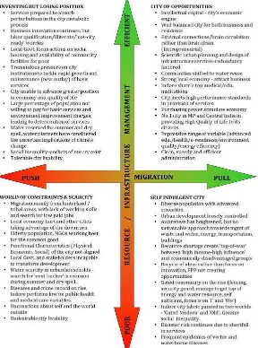
The Risk to Resilience Workshops identified two major uncertainties that would determine the growth of )ndore. a Migration Pattern and b City Level Resource/ )nfrastructure Management.
a Migration Patterns:
The city is located in the semi-arid zone with high variability in annual rainfall. Also, it is
surrounded by complex, diverse risk-prone agricultural region lying in rain-shadow zone of
Western Ghats. The terrain is hilly especially towards west and south. The land quality is poor and per capita cultivable land is low. )t is inhabited by a mix of tribal and caste population who are predominantly poor.
Any change in climate can further increase the risk to subsistence agriculture and rural population is forced to migrate to the nearby cities, with economically stronger )ndore becoming the destination for the migrants. These rural migrants are skilled poor and the city economy may be affected by the push migration.
On the other hand, )ndore may attract skilled workers with the growth of secondary and tertiary sectors. )ts current potential to attract educational and medical institutions will be an added advantage. Such pull migration is likely to result in demand for better services and ability to pay for better services. Therefore, the migration pattern will be most important critical uncertainty for the future
b City level resource / infrastructure management:
Since )ndore city is more dependent on distant water resource i.e. Narmada River to meet its growing water demands, the cost recovery will be a challenge for managing water infrastructure of the city. Also, the increasing energy costs can add additional burden on the )MC. The maintenance as well as capital investments required will depend on the city s ability to recover the costs. Considering the huge gap in municipal finances, the ability to charge the consumers and to maintain the infrastructure will be another major critical uncertainty. Figure provides a schematic view of the two critical uncertainties i.e. improvement or deterioration in city level resource/infrastructure management in tandem with the city s migration pattern and possible outcomes that could arise.
Critical Uncertainties & Scenarios
.
Critical Uncertainties: Migration and
Migration patterns & Resource/
)nfrastructure Management
.
Scenarios
Social
Cohesion
Physical / Environmental Social Economic
. Scenarios
Resource Use Growth Under Various Scenarios: Critical issues:
Two critical issues will determine the use of resources and quality of services.
First, is the issue of technological options for conservation and reuse. Over next two decades, several technologies and systems are expected to emerge to improve energy use and water reuse options. (owever, these would require concentrated efforts and investments to implement these technologies and processes. The experience so far indicates that )MC has continued to depend on new investments on capital infrastructure without focusing on reducing leakages and wastage of existing local resources, while many other cities have already gone ahead with demand side and supply side interventions. Secondly, the actions for meeting demands for services and better governance are required for change. This should also take care the capacity building and harmonization of changes in the system as a whole requiring lots of efforts. At the administration level, the willingness to change is not pervasive. Continued donor involvement has not resulted in major changes and most of the changes are transient. Citizen involvement is more critical and their constructive and constant engagement is necessary for change.
Resource use:
Under pull migration led growth scenario, the resource use is likely to grow more than the population growth as indicated in energy sector study. As seen in the past, actual demand is likely to overshoot the demand projections used for designing new infrastructure. The ability of the )MC to improve resource use efficiency will be critical in maintaining the lowest possible growth in demand and increasing reliance on high energy demanding external resources.
Under push migration led scenarios, the growth rate of resource consumption is expected to be much lower due to low capacity to pay and no significant change in quality of life. Poor O&M will also result in continued high losses.
The urban growth have significant impact on the city s natural environment. (igh population growth may increase the demands, which cannot be met concurrently with the poor infrastructure, poor financial condition of the urban local body, lack of capacity, issues of political will and consensus. This would mean partial solutions leading to worsening of the urban environment. This may affect water supply, drainage, sewerage and solid waste management. Unless there is a paradigm shift among institutions, planning, infrastructure design and management of services, the environmental conditions are likely to worsen. Climate change is likely to add to above mentioned problems.
Water supply &
Advisory Committee, four future scenarios were developed. This provide a combination of push or pull migration and resource/ infrastructure management. This scenario reflect the situation which may appear for the year - time period and arebased on the set of certainties and uncertainties identified by CAC members.
Physical / Environmental Social Economic
(ealth | Social Cohesion | )nstitutional