© Springer-Verlag Berlin Heidelberg 2015
R. Intan et al. (Eds.): ICSIIT 2015, CCIS 516, pp. 529–538, 2015. DOI: 10.1007/978-3-662-46742-8_48
Public Transport Information System Using Android
Agustinus Noertjahyana, Gregorius Satia Budhi, and Agustinus Darmawan Andilolo
Informatics Engineering, Petra Christian University Jl. Siwalankerto 121-131 Surabaya, 60236
{agust,greg}@petra.ac.id, [email protected]
Abstract. Traffic jams are getting higher, making people surabaya thinking of switching from private to public transport vehicles. But the problem that arises is the lack of information about public transportation in Surabaya, so it is quite difficult for people who want to use public transport for transportation.
With the development of technology, especially in the smartphone, which is almost used by most people, the idea emerged to develop an application that can provide information related to public transport service based on mobile technology. Android platform chosen for the current smartphones starting from the lowest price to the highest price is dominated by the Android operating sys-tem. Applications developed to help people to be able to choose the transport used while traveling from one place to a particular destination with as little ef-fort as possible. The application is able to assist the selection of an appropriate route, either directly or indirectly.
Keywords: Android, Information System Transportation, Mobile Device.
1
Background
Android-based smart phone technology is increasingly being used by the community. Various types and brands of smart phones that both local and global enliven the smart phone market.
The development of technology and prices are getting cheaper, smart phone with cheap price also is equipped with GPS (Global Positioning System) [1], a technology that can help to find a location from anywhere. This is very helpful in providing in-formation about a location.
Surabaya as the second largest city in Indonesia, have problems in the public trans-port system. Many people began to leave the public transtrans-port as the main option in meeting the transportation needs because quite difficult to get information about the route of public transport [2].
So many public transportation but very little information is available either through the mass media and the Internet. For those reasons, by utilizing the Android technolo-gy, where this technology is quite cheap and more people are using it, then this is a pretty interesting idea to be able to develop applications that can help to provide in-formation about public transport service in the city of Surabaya [3].
Applications developed will be able to help people in Surabaya to maximally util-ize public transportation, and even not only the indigenous people of Surabaya but also newcomers can take advantage of public transportation in Surabaya [3].
2
Theory
2.1 Public Transport
Transportation system plays an important role in economic development in an area. The better the transportation system of a region, it will have a positive impact on the economic development of the region [4].
Surabaya, the capital of East Java province, is the second largest city in Indonesia after Jakarta. Surabaya city has grown rapidly in terms of trade and population growth. This leads to the need of transportation have increased significantly. The number of private vehicles, according to data of East Java Police has reached more than 4 million units [5].
With the number of private vehicles is large enough, then Surabaya experiencing traffic congestion problems. To overcome traffic congestion, then the people of Sura-baya should be encouraged to switch to public transport. For those reasons, the level of comfort and reliability of the public transport system of choice for workers, stu-dents and the community at large.
The main problem in Surabaya is information about public transport. People in Su-rabaya have difficulty in accessing information about public transportation route, so there is a tendency to use private vehicles.
2.2 Public Transport Profile
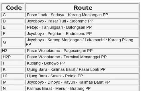
Public Transportation in Surabaya consist of: City Bus, Public Passenger Cars (MPU), trains and ships. However, the focus of this research is on Passenger Cars (MPU). Each route has a specific code that is set by Organda (Organisation of Na-tional Transport Vehicle On Road). List of routes MPU in Surabaya is in Table 1 [6].
Table 1.
G Joyoboyo - Karang Menjangan / Lakarsantri / Karang Pilang PP
H2 Pasar Wonokromo - Pagesangan PP
H2P Pasar Wonokromo - Terminal Menanggal PP
I Kupang - Benowo PP
K Ujung Baru - Kalimas Barat / Pasar Loak PP
L2 Ujung Baru - Sasak - Petojo PP
M Joyoboyo - Dinoyo - Kayun - Kalimas Barat PP
Table 1. (Continued) Joyoboyo - Karang Menjangan - Kenjeran PP
Q Kalimas Barat - Bratang PP
2.3 Android
Android is a software for smartphones that includes an operating system, middleware and key applications that are released by Google [7].
To make it easier to develop applications on the Android platform requires Adroid SDK, Tools API (Application Programming Interface) using the Java programming language.
Android Development Tools (ADT) is a plugin that is designed for the Eclipse IDE that make it easier to develop Android applications. By using ADT for Eclipse, it will be easier to create applications Android project, create a GUI application, and add other components. In addition, it can build Android package (.apk) that are used to distribute Android applications.
2.4 Google MAPS
Google Maps is an online map application service provided by Google for free. Google Maps officially accessible through the site http://maps.google.com. Service is very interactive google maps, maps in the slide according to user needs and the level of zoom can be adjusted [8].
Google Maps has many features that can be used eg location search based on cer-tain keywords, such as a name, city, or road, and able to perform the calculation of the travel route from the starting location to the destination.
3
Design System
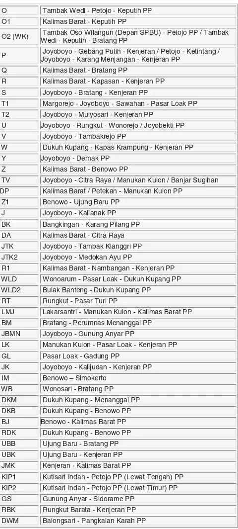
3.1 System Architecture
Referring to the public transport route as in Table 1, the transport information system developed using google maps to perform routes calculations, and data is saved to the server that can be accessed via the Internet.
There are two functions in the system: administrator and user. The administrator in charge to enter all the data into routes server, while the user is only able to request to the server on a particular routes, and the server provides the results to the user.
System architecture diagram can be seen in Figure 1.
3.2 Design Flowchart
Design Flowchart of Administrator Function can be seen in Figure 2.
Fig. 2. Flowchart of Administrator Function
3.3 System on Android
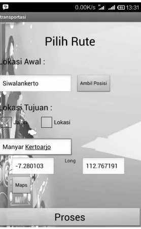
Android system begins with the way the user make a selection starting location and destination.
At the destination, the user has three options: choose a destination by street name, place name, or select from the map.
Next the system will process and deliver the results to the user. When user presses the button MAP, then the user will be taken to a page that displays the position of each path traversed by public transport.
4
Implementation
4.1 Web Administrator
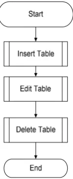
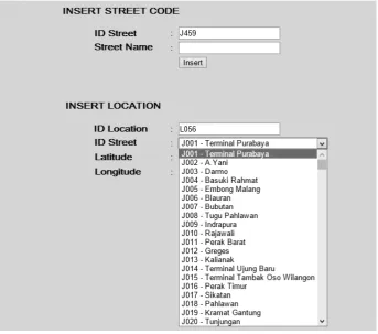
On the Web Administrator, there is a page to add street code and name of the street. When Insert button is pressed, the new data will be entered into the database.
Latitude and Longitude are used to store data based on the existing location on the map. The function of the web administrator can be seen in Figure 3.
Fig. 3. Web Administrator
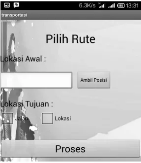
4.2 Implementation on Android
Implementation of Transport Information System in the form of Android-based applications. The main page of the application can be seen in Figure 4. There is an input to enter the starting location (Lokasi Awal), or take a position on the map (Ambil Posisi).
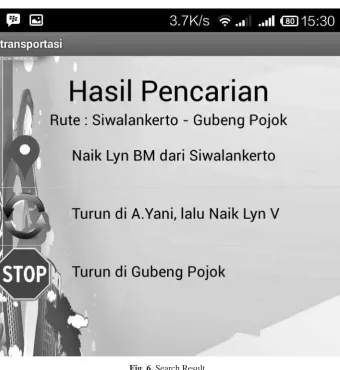
Search results based on the location of the start and destination can be seen in Figure 6.
Fig. 6. Search Result
5
Conclusion
References
1. Anderson, R.E.: Building a Transportation Information System Using Only GPS and Basic SMS Infrastructure (2009), http://depts.washington.edu/ddi/ publications/ictd_2009_starbus_final.pdf
2. Dwiky, A.: Desain Dan Implementasi Sistem Informasi Rute Angkutan Umum Daerah Su-rabaya Menggunakan Visual Basic 6. SuSu-rabaya. UPN Veteran, Jawa Timur (2012)
3. Andilolo, D.A., Agustinus, N., Gregorius, S.: Perancangan Dan Pembuatan Aplikasi Infor-masi Transportasi Umum Di Surabaya Berbasis Android Surabaya. Universitas Kristen Pe-tra (2014)
4. Weisbrod, G.: Models to predict the economic development impact of transportation projects: historical experience and new applications. The Annals of Regional Science 42(3) (September 2008)
5. Anonim (2013), http://www.surabayakita.com/index.php?option=com _content&view=article&id=5679:tambah-tahun-surabaya-tambah-macet&catid=25&Itemid=0
6. Profil Transportasi Kota Surabaya, http://www.surabaya.go.id/ infokota/index.php?id=7 (last accessed December 29, 2014)
7. Safaat, N.: Pemograman Aplikasi MobileSmartphone and Tablet PC Berbasis Android. Pe-nerbit Informatika, Bandung (2012)