Stratigraphic constraints on suture models for eastern Indonesia
J. Milsom
Department of Geological Sciences, University College London, London WC1E 6BT, UK Received 10 May 2000; accepted 29 June 2000
Abstract
Although collision in eastern Indonesia is now accreting the Australian continent to Southeast Asia, the small North and South Banda oceanic basins within the suture zone are interpreted as Late Cenozoic extensional features. Stratigraphic columns from the surrounding islands conform to one of three generalised patterns, two of which can be related to the margins of SE Asia (Sundaland) and the Australian continent, respectively. The third system, which is dominant in the outer Banda Arc and eastern Sulawesi, is associated with a microcontinent that was rifted from Australia in the Jurassic, drifted northwards ahead of Australia in the Cretaceous and collided with the Sundaland Margin in the Paleogene. Subsequent collapse of the resulting collision orogen led to rapid extension and the formation of the Banda Sea behind the Outer Banda Arc thrust belt. Eastern Indonesia thus duplicates a pattern familiar in the Mediterranean. The Tertiary compressional structures of the region cannot be explained solely in terms of the most recent collision, which began only in the Pliocene.q2000 Elsevier Science Ltd. All rights reserved.
Keywords: Eastern Indonesia; Banda Arc; Eurasian Plates
1. Introduction
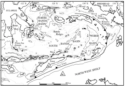
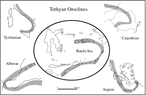
Suturing of northern Australia to SE Asia takes place within a diffuse and still poorly understood region (Fig. 1) where relative motions between the Indo-Australian and Eurasian Plates are absorbed by subduction beneath the Sunda Arc and collision around the strongly curved Banda Arc. The plate boundary, which south of the Sunda Arc is marked by a deep trench, is replaced in the Banda Arc by a series of relatively shallow troughs. There is no significant offset in the line of active and recent volcanoes but the two forearcs are very different. Except in the area to the west of Sumatra, the Sunda forearc ridge is entirely submarine, but the Banda forearc (Outer Banda Arc) is capped by large islands such as Timor, Tanimbar, Seram and Buru (Fig. 1). The origin of the back-arc Banda Sea is still unclear, with some authors (e.g. Silver et al., 1985) regarding the oceanic parts as trapped slices of Indian Ocean or Molucca Sea crust, while others (Hamilton, 1979; Re´hault et al., 1994) have argued in favour of Neogene extension. A pattern of local extension in an overall collisional environ-ment suggests analogies with the Mediterranean, where continental collision has produced deep basins floored by attenuated continental crust in the Alboran and Aegean seas and by oceanic crust in parts of the Tyrrhenian Sea (Dewey,
1988). The Mediterranean basins resemble the Banda Sea, not merely in size, but also in being partly enclosed by orogens with total curvatures approaching 1808(Fig. 2).
Many of the allochthonous terranes which make up east-ern Indonesia are of Australasian origin. This is true not only of the large landmass of New Guinea, which is still linked to Australia, but of many of the smaller islands on the Asian side of the collision suture. Some of this material has been transferred from Australasia to Eurasia during the Pleistocene and continuing Banda Arc collision, but other fragments must have been accreted earlier. Two important ‘Australian’ elements are Buton Island, southeast of Sula-wesi, and the Banggai and Sula Islands, which form the Sula Spur (Fig. 1). There is a wide measure of agree-ment (Hamilton, 1979; Milsom, 1985; Silver et al., 1985) that the Sula Spur is a fragment of New Guinea which was transported west along transcurrent faults during the late Tertiary. Observations made in the course of oil exploration programmes have dated its collision with the East Arm of Sulawesi to between 5.2 and 3.8 Ma (Davies, 1990).
The history of Buton, which collided with the Sundaland Margin much earlier, in the Early or Middle Miocene, is more controversial (Davidson, 1991). One school of thought considers it to have also come from the Birdshead (Smith and Silver, 1991), but the correlations with New Guinea are less convincing, whereas the Mesozoic sediments are
Journal of Asian Earth Sciences 18 (2000) 761–779
1367-9120/00/$ - see front matterq2000 Elsevier Science Ltd. All rights reserved. PII: S 1 3 6 7 - 9 1 2 0 ( 0 0 ) 0 0 0 3 5 - 3
www.elsevier.nl/locate/jseaes
virtually identical to those on the northern Banda Arc islands of Buru and Seram.
The Australian-derived fragments listed above all contrast strongly with Sumba, the westernmost island in the Outer Banda Arc (Fig. 1), which resembles SW Sula-wesi. Thus, and in very simple terms, the geology of eastern Indonesia can be summarised by three generalised associa-tions of sedimentary, metamorphic and igneous rocks, of which two are related to the continental margins of South-east Asia (Sundaland) and Australasia, respectively. The third, Banda, association is dominant in and around the Banda Sea. The stratigraphic data, while not defining the entire history of the suture zone, can be used to constrain the range of acceptable hypotheses.
2. Sundaland Margin Association
Subduction at the Sundaland Margin can be traced back into the Cretaceous, and the exposed metamorphic rocks are thought to represent Cretaceous accretionary complexes. Conditions changed in the Oligo-Miocene as a result of collision with a microcontinent and many of the younger rocks record extension rather than compression.
2.1. SW Sulawesi
SW Sulawesi is the end product of a series of volcanic episodes that began in the late Mesozoic, when the block was joined to eastern Borneo, but continued after the Eocene opening of the Macassar Straits (Polve´ et al., 1997). Meta-morphic basement complexes exposed in the Barru and Bantimala areas of SW Sulawesi (Wakita et al., 1996) and farther north in the Latimojong area (Bergman et al., 1996) are in thrust or depositional contact with weakly metamor-phosed deep marine clastics of the Upper Cretaceous Balangbaru Formation. Carbonates were deposited in two main periods, in the Eocene–Oligocene and Miocene (Wilson and Bosence, 1996). Volcanogenic sediments are widely distributed, especially in the fault-bounded Walanae depression that developed following the Late Oligocene or Early Miocene collision, which sutured western and eastern Sulawesi. Volcanic rocks with ages ranging from 2 to 18 Ma, but concentrated around 8 Ma, were interpreted by Bergman et al. (1996) as evidence for orogenic collapse and extension, their chemistries being consistent with partial melting at the base of an extending, collision-thickened and possibly delaminating lithosphere. This conclusion was endorsed by Polve´ et al. (1997), who noted the J. Milsom / Journal of Asian Earth Sciences 18 (2000) 761–779
762
comparative scarcity of conventional subduction-type calc-alkaline rocks with Neogene ages. The geological evolution of western Sulawesi is summarised by the stratigraphic column of Fig. 3a, which does not, however, include the important but controversial Lamasi Complex. The date of emplacement of this deformed, metamorphosed and thrust bounded ophiolite (Bergman et al., 1996) is not known but the mid-Tertiary orogenic phase is an obvious possibility.
2.2. Flores Sea Islands
Bouguer gravity levels indicate that the northern part of the Flores Sea, south of Sulawesi, is underlain by thinned continental crust, but that there is oceanic crust further south (Silver et al., 1986). The small and scattered islands within the sea have been described by Guntoro (1995) as closely related to the longitudinally corresponding areas of Sula-wesi, with acid igneous rocks in the west and more basic igneous rocks in the east. A volcanic sequence (Old Volca-nic Breccia) in the western islands is equivalent to the Langi Volcanics of SW Sulawesi, and the unconformably over-lying bioclastic limestones, reliably dated as Oligocene, are equivalent to the upper, bioclastic, units of the Tonasa Limestone described by Wilson and Bosence (1996). Wide-spread calc-alkaline and alkaline, granitic to rhyolitic pluto-nic and volcapluto-nic rocks have not been dated, and their
contacts with other rocks have not been seen, but they contain dioritic xenoliths interpreted as belonging to the Old Volcanic Breccia. These suggest an age no greater than Eocene and a probable correlation with the Early to Middle Miocene granites of SW Sulawesi.
Volcanic activity recommencing in the Pleistocene, produced the Young Volcanic Breccia, which consists of conglomerate, volcanic tuff and volcanic breccia of andesi-tic and basalandesi-tic composition. Alkaline andesiandesi-tic and basalandesi-tic dykes and sills intrude all units except the Quaternary coral limestones. As in western Sulawesi, the combination of calc-alkaline and alkaline chemistries suggests both subduc-tion and extension.
2.3. Sumba
The Flores Sea Islands form a partial link between SW Sulawesi and the Outer Banda Arc island of Sumba (Fig. 1), which lies to the west of the region of current arc-continent collision. The position of Sumba, and the absence there of any Australasian material, is evidence that the large islands of the Outer Arc do not owe their existence solely to accre-tion in the course of the present-day collision.
The oldest rocks exposed on Sumba are Cretaceous open marine sediments of the Lasipu Formation, described by Wensink (1997) as identical to the Balangbaru of SW J. Milsom / Journal of Asian Earth Sciences 18 (2000) 761–779 763
Tethyan Oroclines
Banda Sea
Aegean
Alboran
Carpathian
Tyrrhenian
0 500 km
J.
Milsom
/
Journal
of
Asian
Earth
Sciences
18
(2000)
761
–
779
764
EARL
Y
EARL
Y
CRET
AC
E
O
U
S
CRET
A
CEOUS
MESOZOIC MESOZOIC
CENOZOIC CENOZOIC
LA
TE
LA
TE
PLIOCENE PLIOCENE
MIO-CENE CENE
MIO-
OLIGO-CENE OLIGO-CENE
PALEO-CENE PALEO-CENE
EOCENE EOCENE
100 100
50 50
0 0
BALANGBARU FORMATION LASIPUFORMATION
BARRU, BANTIMALA AND LATIMOJONG COMPLEXES
LANGI VOLCANICS
JAWILA VOLCANICS
SW SULAWESI
SUMBA
MALA WA
FORMATION MASU
FORMATION TONASA
LIMESTONE FORMATIONPAUMBAP A
TACIPI MEMBER
QU ATERNARY REEF
CAMBA FORMATION
KANANGGAR WAIKABUBAK
WALANAE FORMATION
Tectonic melange; sandstones, shales,
cherts, basalt ultramafics and
schists Deep marine
clastic sediments Turbidites andsubmarine fan
deposits Tholeiitic and
calc-alkaline volcanics
Tholeiitic and calc-alkaline
volcanics Carbonate platform with
redeposited marginal facies including platform carbonatesShallow marine sediments
Volcaniclastics Carbonate
platform
Shallow marine
clastics Reef limestones
Shales
Coals
? ? ?
Neritic
Sediments Chalk and reef limestones
Volcaniclastics
3a 3b
J. Paralic to shallow marine clastics
and carbonates Marine clastics deposited at a wide variety of depths
TR FLAMINGO GR OU P
TIPU MA quartz sandstone and siltstone
Dense, well bedded calcilutite
Micaceous glauconitic and micaceous sands and silts
Argillaceous, glauconitic and calcarous quartz sandstone
and silty mudstone
Continental redbeds
Nonmarine, lacustrine and paralic sediments, some coals
Shallow water platform carbonates with isolated reefs
Sandstones
J. Paralic to shallow marine
and fluvial clastics
SU LA SPUR
MISOOL
MANGOLE
BOBONG FOR MATION POLYSEQU ENCEINANWATAN YEFBI
SHALE paralic sediments, some coals FAFANLAP FOR MATION
DARAM SANDSTONE Z AAG LIMESTONE KASIM MAR LSTONE
ATKAR I LIMESTONE Fine-grained calcarenite
Calcarenite with minor oolite
FACET H ighly fosilliferous pelagic
limestones Shallow water platform carbonates with isolated reefs
Shallow marine carbonates with localised reefs
Subaerial acid volcanics Continental redbeds
Paralic to shallow marine clastics and carbonates
Sulawesi. Mid-Cretaceous dinoflagellates suggest a North Tethys affinity (Fortuin et al., 1997). The upper age limit of the Lasipu is uncertain, but there was widespread igneous activity in the Late Cretaceous and Paleogene. The Jawila Volcanics, originally thought to be Early Miocene, have now been dated as Late Eocene (Fortuin et al., 1997) and can be regarded as part of a belt that includes the Langi Volcanics of Sulawesi and the Old Volcanic Breccia of Tanahjumpea. Also in the Eocene, a platform developed and, as with the Tonasa of SW Sulawesi, remained a site of carbonate sedimentation (Paumbapa Formation) into the Early Miocene (Fortuin et al., 1997). The Paleogene sedi-ments are truncated by a Middle Miocene angular uncon-formity above which reef carbonates, chalks and volcanoclastic turbididites were deposited. The stratigraphy of Sumba is summarised in Fig. 3b; the similarities to SW Sulawesi are clear and are enhanced in both areas by the presence of Eocene granodioritic intrusions.
Extensive paleomagnetic work (Wensink, 1997) has provided additional support for a Late Mesozoic position of Sumba close to western Sulawesi, followed by detach-ment and a complicated series of rotations, the net effect of which has been some 908 of clockwise rotation. This contrasts with the mounting evidence for counter-clockwise rotation of Kalimantan and western Sulawesi (Fuller et al., 1999).
2.4. Sundaland Margin summary
The diagnostic features of the Sundaland Margin strati-graphy include Upper Cretaceous–Paleogene deep-water clastic sediments, volcanics which are of island arc type in the Paleogene but extensional in the Neogene, and the development of large carbonate platforms in the Eocene– Early Miocene. The type area is the South Arm of Sulawesi and, in particular, the region northeast of Ujung Pandang (Fig. 1). Similar, although not always complete, Mesozoic and Paleogene sections can be recognised in the Flores Sea Islands and Sumba. Sediments above the mid-Miocene angular unconformity, which is a feature of the association, show fewer common characteristics, which is unsurprising if dispersion began during the unrecorded interval. Disper-sion, and the generation of oceanic crust in the Flores Sea, must predate the Late Neogene development of the eastern Sunda/Banda volcanic arc, because this lies to the north of Sumba. Since the volcanic islands from Flores to Wetar separate two Sunda-related blocks, it is possible, and perhaps even probable, that they are themselves built on Sundaland basement, although this is nowhere exposed.
3. Australasian Margin Association
Sediments were deposited along the Australian Margin under terrestrial or marginal marine conditions in the Trias-sic and JurasTrias-sic and in deeper water during and after the Cretaceous. Basement rocks in the east belong to a Late
Paleozoic orogenic belt and in the west to a craton covered by Paleozoic platform sediments. Anomalously, ‘eastern’ granitic basement crops out in the Banggai Islands (Fig. 1), the most northwesterly Australasian fragment. Neogene sediments vary widely due to differences in setting in rela-tion to the collision orogenies.
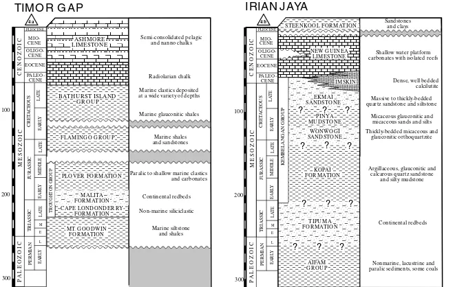
3.1. The Northwest Shelf
During the Paleozoic, north-western Australia formed part of the interior of the Gondwana super-continent, but rifting in the Triassic and Jurassic detached India and other blocks and created new passive margins along the Northwest Shelf. Sediments deposited at these margins are almost nowhere seen in outcrop but are known from numer-ous wells. The stratigraphy of the shelf to the south of Timor has been described and compared with stratigraphies in adjacent areas by Brown (1992). Three major sedimentary groups were recognised, these being the Triassic–Jurassic Troughton Group, the Jurassic–Cretaceous Flamingo Group and the Middle and Upper Cretaceous Bathurst Island Group (Fig. 4a). Troughton group sediments are predomi-nantly siliciclastic and include red beds in the Malita Forma-tion, which is of latest Triassic and earliest Jurassic age. Marine transgression followed, with deposition of the fluvio-deltaic sediments of the Jurassic Plover Formation. There are no sediments which can be unequivocally assigned to a rift/break-up setting before the Late Jurassic when, as a result of rifting, an unconformity developed on which the sandstones and shales of the Flamingo Group were deposited under deeper marine conditions. Generally similar sediments characterise the Bathurst Group, depos-ited following an Early Cretaceous hiatus, but the sea had evidently deepened still further. Radiolarian shales were deposited in the Aptian to Early Albian and a black clays-tone with high gamma-ray signature represents a condensed sequence in the Turonian to Coniacian. Chalks were then deposited, which were dominantly radiolarian in the Late Cretaceous and foraminiferal in the Paleocene through to the Pliocene (von Rad and Exon, 1983). Harris (1991) noted strong similarities between these sediments and the Lower Cretaceous Kolbano Series of Timor.
3.2. New Guinea
between the main body of New Guinea and the smaller islands of eastern Indonesia, presents particular problems. It is widely thought to have moved independently for much of its history (cf. Hamilton, 1979) and some movement relative to New Guinea continues to the present day (Punto-dewo et al., 1994). The core of the peninsula is formed by the Birdshead/Kemum Terrane of Struckmeyer et al. (1993), in which metamorphosed Siluro-Devonian turbidites have been intruded by Carboniferous and Permo-Triassic grani-toids and are overlain by Late Paleozoic shallow marine clastics and Triassic to Lower Jurassic continental redbeds. Marginal marine conditions were re-established in the early Middle Jurassic and continued throughout the Mesozoic and into the early Tertiary, interspersed with periods of erosion and non-deposition (Dolan and Hermany, 1988). Sediments deposited during this long interval have traditionally been assigned to the ‘Kembelangan Formation’ (Visser and Hermes, 1962) but the term has been used in such a variety of contexts that it has become virtually meaningless (Fraser et al., 1993). The stratigraphic column of Fig. 4b is based on the more westerly of the New Guinea stratigraphies presented by Pieters et al. (1983).
Shelf carbonates (New Guinea Limestone, Visser and Hermes, 1962) dominate the Tertiary throughout New Guinea but deposition on the Birdshead was interrupted by a period of folding and erosion in the Late Oligocene.
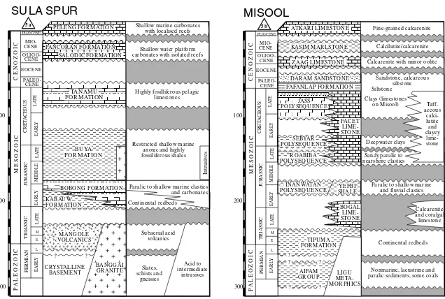
3.3. The Sula Spur
The Banggai and Sula Islands, which lie immediately to the north of the North Banda Basin and the northern limb of the Banda Arc, were transported from the New Guinea region to their present position by transcurrent movements along strands of the Sorong Fault System (Hamilton, 1979; Pigram et al., 1985). Basement consists of poorly known metamorphics but there are also granitic rocks of assumed Paleozoic age. The Triassic is dominated by the acid Mangole Volcanics and by probably co-magmatic Permo-Triassic granites. Sedimentation, generally in marine basins with restricted circulation and water depths of less than 200 m, was almost continuous throughout the Jurassic but a ‘break-up unconformity’ (Garrard et al., 1988) occupies much of the Cretaceous. Following this break, bathyal sedi-ments were deposited during the Late Cretaceous and Paleo-cene (Garrard et al., 1988). A second hiatus occupied much of the Eocene but thereafter carbonate platform sedimenta-tion continued almost uninterrupted until the onset of colli-sion with East Sulawesi in the latest Miocene (Davies, 1990). Davidson (1991), amongst others, has suggested correlations between the Sula Spur and Buton and the Outer Banda Arc but the statigraphic sequence described above and summarised in Fig. 5a has virtually nothing in common with either of these areas.
3.4. Kai Besar
Seismic reflection surveys near the Kai islands (Fig. 1)
have shown that the plate suture runs between Kai Besar and Kai Kecil, rather than through the Aru Trough (Milsom et al., 1996). The oldest rocks exposed on Kai Besar, on the Australian side of the suture, are Eocene flat-bedded calcilutites and marls. Shallow-water carbonates were deposited from the Oligocene almost to the present day. This stratigraphy is not significantly different from the end-Cretaceous to Late Miocene succession on the Sula Spur.
3.5. Misool–Onin–Komewa
The Late Oligocene compression widely observed in the Birdshead was interpreted by Struckmeyer et al. (1993) as due to a collision with a Misool–Onin–Komewa Terrane. On Misool island a Paleozoic basement of folded and meta-morphosed turbidites is overlain by an almost complete Mesozoic passive margin sequence of Triassic turbidites, Upper Triassic shallow-water limestones and Lower Juras-sic to Upper Cretaceous bathyal clastics and carbonates (Rusmana et al., 1989). Outcrop information on the geology of Misool and the related Onin and Komewa peninsulas of the New Guinea mainland (Fig. 1) has been supplemented by drilling, and Fraser et al. (1993) used subsurface data from both the Misool–Onin–Komewa province and adja-cent parts of the Birdshead to develop a new scheme to replace the Kembelangan nomenclature. In this scheme the Mesozoic sediments were divided into a Lower to Middle Jurassic shallow marine to fluvial ‘Inanwatan Poly-sequence’, a Middle to Upper Jurassic paralic to nearshore ‘Roabiba Polysequence’, an Upper Jurassic–Lower Cretac-eous deepwater open marine ‘Sebyar Polysequence’and an Upper Cretaceous to Paleocene, ‘Jass Polysequence’, sepa-rated by major unconformities (Fig. 5b). In the crucial TBJ-1X well (Fig. 1) off the Onin Peninsula (and therefore within the Misool–Onin–Komewa Province), section is missing from the Middle Triassic to the base of the Toarcian, from the top of the Bajocian to the base of the Oxfordian, from the Lower Kimmeridgian to the mid Tithonian and from the Lower Valangian to the Cenomanian. Jass sediments have also largely been removed from the well section by erosion. Elsewhere, the Cenomanian base of the Jass is marked by a volcanic event and the overlying sediments are mainly deepwater clays, although shallow water rudists outcrop in the Misool archipelago.
Fig. 5b shows that there are considerable differences between the rocks outcropping on Misool and those inter-sected in TBJ-1X. Whereas the well section fits into the pattern of the Australian Margin Association, Misool has much in common with the Banda Association described below, although it reportedly lacks the characteristic Juras-sic unconformity. Moreover, palaeomagnetic data indicates that the island was more than 1000 km north of Australia in the Cretaceous (Wensink et al., 1989). There is thus a clear possibility that Misool was detached from the Australian Margin as an independent fragment in the Mesozoic and J. Milsom / Journal of Asian Earth Sciences 18 (2000) 761–779
J.
Pelitic phyllite and slate with subordinate quartzose
and micaceous sandstone White to pink
nannofossil-microfossil pelagic limestones, some cherts Well laminated calcilutite
with local clastic detritus Reef Limestone Pelagic foraminiferal marly chalk
Coarse to fine grained terrigenous clastics
LATE CR ETACEOU S NIEF BEDS PALAEOGENE
NIEF BEDS
KOBIPOTO COMPLEX TAU NU SA COMPLEX
Coralli-Cream and white calcilutites
red and green marls
Medium - high grade schists and gneisses.
TEH OR U FOR MATION
NI
EF
B
E
DS
EARLY NEOGENE NIEF BEDS WAHAI BEDS SALAS EAR LY NIEF BEDS
MANU SELA
collided with the Birdshead in the Mid-Tertiary, when the older sediments were folded. More detailed work is needed on the Mesozoic rocks, which are well exposed on the south coast of Misool and the islands immediately to the south, to clarify their role in the regional evolution.
3.6. Australian Margin summary
The wide variations in Australian Margin stratigraphies are not surprising in view of the vast area covered. The type area for the association is taken to be the shelf south of Timor (the ‘Timor Gap’). Western Irian Jaya, including the Birdshead, and the Sula Spur, are included in this asso-ciation but their basements of Late Paleozoic granites and associated extrusive rocks have more in common with central Papua New Guinea than the Northwest Shelf. Misool island is different again and lacks the terrestrial Triassic ‘red beds’ deposited elsewhere in the region prior to, and at the beginning, of the break-up of this part of Gondwanaland.
The later Mesozoic in all areas records a steady increase in water depth, from marginal marine in the Jurassic to open water bathyal in the later Cretaceous. During the Tertiary, parts of the margin were fragmented and/or involved in collisions, and Tertiary stratigraphies therefore differ considerably.
4. Banda Association
The Banda Association, which is found on the islands surrounding the Banda Sea, progresses from Upper Triassic to Lower Jurassic shallow water clastics and carbonates which are richly fossiliferous and sometimes bituminous, via unconformity to an Upper Jurassic to Paleogene condensed sequence of deep water carbonates and cherts from which clastic components are almost completely absent. The Middle to Late Jurassic hiatus is an important diagnostic feature. It is widely recognised on the Australian J. Milsom / Journal of Asian Earth Sciences 18 (2000) 761–779
770
La
wanopo
Fault
Undifferentiated Mesozoic
Cretaceous limestone
Jurassic limestone
Jurassic/Triassic clastics
J. marl and shale in the
upper parts Coarse to fine grained
terrigenous clastics
Northwest Shelf, where it was termed ‘Wombat-type’ by Gradstein (1992) following ODP drilling on the Wombat Plateau. There are many similarities between the Mesozoic sediments of the Wombat Plateau and the Banda Associa-tion. However, whereas the Mesozoic of the plateau rests on a thick unmetamorphosed Paleozoic section, metamorphic rocks, upon which the Triassic sediments are said to rest unconformably, are common in the Banda Association, as are Cretaceous–Paleocene ophiolites. Stratigraphies in the various Banda fragments diverge significantly only after the Oligocene, when many of the blocks were deformed by thrusting.
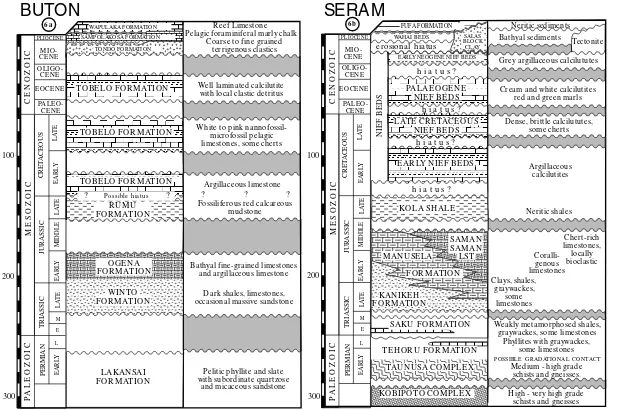
4.1. Buton
Buton is one of the most important islands of the Banda Association because of its present close proximity to Sula-wesi (Fig. 1). Drawing in part on work by Fortuin et al. (1990) and De Smet and Hermanto (1991), Davidson (1991) deduced separation from Australia in the Late Trias-sic or Early JurasTrias-sic and a transition from pre-rift to syn-rift sedimentation in the Middle to Late Triassic. The Triassic rocks (Winto Formation) rest on pelitic phyllites and slates (Lakansai Formation) which are exposed over an area of only about 40 km2 in the northeast of the island (Smith and Silver, 1991). Both the Winto and the overlying Lower Jurassic Ogena Formation consist dominantly of limestone, but the Ogena appears to have been depos-ited in deeper water. Clastic sediments, principally shales, are common in the Winto of southern Buton. Both formations contain abundant organic material that is generally considered to be the source of the island’s asphalt deposits.
The poorly exposed later Mesozoic on Buton begins with deep marine siliceous and calcareous mudstones of the Upper Jurassic Rumu Formation and continues with the pelagic limestones with nodules and stringers of red chert of the Tobelo Formation. The Tobelo was originally classi-fied as entirely Upper Cretaceous but has now been shown to extend from the end of Rumu deposition up into the late Eocene or early Oligocene (Smith and Silver, 1991). Both the Rumu and the Tobelo were evidently laid down very slowly and their lithologies are consistent with deposition during the drift of an isolated continental fragment.
According to Davidson (1991), a hiatus at the top of the Tobelo Formation can be attributed to collision with SE Sulawesi in the Early and Middle Miocene (N11). Ophio-lites in southern Buton were probably emplaced at about this time, and compression led to uplift and the establishment of an unconformity representing a hiatus of approximately 3 m.y. The basal sediments of the coarse clastic Tondo Formation, immediately above the unconformity, are mainly carbonate detritus but ultramafic and mafic frag-ments become dominant later, indicating uplift of the ophio-lites above sea level.
Tondo Formation deposition was ended by subsidence of Buton to bathyal depths at approximately 5 Ma and the deposition of chalks and marls. Subsequent uplift was accompanied by the development of reefal carbonates. Minor compressional effects can be observed in Upper Pliocene strata, and oblique compression and associated strike-slip faulting may continue to the present day. Quaternary uplift in southern Buton, where spectacular flights of coral terraces rise to almost 500 m above sea level, has been estimated at 2.5 km, but the northern part of the island is now subsiding (Davidson, 1991). The history of post-Middle Miocene molasse deposition and ophiolite emplacement on Buton is virtually identi-cal with that of eastern Sulawesi, and the 5 Ma subsi-dence seems much more likely to have been caused by extensional collapse of the entire Sulawesi orogen, of which Buton formed a part (Milsom et al., 1999), than by the choking of a subduction zone, as suggested by Davidson (1991).
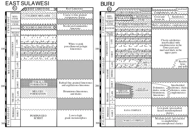
4.2. Buru
The Mesozoic succession on Buru (Fig. 8b) is virtually identical to that on Buton, even though the two islands are separated by the oceanic North Banda Basin (Fig. 1). Bitu-minous Triassic source rocks which are abundantly present in float in rivers in the northwest are directly comparable with the Triassic of Buton, as is most of the Cretaceous section. One distinctive feature of Buru, however, is the presence of some Jurassic igneous material, which may be compared with the rift phase volcanics of the Wallaby Plateau (Gradstein, 1992). Buru also differs from Buton in the abundance of metamorphic rocks, which cover almost the whole of the western two-thirds of the island. These metamorphics were divided by Tjokrosapoetro et al. (1993) into the low grade Rana and higher grade Wahlua Complexes. A recent reconnaissance along new roads into the centre of the island confirmed this distinction (D. Roques, personal communication, 2000).
As on Buton, the depositional environment on Buru became shallower in the Tertiary, but there is no direct evidence for Middle Miocene orogeny. Tjokrosapoetro et al. (1993) described the island as characterised by the absence of thrust faults, imbricated structures, melange or ophiolites. The latest phase of the island’s history has been dominated by very rapid uplift and deposition of thick, coarse alluvial fans (Fortuin et al., 1988). However, steep gravity gradients recently mapped in the southeast of the island are difficult to explain except by the presence of concealed, thrust emplaced, ophiolites.
4.3. Seram
Buru and western Seram were described by Hamilton (1979) as forming a single microcontinent, and certainly the two islands are stratigraphically very similar. For example, parallels have been drawn between the Rana J. Milsom / Journal of Asian Earth Sciences 18 (2000) 761–779
Metamorphics of Buru and the Tehoru Metamorphics of Seram (Linthout et al., 1989). The sediments of Seram were divided into allochthonous and para-autochthonous units by Audley-Charles et al. (1979) but this was rendered unconvincing by disagreement amongst the co-authors as to whether the key Nief Beds, which span the time interval from the Jurassic to the Oligocene, were to be assigned to the allochthon or the para-autochthon. A different view based in part on recent exploration drilling has been offered by Kemp and Mogg (1992). In this scheme, the oldest unme-tamorphosed sediments of Seram belong to the Middle to Upper Triassic, clastic-dominated, near-shore Kanikeh Formation, which grades into Lower and Middle Jurassic deep and shallow water limestones (Manusela and Saman– Saman Formations, respectively) both upwards and later-ally. If these relationships have been correctly interpreted, then all the sediments of Seram can be fitted into a single stratigraphic sequence (Fig. 6b).
The Kanikeh and Saman–Saman are contemporaneous with, and also strikingly similar to, respectively, the Winto and Ogena Formations of Buton. Only the Manusela Formation appears to lack a direct Buton equivalent. In view of the small area of Mesozoic outcrop on Buton, there may be little significance in this absence, or in the apparently different durations of the Jurassic hiatus. The similarities between Buton and Seram continue above the mid-Jurassic unconformity, since the Late Jurassic Kola Shale of Seram resembles the Rumu Formation of Buton and both are over-lain by deep water condensed sequences dominated by fora-miniferal limestones and marls which extend from the Early Cretaceous into the Paleogene (Nief Beds on Seram and Tobelo Formation on Buton). In both the Nief and Tobelo there is evidence for shallower water conditions in the Paleogene and eventual termination of carbonate sedimen-tation in the Miocene.
4.4. Western Kai and the Banda Ridges
Silicic schists, gneisses and migmatites on the western-most islands of the Kai group have been correlated by Charl-ton et al. (1991b) with the Kobipoto Complex of Seram and were considered by Honthaas et al. (1997) as uplifted parts of a former Banda forearc.
Dredging on the high standing ridges (Banda Ridges) in the central Banda Sea has recovered igneous and meta-morphic rocks (Silver et al., 1985), Triassic sediments (Villeneuve et al., 1994) and Miocene reefs (Corne´e et al., 1998). The metamorphics were originally correlated with those of the Birdshead (Silver et al., 1985) but the descrip-tions of the Triassic rocks are much more reminiscent of Buton, Buru and Seram.
4.5. Eastern Sulawesi
The geology of eastern Sulawesi is often described in terms of a simple division into belts of schist and ophiolite separated by the Lawanopo Fault (Fig. 1), but there are
schists to the north of this fault and ophiolites to the south. Patterns of metamorphism are complex. Parkinson (1998) considered that some of the metamorphic rocks formed a high temperature metamorphic sole to the ophio-litic thrusts but it is not clear how widely this interpretation can be applied. Both blueschists and greenschists are present. Metamorphic facies vary and have been used to define a number of distinct formations, but it is possible that these grade into each other. The prevalence of thrusting, and the reconnaissance nature of the mapping in many areas, leave this question open.
Gravity data indicate that the ophiolites overlie the schists on a thrust surface with variable but very shallow dip (Silver et al., 1978). Relatively small south-block up movement along the Lawanopo Fault could have created the present outcrop pattern by exposing the southern parts of the ophio-lite belt to more intensive erosion. Ultramafics south of the Lawanopo Fault, which might represent deep keels to a previously extensive thrust sheet, are associated with occa-sionally strong but very local positive gravity anomalies. If schists, rather than ophiolites, predominate at depth, then their age and origin are important in any regional synth-esis. The most widely held view is that they represent the basement of a microcontinent which collided with western Sulawesi in the mid-Tertiary (Hamilton, 1979). If this is the case, then Australasia seems the most likely ultimate source, although Parkinson (1998) inter-preted the main metamorphic formation, the Pompangeo Schist Complex, as the easternmost extension of the Mesozoic Sundaland Margin, metamorphosed in the Early Cretaceous under intermediate high-pressure conditions.
Mesozoic sediments, metamorphosed slightly or not at all, are often ignored in regional descriptions but are very widely distributed in eastern Sulawesi (Fig. 7). The main periods represented are the Triassic–Lower Jurassic (terres-trial to marginal marine Meluhu Formation and deep water Tokala Formation) and Cretaceous (deep water carbonate-chert Matano Formation). Kundig (1956) estimated the total Mesozoic section as little more than one kilometre thick on the East Arm, but it may be thicker in the Southeast Arm, where the outcrops are more extensive. He also commented on similarities between the Triassic sedi-ments along the southeastern margin of the East Arm, where they form isolated klippen and comprise bitumi-nous limestones and shales, and those of Buru. Surono (1998), in describing the Meluhu Formation, noted that palaeomagnetic determinations placed the site of deposi-tion close to the then latitude of the North Australian Margin.
J.
Claystone and shale with interbedded limestones, calcilutites and siltstones
Interbedded calcilutites and thin shales with radiolaria, foraminifera and chert nodules
Massive to thickly bedded calcarenites, calcirudites
TIMOR (PARA)- AUTOCHTHON
TIMOR ALLOCHTHON
MAU BISSE
OE BAAT FOR MATION
NAKFU NU sandstones and tuffs. Weakly metamorphosed at base.
Slates, phyllites, meta-quartzites, schists, rare marble.
Shales with thin fine grained sandstones (turbidites) Varied deep and shallow
water deposits Scaly
clay
Interbedded calcilutites and thin shales with radiolaria, foraminifera and chert nodules
Massive glauconitic sandstone
this assumption. The stratigraphic column for East Sula-wesi shown in Fig. 8a is compared with the column for Buru, where the proportions of outcrop of metamorphic rocks and sediments are similar, although ophiolites are absent.
4.6. Banda Association summary
The Banda Association is characterised by a variety of metamorphic rocks, some of which may represent continen-tal basement and others which may be the metamorphic soles to ophiolite sheets, and ophiolitic rocks which are only occasionally strongly metamorphosed. The sedimen-tary record begins in the Triassic with deposition under fluvial or marginal marine conditions. Water depths increased, and carbonate deposition became more wide-spread, in the Early Jurassic. Sediments of this generally conformable sequence are frequently bituminous. They are found in outcrop on Buton (where they source asphalt deposits; Davidson, 1991) and Buru, and source oil on Seram (Peters et al., 1999).
A characteristic feature of the Banda Association is the presence of a major unconformity encompassing at least a major part of the Late Jurassic and sometimes much of the Middle Jurassic and Early Cretaceous. The sediments immediately above this unconformity are generally shales but quickly give way to condensed sequences of carbonates with cherts, deposited in environments remote from sources of clastic sedimentation. This type of sedimentation contin-ued into the Paleogene, when a second major unconformity developed, interpreted here as a consequence of collision between a microcontinent and the margin of Sundaland. The subsequent history of the association can be interpreted in terms of post-orogenic collapse and dispersal, with early molasse deposition and, in some cases, later collision with the advancing Australian Margin around the Banda Arc.
5. Timor
Most discussions of the Outer Banda Arc begin with Timor, which is logical, since it is the largest and most intensively studied of the islands, but unfortunate since it is probably also the most geologically complex (Charlton et al., 1991a). Moreover, at no time has it been equally easy to visit both the eastern and the western parts of the island, which have been described rather differently even in the most recent publications (Sawyer et al., 1993; Reed et al., 1996). It is not clear whether the differences stem merely from different approaches to mapping and interpretation or reflect real variations in geology.
It is common ground amongst all recent authors that most of the Mesozoic sediments exposed on Timor are of Austra-lian origin (see discussion in Charlton et al., 1991a). Most authors also accept the presence on Timor of a forearc, formerly separated from Australia by an oceanic basin and referred to by Carter et al. (1976) and Barber (1981) as the
allochthon and by Harris et al. (1998) as the ‘Banda Terrane’. Seismic lines across the arc near Timor have provided striking images of underthrusting by the thickly sedimented Australian continental margin (Hughes et al., 1996; Schlu¨ter and Fritsch, 1985) and suggest that coherent slices of the sedimentary cover have in some places been stripped from the downgoing slab and incorporated in the overlying collision complexes. In the same terminology, these continental shelf thrust slices constitute the parautoch-thon. Both allochthon and parautochthon are now overlain by post-orogenic sediments of the autochthon, deposited after collision.
5.1. The allochthon
Charlton et al. (1991a) listed the allochthonous elements of Timor, of which the most important were the Mutis/Lolo-toi Complex, the Palelo Group (Noni, Haulasi and Metan Formations), the Cablac Limstone and the Ocussi Volca-nics. Many authors have drawn attention to parallels between some of these formations and rocks on Sumba and Sulawesi. Earle (1983) and Haile et al. (1979) drew attention to localities in Timor where Noni Formation radi-olarian cherts of Late Jurassic or Early Cretaceous age rest directly on the metamorphics, and to similar occurrences of this globally unusual pattern in SW Sulawesi. In both cases the environment of deposition was interpreted as a forearc basin. Elsewhere, the oldest unmetamorphosed sediments were considered by Earle (1983) to be the tuffs and agglom-erates of the Metan Formation, but these have now been assigned to the Upper Eocene and Oligocene (Sawyer et al., 1993.). This discrepancy is some indication of the uncer-tainty that still surrounds the Palelo Series, an unceruncer-tainty compounded by the strong similarities noted by Sawyer et al. (1993) between some outcrops normally mapped as Palelo Group and others mapped as part of the Kolbano Series. A distinction can, however, be made on the basis of the presence of volcanic elements throughout the Palelo, as in similar and coeval rocks on both Sumba and SW Sulawesi.
The Palelo Group is succeeded unconformably by the Cablac Limestone and the Ocussi Volcanics. Harris (1992) considered the latter to be an upthrust part of the Late Miocene or Pliocene oceanic floor of the Savu Basin.
5.2. The parautochthon
limestones. The Aileu metamorphics of the north coast are now recognised as metamorphosed equivalents of some or all of these formations.
The Triassic of Timor is composed of the Niof Formation, deposited as gravity flows in a range of water depths, and later limestones and carbonate muds of the Aitutu Forma-tion. In western but not in eastern Timor, a massive but probably local sandstone wedge has been given formation status (Babulu Formation). The top of the Kekneno Series is represented by the Late Triassic–Jurassic Wai Luli Forma-tion. In contrast to the other members of the Series, which are generally confined to the northern mountains, the Wai Luli is found only in the south.
The Kolbano Series is exposed principally in thrust sheets in the Kolbano Mountains of southern West Timor. It is not found in the north and exposures in the east are very limited. The base of the series is represented by sandstones and conglomerates of the Lower Cretaceous Oe Baat Formation, but later sediments (the Nakfunu, Menu and Ofu Forma-tions; Fig. 9a) were deposited in clastic-starved marine settings which were initially deep but became gradually shallower in the Tertiary. The younger rocks of Timor are assigned to either the allochthon or the autochthon.
5.3. Timor controversies
Four major aspects of Timor geology continue to be
controversial. One of these, concerning the relationships between the various Permian formations, interpreted by Audley-Charles (1968) as having been deposited in widely separated areas but by many more recent authors as inter-fingering (cf. Barber, 1981), has only minor implications for later orogenic development. More significant is the question of when orogeny actually occurred. Reed et al. (1996) iden-tified folds in East Timor which pre-dated deposition of the Early–Middle Miocene Cablac Limestone, but Sawyer et al. (1993) considered the earliest orogenic phase in West Timor to be Late Miocene. The timing of orogeny in Timor would have been dictated by the exact shape of the Australian Margin and would therefore have been diachronous (Harris, 1991) but the time interval suggested above seems too long to be explained by this factor alone.
Another problem concerns the Kolbano Series, which Sawyer et al. (1993), following earlier authors, interpreted as accreted to Timor only in the latest Miocene or Pliocene. However, paleomagnetic studies by Wensink et al. (1987) placed the site of deposition of the Lower Cretaceous Nakfunu Formation at only 208S, and thus more than 1000 km north of the Australian Margin (Smith et al., 1994). If this paleomagnetic datum is correct, the Nakfunu must have been deposited on a rifted fragment that drifted north ahead of the main continent. The fossil evidence is ambiguous and Clowes (1997) described a radiolarian fauna of mixed Tethyan and higher latitude affinities. Given strong J. Milsom / Journal of Asian Earth Sciences 18 (2000) 761–779
776
1 3 0 Eo
1 3 4 Eo
2 So
6 So
1 0 So
Banda Sea
expands
eastward
Timor allochthon moves south-east from western Sulawesi
Halmahera block moves west to collide with Sangihe Arc
Buru and Seram move east from the collision
orogen and rotate
Sumba moves south from western Sulawesi
Sula Spur collides with the East Arm of Sulawesi
W Sulawesi
(remnant
collision
orogen)
1 2 6 Eo
1 2 2 Eo
Au s t ra lia n S h e lf As s o c ia t io n
S u n d a la n d Ma rg in As s o c ia t io n Ba n d a As s o c ia t io n
4 0 0 km 2 0 0
0
geological resemblances and the evidence for a pre-Middle Miocene orogenic event in Timor, it seems unwise to completely discount the possibility that the Kolbano belongs with the Banda Association as defined in this paper. Uncertainty also surrounds the metamorphic rocks. On the basis of metamorphic grades indicating burial to depths of more than 20 km, the Lolotoi Complex of East Timor was originally described as continental basement (e.g. Audley-Charles, 1968), although the importance of basic igneous rocks was recognised by all early workers. In West Timor the supposedly equivalent Mutis Complex has been more intensively studied and comprehensively described, and is now interpreted as a metamorphic sole overlain by a thrust mass of variably metamorphosed ophiolitic rocks similar to the Lamasi Complex of west Sulawesi (Sopaheluwakan et al., 1989). It is not proven that continental metamorphic basement outcrops in either West or East Timor.
6. Discussion
Although most aspects of the geological history of eastern Indonesia are still controversial, there is consensus on a few important points. It is generally agreed that eastern Sulawesi and Buton were sutured to western Sulawesi in the Late Oligocene or Early Miocene and that their later history has been dominated by extensional and transcurrent fault-ing. This suturing was regarded as two separate events by Smith and Silver (1991) but Milsom et al. (1999) have argued in favour of a single collision. Neogene compression in Sulawesi has been confined to the north, where the Celebes Sea is now being subducted beneath the North Arm and where the Sula Spur collided with the East Arm in the Pliocene. Further south, Bergman et al. (1996) and Polve´ et al. (1997) have independently concluded, on the basis of detailed geochemical studies, that Neogene volcan-ism was a consequence of orogenic collapse and extension rather than of subduction.
It is also generally agreed that Sumba and the related Timor allochthon are of SE Asian origin and were closely linked to western Sulawesi throughout the Mesozoic and Paleogene (Soeria-Atmadja et al., 1998; Wensink, 1997). It follows that the as yet undated oceanic crust of the Flores Sea must be Neogene, which provides circumstantal support for the still controversial Late Neogene dating of the North and South Banda Basins (Rehault et al., 1994). An almost inescapable corollary is that the Outer Banda Arc islands of Buru and Seram, as well as the continental fragments in the Banda Ridges, were closer to Sulawesi prior to the Late Miocene than they are today and not further away, as in many reconstructions (e.g. Silver et al., 1985). The virtually identical Mesozoic stratigraphies of Buton, Buru and Seram strongly suggest that they formed part of a single block and, somewhat more controversially, recent work (e.g. Surono, 1998) suggests that this block included most of East Sulawesi.
In contrast, detailed stratigraphic comparisons argue against any correlation between these now dispersed frag-ments and the Sula Spur. Although they share an Australa-sian origin, there are significant differences in their times, places and modes of separation. The Sula Spur is closely related to New Guinea, from which it has been detached principally by transcurrent faulting. It remained part of that margin and a site of shallow water sedimentation until the Cretaceous, and collided with Sulawesi only in the Pliocene. The rocks of the Banda Association, on the other hand, were rifted from Gondwanaland in the Jurassic, drifted north ahead of Australia during the Cretaceous and collided with the SE Asian Margin at the end of the Oligo-cene. Their Mesozoic sediments resemble those of the most distal elements of the present Australian Margin, such as the Wombat Plateau, but were deposited on metamorphic base-ment, instead of on older sediments. Direct correlation of the metamorphics with any known Australian province may prove impossible, both because of distances involved (the nearest exposures of metamorphic rocks on the Australian continent are several hundred kilometres from any plausible sites of rifting) and because of the later metamorphism asso-ciated with Tertiary collision, rifting and uplift.
The stratigraphic relationships outlined in this paper suggest a Late Neogene history for eastern Indonesia which is summarised in Fig. 10 and which is directly comparable to hypotheses now being advanced to explain the development of the western Tethys extensional basins shown in Fig. 2. A number of propositions concerning the process of suturing are suggested by these relationships, which should be testable by detailed and focussed programmes of investigation. These are that:
1. The Cretaceous sediments of East Sulawesi are not parts of the ophiolite sequence but are direct equivalents of the Cretaceous sediments of Buru, Buton and Seram; 2. The metamorphic rocks on which the Triassic sediments
of Buru, Buton and Seram were deposited are equivalents of the Pompangeo Schist of eastern Sulawesi;
3. The Wai Luli and Kolbano Series rocks of Timor, together with similar sediments on Buton, Buru, Seram and East Sulawesi, were deposited on a microcontinent which rifted away from the Australian continent in the Late Jurassic and collided with West Sulawesi in the mid-Tertiary, and that similar and distinctive faunal assemblages will be found in all cases;
4. The main collision between the Timor ‘allochthon’ (Sunda forearc) and the ‘parautochthon’ took place before, and not after, the Middle Miocene;
5. The palaeomagnetic inclinations in the Lower Cretac-eous rocks of Buton, Buru, Seram and East Sulawesi will be similar to those already obtained for the Nakfunu Formation of Timor; and
6. Triassic palaeomagnetic inclinations of Buton, Buru and Seram will be similar to those already obtained for the Meluhu Formation of East Sulawesi.
In the light of the results of these tests it should be possi-ble to formulate a more detailed, more reliapossi-ble (and perhaps completely different) model.
References
Audley-Charles, M.G., 1968. The geology of Portuguese Timor. Geological Society of London Memoir 4, 76pp.
Audley-Charles, M.G., Carter, D.J., Barber, A.J., Norvick, M.S., Tjokrosa-poetro, S., 1979. Re-interpretation of the geology of Seram: implica-tions for Banda Arc tectonics. Journal of the Geological Society of London 136, 547–568.
Barber, A.J., 1981. Structural interpretations of the island of Timor, eastern Indonesia. In: Barber, A.J., Wiryosujono, S. (Eds.). The Geology and Tectonics of Eastern Indonesia, Geological Research and Development Centre Special Publication, vol. 2. Geological Research and Develop-ment Centre, pp. 183–197.
Bergman, S.C., Coffield, D.Q., Talbot, J.P., Garrard, R.A., 1996. Tertiary tectonic and magmatic evolution of western Sulawesi and the Makassar Strait, Indonesia: evidence for a Miocene continent–continent collision, Geological Society Special Publication, vol. 106. Geological Society of London, London, pp. 391–429.
Brown, S., 1992. Mesozoic stratigraphy of the Timor Gap and its bearing on the hydrocarbon potential of eastern Indonesia. Proceedings of the 21st Annual Convention, Jakarta. Indonesian Petroleum Association, pp. 553–574.
Carter, D., Audley-Charles, M.G., Barber, A.J., 1976. Stratigraphic analysis of island arc-continental margin collision in eastern Indonesia. Journal of the Geological Society of London 132, 179–198.
Charlton, T.R., Barber, A.J., Barkham, S.T., 1991a. The structural evolu-tion of the Timor collision complex, eastern Indonesia. Journal of Struc-tural Geology 13, 489–500.
Charlton, T.R., Kaye, S.J., Samodra, H., Sardjono, 1991b. The geology of the Kai Islands: implications for the evolution of the Aru Trough and the Weber Basin. Marine and Petroleum Geology 8, 62–69. Clowes, E., 1997. Micropalaeontological analysis of the Kolbano sequence
(Jurassic to Pliocene), West Timor and its radiolarian fauna. PhD Thesis, University College London, London, 433pp.
Corne´e, J.-J., Butterlin, J., Saint-Marc, P., Re´hault, J.-P., Honthaas, C., Laurent-Ribaud, A., Chaix, C., Villeneuve, M., Anantsena, Y., 1998. An early Miocene reefal platform in the Rama Ridge (Banda Sea, Indonesia). Geo-Marine Letters 18, 34–39.
Davidson, J., 1991. Geology and prospectivity of Buton Island, S.E. Sula-wesi, Indonesia. Proceedings of the 20th Annual Convention, Jakarta. Indonesian Petroleum Association, pp. 209–233.
Davies, I.C., 1990. Geological and exploration review of Tomori PSC, eastern Indonesia. Proceedings of the 19th Annual Convention, Jakarta. Indonesian Petroleum Association, pp. 41–67.
De Smet, M.E.M., Hermanto, B., 1991. The pre-Neogene of northern Buton and southeast Sulawesi. University of London Consortium for Geolo-gical Research in Southeast Asia, Unpublished Report, 145pp. Dewey, J.F., 1988. Extensional collapse of orogens. Tectonics 7, 1123–
1139.
Dolan, P.J., Hermany, 1988. Geology of the Wiriagar field, Bintuni Basin, Irian Jaya. Proceedings of the 17th Annual Convention, Jakarta. Indo-nesian Petroleum Association, pp. 53–84.
Dow, D.B., 1977. A geological synthesis of Papua New Guinea. Australian Bureau of Mineral Resources Bulletin 201, 41pp.
Earle, M., 1983. Continental margin origin for Cretaceous radiolarian cherts in western Timor. Nature 305, 129–130.
Fortuin, A.R., De Smet, M.E.M., Hadiwasastra, S., Sumosusastro, S., van Marle, L.J., Troelstra, S.R., Tjokrosapoetro, S., 1990. Late Cenozoic sedimentary and tectonic history of south Buton, Indonesia. Journal of Southeast Asian Earth Sciences 4, 107–124.
Fortuin, A.R., de Smet, M.E.M., Sumosusastro, P.A., van Marle, L.J.,
Troelstra, S.R., 1988. Late Cenozoic geohistory of NW Buru, Indone-sia, and plate tectonic implications. Geologie en Mijnbouw 67, 91–105. Fortuin, A.R., Van der Werff, W., Wensink, H., 1997. Neogene basin history and palaeomagnetism of a rifted and inverted forearc region, on- and offshore Sumba, eastern Indonesia. Journal of Asian Earth Sciences 15, 61–88.
Fraser, T.H., Bon, J., Samuel, L., 1993. A new dynamic Mesozoic strati-graphy for the West Irian microcontinent, Indonesia, and its implica-tions. Proceedings of the 22nd Annual Convention, Jakarta. Indonesian Petroleum Association, pp. 707–761.
Fuller, M., Ali, J., Moss, S.J., Frost, G.M., Richter, B., Mahfi, A., 1999. Paleomagnetism of Borneo. Journal of Asian Earth Sciences, 12. Garrard, R.A., Supandjono, J.B., Surono, 1988. The geology of the
Bang-gai-Sula microcontinent, eastern Indonesia. Proceedings of the 17th Annual Convention, Jakarta, Indonesian Petroleum Association, pp. 23–52.
Gradstein, F.M., 1992. Legs 122 and 123, northwestern Australia margin-a stratigraphic and palaeogeographic summary. In: Gradstein, F.M., Ludden, J.W. et al. (Eds.), Proceedings ODP, Scientific Results. Ocean Drilling Program, College Station, TX, pp. 801–816. Guntoro, A., 1995. Tectonic evolution and crustal structure of the Central
Indonesian Region from geology, gravity and other geophysical data. PhD Thesis, University College London, 335pp.
Haile, N.S., Barber, A.J., Carter, D.J., 1979. Mesozoic cherts on crystalline schists in Sulawesi and Timor. Journal of the Geological Society of London 136, 65–70.
Hamilton, W., 1979. Tectonics of the Indonesian region. US Geological Survey Professional Paper 1078.
Harris, R.A., 1991. Temporal distribution of strain in the active Banda orogen: a reconciliation of rival hypotheses. Journal of Southeast Asian Earth Sciences 6, 373–386.
Harris, R.A., 1992. Peri-collisional extension and the formation of Oman-type ophiolites in the Brooks Range and Banda Arc. In: Parsons, L.M., Murton, B.J., Browning, P. (Eds.). Ophiolites and their Modern Ocean Analogues, Geological Society Special Publication, vol. 60. Geological Society of London, London, pp. 103–127.
Harris, R.A., Sawyer, R.K., Audley-Charles, M.G., 1998. Collisional melange development: geologic associations of active melange-form-ing processes with exhumed melange facies in the western Banda orogen, Indonesia. Tectonics 17, 458–479.
Honthaas, C., Villeneuve, M., Re´hault, J.-P., Bellon, H., Corne´e, J.-J., Saint-Marc, P., Butterlin, J., Gravelle, M., Burhanuddin, S., 1997. Lile de Kur: geologie du flanc oriental du bassin de Weber (Indonesie orientale). Comptes Rendus Academie des Sciences 325, 883–890. Hughes, B.D., Baxter, K., Clark, R.A., Snyder, D.B., 1996. Detailed
proces-sing of seismic reflection data from the frontal part of the Timor trough accretionary wedge, eastern Indonesia. In: Hall, R., Blundell, D.J. (Eds.). Tectonic Evolution of Southeast Asia, Geological Society Special Publication, 106. Geological Society of London, London, pp. 75–83.
Kemp, G., Mogg, W., 1992. Reappraisal of the geology, tectonics and prospectivity of Seram Island, eastern Indonesia. Proceedings of the 21st Annual Convention, Jakarta, Indonesian Petroleum Association, pp. 521–552.
Kundig, E.H., 1956. Geology and ophiolite problems of East-Celebes. Verhandelingen van het Koninlijk Nederlandsch Geologisch Mijn-bouwkundig Genootschap 16, 210–235.
Linthout, K., Helmers, H., Sopaheluwakan, J., Surya Nila, E., 1989. Metamorphic complexes in Buru and Seram, northern Banda Arc. Neth-erlands Journal of Sea Research 24, 345–356.
Milsom, J., 1985. New Guinea and the western Melanesian arcs. In: Nairn, A.E.M., Stehli, F.G., Uyeda, S. (Eds.). The Ocean Basins and Margins, The Pacific Ocean, vol. 7A. Plenum Press, New York, pp. 551–605. Milsom, J., Kaye, S., Sardjono, 1996. Extension, collision and curvature in
the eastern Banda arc. In: Hall, R., Blundell, D.J. (Eds.). Tectonic Evolution of Southeast Asia, Geological Society Special Publication, 106. Geological Society of London, London, pp. 85–94.
Milsom, J., Ali, J., Sudarwono, 1999. Structure and collision history of the Buton continental fragment, eastern Indonesia. American Association of Petroleum Geologists Bulletin 83, 1666–1689.
Parkinson, C., 1998. Emplacement of the East Sulawesi Ophiolite: evidence from subophiolite metamorphic rocks. Journal of Asian Earth Sciences 16, 13–28.
Peters, K.E., Fraser, T.H., Amris, W., Rustanto, B., Hermanto, E., 1999. Geochemistry of crude oils in eastern Indonesia. American Association of Petroleum Geologists Bulletin 83, 1927–1942.
Pieters, P.E., Pigram, C.J., Surono, Supandjono, J.B., 1983. Stratigraphy of western Irian Jaya. Bulletin of the Geological Research and Develop-ment Centre, Bandung 8, 14–48.
Pigram, C.J., Surono, Supandjono, J.B., 1985. Origin of the Sula Platform, Eastern Indonesia. Geology 13, 246–248.
Polve´, M., Maury, R.C., Bellon, H., Rangin, C., Priadi, B., Yuwono, S., Joron, J.L., Soeria Atmadja, R., 1997. Magmatic evolution of Sulawesi (Indonesia): constraints on the Cenozoic geodynamic history of the Sundaland active margin. Tectonophysics 272, 69–92.
Puntodewo, S.S.O., McCraffrey, R., Calais, E., Bock, Y., Rais, J., Subarya, C., Poewariadi, R., Stevans, C., Generich, J., Fauzi, C., Zwick, P., Wdowinski, S., 1994. GPS measurements of crustal deformation within the Pacific-Australia plate boundary zone in Irian Jaya, Indonesia. Tectonophysics 237, 141–153.
Reed, T.A., de Smet, M.E.M., Harahap, B.H., Sjapawi, A., 1996. Structural and depositional history of East Timor, Proceedings of the 25th Annual Convention, Jakarta, Indonesian Petroleum Association, pp. 297–308. Re´hault, J.-P., Maury, R.C., Bellon, H., Sarmilli, L., Burhanuddin, S., Joron, J.-P., Cotten, J., Malod, J.A., 1994. La Mer de Banda Nord (Indonesie): un bassin arriere-arc du Miocene superieur. Comptes Rendues Academie des Sciences de Paris, Serie, 2 318, 969–976. Rusmana, E., Hartono, U., Pigram, C.J., 1989. Geology of the Misool Sheet
area, Irian Jaya. Geological Research and Development Centre, Bandung.
Rusmana, S., Sukido, Sukarna, D., Haryanto, E., Simandjuntak, T.O., 1993. Geological Map of the Lasusua-Kendari Quadrangle, Sulawesi. Geolo-gical Research and Development Centre, Bandung.
Sawyer, R.K., Sani, K., Brown, S., 1993. The stratigraphy and sedimentol-ogy of West Timor, Indonesia. Proceedings of the 22nd Annual Convention, Jakarta, Indonesian Petroleum Association, pp 534–574. Schlu¨ter, H.U., Fritsch, J., 1985. Geology and tectonics of the Banda arc
between Tanimbar Island and Aru Island (Indonesia). Geologisches Jahrbuch E30, 3–41.
Silver, E.A., Breen, N.A., Prasetyo, H., Hussong, D.M., 1986. Multibeam study of the Flores back arc thrust belt, Indonesia. Journal of Geophy-sical Research 91, 3489–3500.
Silver, E.A., Gill, J.B., Schwarz, D., Prasetyo, H., Duncan, R.A., 1985. Evidence for a submerged and displaced continental borderland, north Banda Sea, Indonesia. Geology 13, 687–691.
Silver, E.A., Joyodiwiryo, Y., McCaffrey, R., 1978. Gravity results and emplacement geometry of the Sulawesi ultramafic belt, Indonesia. Geology 6, 527–531.
Smith, A.G., Smith, D.G., Funnell, B.M., 1994. Atlas of Mesozoic and Cenozoic coastlines. Cambridge University Press, Cambridge, UK 99pp.
Smith, R.B., Silver, E.A., 1991. Geology of a Miocene collision complex, Buton, eastern Indonesia. Geoogical Society of America Bulletin 103, 660–678.
Soeria-Atmadja, R., Suparka, S., Abdullah, C., Noeradi, D., Sutanto, 1998. Magmatism in western Indonesia, the trapping of the Sumba block and
the gateways to the east of Sundaland. Journal of Asian Earth Sciences 16, 1–12.
Sopaheluwakan, J., Helmers, H., Tjokrosapoetro, S., Surya Nila, E., 1989. Medium pressure metamorphism with inverted thermal gradient asso-ciated with ophiolite nappe emplacement in Timor. Netherlands Journal of Sea Research 24, 333–343.
Struckmeyer, H.I.M., Yeung, M., Pigram, C.J., 1993. Mesozoic to Caino-zoic plate tectonic and palaeogeographic evolution of the New Guinea Region. In: Carman, G.J., Carman, Z. (Eds.), Proceedings of the 2nd PNG Petroleum Convention, Port Moresby, pp. 261–290.
Sukamto, R., 1975. Geological map of Indonesia, Ujung Pandang sheet. Geological Research and Development Centre, Bandung.
Surono, 1998. A palaeogeography study of the Meluhu Basin, southeast arm of Sulawesi, eastern Indonesia. Abstracts — Ninth Regional Congress on Geology, Mineral and Energy Resources of Southeast Asia (GEOSEA’98). Geological Society of Malaysia, Kuala Lumpur, Malaysia.
Tjokrosapoetro, S., Budhitrisna, T., Rusmana, D., 1993. Geology of the Buru Quadrangle, Maluku (with 1:250,000 map). Geological Research and Development Centre, Bandung.
Villeneuve, M., Corne´e, J.-J., Martini, R., Zaininetti, L., Re´hault, J.-P., Burhanuddin, S., Malod, J., 1994. Upper Triassic shallow-water lime-stones in the Sinta Ridge (Banda Sea, Indonesia). Geo-Marine Letters 14, 29–35.
Visser, W.A., Hermes, J.J., 1962. Geological Results of the Exploration for Oil in Netherlands New Guinea. Government Printing Office, The Hague (265pp).
von Rad, U., Exon, N.F., 1983. Mesozoic–Cenozoic sedimentary and volcanic evolution of the starved passive continental margin off NW Australia. Studies in Continental Marine Geology, Watkins, J.S., Drake, C.L. (Eds.). AAPG Memoir 34, 253–281.
Wakita, K., Sopaheluwakan, J., Miyazki, K., Munasri, 1996. Tectonic evolution of the Bantimala Complex, South Sulawesi, Indonesia. In: Hall, R., Blundell, D.J. (Eds.). Tectonic Evolution of Southeast Asia, Geological Society Special Publication, 106. Geological Society of London, London, pp. 353–364.
Soeria-Atmadja, R., Suparka, S., Abdullah, C., Noeradi, D., Sutanto, 1998. Magmatism in western Indonesia, the trapping of the Sumba block and the gateways to the east of Sundaland. Journal of Asian Earth Sciences 16, 1–12.
Wensink, H., 1994. Palaeomagnetism of rocks from Sumba: tectonic impli-cations since the late Cretaceous. Journal of Southeast Asian Earth Sciences 9, 51–65.
Wensink, H., 1997. Palaeomagnetic data of late Cretaceous rocks from Sumba, Indonesia: the rotation of the Sumba continental fragment and its relation with eastern Sundaland. Geologie en Mijnbouw 76, 55–71.
Wensink, H., Hartosukohardjo, S., Kool, K., 1987. Paleomagnetism of the Nakfunu Formation of Early Cretaceous age, western Timor, Indonesia. Geologie en Mijnbouw 66, 89–99.
Wensink, H., Hartosukohardjo, S., Suryana, Y., 1989. Palaeomagnetism of Cretaceous sediments from Misool, northeastern Indonesia. Nether-lands Journal of Sea Research 24, 287–301.
Wilson, M.E.J., Bosence, D.W., 1996. The Tertiary evolution of South Sulawesi: a record in redeposited carbonates of the Tonasa Limestone Formation. In: Hall, R., Blundell, D.J. (Eds.). Tectonic Evolution of Southeast Asia, Geological Society Special Publication, 106. Geologi-cal Society of London, London, pp. 365–389.