Open Geospatial Consortium Inc.
Date: 2007-10-26
Reference number of this document: OGC 06-009r6
Version:1.0
Category: OpenGIS® Implementation Standard Editors: Arthur Na (IRIS Corp.), Mark Priest (3eTI)
Sensor Observation Service
Copyright © 2007 Open Geospatial Consortium, Inc. All Rights Reserved. To obtain additional rights of use, visit http://www.opengeospatial.org/legal/
Warning
This document is an OGC Standard. It is distributed for review and comment. It is subject to change without notice.
Recipients of this document are invited to submit, with their comments, notification of any relevant patent rights of which they are aware and to provide supporting documentation.
Document type: OpenGIS® Publicly Available Standard Document subtype: Implementation Standard
License Agreement
Permission is hereby granted by the Open Geospatial Consortium, ("Licensor"), free of charge and subject to the terms set forth below, to any person obtaining a copy of this Intellectual Property and any associated documentation, to deal in the Intellectual Property without restriction (except as set forth below), including without limitation the rights to implement, use, copy, modify, merge, publish, distribute, and/or sublicense copies of the Intellectual Property, and to permit persons to whom the Intellectual Property is furnished to do so, provided that all copyright notices on the intellectual property are retained intact and that each person to whom the Intellectual Property is furnished agrees to the terms of this Agreement.
If you modify the Intellectual Property, all copies of the modified Intellectual Property must include, in addition to the above copyright notice, a notice that the Intellectual Property includes modifications that have not been approved or adopted by LICENSOR.
THIS LICENSE IS A COPYRIGHT LICENSE ONLY, AND DOES NOT CONVEY ANY RIGHTS UNDER ANY PATENTS THAT MAY BE IN FORCE ANYWHERE IN THE WORLD.
THE INTELLECTUAL PROPERTY IS PROVIDED "AS IS", WITHOUT WARRANTY OF ANY KIND, EXPRESS OR IMPLIED, INCLUDING BUT NOT LIMITED TO THE WARRANTIES OF MERCHANTABILITY, FITNESS FOR A PARTICULAR PURPOSE, AND NONINFRINGEMENT OF THIRD PARTY RIGHTS. THE COPYRIGHT HOLDER OR HOLDERS INCLUDED IN THIS NOTICE DO NOT WARRANT THAT THE FUNCTIONS CONTAINED IN THE INTELLECTUAL PROPERTY WILL MEET YOUR REQUIREMENTS OR THAT THE OPERATION OF THE INTELLECTUAL PROPERTY WILL BE UNINTERRUPTED OR ERROR FREE. ANY USE OF THE INTELLECTUAL PROPERTY SHALL BE MADE ENTIRELY AT THE USER’S OWN RISK. IN NO EVENT SHALL THE COPYRIGHT HOLDER OR ANY CONTRIBUTOR OF INTELLECTUAL PROPERTY RIGHTS TO THE INTELLECTUAL PROPERTY BE LIABLE FOR ANY CLAIM, OR ANY DIRECT, SPECIAL, INDIRECT OR CONSEQUENTIAL DAMAGES, OR ANY DAMAGES WHATSOEVER RESULTING FROM ANY ALLEGED INFRINGEMENT OR ANY LOSS OF USE, DATA OR PROFITS, WHETHER IN AN ACTION OF CONTRACT, NEGLIGENCE OR UNDER ANY OTHER LEGAL THEORY, ARISING OUT OF OR IN CONNECTION WITH THE IMPLEMENTATION, USE, COMMERCIALIZATION OR PERFORMANCE OF THIS INTELLECTUAL PROPERTY.
This license is effective until terminated. You may terminate it at any time by destroying the Intellectual Property together with all copies in any form. The license will also terminate if you fail to comply with any term or condition of this Agreement. Except as provided in the following sentence, no such termination of this license shall require the termination of any third party end-user sublicense to the Intellectual Property which is in force as of the date of notice of such termination. In addition, should the Intellectual Property, or the operation of the Intellectual Property, infringe, or in LICENSOR’s sole opinion be likely to infringe, any patent, copyright, trademark or other right of a third party, you agree that LICENSOR, in its sole discretion, may terminate this license without any compensation or liability to you, your licensees or any other party. You agree upon termination of any kind to destroy or cause to be destroyed the Intellectual Property together with all copies in any form, whether held by you or by any third party.
Except as contained in this notice, the name of LICENSOR or of any other holder of a copyright in all or part of the Intellectual Property shall not be used in advertising or otherwise to promote the sale, use or other dealings in this Intellectual Property without prior written authorization of LICENSOR or such copyright holder. LICENSOR is and shall at all times be the sole entity that may authorize you or any third party to use certification marks, trademarks or other special designations to indicate compliance with any LICENSOR standards or specifications.
This Agreement is governed by the laws of the Commonwealth of Massachusetts. The application to this Agreement of the United Nations Convention on Contracts for the International Sale of Goods is hereby expressly excluded. In the event any provision of this Agreement shall be deemed unenforceable, void or invalid, such provision shall be modified so as to make it valid and enforceable, and as so modified the entire Agreement shall remain in full force and effect. No decision, action or inaction by LICENSOR shall be construed to be a waiver of any rights or remedies available to it.
Contents
1 Scope...1
2 Conformance ...1
3 Normative references...1
4 Terms and definitions ...2
5 Conventions ...3
5.1 Symbols (and abbreviated terms)...3
5.2 UML Notation ...4
5.3 XML schema notation ...4
5.3.1 Element ...4
5.3.2 Optional Element ...5
5.3.3 Recurring Element...5
5.3.4 Sequence Connector...5
5.3.5 Choice Connector...6
5.3.6 Definition with Complex Type...6
5.3.7 Complex Type...7
6 SOS Overview...8
6.1 General Approach...8
6.2 The Observation model ...8
6.3 Observation Offerings ...9
6.4 Identifying and referencing Phenomena and Units of Measure...10
6.5 Describing and defining Phenomena and Units of Measure...11
6.6 Filtering and Filter Expressions ...12
7 SOS Concept of Operations ...12
7.1 Overview ...12
7.2 Concept of Operations for Sensor Data Consumer ...13
7.2.1 Introduction...13
7.2.2 Service Discovery ...16
7.2.3 Observation Discovery...16
7.2.4 Get Sensor Metadata ...16
7.2.5 Get Sensor Observations ...16
7.3 Concept of Operations for Sensor Data Publisher ...17
7.3.1 Introduction...17
7.3.2 Service Discovery ...20
7.3.3 Sensor Registration...20
7.3.4 Publishing of Observations ...20
8 Core Operations Profile ...20
8.1 Overview ...20
8.2.1 Introduction...21
10 Enhanced Operations Profile (optional) ...38
10.3.4 Exceptions...44
10.3.5 Examples...44
10.4 GetFeatureOfInterestTime (optional)...45
10.4.1 Introduction...45
10.4.2 Request...45
10.4.3 Response...46
10.4.4 Exceptions...46
10.4.5 Examples...46
10.5 DescribeFeatureType (optional) ...47
10.5.1 Introduction...47
10.5.2 Request...47
10.5.3 Response...47
10.5.4 Exceptions...47
10.5.5 Examples...48
10.6 DescribeObservationType (optional) ...49
10.6.1 Intoduction...49
10.6.2 Request...49
10.6.3 Response...49
10.6.4 Exceptions...49
10.6.5 Examples...50
10.7 DescribeResultModel (optional) ...50
10.7.1 Introduction...50
10.7.2 Request...51
10.7.3 Response...51
10.7.4 Exceptions...51
10.7.5 Examples...52
C.1 Volume and Density of Data Returned to Client ...85
C.2 Sensor Identifiers ...86
C.3 Aggregate and Summary Phenomena...87
D.1 Introduction...89
Figures Page
Figure 1-1 General Case for In-Situ Sensors ... xiiiFigure 5-1. Simple XML Spy element... 5
Figure 5-2. Optional XML Spy element ... 5
Figure 5-3. Recurring XML Spy element... 5
Figure 5-4. Sequence Connector in XML Spy ... 6
Figure 5-5. Choice Connector in XML Spy... 6
Figure 5-6. Definition with Complex Element in XML Spy ... 7
Figure 7-1 Sensor Data Consumer in Operational Context... 13
Figure 7-2 Sensor Data Consumer Flow Chart ... 14
Figure 7-3 Sensor Data Consumer Sequence Diagram ... 15
Figure 7-4 Operational Context for Sensor Data Producers ... 18
Figure 7-5 Sensor Data Producer Flow Chart ... 18
Figure 7-6 Sensor Data Producer Sequence Diagram... 19
Figure 8-1. GetCapabilities Response... 22
Figure 8-2 Observation Offering... 23
Figure 8-3 DescribeSensor Request ... 25
Figure 8-4 GetObservation Request ... 28
Figure 9-1 Parameters of a RegisterSensor Request ... 34
Figure 9-2 Parameters of an InsertObservation Request ... 36
Figure 10-1 GetObservationById Request ... 38
Figure 10-2 Parameters of GetResult Request... 42
Figure 10-3 Parameters for a GetFeatureOfInterest Request... 43
Figure 10-4 Parameters for a GetFeatureOfInterestTime Request... 45
Figure 10-5 Parameters for DescribeFeatureType Request ... 47
Figure 10-6 Parameters for a DescribeObservationType Request ... 49
Figure 10-7 Parameters for the DescribeResultModel Request ... 51
Tables Page
Table 1 — Additional Section name values and meanings ... 21Table 2 Observation Offering Constraints... 24
Table 3 Attributes of DescribeSensor Request ... 26
Table 4 Parameters of GetObservation Request ... 29
Table 5 Parameters of RegisterSensor Request... 34
Table 6 Parameters of insertObservation Request... 36
Table 7 Parameters of GetObservation Request ... 39
Table 8. Parameters of GetResult Request ... 42
Table 9. Parameters of GetFeatureOfInterest Request ... 44
Table 10. Parameters of GetFeatureOfInterestTime Request ... 46
Table 11. Parameters of DescribeFeatureType Request... 47
Table 12 Parameters of DescribeObservationType Request ... 49
i.
Preface
This document specifies the interface to a Sensor Observation Service, hereinafter “SOS”. The SOS is one of a family of standards and specifications that make up the OGC Sensor Web Enablement activity, hereinafter “SWE”. Currently, the other specifications that pertain to SWE are Sensor Model Language (SensorML),
Observations and Measurements (O&M), Sensor Planning Service (SPS), Transducer Markup Language (TML), Sensor Alert Service (SAS), and Web Notification Service (WNS). Work on the predecessor to SOS, Sensor Collection Service (SCS), began during the OGC Web Services 1.1 (OWS 1.1) testbed initiative and focused mainly on the interoperable interface requirements for in-situ sensors and sensor networks. During the OWS 1.2 initiative, the SCS effort focused on the requirements for dynamic remote sensors (and sensor networks) and defined a more explicit interface employing
SensorML. The SOS builds on previous SCS efforts and also incorporates an interface employing TML.
Suggested additions, changes, and comments on this standard are welcome and
encouraged. Such suggestions may be submitted by OGC portal message, email message, or by making suggested changes in an edited copy of this document.
This specification deprecates previous versions including version 05-088.
ii.
Document terms and definitions
This document uses the specification terms defined in Subclause 5.3 of [OGC 06-121r3], which is based on the ISO/IEC Directives, Part 2. Rules for the structure and drafting of International Standards. In particular, the word “shall” (not “must”) is the verb form used to indicate a requirement to be strictly followed to conform to this specification.
iii.
Submitting organizations
The following organizations submitted this document to the Open Geospatial Consortium Inc.
b. 3eTI
c. University of Alabama in Huntsville d. IFGI
e. York University
iv.
Document contributor contact points
All questions regarding this document should be directed to the editor or the contributors:
Contact Company
Arthur Na (editor) IRIS Corp.
Mark Priest (editor) 3eTI
Simon Cox CSIRO
Mike Botts UAH
Alexander Robin UAH
Alexander C. Walkowski IFGI
Ingo Simonis IFGI
Johannes Echterhoff IFGI
Steve Liang York University
John Davidson Image Matters
Harry Niedzwiadek Image Matters
v.
Revision history
Date Release Editor Primary clauses
modified
Description
10/10/05 0.1.0 Arthur Na/
Mark Priest
Initial draft of SOS IPR, OWS 3, replacing Sensor Collection Service, OGC document 03-23r1
10/11/05 0.1.1 Harry
Niedzwiadek
Section 6, Annexes A & C
Moved optional operators to Annex C. Updated Schema in Annex A. Fixed discrepancies in Section 6 or noted inconsistencies.
Added XML Spy notation. Changed parameter tables for all operations to four columns. 10/28/05 0.1.3 Mark Priest Sections 6, 7, 9,
Annex A & D
(Section 9) and Future Considerations (Annex D). Also added normative schema for
transaction operators to Annex A.
10/30/05 0.1.4 Harry
Niedzwiadek
Section 10, Annex A
Review and edit of entire document. Moved enhanced operations from Annex C to Section 10, the main body of the document. Added normative schema for these operations in Annex A.
01/24/06 0.1.5 Alexander C.
Walkowski
All Some missing parameters added, as well as exceptions
05/20/06 0.1.6 Arthur Na All Corrected typographical, grammatical and
other errors in text and examples.
01/12/07 1.0.0 Mark Priest All Address official comments and include lessons learned from the OWS-4 test bed.
01/31/07 0.1.2a Simon Cox All Comments and corrections in review cycle.
02/01/07 0.1.2a John Davidson
Appendix D Editorial corrections; UML in Appendix D
02/26/07 0.1.2b Alexander C.
Walkowski
Section 5, 7, 8 Update of figures 7-4, 7-6, and 8-1 as well as some changes to improve the
comprehensibility.
03/14/07 0.1.2b Arthur Na Section 7 Update of Figure 7-3 to correct errors.
10/19/07 1.0 Mike Botts,
Johannes Echterhoff
throughout Updated and corrected references to SWE specification versions and corrected schema and instances to reflect move from version 0.0 to 1.0 namespaces, schema locations, definition of temporal ops
10/26/07 1.0 Mike Botts;
Johannes Echterhoff
throughout Updated examples, updated references to OWSCommon specification
11/05/07 1.0 Mike Botts;
Johannes Echterhoff
throughout Fixed examples and schema using temporal filter elements beginning with ‘T_’ instead of ‘TM_’
01/08/08 1.0 Johannes
Echterhoff
Throughout Updated examples and schema (namespaces + imports), updated figure D.1
The issues in this specification are captured in the following format:
Issue Name: [Issue Name goes here. (Your Initials, Date)]
Issue Description: [Issue Description.]
vi.
Changes to the OpenGIS
®Abstract Specification
The OpenGIS® Abstract Specification does not require changes to accommodate the technical contents of this document.
vii.
Future work
Foreword
Attention is drawn to the possibility that some of the elements of this document may be the subject of patent rights. Open Geospatial Consortium Inc. shall not be held
responsible for identifying any or all such patent rights. However, to date, no such rights have been claimed or identified.
This version of the specification cancels and replaces all previous versions, including the Sensor Collection Service (SCS) Interoperability Program Report (IPR), Version 0.9.0, 03-023r1, and all previous versions of this document, in particular 05-088r2.
OGC 06-009r1 consists of the following parts, under the main body: Clause 1: Scope
Clause 2: Conformance
Clause 3: Normative references Clause 4: Terms and definitions Clause 5: Conventions
Clause 6: Overview
Clause 7: Concept of Operations Clause 8: Core Operations Profile Clause 9: Transaction Operations Profile Clause 10: Enhanced Operations Profile Annex A: XML Schemas (Normative) Annex B: SOS Instance Examples
Annex C: Future Work: Issues to be Resolved Bibliography
Related standards and specifications
This specification was developed under the OWS3 initiative. The SOS Specification is part of the OGC Sensor Web Enablement activity and is related to the following SWE draft specifications.
• Observations and Measurements, OGC Document 07-022r1
• Sensor Alert Service, OGC Document 06-028r4
• Sensor Model Language (SensorML) , OGC Document 07-000
• Sensor Planning Service, OGC Document 07-014r3
• Transducer Markup Language (TML), OGC Document 06-010r6
• Web Notification Service, OGC Document 06-095r1
Normative Annexes
Annex A is normative.
Informative Annexes
Introduction
The Open Geospatial Consortium’s Sensor Web Enablement (SWE) activities, which have been executed principally through the OGC Web Services (OWS) initiatives under the Interoperability Program, is establishing the interfaces and protocols that will enable “Sensor Webs” through which applications and services will be able to access sensors of all types over networks such as the Internet and with the same standard technologies and protocols that enable the Web. These initiatives have defined, prototyped and tested several foundational components needed for a Sensor Web, namely:
1. Observations & Measurements (O&M) - The general models and XML encodings for sensor observations and measurements. O&M originated under OWS-1.1 and was significantly enhanced under the OWS-1.2, OWS-3, and OWS-4 testbed initiatives and is currently a Version 1.0 Implementation Specification.
2. Sensor Alert Service (SAS) – A service by which a client can register for and receive sensor alert messages. The service supports both pre-defined and custom alerts and covers the process of alert publication, subscription, and notification. This service is being defined as part of the Sensor Alert Service Interoperability Experiment begun in 2005.
3. Sensor Model Language (SensorML) – The general models and XML schema for describing sensors and processes associated with
measurement. SensorML originated under NASA funding and was significantly enhanced under OWS-1.1, OWS-1.2, OWS-3, and OWS-4 testbed initiatives and is now available as a Version 1.0 Implementation Standard.
4. Sensor Planning Service (SPS) – A service by which a client can determine collection feasibility for a desired set of collection requests for one or more sensors/platforms, or a client may submit collection requests directly to these sensors/platforms. This service was defined in the OWS-1.2 testbed and enhanced in the OWS-3 and OWS-4 testbeds and is now available as a Version 1.0 Implementation Standard.
5. Transducer Markup Language (TML) – General characterizations of transducers (both receivers and transmitters), their data, how that data is generated, the phenomenon being measured by or produced by
6. Web Notification Service (WNS) – A service by which a client may conduct asynchronous dialogues (message interchanges) with one or more other services. This service is useful when many collaborating services are required to satisfy a client request, and/or when significant delays are involved is satisfying the request. This service was defined under OWS 1.2 in support of SPS operations. WNS has broad applicability in many such multi-service applications.
This document specifies Sensor Observation Service. The other SWE components are specified under separate cover.
A Sensor Observation Service provides an API for managing deployed sensors and retrieving sensor data and specifically “observation” data. Whether from in-situ sensors (e.g., water monitoring) or dynamic sensors (e.g., satellite imaging), measurements made from sensor systems contribute most of the geospatial data by volume used in geospatial systems today. The general scenario for in-situ sensors is illustrated in Figure 1-1, where deployed sensors (Sn) of various types are grouped into several constellations (Cn) that are then accessed through some service (e.g., SOS).
Figure 1-1 General Case for In-Situ Sensors
SOS has three mandatory “core” operations: GetObservation, DescribeSensor, and
GetCapabilities. The GetObservation operation provides access to sensor observations and measurement data via a spatio-temporal query that can be filtered by phenomena. The DescribeSensor operation retrieves detailed information about the sensors and processes generating those measurements. The GetCapabilities operation provides the means to access SOS service metadata. Several optional, non-mandatory operations have also been defined. There are two operations to support transactions, RegisterSensor and InsertObservation, and six enhanced operations, including GetResult,
GetFeatureOfInterest, GetFeatureOfInterestTime, DescribeFeatureOfInterest, DescribeObservationType, and DescribeResultModel.
Water quality sensor Air quality sensor Soil sensor
S1
S2 S3
S4
S5 S6
S10
S9
S7
S8
C1
C2 C3
Used in conjunction with other OGC specifications, the SOS provides a broad range of interoperable capability for discovering, binding to and interrogating individual sensors, sensor platforms, or networked constellations of sensors in real-time, archived or
OpenGIS® Sensor Observation Service
1 Scope
This OpenGIS document describes the interface specification for the Sensor Observation Service.
2 Conformance
Conformance with this specification shall be checked using all the relevant tests specified in Annex A (normative).
3 Normative references
The following normative documents contain provisions which, through reference in this text, constitute provisions of this document. For dated references, subsequent
amendments to, or revisions of, any of these publications do not apply. For undated references, the latest edition of the normative document referred to applies.
OpenGIS® Abstract Specification, OGC document 99-100r1. Topic 0: Overview
Topic 11 - Metadata (Same as ISO Metadata document 19115) Topic 12 - OGC Services Architecture
ISO 8601:1988(E), Data elements and interchange formats - Information interchange - Representation of dates and times.
Enhanced Filter Encoding, OGC document 05-093. Available to members online under Pending Documents.
Geography Markup Language (GML) Implementation Specification, Version 3.1.1, OGC document 03-105r1. Available to the public online under
Namespaces in XML. W3C Recommendation (14 January 1999). Available [Online]: <http://www.w3.org/TR/1999/REC-xml-names-19990114/> Observations and Measurements, Version 1.0, OGC document 07-023r3. Available to the public online under OpenGIS® Specifications.
Sensor Model Language for In-Situ and Remote Sensors, Version 1.0, OGC document 07-000. Available to the public online under OpenGIS®
Specifications.
Sensor Planning Service (SPS), Version 1.0, OGC document 07-014r3. Available to the public online under OpenGIS® Specifications.
Transducer Markup Language (TML), Version 1.0, OGC document 06-010r6. Available to the public online under OpenGIS® Specifications.
XML Schema Part 1: Structures. W3C Recommendation (2 May 2001). Available [Online]: <http://www.w3.org/TR/xmlschema-1/>
XML Schema Part 2: Datatypes. W3C Recommendation (2 May 2001). Available [Online]: <http://www.w3.org/TR/xmlschema-2/>
OpenGIS® Web Services Common Specification, OGC document 06-121r3. Available to the public online under OpenGIS® Specifications.
4 Terms and definitions
For the purposes of this document, the following terms and definitions apply.
4.1 Measurement
An observation whose result is a measure. [OGC 07-022r1]
4.2 Observable
Parameter or a characteristic of a phenomenon subject to observation. [OGC 07-022r1]
4.3 Observation
An act of observing a property or phenomenon, with the goal of producing an estimate of the value of the property. A specialized event whose result is a data value.
[OGC 07-022r1]
4.4 Observation Offering
such as way that the offering is “dense” in the sense that requests for observations that are within the specified parameters should be unlikely to result in an empty set.
4.5 Phenomenon
Characteristic of one or more feature types, the value for which must be estimated by application of some procedure in an observation. [OGC 07-022r1]
4.6 Procedure
Method, algorithm or instrument. [OGC 07-022r1]
4.7 Result
An estimate of the value of some property generated by a known procedure. [OGC 07-022r1]
4.8 Sensor
An entity capable of observing a phenomenon and returning an observed value. [OGC 07-000]
4.9 (Sensor) Platform
An entity to which can be attached sensors or other platforms. A platform has an associated local coordinate frame that can be referenced to an external coordinate reference frame and to which the frames of attached sensors and platforms can be referenced. [OGC 07-000]
5 Conventions
5.1 Symbols (and abbreviated terms)
API Application Programming Interface
DCP Distributed Computing Platform
CS-W Catalog Service Web
GML Geography Markup Language
ISO International Organization for Standardization OGC Open Geospatial Consortium
OWS OGC Web Services
SAS Sensor Alert Service
SOS Sensor Observation Service [formerly Sensor Collection Service, SCS] SOS-T Sensor Observation Service – transactional profile
SPS Sensor Planning Service
SWE Sensor Web Enablement
TML Transducer Markup Language
UML Unified Modeling Language WNS Web Notification Service
XML eXtensible Markup Language
5.2 UML Notation
Some diagrams that appear in this specification are presented using the Unified Modeling Language (UML) static structure diagram, as described in Subclause 5.2 of [OGC 06-121r3].
5.3 XML schema notation
Most diagrams that appear in this specification are presented using an XML schema notation defined by the XMLSpy1 product and described in this subclause. XML schema
diagrams are for informative use only, though they shall reflect the accompanied UML and schema perfectly.
The following sub-clauses provide an overview of the most commonly appearing elements of XML Spy diagrams. For a complete description, see
http://www.altova.com/manual2007/XMLSpy/SpyEnterprise/index.html?schemadesignvi ew.htm.
5.3.1 Element
A named rectangle representing the most basic part of the XML Schema notation. Each represents an XML “Element” token. Each Element symbol can be elaborated with extra information as shown in the examples below.
Figure 5-1. Simple XML Spy element
This is a mandatory simple element. Note the upper left corner of the rectangle indicates that data is contained in this element.
5.3.2 Optional Element
Optional (non mandatory) elements are specified with dashed lines used to frame the rectangle.
Figure 5-2. Optional XML Spy element
5.3.3 Recurring Element
This element (and its child elements if it has any) can occur multiple times.
Figure 5-3. Recurring XML Spy element
This example shows a recurring element that must occur at least once but can occur an unlimited number of times. The upper bound here is shown with the infinity symbol.
5.3.4 Sequence Connector
Figure 5-4. Sequence Connector in XML Spy
5.3.5 Choice Connector
The connection box here is a “choice” indicator, indicating that there is always going to be exactly one of the child elements listed on the right.
Figure 5-5. Choice Connector in XML Spy
5.3.6 Definition with Complex Type
Figure 5-6. Definition with Complex Element in XML Spy
5.3.7 Complex Type
This diagram illustrates the definition of a complex type (i.e., “AbstractElementType”), extending another complex type (i.e.,“ex:BaseElementType” ) with three additional elements. Complex types describe a content model, and can be reused to specify that different elements have the same content model.
6 SOS Overview
6.1 General Approach
The goal of SOS is to provide access to observations from sensors and sensor systems in a standard way that is consistent for all sensor systems including remote, in-situ, fixed and mobile sensors. This is a challenging task because the users of sensor data have historically been divided into those who primarily deal with in-situ sensors and those who primarily deal with remote sensors. The terminology, perspective, and expectations of these two broad groups are different. SOS leverages the Observation and Measurements (O&M) specification for modelling sensor observations and the TransducerML and SensorML specifications for modelling sensors and sensor systems.
The approach that has been taken in the development of SOS, and the SWE specifications on which it depends, is to carefully model sensors, sensor systems, and observations in such a way that the model covers all varieties of sensors and supports the requirements of all users of sensor data. SOS leverages the standard properties of these two data types (sensors, observations) to provide specialized operation signatures for observation data. This may be contrasted with the approach taken in the Web Feature Service (WFS). WFS is based on a generic definition of a geographic feature that is flexible enough to encompass any real-world entity, and uses GML application schemas to define the
feature type exposed by a specific service instance. Hence, the WFS “get data” request is highly parameterized since it must be fully generic. With this approach, interoperability requires organizations to agree on domain-specific GML application schemas. Clients that access a WFS for rich processing in a particular domain must have a-priori
knowledge of the application schemas used in that domain.
The SOS approach defines a common model for all sensors, sensor systems and their observations. This model is “horizontal” since it applies to all domains that use sensors to collect data. The domain-specific details are encapsulated in the second layer
(features-of-interest, observed properties, sensor descriptions) allowing the basic “observation” to be processed by a generic client.
6.2 The Observation model
«FeatureType» Observ ation
+ metadata: MD_Metadata [0..1] + samplingTime: TM_Object + resultTime: TM_Object [0..1] + resultQuality: DQ_Element [0..1] + parameter: Any [0..*]
constraints
{observedProperty must be member or component of member of featureOfInterest}
{procedure must be suitable for observedProperty} {result type must be suitable for observedProperty}
«FeatureType» + isAbstract: Boolean = false + typeName: LocalName [0..1]
«metaclass»
Figure 6-1. O&M Model Exract
The key to the model is that an Observation is modelled as an event which produces a result whose value is an estimate of a property of the observation target or feature of interest. An observation instance is classified by its eventTime, featureOfInterest,
observedProperty, and the procedure used (often a Sensor).
6.3 Observation Offerings
An SOS organizes collections of related sensor system observations into Observation Offerings. The concept of an Observation Offering is often equivalent to that of a sensor constellation discussed in the introduction to this document. An Observation Offering is analogous to a “layer” in Web Map Service because each offering is typically a non-overlapping group of related observations. Each Observation Offering is constrained by a number of parameters including the following:
• Specific sensor systems that report the observations,
• Time period(s) for which observations may be requested (supports historical data),
• Phenomena that are being sensed,
• Geographical region that contains the features that are the subject of the sensor observations (may differ from the sensor region for remote sensors)
An SOS service instance should factor these classifiers into offerings such that in response to a GetObservation request the likelihood of getting an empty response for a valid query should be minimized.
For example, suppose an SOS instance advertises two sensors – one that reports wind speed and the other that reports air temperature. If these sensors are attached to the same weather station, they should probably be included in the same offering. That is because a GetObservation request for weather data for a given area that includes the weather station to which the sensors are attached and for time periods that the weather station is reporting will almost always have data for both sensors. If the client asks for wind speed only, air temperature only, or both, the time and location of the results should be the same. On the other hand, if the two sensors are located on weather stations that are far apart in space or which report during non-overlapping time periods, then they should probably be factored into two distinct offerings. If they were put into the same offering, then the combinatorial space of that single offering would be relatively sparse. In other words, it would frequently be the case that a GetObservation request asking for temperature might return a result where one for wind speed might not. The client might have to make quite a few GetObservation requests on a “sparse” offering before finding data, which is clearly undesirable.
NOTE: ObservationOffering provides a mechanism for factoring groups of related observations within a single service instance. A functionally equivalent outcome could be obtained by factoring between different service instances.
6.4 Identifying and referencing Phenomena and Units of Measure
A critical issue for interoperability is defining a standard way to refer to the phenomena that are measured by sensors and the units of measure for those phenomena. This is important for both (i) discovery of SOS service instances in a catalog and (ii) to parameterize a request to a given service instance that offers a choice of observed
properties. Because SOS is intended to be used in a very wide variety of applications in a large number of application domains it is not feasible to construct a single comprehensive and authoritative dictionary for phenomena and units of measure. Observable
phenomena include most properties of all feature types in all application domains (see O&M). The range of different phenomena and units of measure is large, unknown a-priori, and in fact both unknowable and incomputable. Phenomena and units of measure are often specific to a given domain and the mechanism used to reference them must support a decentralized approach.
One goal of SOS, and SWE in general, is to specify a standard mechanism for
The solution for identifying phenomena and units of measure is to use external references. These may resolve to resources expressed in a variety of forms, utilising various technologies including semantic web representations. GML dictionaries provide a relatively lightweight format which is compatible with the GML representation of data and web-based addressing patterns used by SOS. Services and clients use URIs to refer to specific entries in a particular GML dictionary.
The URI might be a URN in cases where the reference is to phenomena or units of measure that are defined by an OGC dictionary or a dictionary hosted by another well-known organization. URN values using OGC as the authority must follow the format specified in OGC document 06-023r1 - Definition identifier URNs in OGC namespace. A URL may be used when the reference is to a new or non-standard definition, for example in the case that a service provides its own dictionary or uses a third-party dictionary that is not well-known. If the specific definition is a sub-element within a dictionary provided as a single resource, then its URL must include a fragment identifier or XPointer to locate the definition within the dictionary.
6.5 Describing and defining Phenomena and Units of Measure
Entities like units of measure and phenomena are not physical objects in the real world. They are concepts and can only be defined by convention or by their relationship to other intangible concepts. Phenomena or units of measure that are defined in reference to other types can be considered to be derived or constrained entities and can be derived from more basic entities. Concepts like phenomena and units of measure occupy a different meta-level in the information modelling hierarchy, and their definitions are usually subject to more rigorous governance arrangements, compared with “instance” level data, such as observations and sensor instances. Hence, they will ideally be managed in a registry environment. The GML Dictionary representation may be thought of as a “static” view of such a collection of resources that would usually be provided by a service, such as a register or catalogue.
The SWE initiative relies on the existing GML support for identifying or defining units of measure. This is based on the usual hierarchy of base, derived and “other” (or
“conventional”) units, such as defined by the Systeme International. The mechanism for deriving units is well-defined and can be done automatically using software as long as the base units are commonly understood. Alternatively, the UCUM symbols may be used. A GML conformant schema for describing phenomena derived by combination and/or constraining base phenomena was developed as part of the SWE initiative. This schema allows for the definition of base phenomena in much the same that base units are defined in GML. Derived phenomena can be developed as a constraint on an existing
6.6 Filtering and Filter Expressions
The SOS GetObservation operation includes an ad-hoc query capability that allows a client to filter observations by time, space, sensor, and phenomena. This leverages the OGC Filter Encoding specification. However, the SOS augments the ad-hoc query capability with typed filter expressions bound to the standard observation properties. The GetObservation operation factors the spatial, temporal, and property-based query
components into separate query elements. Instead of allowing a general filter expression, the filter is built up using a set of specific elements which have very clear semantics and restricted scope. This strategy is enabled by and is a corollary of the fact that SOS is designed to support a predefined information model (observations).
The capabilities document for SOS includes a FilterCapabilities section that is used to indicate the query parameters supported by the service. The filter capabilities element has been broken up into spatial capabilities, scalar capabilities, ID capabilities, and temporal capabilities. The factored design of the filter capabilities reflects the factored approach to query expressions in SOS.
This concept of defining strongly-typed filter expressions has been accepted as a change request to the Filter Encoding specification (CR 05-093 - Enhanced Filter Encoding) since it is expected to be useful in defining other service interfaces that are targeted at pre-defined information types.
7 SOS Concept of Operations
7.1 Overview
This Concept of Operations section is intended to outline a typical operational context in which an SOS is expected to be used. The intention is to provide a better understanding of the service and to help explain the operational context that was envisioned when the service was designed. This is only one view of the operational context and the SOS can be used in ways other than those described here. We expect that SOS will be used in ways not anticipated by the contributors to this specification which will help the specification to become more robust and useful than it is now. The Concept of Operations does not limit how an SOS can be used in an operational setting. The Concept of Operations is divided into two sections. In the first section the
perspective is that of a consumer of sensor observations. This is expected to be the most common perspective used with SOS. In the second section the perspective is that of a producer of sensor observations which is using the services of an SOS that supports the transactional SOS profile. The transactional profile allows sensor systems to be
7.2 Concept of Operations for Sensor Data Consumer
7.2.1 Introduction
A sensor data consumer is interested in obtaining sensor observations from one or more sensors. At a high level the consumer might approach this problem from either a sensor-centric or an observation-sensor-centric point of view. A sensor-sensor-centric point of view would be used if the consumer was already aware of the existence of particular sensors and wanted to find observations for those sensors. An observation-centric point of view would be used if the consumer wanted to see sensor data from a particular geographic area and that capture particular phenomena but is not aware of any particular sensors a-priori.
In either case the consumer would perform service discovery using service capabilities information, usually via a catalog service, in order to find SOS service instances that can provide the desired sensor observations. After initial discovery the consumer could directly obtain observations from services or could perform additional discovery at the service level or get sensor metadata before obtaining sensor observations. Service-level discovery involves invoking the GetCapabilities operation to return information about the offerings that are available from each service. Detailed sensor metadata can be obtained after extracting the sensor system identifiers out of each observation offering by invoking the DescribeSensor operation.
Figure 9 shows the sensor data consumer in an operational context with OGC CS-W catalogs for services discovery and SOS service instances with observation offerings and observations. A service instance may talk directly to sensors or may be a proxy for other services as indicated in the diagram. Services can be organized into complex topologies using aggregation and other techniques but this is transparent to the data consumer. The consumer only needs to deal with registries and service interfaces.
Figure 10 is a flow chart that shows the mandatory and optional steps that can be followed by the sensor data consumer.
Figure 7-2 Sensor Data Consumer Flow Chart
Figure 11 is a sequence diagram that shows a sensor data consumer discovering two SOS instances from a CS-W catalog by using the GetRecords operation. The consumer then performs service-level discovery on each service instance by requesting the capabilities document and inspecting the observation offerings. The consumer invokes the
Figure 7-3 Sensor Data Consumer Sequence Diagram
NOTE: The GetCapabilities operation may be invoked directly by the end-user, as shown in this sequence. However, in a mature architecture the service capabilities are likely to be harvested into registers, where they are indexed and exposed through a discovery interface. The end-user then interacts with the register for discovery, and with the service itself only for access to observation data.
GetCapabilities()
Capabilities Response SOS instances
SOS1:SOS SOS2:SOS Catalog
:CSW Catalog
Consumer
GetRecords()
GetCapabilities()
Capabilities Response
GetCapabilities()
Capabilities Response
DescribeSensor()
TML or SensorML
DescribeSensor()
TML or SensorML
GetObservation()
O&M Data
GetObservation()
O&M Data
GetObservation()
7.2.2 Service Discovery
Service discovery is accomplished by using one or more OGC Catalog Service (CS-W) instances. The CS-W specification is out of scope of this document but allows entities to be registered so that they can later be discovered by data consumers. It is also expected that catalogs may periodically harvest information from the capabilities documents of each service they know about in order to keep that service’s attributes up to date. OGC Catalog Services allow the following information to be used for discovery:
• Time period of observations
• Phenomena captured by observations
• Spatial extent of observations
• GML names used in observation offerings
• GML descriptions used in observation offerings
OGC Catalogs may additionally enable discovery based on other parameters, such as the feature of interest, procedure/sensor, sampling rate.
7.2.3 Observation Discovery
Observation discovery happens at the service level. The service capabilities document includes detailed information about all of the offerings that are available from a service. This can be used to further target GetObservation requests. This is an optional step and can be skipped in many cases if the catalog response has sufficient information for the purpose of the consumer.
7.2.4 Get Sensor Metadata
Sensor metadata can be retrieved for any sensor that is advertised in an observation offering using the DescribeSensor operation. This will return a SensorML or TML document with detailed information about the sensor. This might be used to filter out observations produced by sensors that, for example, do not have robust enough error detection and correction or are not accurate enough for the purposes of the data consumer. This is an optional step that may be skipped in many cases.
NOTE: The available sensors are identified in the GetCapabilities response, so may also be harvested by a registry that is indexing the service.
7.2.5 Get Sensor Observations
NOTE: The GetObservation operation is used for observation access and not generally for discovery, which is instead handled with ObservationOffer elements of the SOS Capabilities document and queries of online registry services.
7.3 Concept of Operations for Sensor Data Publisher
7.3.1 Introduction
The SOS includes a transactional profile with operations for inserting new sensors and sensor observations into an SOS. SOS instances that support the transactional profile are expected to be dependent on intermediary external services that talk with sensors rather than talking directly to sensors themselves. The intent is to support the development of commercial SOS products that can be dropped into any sensor network that includes sensor data producers that have a rudimentary SOS client capability.
The assumption is that sensor data producers are software entities running on resource constrained platforms that are attached to sensors – either physically or through a wireless connection of some kind. The producers have just enough processing power to generate simple XML insert documents that can be published to the transactional SOS. The transactional SOS is expected to be running on a capable server in a data center which can easily handle a large number of simultaneous connections from data producers.
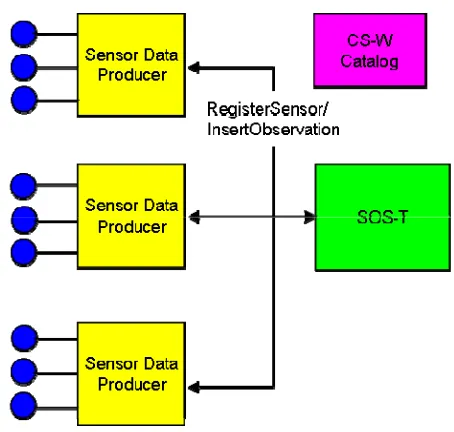
Figure 7-4 Operational Context for Sensor Data Producers
Figure 13 is a flow chart that shows the steps that can be followed by the sensor data producer. All of the steps in the flow are optional.
Figure 14 is a sequence diagram that shows how two sensor data producers interact with an SOS instance that supports the transactional profile. The first producer discovers the SOS using a CS-W catalog. The second producer has been configured to know the location of the SOS. When the producers determine that they are communicating with new sensors they register those sensors with the SOS. The producers publish sensor observations from all sensors in their control to the SOS. The diagram also shows a sensor data consumer. Consumers can request observations from the SOS at any time using the GetObservation operation. The consumer does not need to be aware of the existence of the producers and vice versa.
7.3.2 Service Discovery
Service discovery is done by using one or more OGC Catalog Service (CS-W) instances as described in section 7.2.1 above. We anticipate that sensor data publishers are likely to be more tightly bound to SOS instances than consumers and are less likely to
incorporate a catalog client. Therefore, this step will probably be skipped for most producers and the producers will instead be manually configured with the location of the SOS instance when they are deployed.
7.3.3 Sensor Registration
A producer can only publish observations to an SOS if that SOS already knows about the sensor that generated the observations. The producer can look at the capabilities
document of the SOS to determine whether the sensor is already known to the SOS. If not then the producer must register the sensor using the RegisterSensor operation.
7.3.4 Publishing of Observations
Once the producer has registered a sensor with an SOS instance it can begin publishing observations for that sensor. The SOS has the responsibility of packaging the
observations into offerings and providing them to sensor data consumers.
8 Core Operations Profile
8.1 Overview
The SOS operations follow the general pattern of other OGC Web Services (OWS) and where appropriate inherit or re-use elements defined previously in the context of OWS. Key prior specifications include OWS Common [OGC 06-121r3] which provides the basic getCapabilities response, OGC Filter Encoding Specification (FES) [OGC 04-095] which provides a syntax for ad-hoc query formulation, and Web Feature Service (WFS) [OGC 04-094] which established the standard getCapabilities/describeX/getX interaction pattern for obtaining data and framing requests.
Operations defined for a Sensor Observation Service fall into four profiles: core,
enhanced, transactional and entire. The mandatory core operations are GetCapabilities,
DescribeSensor and GetObservation and are described in this clause. The transactional
and enhanced operations are described in Clauses 9 and 10 respectively. The entire
profile of SOS implements all of these operations (core, enhanced and transactional). The implementation and use of SOS operations is specified in accordance with the HyperText Transfer Protocol (HTTP) Distributed Computing Platform (DCP). Future versions may apply to other DCPs.
8.2 GetCapabilities (mandatory)
8.2.1 Introduction
This operation allows clients to retrieve service metadata about a specific service instance. No "request" parameter is included, since the element name specifies the specific operation.
8.2.2 Request
The GetCapabilities operation request shall be as specified in Subclauses 7.2 and 7.3 of OWS Common [OGC 06-121r3]. The value of the “service” parameter shall be “SOS”. The allowed set of service metadata (or Capabilities) XML document section names and meanings shall be as specified in Tables 6 and 10 of [OGC 06-121r3], with the additions listed in Table 1 below.
Table 1 — Additional Section name values and meanings
Section name Meaning
Contents Return the contents section in service metadata document that contains information about the observation offerings.
Filter_Capabilities Return the filter capabilties section in service metadata document that contains information about the supported filters.
The “Multiplicity and use” column in Table 3 of [OGC 06-121r3] specifies the
optionality of each listed parameter in the GetCapabilities operation request. Annex B provides an example of a SOS GetCapabilities document.
8.2.3 Response
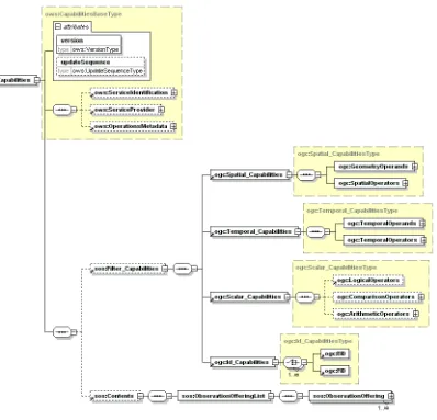
Figure 8-1. GetCapabilities Response
The portions of the GetCapabilities response document that are defined in the OWS Common specification are not modified for SOS. The subsections that follow contain only the sections of the response that are specific for the SOS; namely these are the Filter_Capabilities and the Contents section.
8.2.3.1 FilterCapabilities Section
The FilterCapabilities section is used to indicate what types of query parameters are supported by the service. These capabilities refer to the parameters of the
GetObservation operation which is the only operation that includes OGC filter-like expressions.
8.2.3.2 Contents Section
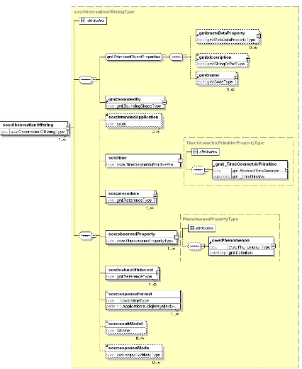
GetObservation operation. Each Observation Offering is constrained by a number of parameters described in the table below.
The Observation Offering element derives from the GML abstract feature type so it includes a GML Envelope that describes the geographic footprint of the offering. It also includes a gml:id and standard GML object metadata elements.
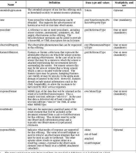
Table 2 Observation Offering Constraints
Name
a Definition Data type and values Multiplicity and
use
intendedApplication The intended category of use for this offering such as homeland security or natural resource planning
Token Optional
time Time period for which observations can be obtained. This supports the advertisement of historical as well as real-time observations.
gml:TimeGeometricPri mitivePropertyType
One (mandatory)
procedure A reference to one or more procedures, including sensor systems, instruments, simulators, etc, that supply observations in this offering. The DescribeSensor operation can be called to provide a SensorML or TML description for each system.
gml:ReferenceType One or more (mandatory)
observedProperty The observable/phenomenon that can be requested in this offering.
swe:PhenomenonProper tyType
One or more (mandatory) featureOfInterest Features or feature collections that represent the
identifiable object(s) on which the sensor systems are making observations. In the case of an in-situ sensor this may be a station to which the sensor is attached representing the environment directly surrounding the sensor. For remote sensors this may be the area or volume that is being sensed, which is not co-located with the sensor. The feature types may be generic Sampling Features (see O&M) or may be specific to the application domain of interest to the SOS. However, features should include spatial information (such as the GML boundedBy) to allow the location to be harvested by OGC service registries.
gml:ReferenceType One or more (mandatory)
responseFormat MIME type of the data that will be returned as the result of a GetObservation request. This is usually text/xml; subtype="om/0.0.0". In the case that data is delivered out of band it might be text/xml;subtype="tml/2.0" for TML or some other MIME type.
ows:MimeType One or more (mandatory)
resultModel Indicates the namespace-qualified name of the result element that will be included in the document returned from a call to GetObservation for this offering. This element must be in the om:Observation substitution group and is typically om:Observation or a specialized extension.
QName Optional
responseMode Indicates what modes of response are supported for this offering. The value of resultTemplate is used to retrieve an observation template that will later be used in calls to GetResult. The other options allow results to appear inline in a resultTag (inline), external to the observation element (out-of-band) or as a MIME attachment (attached).
a The name capitalization rules being used here are specified in Subclause 11.6.2 of [OGC 06-121r3].
8.2.4 Exceptions
allowed exception codes shall include those listed in Table 8 of Subclause 7.4.1 of [OGC 06-121r3], if the updateSequence parameter is implemented by the server.
8.2.5 Examples
See Annex B for an example of a GetCapabilities response document.
8.3 DescribeSensor (mandatory)
8.3.1 Introduction
One method of obtaining metadata that describes the characteristics of an observation procedure (sensor or sensor constellation) is to retrieve it from a catalog. However, a catalog may only contain high-level information about the observable properties, locations, contact information, etc. Due to the possibly voluminous amounts of sensor related metadata, the “describe” operations support retrieval of the highest level of detail about the platforms and sensors associated with an SOS.
DescribeSensor is designed to request detailed sensor metadata. Likewise, the response to a GetCapabilities request could provide a list of sensors associated with an SOS. Sensors are devices for the measurement of physical quantities. Both Sensor Model Language (SensorML) and Transducer Markup Language (TML) provide a detailed definition of a sensor for In-situ and Remote Sensors specification.
For the purpose of this discussion, there are two main kinds of sensor, in-situ and remote-dynamic. The DescribeSensor operation is useful for obtaining detailed information of sensor characteristics encoded in either SensorML or TML. The sensor characteristics can include lists and definitions of observables supported by the sensor. The SensorML and TML specifications detail the response model for the DescribeSensor operation.
8.3.2 Request
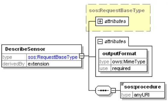
Figure 8-3 describes the syntax of the SOS DescribeSensor operation.
Table 3 Attributes of DescribeSensor Request
Name
a Definition Data type and values Multiplicity and
use
outputFormat The outputFormat attribute specifies the desired output format of the DescribeSensor operation. This can be a MimeType or QName for example. This is
text/xml;subtype=”sensorML/1.0.0” for SensorML or text/xml;subtype=”TML/1.0” for TML.
ows:MimeType Required
SensorId The sensorId parameter specifies the sensor for which the description is to be returned. This value must match the value advertised in the xlink:href attribute of a procedure element advertised in the SOS GetCapabilities response.
anyURI One (mandatory)
service Service type identifier SOS One (mandatory) version Specification version for operation Supported version of
SOS.
One (mandatory)
a The name capitalization rules being used here are specified in Subclause 11.6.2 of [OGC 06-121r3].
8.3.3 Response
A SensorML or TML document describing the sensor system.
8.3.4 Exceptions
When a SOS server encounters an error while performing a DescribeSensor operation, it shall return an exception report message as specified in clause 8 of [OGC 06-121r3].
8.3.5 Examples
8.3.5.1 Example1
This example illustrates requesting information about a specific sensor instance. The request:
<DescribeSensor xmlns="http://www.opengis.net/sos/1.0" xmlns:xsi="http://www.w3.org/2001/XMLSchema-instance"
xsi:schemaLocation="http://www.opengis.net/sos/1.0 http://schemas.opengis.net/sos/1.0.0/sosAll.xsd" service="SOS" outputFormat="text/xml;subtype="TML/1.0"" version="1.0.0">
<procedure>urn:ogc:object:Sensor:MyOrg:12349</procedure> </DescribeSensor>
<tml:transducerClass>
<tml:transmitterReceiver>receiver</tml:transmitterReceiver> <tml:insituRemote>insitu</tml:insituRemote>
. . .
</tml:system>
8.4 GetObservation (mandatory)
8.4.1 Introduction
The GetObservation operation is designed to query a service to retrieve observation data structured according to the Observation and Measurement specification. Upon receiving a GetObservation request, a SOS shall either satisfy the request or return an exception report.
8.4.2 Request
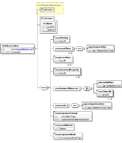
A <GetObservation> message contains one or more elements that constrain the
Table 4 Parameters of GetObservation Request
Name
a Definition Data type and values Multiplicity and
use
service Service type identifier SOS One (mandatory)
version Specification version for operation Version of SOS supported. One (mandatory)
srsName Defines the spatial reference system that should be used for any geometries that are returned in the response. This must be one of the advertised values in the offering specified in gml:srsName elements.
anyURI One (optional)
offering Specifies the offering URI advertised in the GetCapabilities document. This must match the gml:name of the offering or be constructed as a URL with a fragment identifier resolving to the offering gml:id. All of the following parameters are dependent on the selected offering.
anyURI One (mandatory)
eventTime Specifies the time period(s) for which observations are requested. This allows a client to request observations from a specific instant, multiple instances or periods of time in the past, present and future. The supported range is listed in the selected offering capabilities.
ogc:temporalOps Zero or many (Optional)
procedure The procedure parameter specifies the sensor system(s) for which observations are requested.
anyURI Zero or many (Optional) observedProperty Specifies the phenomenon for which observations
are requested.
anyURI One or many (mandatory) featureOfInterest Specifies the feature for which observations are
requested. This can either be represented by a reference to a feature ID advertised in the
capabilities document or can be a spatial constraint.
ogc:spatialOps or sos:ObjectID
Zero or one (Optional)
result Provides a place to put in OGC filter expressions based on property values. This instructs the SOS to only return observations where the result matches this expression.
ogc:comparisonOps Zero or one (Optional)
responseFormat Specifies the desired resultFormat MIME content type for transport of the results (e.g. TML, O&M native format, or MPEG stream out-of-band). The supported output formats are listed in the selected offering capabilities.
Character String type (MIME content type)
One (mandatory)
resultModel Specifies the QName of the root element of an O&M Observation or element in the appropriate substitution group. The resultModels supported by a SOS server are listed in the resultModel elements of the offerings in the service capabilities. If the requested resultModel is not supported by the SOS server, an exception message shall be returned.
QName Zero or one (Optional)
a The name capitalization rules being used here are specified in Subclause 11.6.2 of [OGC 06-121r3].
8.4.3 Response
The response to a GetObservation request is an O&M Observation, an element in the Observation substitution group, or an ObservationCollection. The SOS interface is optimized for access to observations and associated information. A detailed description of the response model and examples can be found in the Observations and Measurement encoding document5.
8.4.4 Exceptions
When a SOS server encounters an error while performing a GetObservation operation, it shall return an exception report message as specified in clause 8 of [OGC 06-121r3].
8.4.5 Examples
8.4.5.1 Example1 – Simple Request
In this example a client is requesting sensor data from a GID-3 chemical sensor that is advertised in the SOS capanbilities document. Here is the observation offering:
<ObservationOfferingList>
<ObservationOffering gml:id="offering-3">
<gml:name>urn:MyOrg:offering:3</gml:name>
<gml:srsName>EPSG:4326</gml:srsName>
<gml:boundedBy>
<gml:Envelope srsName="EPSG:4326">
<gml:lowerCorner>39.11111 -77.17695</gml:lowerCorner>
<gml:upperCorner>40.11111 -77.17695</gml:upperCorner>
</gml:Envelope>
</gml:boundedBy>
<time>
<gml:TimePeriod>
<gml:beginPosition>2005-10-18T19:54:13.000Z</gml:beginPosition>
<gml:endPosition indeterminatePosition="unknown"/>
</gml:TimePeriod>
</time>
<procedure xlink:href="urn:ogc:object:Sensor:MyOrg:12349"/>
<procedure xlink:href="urn:ogc:object:Sensor:MyOrg:12350"/>
<observedProperty>
<swe:CompositePhenomenon gml:id="AggregateChemicalPresence" dimension="2">
<gml:name>urn:ogc:def:property:MyOrg:AggregateChemicalPresence</gml:name>
<swe:component xlink:href="urn:ogc:def:property:OGC:ChemicalPresenceInAirDPM"/>
<swe:component xlink:href="urn:ogc:def:property:OGC:ChemicalPresenceInAirMS"/>
</swe:CompositePhenomenon>
</observedProperty>
<featureOfInterest xlink:href="urn:ogc:def:feature:OGC-SWE:3:transient"/>
<responseFormat>text/xml; subtype="om/1.0.0"</responseFormat>
<resultModel>om:Observation</resultModel>
<responseMode>inline</responseMode>
Here is an example of a simple GetObservation request:
<?xml version="1.0" encoding="UTF-8"?>
<sos:GetObservation xmlns:xsi="http://www.w3.org/2001/XMLSchema-instance"
xsi:schemaLocation="http://www.opengis.net/sos/1.0 http://schemas.opengis.net/sos/1.0.0/sosAll.xsd" xmlns:sos="http://www.opengis.net/sos/1.0" xmlns:om="http://www.opengis.net/om/1.0"
service="SOS" version="1.0.0" srsName="EPSG:4326"> <sos:offering>urn:MyOrg:offering:3</sos:offering>
<sos:observedProperty>urn:ogc:def:property:MyOrg:AggregateChemicalPresence</sos:observedProperty> <sos:responseFormat>text/xml; subtype="om/1.0.0"</sos:responseFormat>
<sos:resultModel>om:Observation</sos:resultModel> <sos:responseMode>inline</sos:responseMode> </sos:GetObservation>
An example of the response is as follows:
<?xml version="1.0" encoding="UTF-8"?>
<om:ObservationCollection xmlns:gml="http://www.opengis.net/gml"
xmlns:om="http://www.opengis.net/om/1.0" xmlns:swe="http://www.opengis.net/swe/1.0.1" xsi:schemaLocation="http://www.opengis.net/om/1.0 http://schemas.opengis.net/om/1.0.0/om.xsd" xmlns:xlink="http://www.w3.org/1999/xlink" xmlns:xsi="http://www.w3.org/2001/XMLSchema-instance">
<om:member>
<om:Observation>
<gml:name>urn:MyOrg:observation:1234abcde</gml:name>
<om:samplingTime>
<om:procedure xlink:href="urn:ogc:object:Sensor:MyOrg:12349"/>
<om:observedProperty xlink:href="urn:ogc:def:property:MyOrg:AggregateChemicalPresence"/>
<om:featureOfInterest xlink:href="urn:ogc:def:feature:OGC-SWE:3:transient"/>
<om:result>
<swe:Quantity definition="urn:ogc:def:property:OGC:ChemicalPresenceInAirDPM">
<swe:uom code="ppm"/>
</swe:Quantity>
</swe:field>
<swe:field name="MS">
<swe:Quantity definition="urn:ogc:def:property:OGC:ChemicalPresenceInAirMS">
<swe:uom code="ppm"/>
</swe:Quantity>
</swe:field>