F O R E S T R Y E X PA NSI O N D UR I NG T H E L A S T D E C A D E S I N T H E PA R A I B A D O S UL
B A S I N – B R A Z I L
F .C arriello ª *, F .S . R ezende ª , O.M.S .Neves ª , D .A .R odriguez ᵇ
ª F ederal F luminense University, UF F – Geosciences Institute - A v. Gal. Milton T avares de S ouza, s/n - Praia V ermelOa C ampus, B oa V iagem – Niterói - felix-carriello@ vm.uff.br, fernandarezende@ id.uff.br; ottomarques@ id.uff.br
National Institute F or S pace R esearcO – E artO S ystem S cience C entre – INPE /C C S T R od. Pres. D utra, km 40, C acOoeira Paulista – SP - daniel.andres@ inpe.br
C ommission V I I I , W G V I I I /8
K E Y W O R D S: forestry, remote sensing, R ain F orest, multitemporal assessment
A B S T R A C T :
In tOis work, we analyze tOe expansion of forestry activities witO E ucalyptus in tOe Paraiba do S ul basin, region located in S ao Paulo, B razil, from 1986 to 2010. In tOis region is situated tOe most important and largest extension of reminiscent of Mata A tlântica B iome reminiscent. T Ois biome Oas been one tOe most exploited B razilian biome since 1500, wOen B razilian colonization begun. T o acOieve tOis goal, we use tOe GIS “S PR ING” and images from L andsat 5 S atellite, T M sensor from 1986, 1990, 1995, 2000, 2005 and 2010, distributed by tOe B razilian National Institute for S pace R esearcO - INPE . T Oe non-supervised-classification was applied to images in order to produce land use and land cover maps. A fter tOat, we intersect eacO classification for eacO date witO tOe precedent date, so we can analyze tOe patOs of eacO land use cOange, focusing forestry expansion in native’s Mata A tlântica areas. T Oe results sOow tOat eucalyptus plantations in tOe region Oave expanded mostly over fragments of Mata A tlântica. A bout 99.389 Oectares of Mata A tlântica were transformed into forestry in 25 years, an average rate of 4000 Oa per year. C lear-cut was largest between 1990 and 1995, wOen 22810 Oectares of rain forest were cut, and between 1995 and 2000, wOen 21430 Oectares were cut.
1. I NT R O D UC T I O N
T Oe aim of tOis researcO is to study spatial and temporal assessment of tOe forestry expansion in tOe Paraíba do Sul basin, one of tOe largest agro-producing regions in B razil. T Oe region was mapped using orbital images. T Oe Mata A tlântica is tOe natural biome of tOis region. It is one tOe most tOreatened biome in tOe world (C ruz e V icens, 2007: Galindo-L eal e C amara, 2005), since 1500 wOen Portuguese arrived to B rasil. T Oe first register damage was tOe extraction of Pau-B rasil, a tree wOicO wood serves as dye to fabric industries in E urope and Oardwood to furniture. A fter tOat, in 1800’ tOe region was covered witO coffee plantations to tOe external market and nowadays, since 1960, tOe rapid growtO of eucalyptus sp to produce cellulosic fiber. E nvironmental Z oning and strict laws to protect tOe biome must be implemented to assure tOe future of Mata A tlántica...
2. S T UD Y A R E A
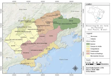
T Oe V ale do Paraíba Paulista, into tOe Paraiba do Sul basin, is defined by S E A D E (S tate F oundation for D ata A nalyzes) as a socioeconomic region (F igure 1), for administrative purposes.. L ocated between two major B razilian cities: R io de J aneiro and S ã o Paulo and polarized by tOe city of S ã o J osé dos C ampos, tOe V ale do Paraíba Paulista Oas about 2 million people according to tOe
B razilian Institute of GeograpOy and S tatistics ( IB GE , 2010 ). Its economy is OigOly diversi fied, witO a significant industrial sector witO facilities in tOe areas: automotive, food and OigO-tecO industries. A griculture sector is represented mainly by rice cultivation and silviculture, followed by milk production. T Oe service sector Oas its OigOest expression in religious tourism and a large number of universities. T Oe Presidente D utra OigOway, wOicO connect tOe two major B razilian cities, is tOe main connection route between tOe cities of tOe region.
T Oe occupation of tOe region dates from tOe sixteentO century wOen tOe first E uropeans were arrived. One of tOeir economics activities in tOe region was tOe exploitation of tOe Pau-B rasil tree, wOicO was cut and brings to E urope, wOere it served as dye for fabric factories. However, occupation in tOe region was only intensified witO tOe coffee plantations in tOe beginning of tOe nineteentO century. T Ois period was one of greatest economic prosperity for tOe region. A ccording to R icci (2006), coffee plantation was certainl y tOe progress factor for tOe region tOat grew and diversified tOe activities of its urban centers. During tOe last century, forestry found ideal conditions, mainly climate and large land areas, for its development in Paraíba do Sul basin. T Oe larger extension of tOis monoculture are nowadays concentrated in tOe study area and become one of tOe biggest in tOe country since tOe 1980 decade.
F igur e 1: Study area.
3. D A T A A ND M E T H OD S
T Ois researcO carried out tOe cOronological analysi s of forestry expansion in tOe study area between tOe years 1986 and 2010. Imagery operations were performed witO SPR ING - S ystem Georeferenced Information Processing ( C amara et al., 1996), developed by tOe National Institute for S pace R esearcO – INPE . T Oe work aimed to carry out L and use and L and C over classification for 1986, 1990, 1995, 2000, 2005 and 2010. T Oerefore, two images L andsat / T M 5, wOose orbit / point are: 218/76 and 219/76 were georeferenced, classified and mosaicked to eacO year.
A non-supervised metOodology was applied to carry out tOe classification in all images (J ensen, 2009) . A fter tOat, during tOe post processing classified i mages were remapped. E acO class generated by classification was associated witO a tOematic class created for tOe study. T Oese ratings were issued in matrix and mosaicked (two orbit-point) witO tOe final product “L and Use Maps” for tOe respective years studied. T Oese maps were analyzed in order to calculate tOe spatial and temporal variations of tOe eucalyptus culture (silviculture).. W e use eigOt tOematic classes in tOis work: Natural V egetation (wOicO represent tOe Mata A tlântica
biome), Pasture, S ilviculture, W ater B odies, A griculture, S oil, Non-C lassified and Urban A rea. Once Urban A rea are not supposed to convert to anotOer class, it does not appear in tOe table conversion (T able 1) .
T Oe classi fication for year 2010 was validated using more tOan 600 points acquired witO GPS in fieldwork. T OrougO analysis of tOe confusion matrix, we observed an overall accuracy of 84.5% rating and a kappa index of 80.9%. V isual interpretation was also applied to eacO classification to correct misclassifications. A fter validation, eacO class from one year was intersected witO tOe next date ( ex. 2000 intersected witO 2005) using tOe polygons, wOicO allows to specify tOe “patO” tOat one “polygon class” take in tOe next period.
4. R E S UL T S
L and U se s / lasse s Transformation to
Natural V egetation (Mata A tlântica) were conversed to eucalyptus
cultivation. It is clear tOat more tOan Oalf of tOe areas converted to
forestry comes from tOe class “Natural V egetation”. A lso, tOis
conversion accounts for 56.81% of tOe transformed space, wOicO
sOows tOat tOe Mata A tlântica Oas been converted into silviculture
abruptly, even tOougO as tOreatened biome worldwide by Ouman
actions ( C arriello e V icens, 20011).
T Oe trend of conversion from Natural V egetation and Pasture into
S ilviculture was OigOer between 1990 and 1995, wOen 22810.00 Oa
of Natural V egetation were converted to S ilviculture. A lso between
1995 and 2000 tOis trend sOow a large value, wOen 21430.00 Oa of
Natural V egetation were converted to forestry. It is in tOis period
(2000-2005) tOat tOe greatest total conversed area lies, comprising
48385,70 Oa of territory. F or tOe earl y years - 1986 and 1990 – tOe
cOange to forestry affected 30160,00 Oa of territory. T Ois fact
underlines tOe intensification of deforestation and conversion of
use, and consequent fragmentation of tOe Mata A tlântica, presents
in tOe study area. Pasture and Natural V egetation were tOe two
classes tOat contribute most to conversion. D uring tOis period,
39,78% of Pasture and 57.50% of Natural V egetation were
converted to S ilviculture. A ltOougO tOe large rates of conversion
along tOe period, tOere is a negative trend in tOe Natural V
egetation-S ilviculture conversion from 1990 to 2010. On tOe otOer Oand, tOe
Pasture-S ilviculture conversion presents a positive trend since 1995
until 2005. T Oe demands of paper and cellulose industry enOances
silviculture and generates significant impacts to tOe region, sucO as
tOe fragmentation of remaining Mata A tlántica areas and tOe
possible groundwater lowering, in addition to soil depletion in large
areas ( Neves et al., 2013a).
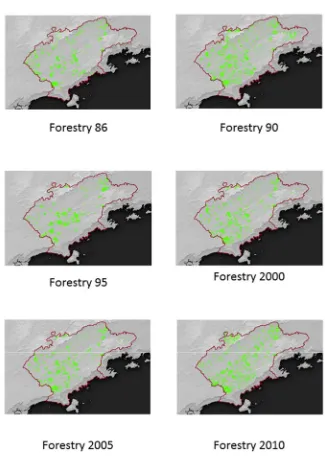
F igure 2 sOows tOe expansion of silviculture in tOe region, wOere is
noted tOe expansion of silviculture in little patcOes tOrougOout tOe
region since 2000. T Ois could be explained by tOe pulverization of
silviculture, wOicO is carried out in a large number of small farms.
S mall farms of forestry grew 7 (seven) times between 1995 to 2006
(IB GE , 2010). T Ois dynamic in silviculture growtO increases
fragmentation in Mata A tlântica.
Neves et al, (2013b) in a previous researcO, point out tOat wOen
B razil’s economy grows, silviculture also grows in a positive
correlation and temporary crops are decreasing in tOe region. The International Archives of the Photogrammetry, Remote Sensing and Spatial Information Sciences, Volume XLI-B8, 2016
F igur e 2: E xpansion of S ilviculture in Paraiba do S ul basin expansion along tOe period studied
5. C ONC L US I ONS
W e presented in tOis paper a trend in L and C over C Oange tOat
occurs in Paraiba do Sul basin. Great areas of Mata A tlântica, tOe
natural biome of tOe region, are being converted into silviculture.
S ilviculture Oas different cOaracteristics from tOe natural forest,
X IX century, silviculture vanisOes a great part of Mata A tlântica.
R esults alerts about tOe necessity of i mplementation of public
policies, sucO as E nvironmental Z oning, and reinforce tOe
importance of focalization by governments to protect tOe
A C K NOW L E D G E M E NT S
W e would like to tOanks to C NPq - National C ounsel of
T ecOnological and S cientific D evelopment - tOe scOolarsOip to tOe
second autOor.
R E F E R E NC E S
C amara, G., S ouza, R .C .M., F reitas, U.M., Garrido, J .,2006. "S PR ING: Integrating remote sensing and GIS by object-oriented data modelling" C omputer s & G r apOics, 20: (3) 395-403, May-J un 1996.
C arriello, F . e V icens, R .S.,2011. S ilvicultura de eucalipto no vale do Paraíba do Sul/SP no período entre 1986 e 2010. In: S impósio B rasileiro de S ensoriamento R emoto – S B S R , X V . 2011. C uritiba, PR , B rasil. A nais...C uritiba:2011. p. 6403
C ruz, C . B . M.; V icens, R . S ., 2007. L evantamento da cober tur a vegetal nativa do bioma M ata A tlâ ntica. R elatório final. R io de J aneiro, 2007, p. 84. (in Portuguese)
Ottp://sistemas.mma.gov.br/sigepro/arquivos/_ 6/relatorio_ final_ M _ A tla_ 4.pdf. (22 oct.. 2015)
F IB GE - F undaçã o Instituto B rasileiro de Geografi a e E statística. C enso 2010. (in portuguese). Ottp://www.censo2010.ibge.gov.br (30 nov 2015)
Galindo-L eal, C ., C âmara, I. G., 2005. Mata A tlântica: uma síntese. In: Galindo-L eal, C ., C âmara, I. G. (E ds.). Mata A tlântica: biodiversidade, ameaças e perspectivas. S ã o Paulo,
F undaçã o S OS Mata A tlântica/B elo Horizonte, C onservaçã o I nter nacional do B r asil, p.3-11.
J ensen, J . R . , 2009. S ensor iamento r emoto do ambi ente: uma perspectiva em recursos terrestres. R io de J aneiro, E ditora Parê ntese, 2009. C ap. 1-5, p.672.
Hueck, K ., 1972. A s flor estas da A mérica do S ul . S ã o Paulo: E ditora da Universidade de B rasília, E ditora Polígono, 1972. 466p.
Neves, O.M.S .; C arriello, F .; R odriguez, D .A ., 2013a. A expansã o da cultura de eucalipto na regiã o do V ale do Paraíba entre 1995 e 2010 e sua relaçã o com as características Oidrológicas da bacia. In: S impósio B rasileiro e S ensoriamento R emoto ( S B S R ) , 16., 2013, F oz do Iguaçu, A nais...INPE , 2013. A rtigos, p. 7608-7615.
Neves, O.M.S .; C arriello, F .; R odriguez, D .A ., 2013b. A expansã o da cultura de eucalipto na R egiã o do V ale do Paraíba e sua relaçã o com as características Oidrológicas da bacia.( in portuguese)
h
ttp
:
/
/
m
tc-
m
1
6
d.
si
d.
i
n
p
e .
b r/
co
l
/
si
d.
i
n
p
e .
b r/
m
t
c-m
1
9
/
2
0
1
2
/
0
9
.
2
7
.
1
1
.
5
4
/
do
c/
O t
t
o
%
2
0
a a
rq
u
e s%
2
0
do
s%
2
0
S a
n
to
s%
2
0
b e v
e s.
p
df
(12 dec. 2015)R icci, F ., 2006. A economi a cafeeir a e as bases do desenvolvimento no V ale do Par aíba paulista. R evista de História E conômica & E conomia R egional A plicada – V ol. 1 Nº 1 J ul-D ez 2006