ACCEPTANCE LETTER
No: 038/ OMAse4-038/ 2017 18 October 2017
Dear Respect Prof/ Dr/ Sir/ Madam,
Hendra Saputra, Sapto Wiratno S, Mufti Fathonah M, Didi I stardi, Ardian Budi K.A, Mir’ atul Khusna Mufida, Jasw ar Koto
Articles for the fourth OMAse Conference on Ocean, Mechanical and Aerospace -science and engineering, November 6 ~ 7, 2017, Universitas Andalas, Padang, I ndonesia :
(http:/ / isomase.org/ OMAse/ index.php)
“Development of Automatic I dentification System ( AI S) for Vessels Traffic
Monitoring in the Strait of Singapore and Batam Waterw ays”
I refer to the matter above.
I am pleased to inform you that the above-mentioned article had been accepted and I nsya Allah, All accepted papers will be selected and proposed to be published in the following proceeding and journals:
1. Proceeding of Ocean, Mechanical and Aerospace - science and engineering- ( POMAse) (ISSN: 2443-1710) indexed by ISOMAse
2. Journal of Ocean, Mechanical and Aerospace - science and engineering- ( JOMAse) (ISSN: 2354-7065, e-ISSN 2527-6085) indexed by ISOMAse
3. Journal of Subsea and Offshore - science and engineering- ( JSOse) (ISSN: 2442-6415) indexed by ISOMAse
4. Journal of Aeronautical - science and engineering- ( Jase) (ISSN: 2442-6407) indexed by ISOMAse
5. I nternational Journal of Environmental Research & Clean Energy ( I JERCE) (ISSN: 2502-3888) indexed by ISOMAse
6. Journal Mekanikal ( JM)
(ISSN: 2289-3866, e-ISSN 2289-3873) indexed by FKM, UTM
On behalf of 4th-OMAse, I wish to express our gratitude for your full cooperation and contribution in supporting our continuous effort of maintaining the publication of high quality articles in our Conference
Admin,
Fourth Conference of Ocean, Mechanical and Aerospace science and engineering (OMAse) Website: http:/ / isomase.org/ OMAse/ index.php
I NVI TATI ON LETTER
No: I L-038/ OMAse4-037/ 2017 20 October 2017
Dear Respect Prof/ Dr/ Sir/ Madam,
Hendra Saputra, Sapto Wiratno S, Mufti Fathonah M, Didi I stardi, Ardian Budi K.A, Mir’ atul Khusna Mufida, Jasw ar Koto
To Whom it May Concern
We are hereby pleased to invite you as the presenter for a manuscript :
“Development of Automatic I dentification System ( AI S) for Vessels Traffic
Monitoring in the Strait of Singapore and Batam Waterw ays”
“
Toward Enabling New Technology for the Better Future
”Dr. Adek Tasri
Chairman,
The 4thI nternational Conference of Ocean, Mechanical and Aerospace -scientists and engineers-(OMAse) Website: http:/ / isomase.org/ OMAse/ index.php
Email :
[email protected]
or
[email protected]
14.00PM-14.12PM
Rudy Purwondho Burhanuddin
14.14PM-14.26PM
Dody Eko Novianto Yohanes
14.28PM-14.40PM
Anita susilawati Niko Atmadio Heri siswanto
14.42PM-14.54PM
Fahru Rozy Sany Yohanes
14.56PM-15.08PM
Nita Yuanita Alamsyah Kurniawan Paramashanti Anasya Arsita
15.10PM-15.22PM
Novi Saldi Huayan Harahap Yohanes
15.25PM-15.37PM
Jaswar Koto
15.40PM-15.52PM
Hendra Saputra Sapto Wiratno S Mufti Fathonah M Didi Istardi Ardian Budi K.A Mir atul Khusna Mufida Jaswar Koto
Universitas Riau, indonesia
Universitas Riau, Indonesia Universitas Riau, Indonesia
Institut Teknologi Bandung Institut Teknologi Bandung Institut Teknologi Bandung Institut Teknologi Bandung Conceptual Design of Natural Coastal Erosion Protection System
Universitas Riau, Indonesia
Development of Dynamometer Based Strain Gauge With Type Four Square Plate for Cutting Force Measurement on Lathe Machine
Universitas Riau, Indonesia Room C Monday, Nov. 6 14.00AM-15.30PM
Universitas Riau, indonesia
Development of Dynamometer Based Strain Gauge With Type Four Square Plate for Cutting Force Measurement on Lathe Machine
Session Chair: Jaswar Koto
Mechanical Engineering Dept. Universitas Riau
Development of Drains made of Natural Fibers for Accelerate Consolidation in Soft Soil BINUS University Jakarta, Indonesia
Development of Dynamometer Based Strain Gauge With Type Round Rod Single for Cutting Force Measurement on Lathe Machine
PT. Ekko Hejo Bandung, Indonesia
Tool path optimation and cost analysis for manufacturing Processes of Master cylinder piston of motorcycle brake Universitas Riau, indonesia
Universitas Riau, indonesia
Hydrodynamic Analysis of COBRA Riser
Universiti Teknology Malaysia, Malaysia
Development of Automatic Identification System (AIS) for Vessels Traffic Monitoring in the Strait of Singapore and Batam Waterways
Published by International Society of Ocean, Mechanical and Aerospace Scientists and Engineers
Development of Automatic Identification System (AIS) for
Vessels Traffic Monitoring in the Strait of Singapore and Batam
Waterways
Hendra Saputra,a)*Sapto Wiratno S,a)Mufti Fathonah M,a)Didi Istardi,b)Ardian Budi K.A,b)Mir’ atul Khusna Mufida,c) Jaswar Koto,d)
a)Ship Design and Construction Technology Study Program, Department of Mechanical Engineering, Politeknik Negeri Batam, Batam,
Indonesia
b)
Department of Electrical Engineering, Politeknik Negeri Batam, Batam, Indonesia
c)
Department of Informatics Engineering, Politeknik Negeri Batam, Batam, Indonesia
d)
Faculty of Mechanical Engineering, Universiti Teknologi Malaysia (UTM), 81310, UTM Johor Bahru
*Corresponding author: [email protected]
Paper History
Received: 30-October-2017 Received in revised form: Accepted:
ABSTRACT
AIS (Automatic Identification System) is an automatic tracking system used by ships and vessel traffic service (VTS) for identifying ship information by electronically exchanging data with other vessels, coastal station, and satelite. AIS can be used to monitor vessels traffic on a strait channel by detecting a large number of vessels and collecting the ships information related to ship static, dynamic and voyage information such as MMSI number, navigation status, rate of turn (ROT), ship speed, ship position, course over ground (COG), ship heading (HDG), time stamp, RAIM flag and radio status at once. On this paper we try to develop an AIS system for vessel traffic monitoring purpose in the Strait of Malacca especially in the Strait of Singapore and Batam Waterways as one of the world’ s most congested straits used for international shipping. The method of AIS system development are divided onto 2 stage. Firstly, AIS raw data sent by ships are recorded and decoded as ships information into an application at once. Secondly, the output of AIS decode is used into web based interactive visualization application to visualize the vessels traffic. The development of AIS system has been tested by running the AIS record, decode and web visualisation and shown that the system could be applied to vessel traffic monitoring.
KEY WORDS: AIS (Automatic Identification System), Vessel Traffic Monitoring, web based interactive visualization application
NOMENCLATURE
AIS Automatic Identification System
MMSI Maritime Mobile Service Identity
IMO Internationa Maritime Organization
VTS Vessel Traffic System
1.0 INTRODUCTION
Automatic identification systems (AIS) is a system which has capability to provide information of ships and broadcast the information between ships and coastal automatically. AIS message are consist of static and dynamic information.The static information including ship name, ship MMSI, ship type ship size and current time and the dynamic information consist of ship location, speed, heading, rate of turn, destination and estimated arrival time. The Autonomously broadcasted of AIS is usefull on Vessel Traffic System (VTS) for monitoring traffic and intelligent maritime traffic manipulations such as ship tracking prediction and collision avoidance. In addition, additional radar system is used on VTS to control ship in and out at the port area.
Published by International Society of Ocean, Mechanical and Aerospace Scientists and Engineers
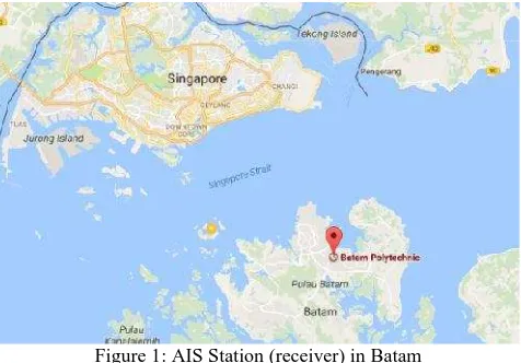
On this study, we try to develop an AIS system for vessel traffic monitoring purpose in the Strait of Malacca focused on the Strait of Singapore and Batam Waterways as one of the world’ s most congested straits used for international shipping. The AIS station on this study is located in the main building of Politeknik Negeri Batam (Batam Polytechnic).
Figure 1: AIS Station (receiver) in Batam
The AIS system developed in this study is functioning to record & decode AIS message (NMEA Message 0183) which sent by ships and visualize the ships traffic through a web based platfrom. AIS message are recorded and decoded thorugh an application at once which built using LabView programme, whereas the output of AIS decode is used into web based interactive visualization application to visualize the vessels traffic.
2.0 AUTOMATIC IDENTIFICATION SYSTEM
The Automatic Identification System (AIS) is an automatic tracking system used on ships for identifying and locating vessels by electronically exchanging data with other nearby ships, AIS base stations, and satellites. A vessel carrying AIS equipment (AIS transponder) can communicate automatically to a neighbouring vessels and nearby station by VHF radio.
The requirements for AIS are outlined in Regulation 19 of Chapter V of the IMO (International Maritime Organization) Convention for Safety of Life at Sea (SOLAS). requires AIS Class A to be fitted on board ship related to international voyages of 300 gross tonnage and above which includes all seismic vessels, cargo vessel of 500 gross tonnage and upwards not engaged on international voyages and all passenger ships irrespective of size (IMO, 1998). In May 2014, EU (European Union) fishing vessels of 15 metres and over (but less than 18 meter) are required to fit and maintain in operation an automatic identification system (AIS) . Class B equipment is used by pleasure craft, fishing boats and other vessels smaller than 300 tons, but is not mandatory.
AIS is used by marine vessels in coordination with VTS to monitor vessel location and movement primarily for traffic management, collision avoidance, and other safety applications (Perez, 2009). The information provided by AIS can be displayed on a screen and is intended to assist vessel officers and also allow authorities to track and monitor vessel movements.
AIS system has capability to handle more than 2000 data per minute and updates every two seconds (Maciej, 2010). AIS
system (transponders and receivers) use two VHF radio frequencies i.e 161.975 MHz (AIS1, or channel 87B) and 162.025 MHz (AIS2, or channel 88B). AIS is classified into 7 types: Class A, Class B, Base Station, Aids to Navigation (AtoN), Search and Rescue Transponder (SART) and AIS Transponder Specialist. Class A shipborne mobile equipment using SOTDMA (Self-Organized Time Division Multiple Access) technology that complies with IMO / SOLAS standards. Class B of AIS operate a different system to Class A transceivers. Class B operated by using Carrier Sense Time Division Multiple Access (CSTDMA) or SOTDMA. This type of AIS does not comply to IMO/SOLS standard, but comply to ISAF Cat OSR standards 1 and 2 (IMO, 1998).
The AIS class A will give information every 2 to 10 seconds while underway an every 3 minutes while anchoring. The information includes (Maciej, 2010):
a) MMSI number
b) Navigation status (as defined by COLREGS “ at anchor”,” under way using engine”, “ not under command”)
c) Rate of turn – right or left, 0 to 720 degrees per minutes d) Speed over ground – 1/10 knot resolution from 0 to 102 knots e) Position accuracy
f) Longitude and Latitude g) Course over ground h) True heading
In addition, the information will be given by AIS Class A every 6 minutes includes: g) Types of position fixing devices h) Draught of ship
i) Destinations
j) Estimated time of Arrival at destination
Class B messages have longer reporting intervals than class A when moving; the shortest reporting interval is 30 sec for equipment using carrier-sense TDMA (CSTDMA), and 5 second for equipment using self-organized TDMA (SOTDMA) moving faster than 23 knots. Static and voyage related data for class A equipment and the extended class B position report is transmitted once every 6 min in two slots (ITU, 2010)
Table 1: Class A Shipborne Mobile Equipment Reporting Intervals For Dynamic Messages
Ship’ s dynamic conditions Nominal reportinginterval
Ship at anchor or moored and not moving
faster than 3 knots 3 min Ship at anchor or moored and moving faster
than 3 knots 10 s
Published by International Society of Ocean, Mechanical and Aerospace Scientists and Engineers
2.1 AIS Message Encoding
AIS data is reported as ASCII data packets as a byte stream using the NMEA 0183 or NMEA 2000 data formats. NMEA defines
The meaning of each field is:
!AIVDM Tipe NMEA Message
1 Number of Sentences (some messages need
more then one)
1 Sentence Number (1 unless it´s a multi-sentence message) The blank is the Sequential Message ID (for multi-sentence messages)
A The AIS Channel (A or B)
14eG;... The Encoded AIS Data
0* End of Data
7D NMEA Checksum
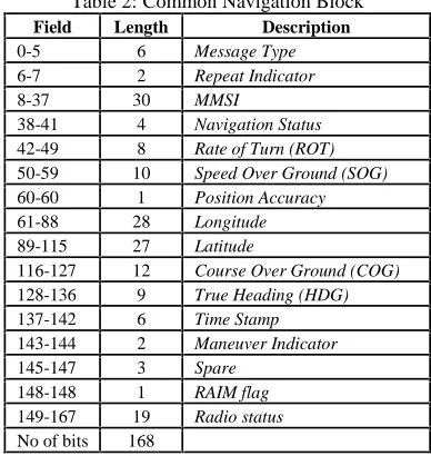
NMEA encoding of AIS message using ASCII format where each of ASCII character on the message corresponds to 6 binary bits. There are 168 total of bits, occupying one AIVDM sentence. Every sets of bit (packet bitfields) represent pieces of informasi of the AIS message by converting its to decimal. The ASCII format for AIVDM/AIVDO representations of AIS radio messages have been set by IALA Technical Clarifications on Recommendation ITU-R M.1371.
Figure 2: A fiew of AIS message (NMEA messsage) on observation structure for navigational information, its called as Common Navigation Block (CNB) (Eric, 2016)
Table 2: Common Navigation Block Field Length Description
0-5 6 Message Type
6-7 2 Repeat Indicator
8-37 30 MMSI
38-41 4 Navigation Status
42-49 8 Rate of Turn (ROT)
50-59 10 Speed Over Ground (SOG)
60-60 1 Position Accuracy
61-88 28 Longitude
89-115 27 Latitude
116-127 12 Course Over Ground (COG)
128-136 9 True Heading (HDG)
137-142 6 Time Stamp
The example of information in the AIS system as the result of decode of AIS message can be show on figure 3. The information gets from decode process are Tanggal (Date), Jam (time), Packet Type, Channel, AIS Type, Repeat Indicator, MMSI, Navigation Status, Rate of Turn, Speed Over Ground, Position Accuracy, Longitude, Latiitude, Course Over Ground, True Heading, Time Stamp, and Maneuver Indicator.
Figure 3: Example of sorts AIS information on the observation
2.2 MMSI (Maritime Mobile Service Identity) Number
Maritime Mobile Service Identities (MMSI) are nine digit numbers used by maritime digital selective calling (DSC), automatic identification systems (AIS) and certain other equipment to uniquely identify a ship or a coast radio station. MMSI are regulated and managed internationally by the International Telecommunications Union in Geneva, Switzerland. The MMSI format and use is documented in Article 19 of the ITU Radio Regulations and ITU-R Recommendation M.585-6. MMSI can be used to indetify:
1) Ship (Individual vessel or ship station) 2) Group of vessels
Published by International Society of Ocean, Mechanical and Aerospace Scientists and Engineers
4) Search and Rescue Aircraft 5) AIS Aids to Navigation (AtoN)
The structure of MMSI can be seen on the following table:
Table 3:Structure of MMSI Number
Type of MMSI number
Description Structure of the number
Individual vessel (Ship
station) M1I2D3X4X5X6X7X8X9 Group of vessels 01M2I3D4X5X6X7X8X9 Shore station or
group of shore stations 0102M3I4D5X6X7X8X9 SAR aircrafts 111213M4I5D6X7X8X9 Navigation aids 9192M3I4D5X6X7X8X9
All individual vessels (ship station) MMSIs use the format M1I2D3X4X5X6X7X8X9where in the first three digits represent the Maritime Identification Digits (MID) and X is any figure from 0 to 9. First 3 digits of MID indicates country code between 200 to 799. For instance, MID code of Indonesia is 525. On this study focused on MMSI for individual vessel (ship station) only.
3.0 DEVELOPMENT OF AIS SYSTEM IN BATAM-SINGAPORE WATERWAYS
On this paper, we try to develop an AIS system for record, decode and visualize of AIS message sent by ships passing through Strait of Singapore and Batam Waterways. The system consist of AIS receiver equipments, AIS record and decode software & web based interactive visualization application to visualize the vessels traffic. The system is installed in Politeknik Negeri Batam as AIS receiver station.
3.1 Overview of AIS Station
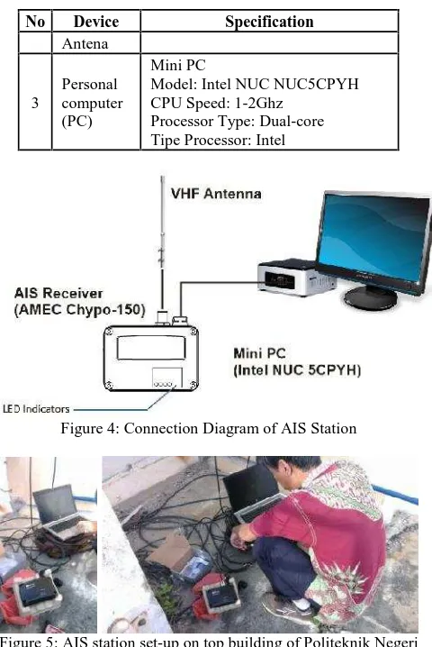
AIS receiver station in Politeknik Negeri Batam is used to record AIS data sent by ships which passing the nearby strait from station. The station consist of several hardware and device such as AIS antena, AIS receiver and personal computer (PC). The connection diagram of AIS station show in figure 4.
Table 4: AIS station devices
No Device Specification
1 AIS receiver
Brand: AMEC CYPHO-150 Applicable standards:IEC 62287-1, ITU-R M.1371, IEC 60945 and IEC 61162
Number of AIS Receivers: 2 channels
CH-1: CH 87B (161.975MHz) CH-2: CH 88B (162.025MHz) Channel Bandwidth: 25KHz Message Format: AIS Class A & B messages
Data Rate: 9,600bps / per channel Receive Sensitivity: -112 dBm @ PER ≤ 20%
2 AIS VHF antenna
No Device Specification
Antena
3
Personal computer (PC)
Mini PC
Model: Intel NUC NUC5CPYH CPU Speed: 1-2Ghz
Processor Type: Dual-core Tipe Processor: Intel
Figure 4: Connection Diagram of AIS Station
Figure 5: AIS station set-up on top building of Politeknik Negeri Batam
Figure 6: AIS station devides
3.2 Development of AIS System in Singapore Strait- Batam Waterways
Published by International Society of Ocean, Mechanical and Aerospace Scientists and Engineers
The NMEA message from AIS receiver will be simultaneously decoded and stored in in the hardisk on the PC. The NMEA Receiver will be created two different database of record & decode files and stored both databases in the different location of hardisk on the PC. The information obtained from AIS decoded was consist of Tanggal (Date), Jam (time), Packet Type, Channel, AIS Type, Repeat Indicator, MMSI, Navigation Status, Rate of Turn, Speed Over Ground, Position Accuracy, Longitude, Latiitude, Course Over Ground, True Heading, Time Stamp, and Maneuver Indicator. The AIS raw data (NMEA massage) was recorded as shown in figure 2 and decoded as shown in figure 3 in every hour.
Figure 7: The AIS record and decode
Firstly in this development of AIS system is by running the NMEA Receciver as shown in figure 7. The use of the apllication started from selecting port serial of USB connection from AIS receiver equipment. Then, selecting location for stored data recording, data decoding and data MMSI on hardisk in the PC. Data recording is database of NMEA 0183 message received from AIS receiver that will be stored on the choosen location. Data decoding is a database as result of decode AIS message that will be stored on the choosen location. Recording and decoding database will be saved on txt and csv format for every single hour. Data MMSI is a collected MMSI that filtered by every single hour of decode result.
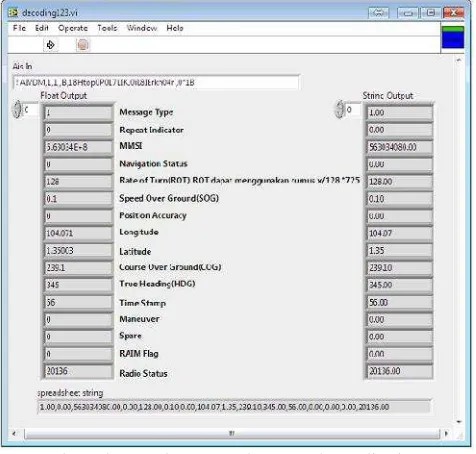
The decode process can be seen by clikcing the home button on control panel. This feature will show the information as fastly for every single message of AIS such as Message Type, Repeat Indicator, MMSI, Navigation Status, Rate of Turn (ROT), Speed Over Ground (SOG), Position Accuracy, Longitude, Latiitude, Course Over Ground (COG), True Heading, Time Stamp, Maneuver Indicator, Spare, RAIM Flag and Radio as shown in figure 8.
Secondly, the system can be used for navigation tracking or vessels tracking monitoring by visualize the longitude and latitude data which obtained from AIS decoded. This application will show the possition of ships (MMSI) on the map and show some data of the AIS such as Speed Over Ground (SOG), Course Over Ground (COG), Date and MMSI as shown in figure 9. The full detail of ships can be identified in the decode database.
Figure 8: Decode process shown on the application
(a)
(b)
Figure 9: (a) Ship distribution visualize on the web based interactive visualization application (b) Information show on the
maps by click the icon
Published by International Society of Ocean, Mechanical and Aerospace Scientists and Engineers
visualization only exhibit data synchronously, but in this research we perform dynamic representation of big Data interactively. Moreover, user be able to interact directly with the data. Interaction provided in this application are click, zoom and filter to focus on data subset as shown on figure 9.
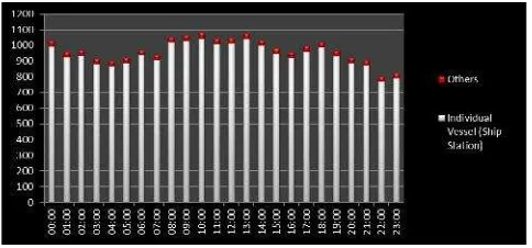
Tabel 5: Vessels traffic in the Strait of Singapore and Batam Waterways on 20 Oct 2017 at 00.00 – 23.29
No Time Total 9 08:00 1053 1018 35 3.32% 10 09:00 1066 1029 37 3.47% 11 10:00 1084 1045 39 3.60% 12 11:00 1045 1009 36 3.44% 13 12:00 1048 1011 37 3.53% 14 13:00 1077 1041 36 3.34% 15 14:00 1035 1000 35 3.38% 16 15:00 980 947 33 3.37% 17 16:00 958 922 36 3.76% 18 17:00 996 960 36 3.61% 19 18:00 1021 988 33 3.23% 20 19:00 968 933 35 3.62% 21 20:00 923 889 34 3.68% 22 21:00 906 873 33 3.64% 23 22:00 803 770 33 4.11% 24 23:00 824 791 33 4.00%
Average 975 940 35 3.59%
Table 5 shows the vessels traffic in the Strait of Singapore and Batam Waterways every hours on 20 October 2017. There are average of 975 ships passing through the staits hourly indicated by MMSI. The average MMSI hourly for individual vessels (ship station) and other MMSI were about 940 MMSI (96.41%) and 35 MMSI (3.59%) , respectively.
Figure 10: Number of ships (MMSI) hourly passed through the strait between Batam and Singapore on 20 Oct 2017
This study focused on individual vessels (ship station) only that has 9 digits of MMSI structure using format of M1I2D3X4X5X6X7X8X9as shown in table 3. The values of first 3 digits of MID that identified as individual vessels (ship station) between 200 to 799. This values also indicates country code of
the vessels.
The values excluding on the MID limits of individul vessels (ship station) was identified as others type of MMSI. This can be identified as group of vessels, shore station or group of shore stations, SAR aircrafts and navigation aids.
4.0 CONCLUSION
The AIS system has an important function in the port traffic management because the system can give an accurate possition of the target ships. The development of AIS system in this study showed that the system can be used to monitor the vessel traffic in the Stait of Singapore and Batam Waterways as one of the world’ s most congested straits used for international shipping.
The AIS system developed in this study has many advantages especially in capability for record & decode of AIS message and good visualization of the vessels traffic using web based interactive visualization application. The system has been tested by running the AIS record, decode and web visualisation and shown that the system could be applied to vessel traffic monitoring.
However, several future work need to be done to improve the capability of the system. First, need to develop a real-time visualization system for traffic monitoring. Second, the system need additional ship database such as ship principle dimension, GT, DWT and etc so that the ships data for analysis and visualization is not only MMSI number but real ship data.
REFERENCE
1. Eric S. Raymond. 2016. AIVDM/AIVDO protocol decoding. http://www.catb.org/gpsd/AIVDM.html#_ais_payload_data_ types
2. http://www.itu.int/en/ITU-R/terrestrial/fmd/Pages/mid.aspx 3. http://arundale.com/docs/ais/ais_decoder.html
4. http://leafletjs.com
5. IMO, 1998. Recommendation on performance standard for a universal shipborne Automatic Identification System (AIS), London: IMO Resolution MSC 74 (69).
6. ITU-R M.1371-4, (2010): “Technical Characteristics for a Universal Shipborne Automatic Identification System using Time Division Multiple Access in the VHF Maritime Mobile Bad”
7. Maciej, 2010. Low cost AIS receiver for coastal zone monitoring, Poland: s.n.
8. Perez, M., Chang, R., Billings, R., Kosub, T.L.,. 2009. Automatic Identification System (AIS) data use in marine vessel emission estimation. 18th Annual International Emission Inventory Conference
9. Ray C., Devogele T., Noyon V., Petit M., Fournier S., Claramunt C. GIS Technology for Maritime Traffic Systems. In: In European Research Consortium for Informatics and Mathematics News: Special Theme on Traffic Planning and Logistics, vol. 68, pages 41-42, Kuntz, P. (eds.), ERCIM EEIG, January 2007