Date: 3 May 2005
Reference number of this OpenGIS® project document: OGC 04-094
Version: 1.1.0
Category: OpenGIS® Implementation Specification
Status: Adopted Specification
Editor: Panagiotis A. Vretanos
Web Feature Service Implementation Specification
Document type:
OpenGIS® Publicly Available Implemenation Specification
Document stage:
Final
Document language:
English
worldwide license to copy and distribute this document and to modify this document and distribute copies of the modified version.
This document does not represent a commitment to implement any portion of this specification in any company’s products.
OGC’s Legal, IPR and Copyright Statements are found at http://www.opengeospatial.org/legal/ipr.htm
NOTICE
Permission to use, copy, and distribute this document in any medium for any purpose and without fee or royalty is hereby granted, provided that you include the above list of copyright holders and the entire text of this NOTICE.
We request that authorship attribution be provided in any software, documents, or other items or products that you create pursuant to the implementation of the contents of this document, or any portion thereof.
No right to create modifications or derivatives of OGC documents is granted pursuant to this license. However, if additional requirements (as documented in the Copyright FAQ at http://www.opengeospatial.org/legal/ipr_faq.htm) are satisfied, the right to create modifications or derivatives is sometimes granted by the OGC to individuals complying with those requirements.
THIS DOCUMENT IS PROVIDED "AS IS," AND COPYRIGHT HOLDERS MAKE NO REPRESENTATIONS OR
WARRANTIES, EXPRESS OR IMPLIED, INCLUDING, BUT NOT LIMITED TO, WARRANTIES OF MERCHANTABILITY, FITNESS FOR A PARTICULAR PURPOSE, NON-INFRINGEMENT, OR TITLE; THAT THE CONTENTS OF THE
DOCUMENT ARE SUITABLE FOR ANY PURPOSE; NOR THAT THE IMPLEMENTATION OF SUCH CONTENTS WILL NOT INFRINGE ANY THIRD PARTY PATENTS, COPYRIGHTS, TRADEMARKS OR OTHER RIGHTS.
COPYRIGHT HOLDERS WILL NOT BE LIABLE FOR ANY DIRECT, INDIRECT, SPECIAL OR CONSEQUENTIAL DAMAGES ARISING OUT OF ANY USE OF THE DOCUMENT OR THE PERFORMANCE OR IMPLEMENTATION OF THE CONTENTS THEREOF.
The name and trademarks of copyright holders may NOT be used in advertising or publicity pertaining to this document or its contents without specific, written prior permission. Title to copyright in this document will at all times remain with copyright holders.
RESTRICTED RIGHTS LEGEND. Use, duplication, or disclosure by government is subject to restrictions as set forth in subdivision (c)(1)(ii) of the Right in Technical Data and Computer Software Clause at DFARS 252.227.7013
Copyright © Open Geospatial Consortium, Inc (2005)
1
Contents
1 Scope...1
2 Conformance ...4
3 Normative
references...4
4
Terms and definitions ...6
5 Conventions ...7
5.1 Normative
verbs ...7
5.2 Abbreviated
terms ...7
5.3
Use of examples ...8
6
Basic service elements...8
6.1 Introduction...8
6.2
Version numbering and negotiation...8
6.2.1 Version number form ...8
6.2.2 Version
changes...8
6.2.3 Appearance in requests and in service metadata...9
6.2.4 Version number negotiation...9
6.3
General HTTP request rules...10
6.3.1 Introduction...10
6.3.2 HTTP
GET ...10
6.3.3 HTTP
POST ...11
6.3.4 HTTPS ...11
6.4
General HTTP response rules...11
6.5 Request
encoding ...12
6.5.1 Request encoding and HTTP method ...12
6.6 Namespaces...13
6.7
Simple object access protocol (SOAP) ...13
7 Common
elements...15
7.1
Feature and Element Identifiers...15
7.1.1 Globally unique identifiers (Informative)...16
7.2 Feature
state ...17
7.3 Property
names ...17
7.4 Property
references...18
7.4.1 Introduction...18
7.4.2 XPath
expressions ...18
7.5 <Native>
element...22
7.6 Filter ...23
7.7 Exception
reporting ...23
Copyright © Open Geospatial Consortium, Inc (2005)
2
7.8.1 Version
attribute ...24
7.8.2 Service
attribute ...24
7.8.3 Handle
attribute ...24
8 DescribeFeatureType
operation ...24
8.1 Introduction...24
8.2 Request...25
8.3 Response...26
8.3.1 Supporting multiple namespaces...26
8.4 Exceptions...27
8.5 Examples...27
9 GetFeature
operation...32
9.1 Introduction...32
9.2 Request...33
9.3 Response...38
9.3.1 Use of the schemaLocation attribute...39
9.4 Exceptions...40
9.5 Examples...40
10 GetGmlObject
operation...49
10.1 Introduction...49
10.2 Processing ...51
10.2.1 URI Parsing ...51
10.2.2 TopLevel ...51
10.2.3 Nested ...51
10.2.4 Redirect...52
10.3 Response...52
10.4 Exceptions...53
10.5 Examples...53
11 LockFeature
operation ...55
11.1 Introduction...55
11.2 Request...56
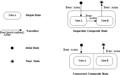
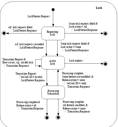
11.2.1 Schema definition...56
11.2.2 State machine notation from UML ...57
11.2.3 State machine for WFS locking ...57
11.3 Response...59
11.4 Exceptions...60
11.5 Examples...60
12 Transaction
operation ...63
12.1 Introduction...63
12.2 Request...63
12.2.1 Schema definition...63
12.2.2 Attribute descriptions...64
12.2.3 <Transaction> element ...65
12.2.4 <Insert> element ...66
Copyright © Open Geospatial Consortium, Inc (2005)
3
12.2.6 <Delete> element ...71
12.3 Response...72
12.4 Exceptions...75
12.5 Examples...75
13 GetCapabilities
operation ...79
13.1 Introduction...79
13.2 Request...79
13.3 Response...79
13.3.1 Response schema...79
13.3.2 Capabilities document ...80
13.3.3 FeatureTypeList section ...81
13.3.4 ServesGMLObjectTypeList section ...84
13.3.5 SupportsGMLObjectTypeList section...85
13.3.6 Parameters domains and Constraints...85
13.4 Exceptions...87
13.5 Examples...87
14
Keyword-value pair encoding...93
14.1 Introduction...93
14.1.1 A note about the examples ...93
14.2
Request parameter rules ...94
14.2.1 Parameter ordering and case...94
14.2.2 Parameter lists...94
14.3
Common request parameters...94
14.3.1 Version parameter ...94
14.3.2 Request parameter...95
14.3.3 Bounding box...95
14.3.4 Vendor-specific parameters ...95
14.4 Common
parameters ...96
14.5 Response...97
14.6 Exceptions...97
14.7 Operations ...97
14.7.1 Introduction...97
14.7.2 DescribeFeatureType operation ...97
14.7.2.1 Request...97
14.7.2.2 Examples...98
14.7.3 GetFeature & GetFeatureWithLock operation ...98
14.7.3.1 Request...98
14.7.3.2 Examples...101
14.7.4 GetGmlObject operation...107
14.7.4.1 Request...107
14.7.4.2 Examples...107
14.7.5 LockFeature operation ...109
14.7.5.1 Request...109
14.7.5.2 Examples...109
Copyright © Open Geospatial Consortium, Inc (2005)
4
14.7.6.1 Request...110
14.7.6.2 Examples...111
14.7.7 GetCapabilities Operation ...112
14.7.7.1 Request...112
Copyright © Open Geospatial Consortium, Inc (2005)
5
i. Preface
The Open Geospatial Consortium (OGC) has developed a member consensus that when
software vendors implement their products in compliance with open geospatial web
service interface and data encoding specifications, end-users benefit from a larger pool of
interoperable web based tools for geodata access and related geoprocessing services.
The Web Map Server products that have been developed to implement the OGC Web
Map Service Implementation Specification [1] are prime examples of such tools. The
GetCapabilities and GetMap interfaces defined in that specification give users on the web
an interoperable way to combine and view map images from different sources. And the
GetFeatureInfo interface gives those users a way to obtain attribute information about
geographic features displayed in a map with a simple mouse click.
The OGC Geography Markup Language (GML) Implementation Specification [2]
describes an encoding specification for geodata in XML that enables the storage,
transport, processing, and transformation of geographic information.
This document, the OGC Web Feature Service (WFS) Implementation Specification,
takes the next logical step of by defining interfaces for data access and manipulation
operations on geographic features using HTTP as the distributed computing platform.
Via these interfaces, a web user or service can combine, use and manage geodata
-- the feature information behind a map image -- from different sources
by invoking the following WFS operations on geographic features and elements:
•
Create a new feature instance
•
Delete a feature instance
•
Update a feature instance
•
Lock a feature instance
Copyright © Open Geospatial Consortium, Inc (2005)
6
ii. Submitting
organizations
The following companies submitted this specification to the OGC as a Request for
Comment:
CubeWerx Inc.
Edric Keighan
200 Rue Montcalm, Suite R-13
Hull, Quebec
Canada J8Y 3B5
[email protected]
Intergraph Corp.
John T. Vincent
1881 Campus Commons Drive
Reston, VA 20191
U.S.A
[email protected]
IONIC Software
Serge Margoulies
128 Avenue de l'Observatoire
B-4000 LIEGE
Belgium
[email protected]
iii.
Submission contact points
All questions regarding this submission should be directed to the Editor:
Panagiotis (Peter) A. Vretanos
CubeWerx, Inc.
200 Rue Montcalm, Suite R-13
Hull, Quebec J8Y 3B5 CANADA
+1 416 701 1985
[email protected]
Additional contributors
Rob Atkinson (Social Change Online)
[email protected]
Craig Bruce (CubeWerx)
[email protected]
Simon Cox (CSIRO) [email protected]
Paul Daisey (U.S. Census)
mailto:
[email protected]
John Davidson
[email protected]
John D. Evans (NASA)
[email protected]
Copyright © Open Geospatial Consortium, Inc (2005)
7
Ignacio Guerrero (Intergraph)
[email protected]
John Herring (Oracle Corp.)
[email protected]
Edric Keighan (CubeWerx)
[email protected]
Martin Kyle (Galdos Systems Inc.)
[email protected]
Ron Lake (Galdos Systems Inc.)
[email protected]
Jeff Lansing (Polexis)
[email protected]
Seb Lessware (Laser-Scan Ltd.)
[email protected]
Marwa Mabrouk (ESRI)
[email protected]
Serge Margoulies (Ionic)
[email protected]
Richard Martell (Galdos Systems Inc.)
[email protected]
Aleksander Milanovic
Dimitri Monie (Ionic)
[email protected]
Paul Pilkington (Laser-Scan Ltd.)
[email protected]
Keith Pomakis (CubeWerx)
[email protected]
Christopher C. Pried (Polexis)
[email protected]
Lou Reich (NASA)
[email protected]
Carl Reed (Open GIS Consortium)
[email protected]
Martin Schaefer (Cadcorp Ltd.)
[email protected]
Lacey T. Sharpe (Intergraph Corp.)
[email protected]
Raj R. Singh
Bernard Snyers (Ionic)
[email protected]
James T. Stephens (Lockheed Martin)
[email protected]
Glenn Stowe (CubeWerx)
[email protected]
Shuichi Takino (Dawn Corp.)
[email protected]
Milan Trninic (Galdos Systems Inc.)
[email protected]
John T. Vincent (Intergraph Corp.)
[email protected]
Peter Woodsford (Laser-Scan Ltd.)
[email protected]
Arliss Whitesize (BAE Systems)
[email protected]
Tim Wilson (Galdos Systems Inc.)
[email protected]
Nami Yamashita (Dawn Corp.)
[email protected]
iv. Revision
history
1.1.0
Revise document based on change proposals 02-063,03-012,03-033r4,03-052,03-082
0.0.0
Address RFC comments.
0.0.14
Reformat document in ISO format; Relate document to OGC abstract specification
(specifically Topic 12 / 19119); Include rules for property naming; Use XPath expressions
for referencing properties in complex attributes; More synchronization between WMS and
WFS with respect to keyword-value pair encoding; Add annex for conformance testing.
0.0.13
Prepare document for RFC submission; include XML-Schema encoding of WFS interfaces;
align URL-encoding with BSM
0.0.12
Add complete list of contributors; align with latest GML 2.0 draft specification; add lock
controls and versioning.
0.0.11
Correct typographical errors.
0.0.10
Server FeatureId and Filter elements into their own specification documents.
0.0.9
Review U.S.Census revisions
Copyright © Open Geospatial Consortium, Inc (2005)
8
0.0.7
Review LaserScan revisions
0.0.6
Remove "Small XML-Schema Description Language"
0.0.5
Define "Small XML-Schema Description Language"
0.0.4
Use GML2 with application defined schema using XML-Schema. Remove dependency on
featureType attribute.
0.0.3
Define GET request semantics.
0.0.2
Update <FeatureId> element to include <Scope>. Make handle attribute #IMPLIED. Add
functions on properties and literals to <Filter>.
0.0.1
First version derived from the OpenGIS Transaction Encoding Specification [3] and the
Spatial Object Transfer Format (SOTF) [4] specification.
v.
Changes to the OpenGIS Abstract Specification
No further revisions to the OGC Abstract Specification are required. The revisions
previously approved for Topic 12, "Service Architecture," including definitions of the
terms "operation", "interface" and "service" are relevant to and sufficient for this
specification. The essential operation of a web feature service, as a feature access and
management service, is described in subclause 8.3.3 of Topic 12.
vi. Future
work
Further work is desirable in the next version on the following work items.
1. Determine whether WFS should optionally offer operations beyond generic
get/lock/update operations on elements of GML version 3 types that are not
feature types, to provide specialized capabilities for such types, for example,
topological types.
2. Support an update/merge operation that allow features to be updated without
having to fetch the entire feature. For example adding vertices to a geometry
without having to specify the whole geometry in the update request.
Copyright © Open Geospatial Consortium, Inc (2005)
9
Foreword
Attention is drawn to the possibility that some of the elements of this standard may be the
subject of patent rights. Open Geospatial Consortium Inc. shall not be held responsible
for identifying any or all such patent rights. However, to date, no such rights have been
claimed or identified.
This version of the specification cancels and replaces all previous versions.
Copyright © Open Geospatial Consortium, Inc (2005)
10
Introduction
The OGC Web Map Service allows a client to overlay map images for display served
from multiple Web Map Services on the Internet. In a similar fashion, the OGC Web
Feature Service allows a client to retrieve and update geospatial data encoded in
Geography Markup Language (GML) from multiple Web Feature Services.
The requirements for a Web Feature Service are:
1. The interfaces must be defined in XML.
2. GML must be used to express features within the interface.
3. At a minimum a WFS must be able to present features using GML.
4. The predicate or filter language will be defined in XML and be derived from CQL
as defined in the OpenGIS Catalogue Interface Implementation Specification.
5. The datastore used to store geographic features should be opaque to client
applications and their only view of the data should be through the WFS interface.
6. The use of a subset of XPath expressions for referencing properties.
The purpose of this document is to describe the Web Feature Service interface, as
illustrated in figure 1.
C lient
W eb Feature Server (W FS)
O paque Feature Store
W FS R equest
Copyright © Open Geospatial Consortium, Inc (2005)
11
Figure 1 – Web feature service
Copyright © Open Geospatial Consortium, Inc (2005)
1
Web Feature Service Implementation Specification
1 Scope
This document describes the OGC Web Feature Service (WFS) operations. The WFS
operations support INSERT, UPDATE, DELETE, LOCK, QUERY and DISCOVERY
operations on geographic features using HTTP as the distributed computing platform.
In the context of this document, a transaction is a logical unit of work that is composed of
one or more data manipulation operations. Since the manner in which geographic
features are persistently stored is not addressed in this document, no transaction
semantics, such as atomic failure, are assumed to exist. It is the function of a web feature
service, in its interaction with the data storage system used to persistently store features,
to ensure that changes to data are consistent. However, the document also acknowledges
the fact that many systems do support standard concurrent transaction semantics and so
proposes optional operations that will allow a web feature service to take advantage of
such systems (e.g. relational database systems based on SQL).
Geographic features
This document adopts the same concept of a geographic feature as described in the OGC
Abstract Specification (http://www.opengeospatial.org/specs/?page=abstract) and
interpreted in the OpenGIS
®Geographic Markup Language(GML) Implementation
Specification [2]. That is to say that the state of a geographic feature is described by a set
of properties where each property can be thought of as a {name, type, value} tuple. The
name and type of each feature property is determined by its type definition. Geographic
features are those that may have at least one property that is geometry-valued. This, of
course, also implies that features can be defined with no geometric properties at all.
Processing requests
This section of the document outlines, in general terms, the protocol to be followed in
order to process web feature service requests. Processing requests would proceed as
follows:
1. A client application would request a capabilities document from the WFS. Such a
document contains a description of all the operations that the WFS supports and a
list of all feature types that it can service.
Copyright © Open Geospatial Consortium, Inc (2005)
2
3. Based on the definition of the feature type(s), the client application generates a
request as specified in this document.
4. The request is posted to a web server.
5. The WFS is invoked to read and service the request.
6. When the WFS has completed processing the request, it will generate a status
report and hand it back to the client. In the event that an error has occurred, the
status report will indicate that fact.
Note that “client application” may include Registries and other middleware, as well as
conventionally understood “end-users”.
Operations
To support transaction and query processing, the following operations are defined:
GetCapabilities
A web feature service must be able to describe its capabilities. Specifically, it must
indicate which feature types it can service and what operations are supported on each
feature type.
DescribeFeatureType
A web feature service must be able, upon request, to describe the structure of any
feature type it can service.
GetFeature
A web feature service must be able to service a request to retrieve feature instances.
In addition, the client should be able to specify which feature properties to fetch and
should be able to constrain the query spatially and non-spatially.
GetGmlObject
A web feature service may be able to service a request to retrieve element instances
by traversing XLinks that refer to their XML IDs. In addition, the client should be
able to specify whether nested XLinks embedded in returned element data should
also be retrieved.
Transaction
Copyright © Open Geospatial Consortium, Inc (2005)
3
LockFeature
A web feature service may be able to process a lock request on one or more instances
of a feature type for the duration of a transaction. This ensures that serializable
transactions are supported.
Based on the operation descriptions above, three classes of web feature services can be
defined:
Basic WFS
A basic WFS would implement the GetCapabilities, DescribeFeatureType and
GetFeature operations. This would be considered a READ-ONLY web feature
service.
XLink WFS
An XLink WFS would support all the operations of a basic web feature service and
in addition it would implement the GetGmlObject operation for local and/or remote
XLinks, and offer the option for the GetGmlObject operation to be performed during
GetFeature operations.
Transaction WFS
A transaction web feature service would support all the operations of a basic web
feature service and in addition it would implement the Transaction operation.
Optionally, a transaction WFS could implement the GetGmlObject and/or
LockFeature operations.
Copyright © Open Geospatial Consortium, Inc (2005)
4
Figure 2 – Protocol diagram
2 Conformance
Conformance with this specification shall be checked using all the relevant tests specified
in Annex D (normative). The framework, concepts, and methodology for testing, and the
criteria to be achieved to claim conformance are specified in ISO 19105: Geographic
information — Conformance and Testing.
3 Normative
references
Copyright © Open Geospatial Consortium, Inc (2005)
5
[2]
Cox S., Daisey P., Lake, R., Portele C., Whiteside A. (eds.), "OpenGIS
Implementation Specification #02-023r4: OpenGIS
Geography Markup
Language (GML) Implementation Specification, version 3.1.1", January 2005
[3]
Vretanos, Panagiotis (ed.), "OpenGIS Implementation Specification #04-095:
Filter Encoding Implementation Specification", Dec 2004
[4]
Percivall, George, ed., OpenGIS Document 02-112, “The OpenGIS Abstract
Specification, Topic 12: OpenGIS Service Architecture, Version 4.3”, 2002
[5]
Bray, Paoli, Sperberg-McQueen, eds., "Extensible Markup Language (XML) 1.0",
2nd edition, October 2000, W3C Recommendation,
http://www.w3.org/TR/2000/REC-xml
.
[6]
Beech, David, Maloney, Murry, Mendelson, Noah, Thompson, Harry S., “XML
Schema Part 1: Structures”, May 2001, W3C Recommendation,
http://www.w3c.org/TR/xmlschema-1
.
[7]
Bray, Hollander, Layman, eds., “Namespaces In XML”, January 1999, W3C
Recommendation,
http://www.w3.org/TR/2000/REC-xml-names
.
[8]
Clark, James, DeRose, Steve, “XML Path Language (XPATH), Version 1.0”,
November 1999, W3C Recommendation,
http://www.w3c.org/TR/XPath
.
[9]
Fielding et. al., "Hypertext Transfer Protocol – HTTP/1.1," IETF RFC 2616, June
1999, http://www.ietf.org/rfc/rfc2616.txt.
[10] Berners-Lee, T., Fielding, N., and Masinter, L., "Uniform Resource Identifiers
(URI): Generic Syntax", IETF RFC 2396,
http://www.ietf.org/rfc/rfc2396.txt
.
[11] National Center for Supercomputing Applications, "The Common Gateway
Interface," http://hoohoo.ncsa.uiuc.edu/cgi/.
[12] Freed, N. and Borenstein N., "Multipurpose Internet Mail Extensions (MIME) Part
One: Format of Internet Message Bodies", IETF RFC 2045, November 1996,
http://www.ietf.org/rfc/rfc2045.txt.
[13] Internet Assigned Numbers Authority,
http://www.isi.edu/in-notes/iana/assignments/media-types/
.
[14] Steve DeRose, Eve Maler, David Orchard "XML Linking Language (XLink)
Version 1.0" W3C Recommendation 27 June 2001,
http://www.w3.org/TR/xlink/
Copyright © Open Geospatial Consortium, Inc (2005)
6
[16] Rescorla et. al., "The Secure Hypertext Transfer Protocol", IETF RFC 2660,
August 1999,
http://www.ietf.org/rfc/rfc2660.txt
.
[17] DeRose et al., "XPointer xmlns() Scheme", W3C Recommendation March 2003,
http://www.w3.org/TR/xptr-xmlns/
4
Terms and definitions
For the purposes of this document, the following terms and definitions apply.
4.1
operation
specification of a transformation or query that an object may be called to execute [4]
4.2
interface
a named set of operations that characterize the behavior of an entity [4]
4.3
service
a distinct part of the functionality that is provided by an entity through interfaces [4]
4.4
service instance
an actual implementation of a service; service instance is synonymous with server
4.5
client
a software component that can invoke an operation from a server
4.6
request
an invocation by a client of an operation.
4.7
response
the result of an operation returned from a server to a client.
4.8
capabilities XML
service-level metadata describing the operations and content available at a service
instance
4.9
Copyright © Open Geospatial Consortium, Inc (2005)
7
4.10
opaque
not visible, accessible or meaningful to a client application
4.11
XLink link
an explicit relationship between resources or portions of resources [14]
4.12
XLink linking element
an XLink-conforming XML element that asserts the existence of an XLink link [14]
4.13
locator attribute (href)
the attribute that supplies the data (a URI reference) that allows an XLink application to
find a remote resource (or resource fragment) [14]
4.14
traversal
using or following an XLink link for any purpose [14]
5 Conventions
5.1 Normative verbs
In the sections labeled as normative, the key words "
must
"
,
"
must not
"
,
"
required
"
,
"
shall
"
,
"
shall not
"
,
"
should
"
,
"
should not
"
,
"
recommended
"
,
"
may
"
,
and
"
optional
"
in this document are to be interpreted as described in Internet RFC 2119 [1].
5.2 Abbreviated terms
CGI
Common Gateway Interface
DCP
Distributed Computing Platform
DTD
Document Type Definition
EPSG
European Petroleum Survey Group
GIS
Geographic Information System
GML
Geography Markup Language
HTTP
Hypertext Transfer Protocol
HTTPS
Secure Hypertext Transfer Protocol
SSL
Secure Socket Layer
IETF
Internet Engineering Task Force
MIME
Multipurpose Internet Mail Extensions
OGC
Open GIS Consortium
OWS
OGC Web Service
Copyright © Open Geospatial Consortium, Inc (2005)
8
WFS
Web Feature Service
XML
Extensible Markup Language
5.3 Use of examples
This specification makes extensive use of XML examples. They are meant to illustrate
the various aspects of a web feature service discussed in this specification. While every
effort has been made to ensure that the examples are well formed and valid, this goal was
sacrificed for the sake of clarity in many cases. For example, many examples are
formatted in a specific way to highlight a particular aspect that would render the example
invalid from the perspective of an XML validation tool. Further, most examples
reference fictitious servers and data.
Thus, this specification does not assert that any XML or keyword-value pair encoded
example, copied from this document, will necessarily execute correctly or validate using
a particular XML validation tool. Only sections marked as
normative
should be expected
to be well-formed and valid XML or XML Schema documents.
6
Basic service elements
6.1 Introduction
This section describes aspects of OGC Web Feature Service behavior that are
independent of particular operations or are common to several operations or interfaces.
6.2 Version numbering and negotiation
6.2.1
Version number form
The published specification version number contains three positive integers, separated by
decimal points, in the form "x.y.z". The numbers "y" and "z" will never exceed 99. Each
OWS specification is numbered independently.
6.2.2 Version
changes
Copyright © Open Geospatial Consortium, Inc (2005)
9
6.2.3
Appearance in requests and in service metadata
The version number appears in at least two places: in the Capabilities XML describing a
service, and in the parameter list of client requests to that service. The version number
used in a client's request of a particular service instance
must
be equal to a version
number which that instance has declared it supports (except during negotiation as
described below). A service instance may support several versions whose values clients
may discover according to the negotiation rules.
6.2.4
Version number negotiation
An OWS Client may negotiate with a Service Instance to determine a mutually agreeable
specification version. Negotiation is performed using the GetCapabilities operation [sec.
13] according to the following rules.
All Capabilities XML must include a protocol version number. In response to a
GetCapabilities request containing a version number, a web feature service
must
either
respond with output that conforms to that version of the specification,
or
negotiate a
mutually agreeable version if the requested version is not implemented on the server. If
no version number is specified in the request, the server
must
respond with the highest
version it understands and label the response accordingly.
Version number negotiation occurs as follows:
1. If the server implements the requested version number, the server
must
send that
version.
2. If the client request is for an unknown version greater than the lowest version that
the server understands, the server
must
send the highest version less than the
requested version.
3. If the client request is for a version lower than any of those known to the server,
then the server
must
send the lowest version it knows.
4. If the client does not understand the new version number sent by the server, it
may
either cease communicating with the server
or
send a new request with a
new version number that the client does understand, but which is less than that
sent by the server (if the server had responded with a lower version).
5. If the server had responded with a higher version (because the request was for a
version lower than any known to the server), and the client does not understand
the proposed higher version, then the client
may
send a new request with a
version number higher than that sent by the server.
Copyright © Open Geospatial Consortium, Inc (2005)
10
Example 1:
Server understands versions 1, 2, 4, 5 and 8. Client understands versions 1,
3, 4, 6, and 7. Client requests version 7. Server responds with version 5. Client requests
version 4. Server responds with version 4, which the client understands, and the
negotiation ends successfully.
Example 2:
Server understands versions 4, 5 and 8. Client understands version 3.
Client requests version 3. Server responds with version 4. Client does not understand
that version or any higher version, so negotiation fails and client ceases communication
with that server.
6.3
General HTTP request rules
6.3.1 Introduction
At present, the only distributed computing platform (DCP) explicitly supported by OGC
Web Services is the World Wide Web itself, or more specifically, Internet hosts
implementing the Hypertext Transfer Protocol (HTTP)[9]. Thus an HTTP Uniform
Resource Locator (URL) locates the Online Resource of each operation supported by a
service instance. The URL may be different for each operation, or the same, at the
discretion of the service provider. Each URL
must
conform to the description in [9], but
is otherwise implementation-dependent; only the parameters comprising the service
request itself are mandated by the web feature implementation service specification.
HTTP supports two request methods: GET and POST. One or both of these methods
may be defined for a particular web feature service and offered by a service instance.
The use of the Online Resource URL differs in each case.
6.3.2 HTTP
GET
An Online Resource URL intended for HTTP GET requests, is, in fact, only a URL
prefix to which additional parameters must be appended in order to construct a valid
Operation request. A URL prefix is defined as an opaque string including the protocol,
hostname, optional port number, path, a question mark '?', and,
optionally
, one or more
server-specific parameters ending in an ampersand '&'. The prefix uniquely identifies the
particular service instance. A client appends the necessary request parameters as
name/value pairs in the form "name=value&". The resulting URL
must
be valid
according to the HTTP Common Gateway Interface (CGI) standard [11], which mandates
the presence of '?' before the sequence of query parameters and the '&' between each
parameter. As with all CGI applications, the query URL is encoded [10] to protect
special characters.
The URL prefix
must
end in either a '?' (in the absence of additional server-specific
parameters) or a '&'. In practice, however, Clients
should
be prepared to add a necessary
trailing '?' or '&' before appending the Operation parameters defined in this specification
in order to construct a valid request URL.
Copyright © Open Geospatial Consortium, Inc (2005)
11
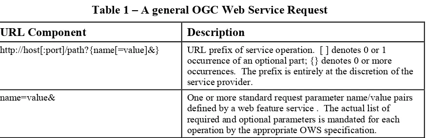
Table 1 – A general OGC Web Service Request
URL Component
Description
http://host[:port]/path?{name[=value]&}
URL prefix of service operation. [ ] denotes 0 or 1
occurrence of an optional part; {} denotes 0 or more
occurrences. The prefix is entirely at the discretion of the
service provider.
name=value&
One or more standard request parameter name/value pairs
defined by a web feature service . The actual list of
required and optional parameters is mandated for each
operation by the appropriate OWS specification.
6.3.3 HTTP
POST
An Online Resource URL intended for HTTP POST requests is a complete and valid
URL to which Clients transmit encoded requests in the body of the POST document. A
WFS
must not
require additional parameters to be appended to the URL in order to
construct a valid target for the Operation request.
6.3.4 HTTPS
In addition to or instead of offering web feature services using the HTTP protocol, a
service provider may offer web feature services using HTTPS [16]. HTTPS is HTTP
over a secure communication channel which allows encrypted information to be
transferred between machines over the World Wide Web.
The use of HTTPS does not affect the description of the requests and responses described
in this specification but may require additional actions to be taken on both the client and
the service in order to initiate the secure communication. The description of those
actions is beyond the scope of the this specification.
6.4
General HTTP response rules
Upon receiving a valid request, the service
must
send a response corresponding exactly
to the request as detailed in the appropriate specification. Only in the case of Version
Negotiation (described above) may the server offer a differing result.
Upon receiving an invalid request, the service
must
issue a Service Exception as
described in subclause 7.7.
NOTE:
As a practical matter, in the WWW environment a client should be prepared to receive either a valid result, or
nothing, or any other result. This is because the client may itself have formed a non-conforming request that
inadvertently triggered a reply by something other than a web feature service , because the Service itself may be
non-conforming.
Copyright © Open Geospatial Consortium, Inc (2005)
12
Response objects
should
be accompanied by other HTTP entity headers as appropriate
and to the extent possible. In particular, the Expires and Last-Modified headers provide
important information for caching; Content-Length may be used by clients to know when
data transmission is complete and to efficiently allocate space for results, and
Content-Encoding or Content-Transfer-Content-Encoding may be necessary for proper interpretation of the
results.
6.5 Request
encoding
This document defines two methods of encoding WFS requests. The first uses XML as
the encoding language, and is intended to be used with HTTP POST method. The second
encoding uses keyword-value pairs (KVP) to encode the various parameters of a request
and is intended to be used with HTTP GET. An example of a keyword value pair is:
"REQUEST=GetCapabilities"
where "REQUEST" is the keyword and "GetCapabilities" is the value. In both cases, the
response to a request or exception reporting must be identical.
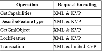
Table 2 correlates WFS operations and their encoding semantics as defined in this
specification.
Table 2 – Operation Request Encoding
Operation
Request Encoding
GetCapabilities
XML & KVP
DescribeFeatureType
XML & KVP
GetGmlObject
XML & KVP
LockFeature
XML & KVP
Transaction
XML & limited KVP
KVP
=
keyword-value
pair
This document mandates the use of GML for the XML encoding of the state of
geographic features. A complete description of this encoding can be found in document
[2].
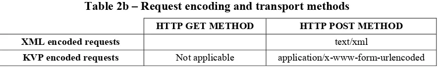
6.5.1
Request encoding and HTTP method
Copyright © Open Geospatial Consortium, Inc (2005)
13
Table 2b – Request encoding and transport methods
HTTP GET METHOD
HTTP POST METHOD
XML encoded requests
text/xml
KVP encoded requests
Not applicable
application/x-www-form-urlencoded
When using the HTTP POST method, the content type for XML encoded WFS requests
must
be set to
text/xml
.
When using the HTTP POST method, the content type for KVP encoded WFS requests
must be set to
application/x-www-form-urlencoded
and the content of the document must
be equivalent to the query string of an HTTP GET request. That is, the content must be
equivalent to the string that follows the ‘?’ character in a URL encoded GET request. Of
course, the content must be encoded [10] to protect special characters.
When using the HTTP GET method and KVP encoded WFS requests, a MIME type is
not applicable as the entire request is encoded in the URL as keyword-value pairs that
follow the ‘?’ character.
The combination of XML encoded requests and the HTTP GET method is not supported.
6.6 Namespaces
Namespaces (17) are used to discriminate XML vocabularies from one another. For the
WFS there are three normative namespace definitions, namely:
•
(
http://www.opengeospatial.net/wfs
) - for the WFS interface vocabulary
•
(
http://www.opengeospatial.net/gml
) - for the GML vocabulary
•
(
http://www.opengeospatial.net/ogc
) - for the OGC Filter vocabulary
A given WFS implementation will make use of one or more GML Application Schemas
and these schemas will use, in turn, one or more application namespaces (e.g.
http://www.someserver.com/myns). While many of the examples in this document use a
single namespace, multiple namespaces can be used, as shown in subclause 11.2.6.
6.7
Simple object access protocol (SOAP)
This subclause specifies the use of SOAP messages for communication between a web
feature service client and a web feature service using the HTTP POST method.
The Simple Object Access Protocol (SOAP) is a communication protocol for
Copyright © Open Geospatial Consortium, Inc (2005)
14
XML. This means that SOAP provides a way to communicate between applications
running on different operating systems, with different technologies and programming
languages.
A SOAP message is an ordinary XML document containing the following elements:
a) A required Envelope element that identifies the XML document as a SOAP message
b) An optional Header element that contains header information
c) A required Body element that contains call and response information
d) An optional Fault element that provides information about errors that occurred while
processing the message
All the elements above are declared in the default namespace for the SOAP envelope:
http://www.w3.org/2003/05/soap-envelope
and the default namespace for SOAP encoding and data types is:
http://www.w3.org/2003/05/soap-encoding
The SOAP specification defines a number of syntax rules. Among the most important
are:
e) A SOAP message shall be encoded using XML
f) A SOAP message shall use the SOAP Envelope namespace
g) A SOAP message shall use the SOAP Encoding namespace
h) A SOAP message shall not contain a DTD reference
i)
A SOAP message shall not contain XML Processing Instructions
The following XML fragment illustrates a skeleton SOAP message:
<?xml version="1.0"?> <soap:Envelope
xmlns:soap=http://www.w3.org/2003/05/soap-envelope
soap:encodingStyle="http://www.w3.org/2003/05/soap-encoding"> <soap:Header>
... ...
</soap:Header> <soap:Body> ... ...
Copyright © Open Geospatial Consortium, Inc (2005)
15
A client may send WFS requests to a compatible server using the body of a SOAP
envelope. The client simply encodes the WFS request as the content of the <
soap:Body
>
element in the request message.
The WFS may then response by generating a SOAP message where the response to the
client’s request is the content of the
<soap:Body>
element.
In the event the an exception is encountered while processing a WFS request encoded in
a SOAP envelope, the web feature service must generate a SOAP response message
where the content of the
<soap:Body>
element is a
<soap:Fault>
element. The
following skeleton XML fragment must be used when generating the
<soap:Body>
element in the event that a WFS encounters an exception:
<soap:Body> <soap:Fault>
<soap:faultcode>soap:Server</soap:faultode>
<soap:faultstring>A server exception was encountered.</soap:faultstring> <soap:faultactor>http://www.url_of_WFS_server.com/</soap:faultactor> <soap:detail>
<ows:ExceptionReport> …
</ows:ExpetionReport> </soap:detail>
</soap:Fault> </soap:Body>
The
<soap:faultcode>
element must have the content
soap:Server
indicating that this is a
server exception. The
<soap:faultstring>
element must have the content “Server
exception was encountered.”. This fixed string is used since the details of the exception
will be specified in the
<soap:detail>
element using an
<ows:ExceptionRecport>
element as defined in document [15].
The
<soap:detail>
element must contain an
<ows:ExceptionReport>
element detailing
the specific exception that the server encountered.
The use of the
<soap:Header>
element is not discussed in this version of this
specification.
7 Common
elements
7.1
Feature and Element Identifiers
Copyright © Open Geospatial Consortium, Inc (2005)
16
This document further assumes that if a particular WFS implementation supports the
GetGmlObject operation, each element that the WFS can operate on is uniquely
identifiable. That is to say, when a WFS implementation reports an element identifier for
an element, that identifier is unique to the server and can be user to reference the same
element (assuming it has not been deleted). Element identifiers are encoded as described
in the OpenGIS
®Filter Encoding Implementation Specification[3]. An element identifier
can be used wherever a element reference is required.
Note that the feature identifier element used in version 1.0.0 of OpenGIS
®Filter
Encoding Implementation Specification and version 1.0.0 of this specification has been
deprecated in favor of an element identifier element that is used as an identifier for both
features and elements. See clause
11 Element Identifiers
in [3] for details.
For reference purposes, the XML Schema fragment that defines identifier elements is
copied from the filter encoding specification:
<xsd:element name="_Id" type="ogc:AbstractIdType" abstract="true"/>
<xsd:element name="FeatureId" type="ogc:FeatureIdType" substitutionGroup="ogc:_Id"/> <xsd:element name="GmlObjectId"
type="ogc:GmlObjectIdType" substitutionGroup="ogc:_Id"/> <xsd:complexType name="AbstractIdType" abstract="true"/>
<xsd:complexType name="FeatureIdType"> <xsd:complexContent>
<xsd:extension base="ogc:AbstractIdType">
<xsd:attribute name="fid" type="xsd:ID" use="required"/> </xsd:extension>
</xsd:complexContent> </xsd:complexType>
<xsd:complexType name="GmlObjectIdType"> <xsd:complexContent>
<xsd:extension base="ogc:AbstractIdType"> <xsd:attribute ref="gml:id" use="required"/> </xsd:extension>
</xsd:complexContent> </xsd:complexType>
The GML Application schema that defines the features and elements served by a WFS
must require the use of feature and element identifiers that make WFS database
operations possible.
7.1.1
Globally unique identifiers (Informative)
For the purposes of a web feature service, a locally unique identifier is sufficient.
However, there is a need within OGC web services to have unique identifiers for objects
of all kinds. The approach thus far has been to reference objects using independent
scope
and
feature-id
components, where the scope is the URL of the server serving a feature
and the feature-id is the local identifier for the feature. This approach, however, may be
awkward to transport and use in other contexts, such as in a registry if one wanted to
create metadata for a single repository data instance (such as a satellite image).
Copyright © Open Geospatial Consortium, Inc (2005)
17
This string could be used as if it were fully opaque in many contexts, but it would be
more useful if it were actually a URL or URN which could be used to directly access the
object it identifies in the native format of the object. The encoding of the URL or URN
would be entirely implementation-specific. One note on the use of URNs: not many
implementations will actually be able to resolve and fetch data objects; it may be mostly
only usable as a unique identifier string.
Using a URL or URN is helpful for applications that need only simple access to the raw
objects since no interface details need to be known. This mode of access/identification is
also helpful for integration with high-level XML technologies such as RDF or XSLT, and
even for debugging purposes.
7.2 Feature
state
A GML application schema provides the definition of features served by a WFS. Clause
8 describes how a client can request an XML document containing the GML application
schema definition of one or more feature types served by a WFS. Such application
schema definitions
shall
conform to the OpenGIS Geography Markup Language(GML)
Implementation Specification, version 3.1.1 [2].
A client application uses the GML application schema definition of a feature type to refer
to feature instances of that feature type, and to refer to the names and types of all the
properties of those feature instances. The values of all properties of a feature instance
constitute the state of that feature instance. A client application references feature
instances by the name of their feature type and the names and values of feature
properties. A client application asks a transactional WFS to alter the state of a feature
through insert, update, and delete operation requests.
Likewise, a client application uses the GML application schema definitions of XML
identifiers for feature and feature property element types to refer to feature and feature
property element instances and to access them using the GetGmlObject operation.
7.3 Property
names
A web feature service refers to feature property names defined in a GML application
schema. However, since the state of a feature must be expressed in GML and thus XML,
the property names used by a web feature service must also be valid element and attribute
names as described in the Extensible Markup Language (XML) 1.0 [5] specification. In
addition, property names may be namespace qualified as described in Namespaces in
XML [7] . The following definitions are taken from clauses 2 & 3 of that document:
[4] NCName ::= (Letter | '_') (NCNameChar)* /* An XML Name, minus the ":" */
[5] NCNameChar ::= Letter | Digit | '.' | '-' | '_' | CombiningChar | Extender [6] QName ::= (Prefix ':')? LocalPart
Copyright © Open Geospatial Consortium, Inc (2005)
18
The definitions of the components Letter, Digit, CombiningChar and Extender are
defined in annex B of [5]. Finally, note that the standard (though not mandatory) GML
lexical pattern is for property names to be in lowerCamelCase [2].
Example
Examples of valid property names are:
age, Temperature, _KHz, myns:InWaterA_1M.wkbGeom
Examples of invalid property names are:
+Domain, 123_SomeName
7.4 Property references
7.4.1 Introduction
As mentioned in the introduction, GML allows geographic features to have complex or
aggregate non-geometric properties. A problem thus arises about how components of the
complex value of such properties should be referenced in the various places where
property references are required (e.g. query and filter expressions). A WFS
must
use
XPath [8] expressions, as defined in this document, for referencing the properties and
components of the value of properties of a feature encoded as XML elements or
attributes.
7.4.2 XPath
expressions
The XML Path Language [8] specification is a language for addressing parts of a XML
document, or in the case of this specification, for referencing XML elements and
attributes within the description of a feature.
This specification does not require a WFS implementation to support the full XPath
language. In order to keep the implementation entry cost as low as possible, this
specification mandates that a WFS implementation
must
support the following subset of
the XPath language:
1. A WFS implementation
must
support
abbreviated relative location
paths.
2. Relative location paths are composed of one or more
steps
separated by the path
separator ‘/’.
Copyright © Open Geospatial Consortium, Inc (2005)
19
4. Each subsequent step in the path
must
be composed of the abbreviated form of
the
child::
axis specifier and the name of the feature property encoded as the
principal node type of
element
. The abbreviated form of the
child::
axis specifier
is to simply omit the specifier from the location step.
5. Each step in the path may optionally contain a predicate composed of the
predicate delimiters ‘[‘ and ‘]’ and a number indicating which child of the context
node is to be selected. This allows feature properties that may be repeated to be
specifically referenced.
6. The final step in a path may optionally be composed of the abbreviated form of
the
attribute::
axis specifier, ‘@’, and the name of a feature property encoded as
the principal node type of
attribute
.
Example
To practically illustrate the use of XPath expressions for referencing the XML elements
and attributes within the description of a feature consider the fictitious complex feature
Person
defined by the following XML Schema document:
<?xml version="1.0" ?>
<import namespace="http://www.opengis.net/gml" schemaLocation="../gml/3.1.0/base/gml.xsd"/> <element name="Person" type="myns:PersonType" substitutionGroup="gml:_Feature"/> <complexType name="PersonType">
<complexContent>
Copyright © Open Geospatial Consortium, Inc (2005)
20
<attribute name="SIN" type="xsd:ID" use="required"/> </extension>
</complexContent> </complexType>
<complexType name="AddressPropertyType"> <sequence>
<element name="Address"
type="myns:AddressType" minOccurs="0" /> </sequence>
</complexType>
<complexType name="AddressType"> <sequence>
<element name="streetName" nillable="true"> <simpleType>
<element name="streetNumber" nillable="true"> <simpleType>
<element name="city" nillable="true"> <simpleType>
<element name="province" nillable="true"> <simpleType>
<element name="postalCode" nillable="true"> <simpleType>
<element name="country" nillable="true"> <simpleType>
Note that the property
address
has a complex value given by its type
AddressPropertyType
. An example instance of the feature
Person
might be:
<?xml version="1.0" ?> <myns:Person
Copyright © Open Geospatial Consortium, Inc (2005)
21
xmlns:myns="http://www.someserver.com/myns" xmlns:gml="http://www.opengis.net/gml" xmlns:xlink="http://www.w3.org/1999/xlink"
xmlns:xsi="http://www.w3.org/2001/XMLSchema-instance"
xsi:schemaLocation="http://www.someserver.com/myns Person.xsd"> <myns:lastName>Smith</myns:lastName>
<myns:firstName>Fred</myns:firstName> <myns:age>35</myns:age>
<myns:sex>Male</myns:sex> <myns:spouse SIN="#s444555666"/> <myns:location>
<gml:Point><gml:pos>15 15</gml:pos></gml:Point> </myns:location>
<myns:mailAddress> <myns:Address>
<myns:streetName>Main St.</myns:streetName> <myns:streetNumber>5</myns:streetNumber> <myns:city>SomeCity</myns:city>
<myns:province>Someprovince</myns:province> <myns:postalCode>X1X 1X1</myns:postalCode> <myns:country>Canada</myns:country> </myns:Address>
</myns:mailAddress>
<myns:phone>416-123-4567</myns:phone> <myns:phone>416-890-1234</myns:phone> </myns:Person>
Using XPath [8] expressions, each XML element within the description of a
Person
feature can be referenced as follows (omitting the namespace qualifiers for the sake of
clarity):
Notice that in this instance, each relative location path begins with the root element of the
feature property being referenced. This simply corresponds to the name of the feature
property. Optionally, each XML element within the description may be referenced with
the relative location path beginning with root element of the feature (i.e. the name of the
feature type). Thus the
lastName
property could be reference as
Person/lastName
, the
city
element could be referenced as
Person/mailAddress/Address/city
and so on.
Each step of the path is composed of the abbreviated
child::
axis specifier (i.e. the axis
specifier
child::
is omitted) and the name of the specified XML element within the
description, which is of node type
element
.
Copyright © Open Geospatial Consortium, Inc (2005)
22
In addition, the
SIN
1attribute on the
<Person>
and
<spouse>
elements can be referenced
using the following XPath [8] expressions:
Person/@SIN
Person/spouse/@SIN
In these cases the final step of the path contains the abbreviated axis specifier
attribute::
(i.e. @) and the node type is
attribute
(i.e.
SIN
in this case).
7.5 <Native> element
It is clear that an open interface can only support a certain common set of capabilities.
The <Native> element is intended to allow access to vendor specific capabilities of any
particular web feature server or datastore.
The <Native> element is defined by the following XML Schema fragment:
<xsd:element name="Native" type="wfs:NativeType"/> <xsd:complexType name="NativeType">
<xsd:any />
<xsd:attribute name="vendorId" type="xsd:string" use="required"/> <xsd:attribute name="safeToIgnore" type="xsd:boolean" use="required"/> </xsd:complexType>