ISSN: 2339-076X, Volume 2, Number 4 (July 2015): 383-390
DOI:10.15243/jdmlm.2015.024.383
Research Article
The characteristics and genesis of volcanic ash soils at the northern
slope toposequence of Kawi Mountain in Malang Regency
A.N. Putra
1,2*, Sudarto
1, M. L. Rayes
11Department of Soil Science, Faculty of Agriculture, University of Brawijaya Malang Jl. Veteran, Malang 65145,
Indonesia
2Soil and Water Management Postgraduate Program, Faculty of Agriculture, University of Brawijaya, Jl. Veteran,
Malang 65145, Indonesia
* corresponding author: [email protected]
Abstract:
The volcanic ash soil in Kawi Mountain is composed by the amorphous materials consist of allophane, imogolite and ferrihydrite. Results of previous study showed that the phosphate retention in all soil profiles of northern slope toposequence of Kawimountain was less than 85%, yet the phosphate retention of volcanic ash soils is usually > 85 %. This raised a question that there is a different characteristics of soil in the northern slope tosequence of the Kawi Mountain compared to the other places. This research was conducted to study soil characteristics, mineral contents, and genesis processessoccuring in soil on the northern slope toposequence of Kawi Mountain. 5 pedons between high elevation and low elevation (P1, P2, P3, P4 and P5) to identified the soil characteristics. The Al, Fe, and Si extracted by acid oxalate, natrium pyrophosphate, and dithionite citrate to calculate the amorphous mineral content. The results show that. The results showed that there is a different in terms of the thickness of the A horizon, the C organic content and the soil acidity level that mainly found in P3 and P4 profiles. The most important soil genesis processess in the formation of the volcanic ash soils were likely clay illuviation (P5), melanization and braunification (P3), littering (P1) and the reduction of andic soil properties from the upper slope (P1 profile) up to the lower slope (P5 profile).Keywords: genesis, Kawi Mountain, toposequence, volcanic ash soil
Introduction
Volcanic ash soil developed from volcanic activity materials such as tephra or phyroclastic (Shoji et al., 1993).According to Leamy et al. (1988), the earth’s land surface covered by volcanic ash soils about 124 milion hectare.Soils developed from the volcanic materials usually classified as Andisols that have an unique characteristics such as low bulk density (< 0.9 g.cm-3), high Alo+1/2 Feo> 2% and high
phosphate retention (>85%).Those characteristics are called andic soil properties.
Based on the Team Nuffic-Unibraw (1984), Kawi Mountain (2631 masl) is a stratovolcano that extend outward in small shear from the north to south and consists of a combination of andesitic rock layers, breccias, agglomerate, tuff (lava material and harden pyroclastic)and ash that overlapping on each other.Kawimountain has a
various topography that effect to the soil characteristics and genesis in the northern slope of Kawi Mountain. In per-survey stage, we found that the andic soil properties especially in phosphate retention and Si (extracted be acid oxalate) are a very low. This condition brings up a question “why the volcanic ash soil different with the same soil in another places”. This study was conducted to explain the characteristics and genesis volcanic ash soil on northern slope Kawi Mountain. This paper also examine the mineralogy contents in northern slope toposequence of Kawi Mountain in Malang Regency.
Material and Method
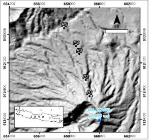
June 2013 to August 2014. The KawiMountain administratively lies in the Bendosari Village, Pujon District, Malang Regency, East Java. The coordinate of the studylocation is shown in Figure 1. Observation of soil morphological characteristicsand collection of soil samplefrom each soil horizon were conducted in the profile of 180 cm depth. The collected soil samples were analyzed in a laboratory to determine the texture, the cation exchange capacity, the base saturation,
Corganic, water retention at 1500 kPa, pH, as well as Al, Si, Fe (oxalate, pyrophosphate and dithionite) contents. Soil bulk density was determined for undisturbed soil samples heated up to1050C. The 1500kPa water retention was measured using pressure plate through the gravimetric method. The soil pH was measured using the pH electrode meter in which the prepared sample was added with water (pH H2O)
or KCl (pH KCl) with 1:1 proportion.
Figure 1. The toposequence scheme of the northern slope of KawiMountain. P1 Pedon 1, 35o, 2150 m (Typic Hapludands), P2 = Pedon 2, 35o,1610 m (Typic Hapludands), P2 = Pedon 3, 26o,1195 m (Humic Udivitrands), P4 = Pedon 4, 14o,1149 m (AndicDystrudepts), P5 = Pedon 5 =, 5o,1061 m (Ruptic-AlficDystrudepts)
The C-organic was determined using the Walkey& Black method. The cation exchange capacity (CEC) and exchangeable Ca, Mg, Na and K were extracted by using acetate ammonium pH 7. The base saturation (BS) was counted by using an equation of BS (%) = (∑Ca,Mg,Na,K) / CEC x 100 % (ISRIC,1993).
The active Al, Si, and Fe were extracted using ammonium oxalate while the bounded Al, Si and Fe were extracted with the natrium pyrophosphate (Blackmoreet al.,1987), and the free Al, Si, and Fe were extracted with the dithionite citrate (Mehra and Jackson, 1960). o phosphate retention was measured by the method of Blackmore et al. (1987).Allophane and imogolitewere counted using an equation of Sio
x7.14 (Shoji et al.,1988). Ferrihydrite was
measured using an equation of Feo x 1.7
(Mizotaandvan Reeuwijk, 1989). The crystallization degree was counted using Feo/Fed
equation (Schwertmann,1985). The formed of allophane and Al-humus were measured with Alp/Aloequation (Parfitt, 1985).
Results and Discussion
Soil morphological characteristics
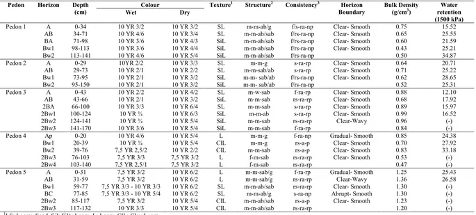
and BC horizons.In P3, P4 and P5 profiles, under the Bw/BC there is lithologic discontinuity which symbolized with 2BA/2Bw.The clearness of the horizon usually looks obvious and the boundary is flat though, in some horizons, they look clear and gradual with the wavy boundary. Soils in the P1 and P3 profiles tend to have dark colour in the upper surface and it gets brighter in the lower one. The contrast of the bright colour has chrome from 4 to 6 (Table 1).
Soils in the P2 and P5 profile have a less changing colour in both upper and lower horizons. The whole profiles tend to be dark whenever the amount of organic material is high. The intensive use of soil in the P2 location can cause the decrease of the organic material content which will affect the soil colour.The soil texture in the P1, P2 and P3 profiles is dominated by sand and silt fractions.The upper surface has sandy clay texture and it changes to be silty clay in the lower surface. The texture in upper profiles of P4 and P5 is clay and it changes to be firm clay in the lower surface. Soils in the study area have a low bulk density value, except that of the P5 profile.
When it is related to the requirements of andic soil properties (the bulk density is < 0.9 g/cm3), soils of the P1 to P4 profile have already fulfilled the requirement that is the lower the horizon, the lower is the bulk density value. The soil bulk density in the P5 profile ranges from 1.2 to 1.3 g/cm3. The bulk density values observed in this study is in the opposite of the percentage of C-organic, the deeper is the profile, the higher is the content of C-organic and the bulk density tends to be lower. The water retention ranges from 10 to 30% in all profiles and it tend to be higher in the lower horizon compared to the upper one. The physical characteristics of the soil is presented in Table 1.
Soil chemical characteristics
The pH (H2O)of soils in the study area is less than
7 which tends to be higher in the deeper soil profile. The lowest soil pH (4.76) is in the upper horizon of P5 profile (Table 2). According to Shoji and Fujiwara (1984), when the soil pH is 5 or less then the organic acid is dominated with proton donor in order to form Al-humus since it is in volcanic ash soil. Therefore, the allophane or other amorphous materials will be formed in pH 5. The frequent tendency is that the higher value of the pH, the higher is the amount of the amorphous minerals.
Althoughthe value of pH KClis relatively stable in the whole horizons, the value of the pH KCl is smaller than the pH H2O, except that in the P5
profile. The pH of NaF can only be measured
when it is in 36 cm depth from the soil surface. P1, P2 and P3 profiles have a high value (more than 9.2) and the P4 profile has less than 9.2. According toMsanya (2007), the P retention indicates the amount of the hydroxyl cluster-Al(Fe) that have reacted with NaF which in turn causes the lost of OH- from the bound. The P retention is mostly affected by the existence of amorphous minerals such as allophane and imogolite in the soil.
The cation exchange capacity (CEC) in P1 ranges from 47.13 cmol/kg in the upper horizon to 73.15 cmol/kg in the lower surface horizon. In the P2, P3 and P5 profiles, the CEC value tends to be stable that ranges from>18 cmol/kg to 35 cmol/kg. In the P4 profile, the CEC value ranges from 46 to 61 cmol/kg.The Base saturation (BS) in P1 to P4 profiles is less than 35%. The BS value in the P5 profile which is >35% in all horizons, ishigher than that of other profiles. The C-organic content in the study area is high in P1 up to P3 profiles (Table 2). The C-organic content in the P1 and P2 profiles ranges from 2.88% to 5%. In the P4 and P5 profiles, however, value of C-organic is low. Theaverage value of C-organic in P4 and P5 profiles is less than 1%.
The different elevation height of pedon location shows that the higher the place, the higher is the value of the phosphate retention. In P5 to P3 profiles, the high value of phosphate retention is no longer found. The range of value is from 10 to 60 %. However, the phosphate retention in P2 and P1 profiles can reach up to 80%. In the area of soil with volcanic ash parent material, the affinity of Al and Fe toward phosphate is high. So, it is assumed that the closer to the parent material source, the higher is the value of phosphate retention. Al+1/2 Fe extracted with the oxalate acid is one of the criteria of andic soil. If the value of Al+1/2 Fe is 2 or more, it is strongly assumed that the place has the andic soil properties. Almost all profiles and horizons have the value of Al+1/2 Fe more than 2, except for the P1 horizon1.
Soil Mineral Content
The extraction of Ammonium Oxalate and Al is around 2.03% in the upper slope and 0.2 – 6% in the lower slope. Based on Parfittet al. (1984) and Shojiet al. (1993) the concentration of theAlo in
Table 1. Physical characteristics of soils in the northern slope of Kawi Mountain
Pedon Horizon Depth (cm)
Colour Texture1 Structure2 Consistency3 Horizon Boundary
Bulk Density (g/cm3)
Water retention (1500 kPa)
Wet Dry
Pedon 1 A 0-34 10 YR 3/2 10 YR 3/2 SL m-m-ab/g f/s-ra-np Clear- Smooth 0.75 15.52
AB 34-71 10 YR 4/6 10 YR 3/4 SL m-m-ab/sab f/rs-ra-np Clear- Smooth 0.65 25.55
BA 71-98 10 YR 3/6 10 YR 4/3 SiL m-m-ab/sab f/rs-ra-np Clear- Smooth 0.60 21.59
Bw1 98-113 10 YR 3/6 10 YR 4/4 SiL m-m-ab/sab f/rs-ra-np Clear- Smooth 0.43 25.21
Bw2 113-141 10 YR 4/6 10 YR 5/4 SiL m-m-ab/sab f/rs-ra-np 0.50 34.87
Pedon 2 A 0-29 10YR 2/2 10 YR 3/3 SL m-m-g s-ra-rp Clear- Smooth 0.64 20.71
AB 29-73 10 YR 2/1 10 YR 2/2 SL m-m-sab/ab s-ra-rp Clear- Smooth 0.71 25.22
Bw1 73-95 10 YR 2/1 10 YR 3/2 SiL m-m- sab/ab f/rs-ra-np Clear- Smooth 0.62 28.65
Bw2 95-150 10 YR 2/1 10 YR 3/2 SiL m-m- sab/ab f/rs-ra-np 0.52 25.31
Pedon 3 A 0-43 10 YR 2/2 10 YR 4/2 SL m-w-sab f-ra-rp Clear- Smooth 0.88 12.10
AB 43-66 10 YR 2/1 10 YR 3/2 SiL m-m-sab rs-ra-rp Clear- Smooth 0.68 17.92
2BA 66-100 10 YR 3/3 10 YR 6/4 SL m-m-sab s-ra-rp Clear- Smooth 0.89 15.97
2Bw1 100-124 10 YR ¾ 10 YR 6/3 SiL m-m-ab s-ra-rp Clear- Smooth 0.99 16.52
2Bw2 124-141 10 YR ¾ 10 YR 5/4 SiL m-m-sab rs-ra-rp Clear-Wavy 0.96 (-)
2Bw3 141-170 10 YR 3/6 10 YR 5/4 SiL m-m-sab f-ra-rp 0.84 (-)
Pedon 4 Ap 0-20 10 YR 4/6 10 YR 5/4 L m-m-g f-ra-np Gradual- Smooth 0.85 24.38
Bw1 20-39 10 YR ¾ 10 YR 5/4 ClL m-m-g rs-a-p Clear- Smooth 0.70 27.92
Bw2 39-76 7,5 YR 2,5/2 10 YR 2/2 ClL m-m-sab rs-a-p Clear- Smooth 0.83 33.18
2Bw3 76-103 7,5 YR 3/3 7,5 YR 3/2 L f-m-sab rs-ra-rp Clear- Smooth 0.53 (-)
2Bw4 103-140 7,5 YR 2,5/1 7,5 YR 3/2 L f-m-sab rs-ra-rp 0.47 (-)
Pedon 5 A 0-31 7,5 YR 3/2 10 YR 6/2 L m-m-sab/g f-ra-rp Gradual- Smooth 1.25 25.43
AB 31-59 7,5 YR 3/2 10 YR 6/2 L m-m-sab/g rs-ra-rp Clear-Wavy 1.36 26.58
Bw1 59-77 7,5 YR 3/3 - 10 YR 3/3 10 YR 6/2 SL m-m-ab/sab rs-ra-rp Clear- Smooth 1.30 (-)
BC 77-85 7,5 YR 3/3 - 10 YR 5/4 10 YR 6/2 SL m-m-ab/g s-ra-np Abrupt- Smooth 1.30 (-)
2Bw2 85-117 7,5 YR 3/2 10 YR 5/4 ClL m-m-ab/sab rs-a-p Clear- Smooth 1.23 (-)
2Bw3 117-132 10 YR 3/3 10 YR 5/4 ClL m-m-ab/sab rs-ra-rp 1.20 (-)
1
LS: Loamy Sand, Sil: Silty Loam, L: Loam, ClL: Clay Loam
2Size (f: fine, m: medium, c: coarse),Development (w: weak, m: medium, h: hard), Type (g: granular, sab:sub angular blocky, ab: angular blocky) 3
f: friable, rs: rather shady, s: shady, ra: rather adhesive,a: adhesive, rp: rather plastic, p: plastic, np: no plastic
Table 2. Chemical characteristics of soils in the northern slopeof Kawi Mountain
Pedon Horizon pH CationExcgange
Capacity (cmol/kg)
Base Saturation (%)
C-organic (%)
H2O KCl
Pedon 1 A 5.93 5.28 47.13 23.02 3.54
AB 6.24 5.68 57.47 27.68 3.28
BA 6.17 5.67 59.09 11.43 2.95
Bw1 6.24 5.49 73.15 9.03 3.78
Bw2 6.25 5.56 57.18 13.64 2.88
Pedon 2 A 6.01 5.3 36.50 24.15 3.84
AB 6.20 5.47 38.30 19.27 4.68
Bw1 6.13 5.43 47.23 15.21 5.03
Bw2 6.11 5.46 59.57 16.27 5.41
Pedon 3 A 5.98 4.87 34.82 23.05 3.86
AB 5.91 5.04 32.53 28.65 4.10
2BA 6.18 5.44 19.24 34.76 1.65
2Bw1 6.07 5.07 35.88 19.98 1.38
2Bw2 6.16 5.14 31.62 25.52 1.55
2Bw3 6.14 5.28 18.58 33.47 0.55
Pedon 4 Ap 5.38 4.08 56.38 18.42 1.34
Bw1 5.84 4.79 46.95 14.69 0.79
Bw2 5.94 5.15 62.03 19.68 2.59
2Bw3 5.87 4.69 61.77 17.53 1.11
2Bw4 6.09 5.18 58.80 20.61 1.58
Pedon 5 A 4.76 5.32 30.81 35.17 0.94
AB 4.92 5.55 25.23 41.23 0.54
Bw1 4.98 5.85 24.60 41.18 0.21
BC 4.98 5.85 24.60 41.18 0.21
2Bw2 5.00 5.97 24.89 41.03 0.14
2Bw3 5.03 6.19 30.64 40.30 0.29
This condition describes that the value of Fe in the further research is higher compare to the range given by Parfit and Shoji. The Si value that was extracted with the ammonium oxalate is around 0.03 up to 0.1 % in the upper slope and 0.1% to 0.2 % in the lower slope. Those numbers are considered as a small number if they are compared to what has found by Tsai (2010) that is 0.82 – 1.4% in the upper slope and 0.1 – 0.6% in the lower slope. The extraction result of Pyrophosphate to Al in the upper slope is 0.02% while in the lower slope is 0.04%. The value of Pyrophosphate extraction with Fe in the upper slope is 0.3 up to 0.4% and 0.4 to 0.8% in the lower one. The Dithionite extraction value with Al is around 0.86 to 1.35 % in the upper slope and 0.2 to 0.6 % in the lower slope.
Based on Schwertmann (1985), the ratio of Feo and Fed can be used as the indicator of the
crystallization degree of the iron oxide age and it also can be reflected as the soil development degree of volcanic ash soils (Malucelliet al.,1999).Kleberet al. (2004) says that the volcanic ash soil (mainly Andisol) has the Feoand
Fedratio more than 0.75. In P1 Feo/Fedmore than
0.75 between 0 until 98 cm depth and decreasing
in the lower horizon. Pedon P2 and P3 have no different condition with P1 Feoand Fedratio. The
Feoand Fedratio shows that crystallization degree
in P4 and P5 is higher than P1, P2 and P3 soil profiles. It means that the soil in P4 and P5 have more develops than the soil in the upper slope (P1, P2 and P3).The result of Feo/Fed shown in
Table 4.
All Pedon in each horizon has Alo/Alpvalue
less than 0.5. This condition can be reflected that no Al-humus bound was found in the soil. The reason of inexistence the Al-humus complexescaused the pH H2O more than 5 and it
Table 3. The analysis result on extraction of Al, Si and Fe using ammonium oxalate, pyrophosphate and Bw1 0,03 4,23 1,64 0,02 0,38 0,56 1,35 3,05 0,54 5,05 3,00 Pedon 2 A 0,01 2,14 0,96 0,02 0,48 0,27 0,81 0,70 1,37 2,62 1,70 AB 0,01 3,25 0,87 0,02 0,42 0,28 0,79 1,05 0,83 3,69 1,55 Bw1 0,01 3,95 1,26 0,02 0,45 0,35 0,93 1,63 0,77 4,58 2,21 Bw2 0,01 4,25 1,57 0,02 0,47 0,42 1,03 2,07 0,76 5,04 2,74 Pedon 3 A 0,45 3,41 1,32 0,02 0,29 0,26 0,48 0,94 1,40 4,07 5,46 AB 0,08 3,88 1,50 0,03 0,44 0,32 0,53 1,02 1,47 4,63 3,12 Pedon 4 Ap 0,10 1,16 2,64 0,04 0,40 0,48 0,44 3,01 0,88 2,48 5,20 Bw1 0,18 0,82 1,84 0,01 0,59 0,51 0,36 3,12 0,59 1,74 4,41 Bw2 0,25 1,56 1,97 0,01 0,83 0,72 0,62 2,81 0,70 2,55 5,13 Pedon 5 A 0,14 6,00 1,00 0,01 0,45 0,33 0,26 1,63 0,61 6,50 2,70 AB 0,14 0,52 0,92 0,01 0,45 0,33 0,20 1,52 0,61 0,98 2,56
Soil Genesis
Andisols formed in pedon P1, P2, and P3 affected by amorphous materials. Typic Hapludands that discovered in P1 have an umbric epipedon and cambic endopedon. Overall horizons has low bulk density less than 0.9 g.cm-3,P retention more than
25 % and Al+1/2 Fe more than 0.4 %. Pedon P2 classified as HumicUdivitrandswith water retention in 1500kPaless than 15% in the top of the horizon.
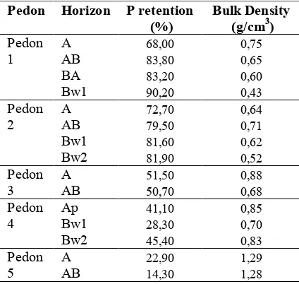
Table 4. The P retention and bulk density of the soil profiles in the research location
Pedon Horizon P retention (%)
Bulk Density (g/cm3)
Pedon A 68,00 0,75
1 AB 83,80 0,65
BA 83,20 0,60
Bw1 90,20 0,43
Pedon A 72,70 0,64
2 AB 79,50 0,71
Bw1 81,60 0,62
Bw2 81,90 0,52
Pedon A 51,50 0,88
3 AB 50,70 0,68
Pedon Ap 41,10 0,85
4 Bw1 28,30 0,70
Bw2 45,40 0,83
Pedon A 22,90 1,29
5 AB 14,30 1,28
P4 and P5 are classified as the Inceptisolthat have a low characteristics of andic soil properties. The low count of andic soil properties linier with decreasing the elevation. The lowest P retention value was found in P5 or lower elevation (P retention requirement was more than 25 % in coarse particle and 85 % in smooth particle) and the highest bulk density was in P5 to (the requirement of andic soil properties was less than 0.9 g/cm-3.
Braunification is one of the soil genesis process that connected with the forming of soil colour. Based on Chen et al. (1999), Braunification is a process of the brown colour formation in the soil as the secondary result of the Fe Oxide formation and it can be proved by the value of Fed and Feo.Braunification mostly
the upper horizon changes into light brown which makes the clear boundary.
Littering is piles of fresh organic matter that only exist in P1 soil profile (the highest pedon) which is 9 cm in thickness. While in the other profiles, there is only small amount of littering accumulation. The melanization process is signed by the dark colour changing in the soil that caused by the mix between the organic matter/ humus with the mineral deposit in horizon O and A. Besides Umbric and Molic, the result of melanization process is the forming of Melanic.Melanic has high content of Corganicwhich
also have the andic soil properties in it. By seeing the value and chrome colour level (in the moistwas<2 ) in P2 and P3 profile, the research result shows that there is a possibility of the melanic is formed. Though, that particular melanic characteristics cannot be fulfilled since the Corganicvalue is less than 4%.
Soil is classified in to TypicHapludands in P1 and P2 profile, HumicUdivitrands in P3 profile, AndicDystrudepts in P4 profile and Ruptic-AlficDystrudepts in P5 profile. HumicUdivitrands is characterized by the value of the water retention is 12.10% in A horizon (< 15%). Inceptisol in P5 profile is stated as the most developed inceptisol since the andic soil properties in this profile is the weakest one, which showed by the value of the bulk density is more than 1 g.cm-3 and the phosphate retention was very low. Ruptic-AlficDystrudepts is described as soil that in one of its horizon has base saturation less than 35% and there is a small amount of solid illuviation in its B horizon. This condition also indicates that the farther from the parent material source, the soil will more highly develop.
Conclusion
Soil developed under volcanic ash materials on the northern slope toposequence of Kawi Mount areclassified asAndisols(in the upper part) and Inceptisols (in the lower part). The different characteristics that is observable in each profile is the thickness of the A horizon, the soil Corganicand
the soil acid. The allophane and imogolite condition that commonly getting higher whenever the deeper the soil depth is found to have an opposite result, while the ferrihydrite is getting higher when the depth of the soil is deeper. The Fe degree of crystallization in the research location is getting higher in the lower depth of the location.In P5 profile which has already contained solid illuviation whileP3 profile have the melanization process that happens in 43 cm depth and alsobraunification under this horizon. P1
profile there is littering of organic matter 9 cm in thickness and the andic soil characteristics does exist.
Acknowledgements
The first author wishes to thank staffs of Bendosari village, Pujon, Malang Regency for their kind help in collecting soil samples. Special thanks are also due to DGHE (Directorate General of Higher Education) for scholarship grant under the frame of MP-Fast Track Programme.
References
Arifin, M. 1994. Pedogenesis Andisol Berbahan Induk Abu Vulkan Andesit dan Basalt pada Beberapa ZonaA groklimat di Daerah Perkebunan The Jawa Barat. Disertasi Doktor. Institut Pertanian Bogor. Blackmore, L. C. 1987. Soil Bureau Laboratory
Methods for Chemical Analysis of Soil. New Zealand Soil Bureau. Soil rep. 10 A. DSIRO. New Zealand.
Chen, Z.S., Tsou, T.C.,Asio, V.B. and. Tsai, C.C. 2001. Genesis of Inceptisols on a volcanic landscape in Taiwan.Soil Science166: 255-266.
Kleber, M., Mikutta, C. andJahn, R. 2004. Andosols in Germany - pedogenesis and properties.Catena56: 67- 83.
Leamy, M. L., Clayden, B.,Parfitt, R.L., Kinloch, D.I. and Childs, C.W. 1988. Final Proposal of the International Committee of the Classification of Andisol (ICOMAND). New Zealand Soil Bureau. DSIR, Lower Hutt.
Malucelli, F.,Terribile, F. and Colombo, C. 1999. Mineralogy, micromorphology and chemical analysis of Andosols on the Island of Sao Miguel (Azores).Geoderma :88:73-98.
Mehra, O. P. and Jackson, M.L. 1960. Iron oxide removal from soils and clays by a dithionite citrate system buffered with sodium bicarbonate. Clays
and Clay Minerals7: 713 – 727.
Mizota, C. and van Reeuwijk, L. P. 1989. Clay Mineralogy and Chemistry of Soils formed inVolcanic Material in Diverse Climatic Regions. Soil monograph 2, ISRIC, Wageningen, The Netherlands.
Msanya, B.M,. Otsuka, H., Araki, S. and Fojitake. N. 2007. Characterization of Volcanic Ash Soils in South Western Tanzania: morphology, physicochemical properties and classification.
African Study Monographs, Supplement34: 39-55.
Parfitt, R. L. and Hemni, T. 1982. Comparison of an oxalate extraction method and an infrared method for determining alofan on soil clays. Soil Science
and Plant Nutrition28:183-190.
Parfitt, R.L., Saigusa, M. and Cowie, J.D. 1984. Alofan and haloisit formation in volcanic ash bed under different moisture condition. Soil Science138: 360-364.
volcanic ash beds in New Zealand. Soil Science 139: 149–155.
Schwertmann,U. 1985. The Effect of Pedogenic Environments on Iron Oxide Minerals. In B.A.Stewart (ed.) Advances in Soil Science.1. Springer Verlag, New York.p.171–200.
Schwertmann,, U. and Taylor, R.M. 1989. Iron oxides. In Dixon, JB (Ed) Minerals in Soil Environment, 2nd ed. Soil Science Society American Journal.,USA. P: 379-438.
Shoji, S. and Fujiwara, Y. 1984. Active aluminum and iron in the humus horisons of Andosols from northeastern Japan: their forms, properties, and significance in clay weathering. Soil Science137: 216–226.
Shoji, S., Nanzyo, M. and Dahlgren, R.A. 1993. Volcanic Ash Soil: Genesis, Properties and Utilization. Elsevier Science Publishers B.V. Amsterdam, The Netherlands.
Tan, K. H. 1982. Principles of Soil Chemistry. Marcel Dekker Inc. New York. P:30