Developing accurate decision making skill by a crisis simulation on
volcanic eruption
Tjipto Prastowo*
Center for Earth Science Studies, Department of Physics, The State University of Surabaya, Surabaya 60231, Indonesia
Abstract
Due to its geographical location and geological condition, Indonesia has many active volcanoes, hence potential to volcanic eruption. Efforts for minimizing impacts and reducing risks have been made, but much has not yet been achieved. Public awareness is the cornerstone of fundamental approaches aimed at reducing vulnerabilities to geophysical hazards. Concerns with national program for disaster risk reduction call for tertiary institutions to include disaster preparedness into university science curricula. This research examines the relevance of three eruption indicators: earthquake frequency, ground deformation rate, and SO2 emission flux to eruption probability. A number of 53 science students were then involved in volcanic simulation using an online software called Eruption. The aim of this study is therefore to develop students’ emergency decision making skills for evacuation processes based on feedback given by three instruments. For all indicators, it was found that the eruption probability increases with increasing volcanic activities, where the volcanic earthquake frequency is the dominant indicator among others and that lives saved are spread over 35-60% of total population with an operational cost spent is in the range 16-36% of total funds available.
Keywords earthquake frequency, eruption, ground deformation rate, SO2 emission flux
1.
Introduction
The ability of higher-order thinking skills (HOTS) in response to learning environments introduced in class is critical to science education. In this context, computer-enhanced instruction has been increasingly popular to be integrated into science learning to promote the development of these skills (Mayer & Moreno, 2002). In particular, effective computer-based learning exercises in a classroom setting can be used, with a given topic of discussion for problem solving, to improve decision making skill (Taylor et al., 1997; Renshaw et al., 1998). In line with this, hazard-mitigation teaching (Bladh, 1990) relevant to program for disaster risk reduction seeks for an effective method of promoting earth sciences to university students. One way of doing this is to provide these students with an online volcanic crisis simulation (Harp & Sweeney, 2002; Barclay et al., 2011) using a free software called
Eruption. The crisis here is relevant to Indonesia (BRI & NGIPS, 2007), due to its geographical location and geological condition, where Indonesia has a series of active volcanoes and hence potential to volcanic eruption. Efforts for minimizing impacts and reducing risks have been
SWUP made, but much has not yet been achieved. Thus, the study regarding public including students awareness of disaster-related science remains important.
Problems in teaching hazard science in universities may arise from a method chosen; whether a conventional method of teaching or a modern one with the help of computer for ease of teaching is used. In this study, the Eruption is utilised to examine the relevance of eruption indicators to the probability of eruption based on a varying level of each indicator simulated in the form of text and number-based data and measured by three different monitoring instruments to evacuate people living near the volcano. The volcanic simulation can also be used to determine specific problem regarding which indicator that plays the dominant role in the volcanic eruption. The aim of this study is therefore to develop students’ accurate decision making skill as part of learning processes in hazard mitigation study. The decision made is aimed at achieving maximum lives saved and minimum operational costs. Thus, this study is beneficial to improve students’s awareness of natural science and hazard management related to geophysical hazards frequently occurred in Indonesia, in particular volcanic eruption.
2.
Materials and methods
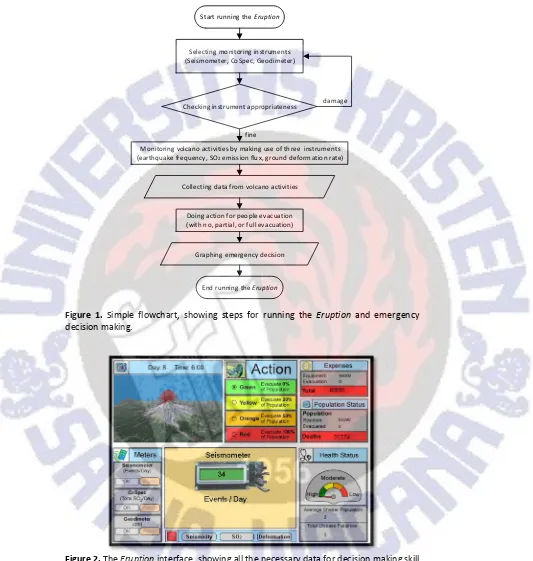
Integrated efforts for maximizing public awareness and minimizing disaster risks in terms of hazard mitigation study were better to include academics and students in both designing and implementing research in relevant fields, as reported in some countries (BRI and NGIPS, 2007). One promising breakthrough believed to provide positive contributions to disaster risk reduction program was to promote disaster science teaching in schools and universities via relevant media (Bladh, 1990; Smith et al. 1995; Hodder, 1999). Using the Eruption, an online simulation, available at http://www.dartmouth.edu/~earthsci/eruption for a practically improved method of HOTS, Harp and Sweeney (2002) and Barclay et al. (2011) discussed the results of web-based learning in the volcanic eruption simulation, where the focus of such learning was on rapid and accurate emergency decision making skill of each research respondent based on ‘field information’ given. The Eruption provides a useful exercise on the expected skill used to evaluate hazardous levels associated with volcanic eruption. The exercise relies on measurable physical quantities given by three independent eruption parameters in the form of text and numerical data format on screen that describe the eruption probability. The decision taken corresponds directly to evacuation, where action of no, partial, or full evacuation of people living nearby a volcano is necessary to do for a minimum risk. Figure 1 provides a simple flowchart, showing detailed steps to perform volcanic simulation using the Eruption.
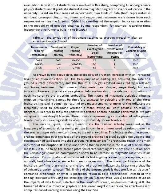
The Eruption provides important information about eruption indicator readings given by a Seismometer for earthquake frequency monitoring, a Geodimeter for ground deformation rate monitoring, and then a Cospec for SO2 emission flux monitoring. Low levels
Figure 1. Simple flowchart, showing steps for running the Eruption and emergency decision making.
Figure 2. The Eruption interface, showing all the necessary data for decision making skill techniques.
3.
Results and discussion
Two important elements considered in this study were instrument responses in terms of scaled-readings and respondent responses in terms of emergency decision making for
Start running the Eruption
Selecting monitoring instruments (Seismometer, CoSpec, Geodimeter)
Monitoring volcano activities by making use of three instruments (earthquake frequency, SO2 emission flux, ground deformation rate)
Checking instrument appropriateness
Doing action for people evacuation (with no, partial, or full evacuation)
Graphing emergency decision
End running the Eruption fine
damage
SWUP evacuation. A total of 53 students were involved in this study, comprising 45 undergraduate physics students and 8 graduate students from magister program of science education in the university. Based on their series of experiments, two kinds of data (both represented in numbers) corresponding to instrument and respondent responses were drawn from each respondent running the Eruption. Table 1 lists readings of the eruption indicators in relation to the probability of eruption obtained by one respondent, for example, regarding three independent instruments built in the Eruption.
Table 1. The correlation of instrument readings to eruption probability after an
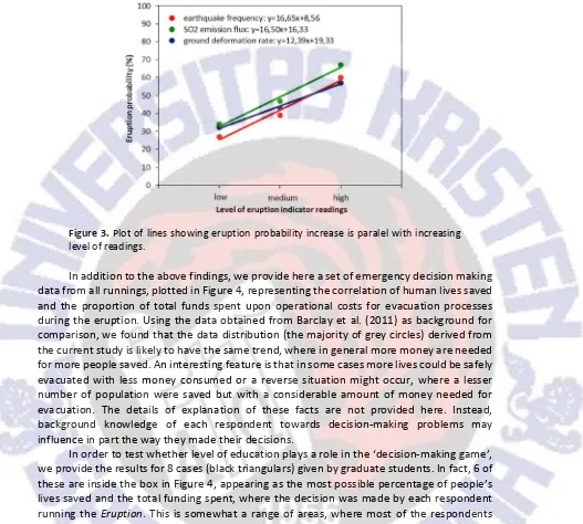
As shown by the above data, the probability of eruption increases with an increasing level of eruption indicators, i.e., the frequency of an earthquake occurred, the rate of a ground surface deformated, and the flux of a SO2 gas emitted measured by a relevant
monitoring instrument: Seismometer, Geodimeter, and Cospec, respectively, for each indicator. However, the data above give no information about the relative contributions of each indicator to the eruption probability. The nature of magmatic activities affecting eruption mechanisms cannot be therefore assessed by selecting only one of the three indicators. Instead, a combined result of two measurements, or more, of the indicators are frequently used to determine whether a state, owing to likely possible eruption, is dangerous. In order to show the relative importance of each indicator performance, we plot in Figure 3 three straight lines in different colors, representing a correlation of cathegorized levels of indicator readings and the eruption probability for each indicator.
Figure 3. Plot of lines showing eruption probability increase is paralel with increasing level of readings.
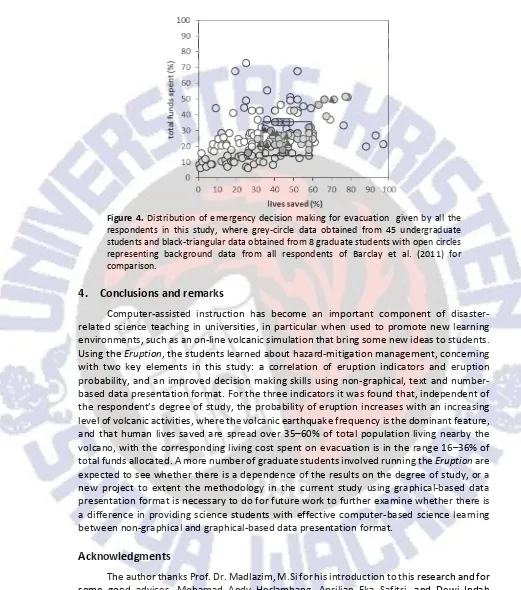
In addition to the above findings, we provide here a set of emergency decision making data from all runnings, plotted in Figure 4, representing the correlation of human lives saved and the proportion of total funds spent upon operational costs for evacuation processes during the eruption. Using the data obtained from Barclay et al. (2011) as background for comparison, we found that the data distribution (the majority of grey circles) derived from the current study is likely to have the same trend, where in general more money are needed for more people saved. An interesting feature is that in some cases more lives could be safely evacuated with less money consumed or a reverse situation might occur, where a lesser number of population were saved but with a considerable amount of money needed for evacuation. The details of explanation of these facts are not provided here. Instead, background knowledge of each respondent towards decision-making problems may influence in part the way they made their decisions.
SWUP
Figure 4. Distribution of emergency decision making for evacuation given by all the
respondents in this study, where grey-circle data obtained from 45 undergraduate students and black-triangular data obtained from 8 graduate students with open circles representing background data from all respondents of Barclay et al. (2011) for comparison.
4.
Conclusions and remarks
Computer-assisted instruction has become an important component of disaster-related science teaching in universities, in particular when used to promote new learning environments, such as an on-line volcanic simulation that bring some new ideas to students.
Using the Eruption, the students learned about hazard-mitigation management, concerning
with two key elements in this study: a correlation of eruption indicators and eruption probability, and an improved decision making skills using non-graphical, text and number-based data presentation format. For the three indicators it was found that, independent of the respondent’s degree of study, the probability of eruption increases with an increasing level of volcanic activities, where the volcanic earthquake frequency is the dominant feature, and that human lives saved are spread over 35–60% of total population living nearby the volcano, with the corresponding living cost spent on evacuation is in the range 16–36% of
total funds allocated. A more number of graduate students involved running the Eruption are
expected to see whether there is a dependence of the results on the degree of study, or a new project to extent the methodology in the current study using graphical-based data presentation format is necessary to do for future work to further examine whether there is a difference in providing science students with effective computer-based science learning between non-graphical and graphical-based data presentation format.
Acknowledgments
References
Mayer, R.E., & Moreno, R. (2002). Aids to computer-based multimedia learning. Learning and Instruction, 12, 107–119.
Taylor, H.A., Renshaw, C.E., & Jensen, M.D. (1997). Effects of computer-based role playing on decision making skills. Journal of Educational Computing Research, 17, 147–164.
Renshaw, C.E., Taylor, H.A., & Reynolds, C.H. (1998). Impact of computer-assisted instruction in hydrogeology on critical thinking skills. Journal of Geoscience Education, 46, 274–279.
Bladh, K.L. (1990). Teaching hazard-mitigation education in a liberal-art college. Journal of Geoscience Education, 38, 339–342.
Harpp, K.S., & Sweeney, W.J. (2002) Simulating a volcanic crisis in the classroom. Journal of Geoscience Education, 50, 410–418.
Barclay, E.J., Renshaw, C.E., Taylor, H.A., & Bilge, A.R. (2011). Improving decision making skill using an online volcanic crisis simulation: Impact of data presentation format. Journal of Geoscience Education, 59, 85–92.
Building Research Institute (BRI) & National Graduate Institute for Policy Studies (NGIPS) (2007). Disaster Education. Section for Disaster Reduction UNESCO, Paris.
Smith, D.L., Hoersch, A.L., & Gordon, P.R. (1995). Problem-based learning in the undergraduate geology classroom. Journal of Geoscience Education, 43, 385–390.