Implementation of Decision Support System for Integrated Coastal
Zone Management of Sustainable Mariculture Development
Industry in Indonesia
Hermawan, S.1
Abstract: Indonesia has abundant and potential coastal resources for future development of mariculture industry activities. However, complex problem is found in the land and coastal zone utilization, among others: coastal environment degradation, resources depletion, conflict and overlapping utilization of marine area. New perspective of Decision Support System (DSS) for integrated coastal zone management (ICZM) can be used to solve this complexity with respect to the results of high resolution of hydrodynamic and wave numerical model, water quality, and ICZM. The aim of this paper is to determine the suitable site for the implementation of sustainable future development of mariculture in Galang Island, Riau Province, Indonesia. A suitability map of geographic information system based on ICZM is indicated by sixteen thematic maps. Implementations of the comprehensive ICZM of DSS criteria prove that Galang Island has a bright potential of Grouper mariculture development industry by sustainable suitable area of about 12,940 hectares.
Keywords: Decision support system; integrated coastal zone management; sustainable mariculture.
Introduction
The global fishery production declines because of commercial fish harvesting at or above their maxi-mum sustainable yield, while, demand for fish and fishery products increase steadily in recent years. Mariculture is one of the most important protein food supplier and fastest growing food production sectors to the world population [1-4]. However, its development has focus very minimal on environ-mental sustainable practice with respect to coastal environment degradation, overlapping and conflict-ing utilization, laws regardconflict-ing marine, and coastal management [5].
Many countries have adopted Integrated Coastal Zone Management (ICZM) and implied it, surpri-singly the result does not meet their expectation especially in developing countries [6]. The growth of mariculture in the coastal zones causes a lot of pressure over the fragile coastal environment, which supports various key economic and subsistence activities [2].
1 Civil Engineering Department, Petra Christian University, Surabaya, INDONESIA.
Email: [email protected]
Note: Discussion is expected before November, 1st 2016, and will be
published in the “Civil Engineering Dimension” volume 19, number
1, March 2017.
Received 04 February 2016; revised 31 August 2016; accepted 02 September 2016.
Therefore, the implementation of the integrated management of coastal and open seas in the future will become an added-value product to the revenue of all maritime industries and also international agreements for the sustainable exploitation of the sea resources [6]. Then, as the largest archipelagic state in the world, it is important for Indonesia to establish ICZM for sustainable mariculture develop-ment.
The Decision Support System (DSS) methodology is an approach to structuring and supporting the ICZM decision-making process through the screening of data, the assessing of stakeholders, and the scanning of development strategies [7]. The use of DSS for ICZM has been developed to meet the flexibility of dynamic environment. This method can be used to overcome the complexity of ICZM which are required to determine the integration of bio-geo-physical environment as well as policy decisions. It is a computerized system capable to support and assist decision maker in ICZM [8], and also can be used to solve multiple discipline issues and has the ability to integrate multi-disciplinary environment [6]. Several authors discuss the development of planning tools for the management of mariculture, using Geographic Information Systems (GIS) [9-12].
needed toward the sustainability of mariculture, particularly in terms of more effective farm plan-ning, site selection, and management that carefully consider the carrying capacity of the environment and the needs of the other users of the coastal resources [2].
Material and Method
New perspective of DSS for ICZM can be used to solve the complexity with respect to the results of high resolution of hydrodynamic and wave numeri-cal model of 5 years simulation selected (2005-2009), water quality, and ICZM. In this paper, the imple-mentation of ICZM in System for the Sustainable Management of Floating Net Cage Grouper Cultures (SYSMAR) DSS was applied to identify the suitable sites for sustainable future development of maricul-ture in Galang Island, Riau Province, Indonesia. The SYSMAR DSS is integrated in a graphical user interface and the system has been successfully applied to a large number of coastal sites in Indonesia [3,4].
Identification of Suitable Sites
Sources of Data
The required data for the application of the DSS is obtained from several sources. Bathymetric data along near shore areas in Indonesia is usually obtained from nautical charts issued by the Badan Koordinasi Survey danPemetaanNasional (National Coordinating Agency for Survey and Mapping). General Bathymetric Chart of the Oceans (GEBCO) data, issued by the British Oceanographic Data Centre, U.K. [13] is adopted to provide information in deeper areas. The data is provided on a horizontal grid with a resolution of 30 arc-second intervals or about 0.5 nautical miles. For tidal variations and wind characteristics for diving, the numerical models are extracted from Egbert and Erofeeva [14] and National Centers for Environmental Prediction and
the National Center for Atmospheric Research (NCEP/NCAR) reanalysis database [15]. Water quality information is obtained from Coral Reef Information and Training Centers (CRITC, LIPI) [16], Pusat Penelitian and Pengembangan Geologi Kelautan (Research Development Centre of Ocean Geology, RDCOG) [17] and Schlitzer [18].
Problems resulting from conflicts of coastal area utilization and adverse natural environmental conditions are also accounted for in the selection of suitable sites. For this purpose, geographic data is collected to identify the most relevant problems in the coastal zone. In this case, specific uses are assigned to identify a coastal area and the associated potential risks. The initial analysis is based on regional planning data of National Development Planning Agency [19] and Sahalo [20]. On the basis of this analysis, the most relevant information for the conditions under investigation is selected. Due to the fact that information on current velocities and waves are seldom available, models for the simula-tion of flow and waves are usually set up for the coastal areas under investigation.
Analytical Framework
Whole data gained are assimilated in a Geographic Information System (GIS) and processed by an analytical framework proposed by Windupranata [21]. As a result, an overview of the degree of capability and suitability criteria for development of floating net cages (FNC) Grouper culture within the entire chosen domain is provided. The adopted GIS approaches rely on a simple overlay of processes. In this way, the areas considered suitable for sup-porting the use of the proposed resource are identi-fied with suitability factors weighted equally across categories. Thematic grids are prepared using GIS tools and reclassified according to the suitable crite-ria (see Figure 1). Three categories representing unsuitable (=0), allowable (=1), and optimal (=2) conditions are considered.
An example of a reclassification process of bathy-metric information is presented in Figure 1a. The figure illustrates the approach adopted in the classification of the bathymetry on the basis of minimum water depth. Once a grid cell is unsuited due to the fact that it is outside the recommended surrounding conditions affected, along with the farmed stock to reduce the potential risks of floating net cage (FNC) Grouper farms. The selection of sites is based on spatial information of an array of parameters due to the suitability (biophysical para-meters) and feasibility analysis (extrinsic aspects: coastal usage/ICZM). As can be seen in Table 1, in
order to determine the suitability of a site, a number of parameters and criteria affecting FNC Grouper culture for South East Asian farm practice were selected [23-26]. Table 1 lists the parameters adop-ted with the associaadop-ted qualifications allowing for a ranking regarding the conditions of a predefined culture type and species.
Galang Island (0o45’N 104o15.1E)
Regarding Act no. 25 in 2002 [27], Riau Archipelago has become the 32nd Indonesian Province. Galang Island is located in this province and covers an area of about 80 km2. It is located in the Southern part of the Malacca Strait, in the Southern part of the South China Sea, and about 40 km Southeast of Kota Batam. The island is currently under the adminis-tration of Galang Kota Batam District, Batam City, Riau Archipelago Province. The sub district Galang comprises 120 islands covering the total area of 14,610 km2. Only 36 islands are populated. About 14,600 inhabitants live in Galang Island [20].
Table 1.Site Selection of Groupers Grown in Floating Net Cages [4].
Description Parameters Indicators Units Unsuitable Allowable Optimal
Physical Process
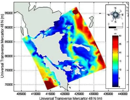
Figure 2.Galang Island-Local Model Bathymetry
The condition of the bathymetry with respect to Indonesian Nautical Chart number 42 [28] can be seen in Figure 2. Generally, the sea water in the vicinity of Galang is categorized as a shallow area which is surrounded by coral reef. The depth of seawater in the vicinity Galang Island is mostly less than 15 m, only the Eastern area has a depth of about 25 m (see Figure 2).
According to the Coral Reef Information and Train-ing Centers (CRITC) [16] dissolved oxygen concen-trations are in the range of 6.9 – 8.2 mg/l. Salinity ranges from 32–35 psu. The sea water temperatures vary between 26 - 29oC. Characteristic pH values of 8.20–8.80 were observed in the area. The transpa-rency of seawater by measuring the depth ranges from 2.5 to 10 m. The average current velocities range from 0.2 to 0.4 m/s. In 2005, the Research Development Centre of Ocean Geology [17] revealed that nitrate concentrations were in the range 0.002 - 0.078 mg/l, and nitrites were between 0.002 and 0.431 mg/l. Characteristic turbidity values are about 8 mg/l. The rainy season in the region is longer than the dry season, which affects the climate, in particular air temperature and precipitation [16]. In 2005, the minimum and maximum air pressures were respectively equal to 100.5 kPa and 101.8 kPa. The average humidity ranges from 77 to 86%. Maximum wind speed is reported in the order of 13.4 m/s. The amount of rainfall during 2005 was 2,171 mm within 220 days rainy days. Windupranata [21] revealed that significant wave heights in the vicinity of Galang Island are in the range 0.6–1 m. The mixed semidiurnal tides have a tidal range varying between 0.6 and 2.8 m [29]. Field measurements carried out at several locations in the Galang sub-district from May to November 2009 by the CRITC, Indonesian Institute of Science (LIPI), resulted in recorded tide heights of around 1.2–1.5 m. According to CRITC [16], dissolved oxygen concentrations are in the range of 6.9–8.2 mg/l. Salinity ranges from 32–
35 psu. The sea water temperatures vary between 26-29oC. Characteristic pH values of 8.20–8.80 were observed in the area. Water clarity which was indicated with secchi depth ranges from 2.5 to 10 m. The average current velocities range from 0.2 to 0.4 m/s. The Research Development Centre of Ocean Geology [17] revealed that nitrate concentrations were in the range 0.002-0.078 mg/l, and nitrites were between 0.002 and 0.431 mg/l. Characteristic turbi-dity values are about 8 mg/l. On the basis of the information available, the water quality in the surrounding area of Galang Island is acceptable for FNC Grouper culture development. The attention should be paid to oxygen concentrations.
Data from the National Development Planning Agency (NDPA) [19] was collected to assess the ICZM criteria near Galang Island. Information was gathered of villages, tourism, semi intensive hatche-ries or mariculture areas, traffic lanes, coastal usage for strategic areas, as well as environmentally protected areas (coral reef region). The sea covers 96% of the total area of the territory of Sub District Galang. This makes it very favorable for developing mariculture activities, including hatchery cultiva-tion, and Snapper fish farming, seaweed cultivation and floating net cage (FNC) farms cultivating Grou-pers. However, current development is quite slow.
Results
The performance of an implementation of the ICZM in DSS will be presented. Through the use of a geographic information system (GIS) as a spatial planning tool, this DSS is able to assist in site selection as has been shown by a number of previous authors [3, 4, 12, 21].
A comprehensive site suitability and capability map which integrates all of the selected criteria was edited using 32 parameters identified in Table 1. In order to assess the relative impacts of each category of parameters (e.g. physical, chemical, and ICZM) on the DSS result, the suitability maps of the three applied categories are presented in Figure 3. Loca-tions are selected based on the suitability and sustainability consideration of each weighted para-meter. Thus, the inputs and results of the DSS are designed to investigate, estimate, and correlate the information from different sources available in the database. When using DSS, data input or analysis types are selected by the user through the interface that controls the type of analysis to be made by the model components of the DSS.
a. Suitability Map in the Vicinity of the Galang Island based on Minimum Water Depth
b. Suitability Map in the Vicinity of the Galang Island based on Maximum Water Depth
c. Suitability Map in the Vicinity of the Galang Island Based on Flushing
d. Suitability Map in the Vicinity of the Galang Island Based on Exposure to Currents
e. Suitability Map in the Vicinity of the Galang Island Based on Wave Exposure
f. Suitability Map in the Vicinity of the Galang Island Based on Exposure to Winds
g. Suitability Map in the Vicinity of the Galang Island Based on Exposure to Water Quality
h. Suitability Map in the Vicinity of the Galang Island Based on ICZM
water depth is allowable, whereas 67.4% (21612 Ha) areas in the vicinity of Galang Island are optimal for FNC Grouper culture. Figure 3b shows a suitability map in the vicinity of the Galang Island based on maximum water depth. It shows 80.6% (25857 Ha) of the area was considered as optimal, and only 10.3% (3298 Ha) as unsuited area. Considering the flushing rate, only 0.3% (90 Ha) of the area in the vicinity of Galang Island area is identified as unsuited for mariculture activities (see Figure 3c). Areas representing optimal and allowable conditions cover 54.5% and 45.3%, respectively. Figure 3d pre-sents the suitability map based on exposure to currents, it shows about 11859 Ha (37%) and 20000 Ha (62.3%) exhibiting allowable and optimal current velocities, respectively. Only 0.7% (221 Ha) of the area is defined as unsuited. The maximum waves resulting from the simulations of the Galang Island model are displayed in the map of Figure 3e. It shows that all of the area is defined as suitable location. Furthermore, the suitability map in the vicinity of the Galang Island based on exposure to wind clearly shows that the whole area is suitable for FNC Grouper culture activities (see Figure 3f). The maximum wave height is lower than 0.8 m. Within a maximum wind speed of less than 7.3 m/s and fetches not exceeding approximately 70 km length, the wind generates an average maximum wave height of about 0.4 m. This condition implies that the area is clearly suitable for FNC activities.
As shown in Figure 3g, to study chemical para-meters such as water temperature, salinity, dissolve-ed oxygen, pH, and water transparency, data of water quality were adopted from CRITC [16]. Other parameters, such as turbidity, ammonium, nitrate and nitrite were taken from the Research Develop-ment Centre of Ocean Geology Bandung [17]. The phosphate map of the area is taken from Diansyah[30]. The result of the suitability map based on water quality in the vicinity of Galang Island shows that the total area is suited for FNC Grouper culture activities without restrictions.
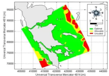
A suitability map based on the ICZM in Galang Island is indicated by sixteen thematic maps, cover-ing buffer zones of more than 200 m to other coastal usage properties. The thematic maps consist of villages, towns, cities, harbours, streams, rivers, ero-sive shoreline, semi intenero-sive hatcheries, ponds, sewage discharges, traffic lanes, and coastal usage.
To analyze land use for coastal utilization in Galang Island, The Author found a large quantity of data and applied it by using a graphic user interface of SYSMAR DSS. As can be seen in Figure 4, of 16 parameter criteria, only 8 main criteria are detected which imposed restrictions on FNC Grouper
develop-ment, such as villages (indicated by number 1), strategy or industry areas located in the north and south domain (shown by number 5), and tourism areas located on the west part of domain (see number 6). Rivers can also be found spread over the domain (see number 8), semi intensive hatcheries and pond areas which the government had planned to extend (number 10), traffic lanes (number 14) and the environmentally protected area including mang-rove zone and coral reef areas (number 16). The analysis of computing ICZM is carried out by adopting data from the master plan of Batam City for 2004–2014 from National Development Planning Agency [19], Sahalo [20] and Indonesian Land use Data Bank [31]. Figure 5 presents an area of 77.5% or about 24,856 Ha of seawater areas being defined optimal, and only 22.5% of the area are categorized as unsuited.
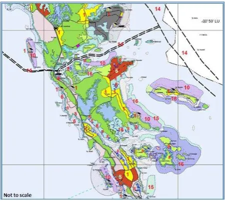
Figure 4. ICZM Criteria in Galang Island [21, 25]
Note: 1: villages, 5: industry, 6: tourism, 8: rivers, 10: semi intensive hatcheries, 14: traffic lanes, 15: coastal usage, 16: environment protected area
.
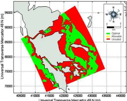
Figure 6. Final Result of the Suitability Map from All Paramaters in the Vicinity of the Galang Island
This study applies the SYSMAR DSS for ICZM and has the ability to integrate the multidisciplinary environment as a complex and variable system. However, the result must be interpreted with caution, because Ferrol-Schulte et al. [32] revealed that the researchers and practitioners have been blurring the boundaries between conservation, deve-lopment, poverty-alleviation and natural resource ecosystem management in Indonesia. The final result of the suitability map from all parameters in the vicinity of the Galang Island can be seen in Figure 6. It shows about 12940 Ha (40.3%) of the seawater area in Galang Island are interpreted as suited area. The areas are spread over the vicinity of the Galang Island. The DSS is an approach to support decision making through the screening of data. The scoping of stakeholders and the scanning of development strategies are found to expand FNC Grouper culture in the vicinity of Galang Island.
Discussion and Conclusion
The aim of this manuscript was to demonstrate the application of the ICZM in DSS for the sustainable management of FNC Grouper cultures. The work is focused on the improvement of ICZM to incorporate the EAA concept of the physical carrying capacity (CC) for sustainable FNC Grouper cultures in Indonesia [33, 34]. The lack of data measurement is recognized as a major problem for development of mariculture in Indonesia, therefore, in order to run the DSS, it is essential to get a great deal of data for site selection analysis by physical model simulation and secondary data including project, research, study, online data source as well as Indonesia government data. The DSS is able to determine potential sites for FNC Grouper culture projects in Galang Island that comply with environmental and sustainability criteria.
This study produced results which confirm the findings of a great deal of the previous work regarding carrying capacity in this field and presented the utilize of GIS to model site selection or physical carrying capacity for FNC Grouper culture in Galang Island based on certain important criteria. The outcomes of site selection in the vicinity of Galang provide further support for the analysis that those physical parameters including water depth, flushing, current, wave, and wind have important implications for estimations of suitable areas in Galang Island. The most interesting finding from Galang Island indicated that the main physical parameter which determined site selection was the water depth fluctuation, which was obtained from model results and bathymetry information. It showed that 21612 Ha (67.4%) are optimal for FNC grouper culture development.
As mentioned in the material and method along withresults, this study shows that water quality parameters in Galang Island are suitable for development of FNC Grouperculture. It is encou-raging to compare this figure with that found by
Coral Reef Information and Training
CentersIndonesian Research Institute [16] who found that sea water quality in the area surrounding Galang Island sub district including Abang Island, Air Saga, Petong Island, Nguan Island, Sembur Island, Karas Island, and Mubut Island were suitable for grouper culture activities. The present findings of SYSMAR DSS seem to be consistent with earlier observations which showed that water quality in the vicinity of Galang Island is suitable for the development of FNC Grouper projects.
usage, and environment protected area are seen to affect the size of the area considered suitable for FNC development. The analysis shows that 77.5% of the area or about 24856 Ha can be defined as an optimal area for FNC Grouper culture with regard to ICZM criteria mentioned in Table 1.
Thus, the present study highlights that physical carrying capacity is obtained from the site selection of SYSMAR DSS implementation with respect to the results of the high resolution of the hydrodynamic and wave numerical model, water quality, and integrated coastal zone management (ICZM). Final-ly, it demonstrates that about 40.3% (12940 Ha) of the seawater area in the vicinity of Galang Island are estimated as suitable area.
Acknowledgements
The Author gratefully acknowledges the support and generosity of The Centre for International Migration and Development (CIM), and the Deutsche Gesells-chaft für Internationale Zusammenarbeit (GIZ). This study was supported by the Directorate General of Higher Education, Ministry of Education and Cul-ture of Indonesia (DGHE), the German Academic Exchange Service or Deutsche Akademische Austau-schdienst (DAAD), the Research and Technology Center Büsum/Forschungs-und Technologie zen-trum Westküste (FTZ)–Büsum and the Inter-national Center, Career Center of Christian-Albrechts-University in Kiel.
References
1. Sugama, K., Public Policy for Sustainable Deve-lopment of Grouper Aquaculture in Indonesia, Directorate of Seed Development - Directorate General of Aquaculture Indonesia, 2010. 2. Burnell, G., Goulletquer, P., Mees, J., Seys,
J., and Stead, S.M., Aquaculture and Its Role in Integrated Coastal Zone Mana-gement – Handbook and Extended Abstracts, European Aquaculture Society, 2001. 3. Hermawan, S., van der Wulp, S.A.,
Niedern-dorfer, K.R., Runte, K.H., and Mayerle, R., System for the Sustainable Management of Floating Net Cage Mariculture (SYSMAR), An Application to Three Selected Regions in Indonesia, Proceeding of Marcoastecos 2012 Conference in Albania, Tirana, Albania, 2012, pp.226-234.
4. Hermawan, S., and Syafrani, An Integrated Decision Support System for the Management of Sustainable Mariculture in Indonesia. Advances in Environmental Biology, 9(7), 2015, pp. 21-27.
5. Nurhidayah, L., Toward Integrated Coastal Zone Management in Indonesia: Framework Assessment and Comparative Analysis. Indone-sian Researcher Institute of Sciences, retrieved from: http://www.un.org/depts/los/nippon/unnff_ programme_home/fellows_pages/fellows_papers /nurhidayah_0910_indonesia.pdf, 2010.
6. Farhan, A.R., and Lim, S., Integrated Coastal Zone Management Towards Indonesia Global Ocean Observing System (INA-GOOS): Review and Recommendation, Ocean & Coastal Mana-gement, 52, 2010, pp. 421–427.
7. Fabbri, K.P., A Methodology for Supporting Decision Making in Integrated Coastal Zone Management, Ocean & Coastal Management, 19, 1998, pp. 51-62.
8. Rodiguez, I., Montoya, I., Sanchez, F., and Carreno, F., Geographic Information System Applied to Integrated Coastal Zone Mana-gement, Geomorphology, 107, 2009, pp. 100-105.
9. Silvert, W., A Decision Support System for Regulating Finfish Mariculture. Ecological Modelling, 75/76, 1994, pp. 609-615.
10. Hargrave, T.A., Traffic Light Decision System for Marine Finfish Mariculture Siting, Ocean and Coastal Management, 45, 2002, pp. 215-235.
11. Mayerle, R., Windupranata, W., A Decision Support System for the Sustainable Environ-mental Management of Marine Fish Farming, Proceeding ofSecond International Symposium on Cage Aquaculture Asia (CAA2), Hangzhou, China, 2006.
12. Van der Wulp, S.A., Niederndorfer, K.R., Hesse, K-J., Runte, K-H., Mayerle, R., and Hanafi, A., Sustainable Environmental Management for Tropical Floating Net Cage Mariculture, A Modeling Approach, XVIIth World Congress of
the International Commission of Agricultural Engineering (CIGR), Quebec City, Canada, 2010.
13. FAO, Site Selection Criteria for Marine Finfish Net Cage Culture in Asia, UNDP/FAO Regio-nal Sea farming Development and Demonstra-tion Project, Network of Mariculture Centers in Asia, FAO Documentation NACA-SF/WP/89/13, 1989.
14. Egbert, G,D. and Erofeeva, S.Y., Efficient Inverse Modeling of Barotropic Ocean Tides, J. Atmos. Tide extracted from Total Model Driver. Oceanic Technol, 19(2), 183-204. Retrieved from:http://www.esr.org/polar_tide_models/Mod el_TPXO62.html#EgbertErofeeva, 2002. 15. National Oceanic & Atmospheric
Retriev-ed from: http://www.cdc.noaa.gov/Global six hourly reanalysis data with the resolution 1.87 degrees (192 x 94 grid) for wind and sea level pressure, 2009.
16. CRITC (Coral Reef Information and Training Centers) COREMAP-LIPI., (COREMAP II) CRITC LIPI, BPP-PSPL Universitas Riau. Study of the Potential Mariculture Development in Coremap II Area: Batam City, In Indonesian language, 2009, pp. 168 .
17. RDCOG Research Development Centre of Ocean Geology. (Pusat Penelitian and Pengem-bangan Geologi Kelautan) Report of Geology Map, Potential Energy and Systematic Mineral Resources (LP. 1017) Batam – Riau Archipe-lago, in Indonesian language, Bandung, Indo-nesia, 2005, pp. 123.
18. Schlitzer, R., Ocean Data View, http://odv.awi. de, 2011.
19. National Development Planning Agency (NDPA), Local Regulations no. 2 of Batam City., Regional Planning of Batam City 2004-2014, In Indonesian Language. Retrieved from: http://perpustakaan.bappenas.go.id/lontar/opac/ themes/bappenas4/templateDetail.jsp?id=9537 8&lokasi=lokal, 2004.
20. Sahalo, M.A., Personal Communication, Natio-nal Development Planning Agency (NDPA), Batam City, Regional Planning of Batam City 2004-2014, Indonesia, 2014.
21. Windupranata, W., Development of a Decision Support System for Suitability Assessment of Mariculture Site Selection, PhD thesis, Chris-tian Albrechts Universitat zu Kiel, 2007, pp. 125.
22. Mayerle, R., Hanafi, A., Hesse, K-J., Van der Wulp, S.A., Niederndorfer, K.R., Runte, K-H., Ladwig, N., Giri, A., Kleinfeld, F., and Sugama, K. Verbundprojekt: WTZ Indonesien: SYSMAR- Integriertes System für das Management einer ökologisch und sozio-ökonomisch nachhaltigen Marikultur in Indonesien, Teilproject 1, Retriev-ed from BMBF-Verbundvorhaben data base. (FKZ 03F0469A), 2011.
23. FAO, Site Selection Criteria for Marine Finfish Net Cage Culture in Asia, UNDP/FAO Regio-nal Sea farming Development and Demonstra-tion Project, Network of Mariculture Centers in Asia, FAO Documentation NACA-SF/WP/89/ 13, 1989.
24. Cross, S.F., and Kingzett, B.C., Biophysical Criteria for Shellfish Culture in British Columbia: A Site Capability Evaluation System, Aquametrix Research Ltd., Sidney.B.C, 1992.
25. Kapetsky, J.M., and Aguilar-Manjarrez, J., Geographic Information Systems, Remote Sensing and Mapping for The Development and Management of Marine Mariculture, FAO Fisheries and Mariculture Department, Rome, 2007.
26. Szuster, W.B. and Albasri, H., Site Selection for Grouper Mariculture in Indonesia, Internatio-nal JourInternatio-nal of Fisheries and Mariculture, 2(3), 2010, pp. 87-92.
27. Act no. 25., Establishment of the New Riau Archipelago Province. In Indonesian language, www.bpkp.go.id/uu/filedownload/2/41/310.bpkp, 2002.
28. Bakosurtanal (Badan Koordinasi Survey dan Pemetaan Nasional), National Coordinator for Survey and Mapping Agency, Indonesia. Nautical chart number 42, Indonesia, 2011. 29. Dasminto, Coastal Management at Industry
Area of Batam City, Riau Archipelago Province. In Indonesian Language, MSc Thesis, Sekolah Pasca Sarjana, Bogor Agricultural University, Bogor, 2007, pp. 177.
30. Diansyah, G., Water Quality of Coastal Water in Batam Island, Riau Archipelago Regarding Characteristic of Physics, Chemistry and Plankton Structure Community. In Indonesian language, Thesis, Bogor Agricultural Univer-sity, Bogor, 2004, pp. 85.
31. BW Geohydromatic, Indonesian Land Use Data Bank (ITB), Resolution 1:500,000, Jalan Biologi No. 20 Cigadung, Bandung 40191 – Indonesia, 2006.
32. Ferrol-Schulte, D., Wolff, M., Ferse, S., and Glaser, M., Sustainable Livelihoods Approach in Tropical Coastal and Marine Social-Ecological System: A Review, Marine Policy, 42, 2013, pp. 253-258.
33. Inglis, G.J., Barbara, J.H., Ross, A.H., An Overview of Factors Affecting the Carrying Capacity of Coastal Embayments for Mussel Culture, NIWA, Christchurch, Client Report CHC,00/69, 2002, pp. vi+31.
34. FAO, Technical Guidelines for Responsible Fisheries, Aquaculture Development 4, Eco-system Approach to Aquaculture, retrieved from: http://www.fao.org/docrep/013/i1750e/ i1750e.pdf, 2010.
![Figure 1.Scheme of the Suitability Assessment: a) Reclassification of Bathymetric Information b) Estimation of a Final Score Using an Overlay Procedure [22]](https://thumb-ap.123doks.com/thumbv2/123dok/3649288.1465274/2.595.76.520.607.733/suitability-assessment-reclassification-bathymetric-information-estimation-overlay-procedure.webp)
![Table 1.Site Selection of Groupers Grown in Floating Net Cages [4].](https://thumb-ap.123doks.com/thumbv2/123dok/3649288.1465274/3.595.75.538.364.779/table-site-selection-groupers-grown-floating-net-cages.webp)