FIRST AID EMERGENCY SYSTEM USING
NETWORK VORONOI DIAGRAM BASED KTH-NEAREST NEIGHBOR
SISTEM PERTOLONGSN PERTAMA MENGGUNAKAN
NETWORK VORONOI DIAGRAM BERDASARKAN KTH-NEAREST NEIGHBOR
1Ashari Fachrizal Nuhrintama, 2Kiki Maulana Adhinugraha
1,2
Prodi S1 Teknik Informatika, Fakultas Informatika, Universitas Telkom
1[email protected], 2[email protected]
Abstract
Emergency is an event that can threaten and disrupt a person's life. Emergency situation occur suddenly with unexpected place and time. Many fatal impact in emergency can be prevented or reduced by adequate first aid. Most countries have implemented some form of emergency services in order to do first aid in emergency situation like traffic accident. In Bandung city, emergency services used 112 as a single emergency call and managed by operators. These operators have to decide which unit is nearest to emergency location. The environment they operate is characterized by high degree of uncertainty, as they don't know exact distance from each unit to emergency location. K-nearest neighbor (KNN) can be used to finding nearest emergency unit. However, with the high number of emergency calls in Bandung city, KNN has high computational cost. It has to measuring each emergency unit distance to emergency location over and over. With Network Voronoi diagram (NVD) as extension, KNN's role can be optimized to find nearest emergency units by partitioning space into territories for each unit. So NVD can directly gets the nearest unit by looking into which unit's territory emergency location exist.
Keywords: Emergency, First aid, Network Voronoi Diagram, Kth Nearest Neighbor
Abstrak
Keadaan darurat adalah peristiwa yang dapat mengancam dan mengganggu kehidupan seseorang. Keadaan darurat terjadi secara tiba-tiba dengan tempat dan waktu tak terduga. Banyak dampak fatal dalam keadaan darurat dapat dicegah atau dikurangi dengan bantuan pertama yang memadai. Sebagian besar negara telah menerapkan beberapa bentuk layanan darurat untuk melakukan pertolongan pertama dalam situasi darurat seperti kecelakaan lalu lintas. Di kota Bandung, layanan darurat telah menggunakan nomor telepon 112 sebagai panggilan darurat dan dikelola oleh seorang operator. Operator ini harus memutuskan unit mana yang terdekat dengan lokasi darurat. Lingkungan mereka beroperasi memiliki tingkat ketidakpastian yang tinggi, karena mereka tidak mengetahui jarak yang pasti dari masing-masing unit ke lokasi darurat. K-Nearest Neighbor (KNN) dapat digunakan untuk menemukan unit gawat darurat terdekat. Namun, dengan tingginya jumlah panggilan darurat di kota Bandung, KNN memiliki biaya komputasi yang tinggi. Ini harus mengukur setiap jarak unit gawat darurat ke lokasi darurat berulang-ulang. Dengan Network Voronoi Diagram (NVD) sebagai tambahan, peran KNN dapat dioptimalkan untuk menemukan unit gawat darurat terdekat dengan mempartisi ruang ke wilayah untuk setiap unit. Sehingga NVD bisa langsung mendapat unit terdekat dengan melihat ke dalam lokasi darurat wilayah unit mana yang ada.
Kata Kunci: Keadaan Darurat, Pertolongan Pertama, Network Voronoi Diagram, Kth Nearest Neighbor
1. Introduction
Emergency is an abnormal event that has negative impact because it can threaten and disrupt a person's life. Emergency occurs suddenly with unexpected place and time. An emergency can be presented in many forms; from everyday incidents like traffic accident or assault, to major incidents like wildfire, earthquake, or large-scale terrorist attacks.
The 112 emergency services emergency requests received per day
by specially trained operators. The operator have to decide which nearest emergency unit to dispatch to emergency location every time emergency happens. The environment they operate is characterized by high degree of uncertainty. Its because they don't know the exact distance from each unit to emergency location which inconvenience them to determining nearest emergency unit.
In computer science, finding nearest emergency unit can be determine by using K-Nearest Neighbor (KNN) algorithm. Consider road network in Bandung shown in Figure 1(a), where emergency happens in Query Point (QP). KNN needs to determine each emergency unit distance to QP before comparing it and pick up the emergency unit with minimum distance. So in Figure 1(a), the nearest ambulance is C-ambulance. Notice that if there are emergency requests from many different location, then these process will repetead for each request. More requests means more processes KNN will takes.
Each emergency unit basically has a coverage area which specifies that its closer to the emergency unit than others. It can be done by using Network Voronoi Diagram (NVD) algorithm. NVD works as shown in Figure 1(b), where every road network's color represented each emergency unit's territories. So when emergency happens, NVD just needs to determine which emergency unit's territory emergency exist. In Figure 1(b) QP exist in C-ambulance with green territory which is the nearest ambulance.
This final project presents Network Voronoi Diagram based Kth-Nearest Neighbor development for 3 emergency services (ambulance, police, and fire brigade) in Bandung. In general, when an emergency occurs, user contact 112 to make a report. System will determine user coordinate location and select nearest emergency unit. System also support finding next nearest emergency units if nearest unit is on duty. The selected unit will be dispatch after receiving shortest path to the emergency location.
2. Method of Investigation
2.1 System Description
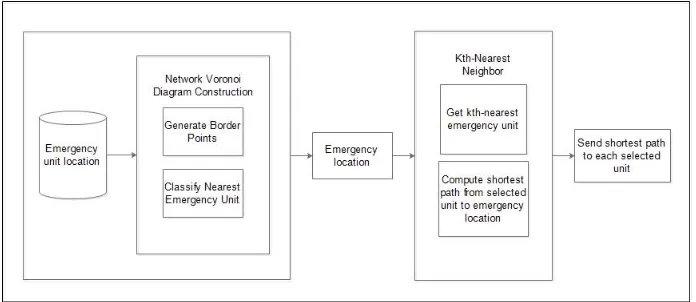
The system built on this research is the first aid emergency system by using Network Voronoi Diagram based Kth-Nearest Neigbor. In general, the system can be seen in Figure \ref{fig:system_description} below. First, system accepts input user location where emergency happens. Then the system will process the input to determine nearest emergency units to emergency location that has been divide using Network Voronoi Diagram. If the selected unit is on duty, system will looking for next nearest emergency unit using Kth-Nearest Neighbor. After kth-nearest emergency unit selected, system determines the shortest path from their location to emergency location. And the last, system sends data to the results of this process to each selected emergency unit so that they can immediately go to the emergency location to do first aid.
Figure 2. System Description
2.2 System Flowchart
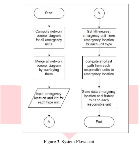
Figure 3. System Flowchart
a). System construct network voronoi diagram to get each vertex perspective about its nearest emergency unit
so it will make a territory for each unit in same unit type.
b). System merge all network voronoi diagram (nvd for ambulance, nvd for police, and nvd for fire brigade),
which has been constructed by overlaying all of them.
c). System gets emergency location inputs where emergency occurs.
d). System determining nearest unit to emergency location. If selected unit is on duty, system will looking into next nearest unit. Until system find it an appoint it as responsible unit.
e). System compute shortest path from each responsible units to emergency location.
f). System sends data emergency coordinates location and shortest path from each responsible units to the location.
2.3 Data Collection
Data collection needed as support for determining nearest emergency unit from emergency location. The data collected are:
- Bandung road network map
these map contains some public road network in Bandung City partially including south side, west side, east side, and center side. The public road network includes arteries and collector road type.
- Coordinate location data of ambulance units
these coordinate location data of ambulance units are obtained from portal data Bandung.
- Coordinate location data of police units
these coordinate location data of police units are obtained from Kepala Polisi Resor Bandung and portal data Bandung.
- Coordinate location data of fire brigade units
2.4 Data Processing
Data processing step serves to find responsible units and generate shortest path from them to emergency location. This step can be explained as follows:
2.4.1 Process Determining Border Point
Input : road network, ambulance units coordinate point, police units coordinate point, fire
brigade units coordinate point
Output : ambulance units border point, police border point, fire brigade border point
Border point denotes middle distance from two adjacent emergency units. Border point will act as outer parts from a emergency unit's territory. To determining border points, system needs to read road network and also coordinate point of each emergency unit. After system reads the input, each emergency units will be selected as starting point and expand to other vertex which share same edge
with them. Border point obtained when expanding process meets another emergency unit.
2.4.2 Process of Classifying nearest unit
Input : road network, ambulance units coordinate point, ambulance units border point,
police units coordinate point, police units border point, fire brigade units coordinate point, fire brigade units border point
Output : ambulance units network voronoi diagram, police network voronoi diagram, fire
brigade network voronoi diagram
This step works by classifying nearest generator (1-NN) for each vertex in plane. Network voronoi diagram will shows territory of each unit in same type. To construct NVD, system needs to read road network and all vertex including generator, border points, or normal vertex. This process will be computed three times because there are three types of units (police, ambulance, fire brigade).
2.4.3 Process of Determining Emergency Location
Input : emergency coordinate location
Output : map with emergency location
This step is works by determining coordinates of emergency location based on emergency request. When emergency call comes, network connectivity points (e.g., cellular towers of cellular networks) will detect user coordinate location and report it to emergency service system. The emergency location become endpoint in route determination to finding shortest path from selected unit.
2.4.4 Process of Determining Kth-Nearest Emergency Unit
Input : emergency coordinate location, kth-selected
Output : selected unit
This step intended to selecting number of k for type unit which emergency needed. If the nearest unit on duty, system will determine next nearest unit with adjacency generator list as control. The nearest emergency unit's neighbour becomes candidate to next nearest unit. These candidates will sorted by minimum distance to emergency location. Then, system pick up kth-nearest emergency unit to emergency location The selected unit will become starting point in route determination.
2.4.5 Process of Determining Shortest Path from Selected Unit to Emergency Location
Input : selected unit location, emergency location
Output : nearest route
3. Evaluation
3.1 Result of NVD Construction
Determining nearest emergency unit required by dividing plane into each emergency unit coverage area. Every coverage area represent that the location inside it will returns its generator for nearest emergency unit. The NVD construction consists of several phases shown as below :
3.2.1 Border Point Determination
Conducted to obtain the outermost point of the power area of an emergency unit. Border point is done by tracing each path starting from the starting point of an emergency unit. Search continues until met to another emergency unit. Both units become neighbors separated by a border point that occupies the midpoint of the traced path.
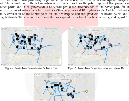
The result of data processing to get border point is divided into 3 parts for each type of emergency unit. The second part is the determination of the border point for the police type unit that produces 44 border points and 16 neighborhoods. The second part is the determination of the border point for the emergency unit of ambulance which produces 29 border points and 10 neighborhoods. And the third part is the determination of the border point for the fire brigade unit that produces 19 border points and 4 neighborhoods. The result of determining the border point for each unit can be seen on Figure 4, 5, and 6.
3.2.2 Nearest Emergency Unit Classification
The classification of the nearest emergency unit is used to classify the nearest unit for each location in Bandung so that each emergency unit has a coverage area indicating that the unit is the nearest unit. The results of the classification of the nearest emergency unit to obtain the coverage area of each unit is divided into 3 parts according to the type of emergency services. The first part is the nearest emergency unit classification for police which divides Bandung into 10 coverage area. The second part is the nearest emergency unit classification for ambulance that divides Bandung into 8 coverage area. The third part is the nearest emergency unit classification for fire brigade that divides Bandung into 4 coverage area. The results of NVD formation for each emergency unit can be shown on Figure \ref{fig:nvd_pol}, \ref{fig:nvd_amb}, and \ref{fig:nvd_fbg}.
Figure 4. Border Point Determination for Police Unit Figure 5. Border Point Determination for Ambulance Unit
3.2 Kth N-NVD vs Basic KNN
This experiment works by comparing overall performances of kth N-NVD and basic KNN. The experiment used two real-world datasets. The first dataset consists a network of approximately 780 links and 500 nodes of the road system in Bandung. The second dataset consists of a set of points representing police, ambulance, and fire brigade in Bandung containing 10, 8 , and 4 objects, respectively. The experiment present the average results of 20 runs of kth-nearest neighbor queries where k varied from 1 to 10.
3.2.1 Execution Time
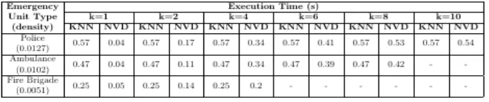
Experiment show that the total execution time of KNN based NVD less than that of KNN. Table \ref{table:execution_time_compare} shows the result of comparing total execution time between KNN based NVD and basic KNN. The first columns specify the emergency unit in Bandung. Note that for the given dataset, unit police and fire brigade represent the emergency units with the maximum and minimum number of units in Bandung. Basic KNN always returns stable execution time regardless k value. This because to find nearest emergency unit, KNN must measure all distance from emergency location to each emergency unit before sorting it based on minimum distance. So when k=1 kth N-NVD generates the result set almost instantly. This is because NVD has generate territory for each emergency unit so its enough to find 1-NN by only looking for which unit emergency location exists. However, basic KNN requires between 0.25 to 0.57 seconds to provide 1-NN. For larger k, kth N-NVD has a total execution time similarly with basic KNN. This is because each unit has been candidates and measured its distance to emergency location.
Tabel 1. Execution Time Comparison between kth N-NVD and basic KNN
Figure 7. Network Voronoi Diagram for Police Unit Figure 8. Network Voronoi Diagram for Ambulance Unit
4. Conclusions and Suggestions
Based on the results of this final project that has been done, can be drawn conclusions that refers to the objectives into the following subsection:
1) All objectives are successfully designed implemented using kth N-NVD approach
2) Kth N-NVD outperforms basic KNN in execution time by a factor of 1.05 to 14.25 depending on the
value of k for determining nearest emergency units.
Suggestions that can be submitted from the results of this study for further research development are as follows:
1) Adding another emergency services like military, coast guard, etc. By adding another emergency services makes system more complete.
2) Finding kth-nearest emergency unit based on travel time by considering road conditions. By determine travel time makes system more accurate to real life condition.
5.
References[1] G. F. Bonham-Carter, "Geographic Information Systems for Geoscientists: Modelling with GIS," Vol. 13. Elsevier, 2014.
[2] M. Erwig, "The Graph Voronoi Diagram with Applications," Network Vo.36: 156-163, 2000.
[3] A. Hannawati, Thiang, Eleazar, "Pencarian Rute Optimum menggunakan Algoritma Genetika," Teknik Elektro Vo.2: 78-83, 2002.
[4] A. Hauke, P. Georgiadou, H. Kallio, S. Meyer, G. Nicolescu, "Emergency Services: A Literature Review on Occupational Safety and Health Risks," 2011.
[5] R. Jampani, R. Thonangi, P. Gupta, "Overlaying Multiple Maps Efficiently," 2004.
[6] M. Kolahdouzan, C. Shahabi, "Voronoi-based K Nearest Neighbor Search for Spatial Network Databases," Figure 10. Execution Time Comparison for Police Unit Figure 11. Execution Time Comparison for Ambulance Unit
2004.
[7] S. Medjahed, T. Saadi, A. Benyettou, "Breast Cancer Diagnosis by Using K-Nearest Neighbor with Different Distances and Classification Rules," International Journal of Computer Applications Vol. 62- No.1, 2013.
[8] I. Mutakhiroh, "Pencarian Jalur Terpendek menggunakan Metode Semut," Seminar Nasional Aplikasi Teknologi Informasi 2007 (SNATI2007), 2007.
[9] A. Okabe, B. Boots, K. Sugihara, "Spatial Tesselation Concepts and Applications of Voronoi Diagrams," Wiley Series in Probability and Mathematical Statistics, 2000.
[10] C. M. Ondieki, S. Murimi, "Application of Geographic Information Systems," Environmental Monitoring Vol. 11, 1997.
[11] B. C. Ooi, R. Sacks-Davis, J. Han, "Indexing in Spatial Databases," 1993.
[12] E. Prasetyo, "Fuzzy K-Nearest Neighbor on Every Class untuk Klasifikasi Data," Teknik Informatika-Fakultas Teknologi Industri Universitas Pembangunan Nasional pp 57-60, 2012.
[13] P. L. N. Raju, "Fundamental of Geographical Information System," 1997.
[14] F. Takehiro, S. Atsuo, I. Keisuke, "The Kth Nearest Voronoi Diagram and its Application to Districting Problem of Ambulance Systems," 2005.
[15] H. Weiping, W. Chi, "Urban Road NEtwork Accessibility Evaluation Method based on GIS Spatial Analysis Techniques," The International Archives of The Photogrammetry, Remote Sensing and Spatial Information Sciences, Vol. 38, Part II, 1989.
[16] Q. Zhang, "Road Network Generalization based on Connection Analysis," 2005.