SUSTAINABLE FISHERIES
MANAGEMENT PROJECT (SFMP)
Climate Change Adaptation Options
for Axim and Sanwoma Communities
with Emphasis on Fish Processing
Households
This publication is available electronically in the following locations: The Coastal Resources Center
http://www.crc.uri.edu/projects_page/ghanasfmp/
Ghanalinks.org
https://ghanalinks.org/elibrary search term: SFMP
USAID Development Clearing House
https://dec.usaid.gov/dec/content/search.aspx search term: Ghana SFMP
For more information on the Ghana Sustainable Fisheries Management Project, contact:
USAID/Ghana Sustainable Fisheries Management Project
Tel: 401-874-6224 Fax: 401-874-6920 Email: [email protected]
Citation: Adams Osam, Stephen Kankam and Peter Owusu Donkor, 2016. Climate Change Adaptation Options For Axim And Sanwoma Communities With Emphasis on Fish Processing Households. The USAID/Ghana Sustainable Fisheries Management Project (SFMP). Narragansett, RI: Coastal Resources Center, Graduate School of Oceanography, University of Rhode Island. GH2014_ACT082_HM_SpS. 33 pp
Authority/Disclaimer:
Prepared for USAID/Ghana under Cooperative Agreement (AID-641-A-15-00001), awarded on October 22, 2014 to the University of Rhode Island, and entitled the USAID/Ghana Sustainable Fisheries Management Project (SFMP).
This document is made possible by the support of the American People through the United States Agency for International Development (USAID). The views expressed and opinions contained in this report are those of the SFMP team and are not intended as statements of policy of either USAID or the cooperating organizations. As such, the contents of this report are the sole responsibility of the SFMP team and do not necessarily reflect the views of USAID or the United States Government.
Detailed Partner Contact Information:
USAID/Ghana Sustainable Fisheries Management Project (SFMP) 10 Obodai St., Mempeasem, East Legon, Accra, Ghana
Telephone: +233 0302 542497 Fax: +233 0302 542498
Maurice Knight Chief of Party [email protected]
Kofi Agbogah Senior Fisheries Advisor [email protected] Nii Odenkey Abbey Communications Officer [email protected]
Bakari Nyari Monitoring and Evaluation Specialist [email protected] Brian Crawford Project Manager, CRC [email protected]
Justice Odoi USAID Administrative Officer Representative [email protected]
Kofi.Agbogah
For additional information on partner activities:
CRC/URI: http://www.crc.uri.edu
CEWEFIA: http://cewefia.weebly.com/
DAA: http://womenthrive.org/development-action-association-daa Daasgift:
https://www.facebook.com/pages/Daasgift-Quality-Foundation-FNGO/135372649846101 Friends of the Nation: http://www.fonghana.org Hen Mpoano: http://www.henmpoano.org
SNV: http://www.snvworld.org/en/countries/ghana SSG Advisors: http://ssg-advisors.com/
ACRONYMS
TABLE OF CONTENTS
CONTENTS
ACRONYMS ... iii
TABLE OF CONTENTS ... iv
LIST OF FIGURES ... v
LIST OF TABLES ... v
INTRODUCTION ... 1
METHODOLOGY ... 3
Study Setting ... 3
Data sources and Analysis ... 4
RESULTS AND DISCUSSIONS ... 5
Coastal hazards in Axim and Sanwoma... 5
Fish infrastructure, households and business at risk ... 12
Mapping low risk zones for sitting fish processing infrastructures ... 18
Short term flood mitigation strategies (Action Based) ... 22
Long term Adaptation measure ... 25
CONCLUSIONS... 26
LIST OF FIGURES
Figure 1 Map of Axim and Sanwoma ... 3
Figure 2 High water mark in Sanwoma ... 5
Figure 3 High water mark in Axim ... 6
Figure 4 Frequency of sea level rise/ flooding to houses... 7
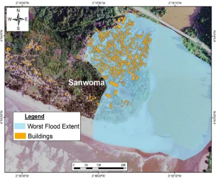
Figure 5 Flood hazard map of Sanwoma (worst flood experienced) ... 8
Figure 6 Buildings close to the Ankobra River in Sanwoma community ... 9
Figure 7 Evidence of sea erosion on the coast of Axim and Sanwoma ... 10
Figure 8 Impacts of erosion in Axim ... 11
Figure 9 Distribution of fish processing kitchens in Axim and Sanwoma ... 12
Figure 10 Types of ovens; (A) Circular ovens (B) Rectangular ovens (chorkor smoker) (C) Morrison stoves (D) Kosmos improved ovens ... 13
Figure 11 Distance of Kitchens from the Sea and with high water mark in Axim ... 14
Figure 12 Distance of Kitchens from the sea and distance of high water mark in Sanwoma . 15 Figure 13: Vulnerability of fish processing households to climate change ... 16
Figure 14 Business in Axim (100 meters away from the sea) and Sanwoma at risk to sea level rise ... 17
Figure 15 Daily sales of some businesses in Axim and Sanwoma ... 18
Figure 16 Risk zones in Axim community ... 20
Figure 17 Risk zones in Sanwoma ... 21
LIST OF TABLES
Table 1 Risk levels within Axim ... 19Table 2 risk levels within Sanwoma ... 19
Table 3: Estimated cost of climate change awareness actions ... 23
Table 4: Estimated cost on restoring coastal ecosystems ... 24
Table 5 Estimated cost on improving household income levels and opportunities ... 25
INTRODUCTION
Sea fronts and rivers provide great economic and social advantages. They have been pivotal in the development and growth of countries across the globe; promoting commerce, trade, tourism and fishing. They have ultimately motivated the growth of most cities in ancient times and still continue to attract diverse migrants from landlocked regions making them the
world’s most densely populated zones (Neumann, Vafeidis, Zimmerman & Nicholls, 2015).
Unfortunately, coastal areas are highly prone to hydro meteorological hazards such as floods (river and sea level rise), hurricane, coastal storms, and sea erosion (Singh, Pathirana & Sui, 2006). Factors accounting for the high susceptibility of coastal areas to these hazards are low elevations, presence of larger river systems, availability of wetlands and physical human developments.
Elevations of most coastal areas are below 30 meters allowing easy inundation by the sea and rivers with minimal increase in water levels. High tides and storm surges flow inland
covering extensive portions of coastal fronts which wrack havoc (Trenberth, 2011).
Anthropogenic developments such as physical developments have altering coastal landscapes with extensive concrete surfaces reducing percolation rate of rainfall contributing to coastal floods (Okyere, Yacouba & Gilgenbach, 2012). All coastal towns are currently witnessing rapid encroachment of wetland and riparian vegetation which is producing lasting effects of intense flooding with minimal rainfall.
Another threat to life, property and ecosystem functions in coastal areas is sea erosion and accretion. Coastal accretion has led to the siltation of most wetlands which has,
consequently, resulted in the reduction of its ecosystem functions. On the other hand, erosion has invaded settlements and washed away buildings and structures within meters of the sea, exposing human habitats to a great risk.
The emergence of global warming has also heightened the effects of hydro meteorological hazards. For instance, increasing temperatures as a result of climate change have led to thermal expansion sea water and the melting of glacier resulting in millions of tons of fresh water entering the sea yearly (Nicholls et al, 2007). This is responsible for increasing sea levels with an annual rate of 3.2 mm based on a satellite altimetry assessment from 1993 to 2013 (CSIRO, ) and a future rise of 1 to 4 feet by 2100 (National Climate Assessment, 2014). This presents a gloomy picture for the already stressed coastal ecosystems and vulnerable settlers with their fragile livelihood systems as an estimated 21million people with assets valued over 96 billion are at risk (Winsemius & Ward, 2015).
Households in less developed countries are highly at risk to sea level rise and river floods perpetuated by climate change. The main contributing factors to their high vulnerability are a result of physical, social and economic conditions of most households. Physically, buildings are made of low quality materials such as adobe and unconsolidated materials which are less resistant to floods and thus, melt easily or get carried away (Tiepolo, 2014). Buildings with improved materials as blocks and bricks lack water proofing membranes and architecture to help secure people and household assets during inundation. From a social perspective, large family sizes, low level of education, inequality and marginalization place a strain on
Floods are recurring phenomena in most coastal towns in Ghana. Urbanized areas are the worst affected by floods with large coverage of affected persons. In rural Ghana, flooding is usually not because of improper physical developments, as in urban centers. Heavy rainfall within river catchment and high rate of sedimentation of rivers are the causes of floods. Flood occurrences in rural areas tend do not generate the needed media attention as spatial extent and persons affected are usually smaller. Nonetheless they have devastating effects on the economic and wellbeing of rural folks.
Climate change presents a major concern for Sanwoma and Axim which are rural
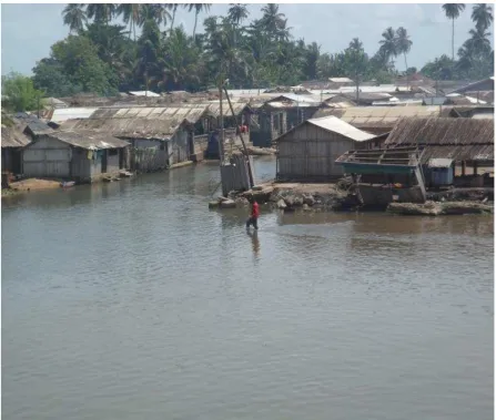
communities in the Western Region of Ghana. Sanwoma is an estuarine community exposed to both riverine floods from the Ankobra River and sea level rise. Flooding (riverine and sea level rise) is synonymous with the rainy season, thus the community is inundated always in the wet season. People in the community have grown to accept flooding as part of their daily experiences. It is, therefore, expected that they would have developed strategic adaptive interventions and measures at either individual household levels or community levels. But this is not the case, as most houses in the area have no foundations or bases. This makes it easy for flood waters to enter houses and destroy assets. One significant problem with these floods is the destruction of fish processing ovens in Sanwoma as they constitute a major source of income for most households. The fishing ovens are made primarily of adobe, which easily dissolves when it comes into contact with water. The destruction of these ovens during floods limits the fish processing ability of various households. Household income levels dwindle impacting the wellbeing of all households.
Efforts to reduce recurring destruction of ovens led to the establishment of much more
resilient ovens by Kosmos Energy and Tullow. This has been useful to fish processors but not without limitations. The number of ovens installed is inadequate considering the number of persons involved in fish processing in Sanwoma community. Another limitation is the quantity of fish that could possibly be processed at a time. These factors influence the patronage of the improved ovens.
In Axim, sea level rise and erosion are the hazard events experienced. They are not new concepts in this community as it has persisted since the colonial times. The magnitude of sea wave action and its impact on the shores of Axim led to deposition of rocks and the
construction of a sea defense wall by the first government of Ghana led by Dr Kwame
Nkrumah. People were resettled behind this hardened line of defense. Evidence of lost human settlements is still visible during low tides. The intervention brought relief to inhabitants and helped sustained the fishing economy and its related businesses; a purpose well served over time. Recently these defenses have begun to collapse due to aging and increase in force of wave action. Vulnerability of sea front infrastructures has also increased due to sand winning activities by locals for constructions. Indigenes in Axim have also destroyed available
wetlands by turning them into landing sites, hence reducing the resilient and protective ability of the shoreline. These activities result in the overspill of waves into both residential and commercial structures close to the sea. A logical future forecast is a complete washout of buildings, land sites and fish processing equipment such as ovens within few meters of the sea. Such a situation will bring untold hardship on inhabitants of Axim as their residential accommodation will be washed away and their fishing livelihood likely gone.
of fish processing infrastructure within these communities. Lastly, recommendations are made for short and long-term flood hazard mitigation with thier cost implications.
METHODOLOGY
Study Setting
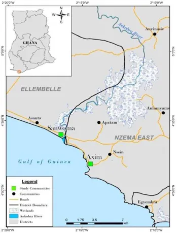
The areas under study are located within the Western Region of Ghana. Axim and Sanwoma are coastal communities besieged by the impact of sea level rise and flooding. Axim is the
district capital of the Nzema East district. Axim is located on latitude 40 51’ 55’’N and longitude 20 14’28’’W. While Sanwoma is found on latitude 40 54’ N and longitude 20 16’ 27’’W. Axim and Sanwoma are about 6km apart and share similar traits in climate, geology,
soil, vegetation and occupation.
Elevations here are low, accounting for their susceptibility to sea level rise and flooding. The study communities are within the south western equatorial climatic region. As a result, they
enjoy two major rainfall patterns mostly, April to July and September to November before experiencing dry season from December through to February. Mean rainfall for the year ranges between 1500 mm and 2000 mm (Tanu 2008). The months of June and July record the highest rainfall amounts which induce the overflow of the Ankobra River resulting in most flood events in Sanwoma. The area enjoys a mean temperature of about 26.30 c with relative humidity usually 75% - 85% high. This accounts for the high and frequent shower of rainfall within the area.
The soil types in Axim and Sanwoma differ largely from each other based on separate watersheds in which they are located. Sanwoma falls within the Ankobra River basin with dominate soil type as fluvisol. Deposition of fine silt carried downstream by Ankobra River accounts for its formation underneath by a granitoid geology type. Fluvisols are typically found on topography that is flooded periodically by surface waters or rising groundwater, thus floodplains and deltas in coastal lowlands (FAO, 2016). Axim is on a minor coastal basin under laid by metamorphosed lava weathered ferralsols. Despite the varying soil type and geology, Axim and Sanwoma share the same vegetation type – strand and mangrove. Patches of grass and shrubs are the common vegetation cover in these communities.
Mangrove forests are limited but confined to river estuaries which are diminishing at a faster rate both from sea impact and anthropogenic influences. Mangrove vegetation has a
protective capacity to sea wave advances but their fragmentation and near destruction has increased vulnerability of the shoreline and inhabitants in these communities.
Data sources and Analysis
Methodology employed ranged from spatial techniques, observations and field interviews schedules. On-screen digitizing of aerial photos was employed to capture all structures within Axim and Sanwoma. This was complemented by field GPS mapping of fish processing ovens. The research team mapped all mapped high tide or sea level within each of the communities at various points. A flood extent map was generated through a participatory approach. Indigenes in Sanwoma were made to draw the extent of the worst flood
experienced within the community. Drawings were made on orthophotos overlaid with transparent material. Drawn flood extent was georeferenced and digitized to create flood map. An overlay of the flood extent data and structures mapped helped identify
infrastructures at risk within Sanwoma.
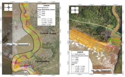
Digital shoreline assessment software was employed in mapping shoreline erosions in these communities. Sea level rise has a direct impact and effect on the level of shoreline erosion. Various shoreline years were captured for the analysis: 2013, 1996 and 1970. The 1970 and 1996 shorelines were extracted from toposheets covering the study areas. The shoreline for 2013 was digitized from google earth. Due to the various sources of the data employed, there were few errors and uncertainty levels. Shorelines from the toposheets had uncertainty range of +/- 4.2 while the 2013 shoreline had 9.3 uncertainty levels. Transects were cast through these shorelines to estimate the rate of end point rate of shoreline movements in these communities.
A set of criteria such as distance from waterbody (lagoon, sea, river), distance from structures, distance from road (accessibility), number of structures in a given cluster, elevation and shoreline erosion rate were analyzed simultaneously. These criteria were analyzed using Spatial Multicriteria Evaluation Tool in Integrated Land and Water Information Systems software. This tool allowed for mapping risk zones within the study areas since risk zones were used in making recommendations for sitting new fish processing infrastructure within the study area and to inform future planning.
RESULTS AND DISCUSSIONS
Coastal hazards in Axim and Sanwoma
Axim and Sanwoma are exposed to different sources of floods and magnitude. The sea, gutters, wetlands and Ankobra River are the main sources of floods in these communities. This view was shared by respondents within these communities as 76% attribute the common source of flooding to the sea, 13% rivers, 7% wetlands/lagoons and 4% to gutters and drains.
The sea doesn’t only inundate houses and properties but its wave actions have also lead to
erosions along the beaches of Axim and Sanwoma. Sea level rise and inundation
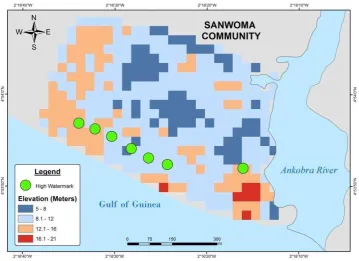
Sea water easily moves into these communities mainly because of low elevation. The maximum elevation for sanwoma is 21 meters with a lowest of 5 meters and a mean of 10.8 meters above sea level (Figure 2).
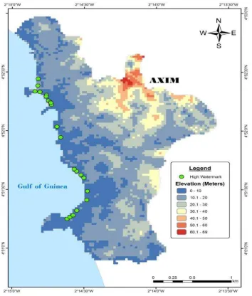
The high water mark is able to reach about 128.68 meters inland inundating houses within Sanwoma (Figure 2). Elevation figures in Axim are better than Sanwoma as the mean elevation is 17.9 meters and the highest point around 69 meters (Figure 3). Unfortunately, most of the inhabitants and businesses are rather concentrated within 10 meters contour. This zone has over 94% of buildings and is the main economic or business hub in Axim.
Frequent sea water movement inland places people, buildings, and these businesses at risk. Even though sea level rises inland are very uneven in Axim because of dotted headlands which are high for sea water to move on land, the bay communities such as Bariwa in Upper Axim and Apewosika experiences the most of sea water movement on land. The high water mark can reach about 52 meters inland from the shore. Unfortunately most fish processing facilities and infrastructures are within the high water mark. High elevation zones 30.1 above have less population concentration as most people want to be close to the sea to enjoy the lucrative fishing and its supporting activities since the closer you are to the coast the easier it is for one to wait for fishermen returning with their catch. Also, the coast brings together a large populace in the day with all sort of commercial activities people want to take advantage of.
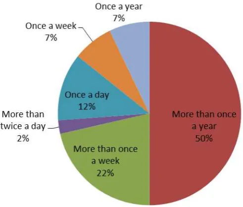
Figure 4 Frequency of sea level rise/ flooding to houses
Being close also comes with the disadvantage of flooding from the sea. Over 50% of responsdents within 200meters of the sea experience flooding at least once a year. Other have sea wave trending close to their houses during high tides at least once a day (Figure 4). This intrusion of sea water is likely to worsen with the advent of climate change as the frequency to houses is likely to increase.
Floods from Rivers
In recent times, rainfall activities are very intense within the Ankobra River with figures over 1500mm yearly (Tanu, 2008). Also, human activities are contributing to the shallowness of Ankobra River channel and by extension, inducing flooding. Ankobra River basin is rich with gold bearing rocks and sediments. Small scale operators on daily bases clear large parts of vegetative cover within the basin in search of gold. They often wash directly mined gold bearing sediments into the Ankobra River. Such activities have increased the sediment load of the Ankobra River leading to shallowness of the river, hence stimulating flooding. The inhabitants of Sanwoma are also to share in the responsibility of frequent destructive effects of floods on their livelihoods as they have settled very close to the Ankobra River banks (Figure 6). The mean distance of buildings away from the river is 182 meters. This violates planning and physical development principles.
The blame cannot be apportioned to changing climate conditions and mining activities alone. A buffer along a river body is needed to regulate development and help protect people’s assets. In Sanwoma, no buffer exists between buildings and the Ankobra River. This can be attributed to lack of political will and enforcement by the Town and Country Planning
Department. Another possible measure to curtail the devastating effects of floods on people is relocation which has been proposed by developers. This has not yielded the necessary results mainly because people have grown accustomed to their current places of resident and find it difficult to relocate. Socially, people want to maintain close contact and bonds with friends and relatives which resettlement into new lands will break. Another reason for the
unsuccessful resettlement story has been the high cost of land in the new settlement community (Sanwoma Newsite).
Floods from Gutters and Lagoons
Gutters are one source of flooding in Axim (the only community which experiences this type of flood). This is because of the high physical development and concrete surfaces within the community. Flooding caused by overflow of gutters is a new phenomenon in Axim. It goes to explain recent climate change and its impact on local communities. The main trigger for the flood was persistent torrential rainfall for about three days. This high intensity of rainfall resulted in high flow velocities greater than the carrying capacity of the gutters. The effect was an overflow into the commercial business district destroying millions of cedis worth of goods.
Lagoons and wetlands on which receive overflowing stormwater are choked with sediments. Many of them have lost the ability to absorb excess rain and sea water hence allowing free flow of water into houses. In Bariwa, lagoons have been choked and damaged to such an extent they now serve as landing sites.
Sea erosion in Axim and Sanwoma
Sea erosion in Axim is a much felt phenomenon than Sanwoma. Analysis of sea erosion rates indicates the shores of Axim retreat at about 0.48 meters yearly with a net shoreline
movement of 19.17 meters from 1970 to 2013. The main reason for a relatively low rate of erosion has been because of existence of sea defense within the community. The erosion rate is likely to increase with most of the sea walls now collapsed. Some portions of Apewosika exhibited a much higher shoreline loss totaling -86 meters for the same 43 years span. Erosion rates were rather low along the landing beaches in Apewosika with the potential for rill erosion (EPR) of -0.245 m.
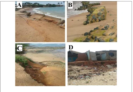
Evidence of sea erosion is dotted on the coast of Axim. The Upper Axim has a much more profound display of sea erosion activities as most of the sea defense originally built have collapsed (Figure 7). Others have their foundation exposed and are very weak posing a risk to people. Sea erosion has led to the complete destruction of houses and roads in Bariwa. Figure 8 shows the devastating effects of sea erosion in Axim. The rate of erosion has also been attributed to sand mining activites as beach sand is the most preferred in moulding of blocks for housing. This needs to be checked as climate change coupled with this anthropogenic activity will increase exposure and risk levels.
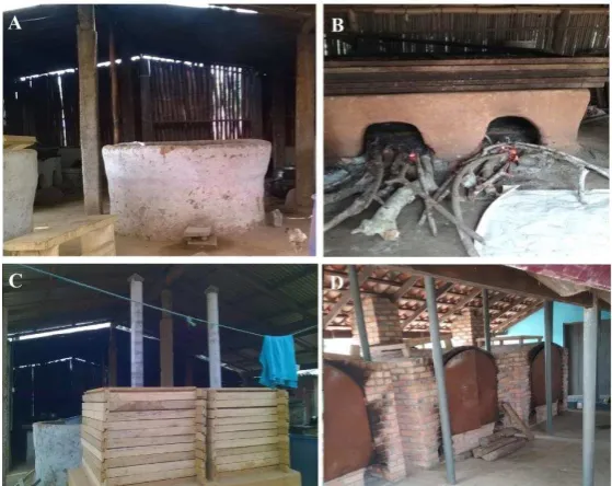
Figure 8 Impacts of erosion in Axim
(A) and (B) shows broken sea defence
(C) part of road being destroyed by sea waves (D) buildings destroyed by sea erosion
Fish infrastructure, households and business at risk
Vulnerability of Ovens
Climate change and its induced flooding pose a huge risk to fish processing infrastructures mainly due to the close proximity of ovens to the sea and other water bodies which leads to their washing away during flooding. The destruction of these ovens places a huge financial burden on fish processors and their households. The research sought to identify fish
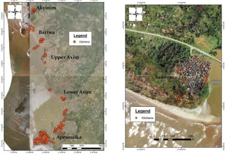
processing ovens because of their economic importance to the lives of people in Axim and Sanwoma. Over 177 fish processing kitchens were mapped, 52 in Sanwoma and 125 in Axim (Figure 9).
These are not the total number of kitchens in both communities as the research team was refused access to map some kitchens by owners. Ultimately, the number represents more than 80% of fish processing kitchens in these communities. Within Axim, most of the fish
processing kitchens were clustered in Apewosika accounting for 65% of the mapped kitchens. Lower Axim had the least kichens with about 8.8% mainly due to the the limited availability space. Upper Axim, Bariwa and Akyinim also had a few concentrated kichens mostly limited to headlands and landing beaches.
The kitchens house an average of about 6 ovens, with a total of about 766 ovens in these two communities. The least oven owned by a fish processing household was one (1) while large scale fish processors have more than 30 ovens which are housed in different kitchens. The dominant construction material of these ovens is mud erected in rectangular or circular
shapes (Figure 10 A, B). A typical single oven chamber has a height of 62cm and a weight of 140 cm with a life span of 2-3years. The cost of constructing a local oven made of mud
ranges from 20 to 40 Ghana cedis. Other types of ovens were also the Morrison stoves and the new improved ovens made of bricks (Figure 10 C, D).
The rectangular or chorkor ovens are the most widely used with only a hand full still with circular shaped ovens. Rectangular ovens are most preferred due to the quantity of fish that can be processed at a time. Its disadvantage is the amount of smoke emitted during
processing. The Morrison and Kosmos improved ovens were designed to solve this problem with the introduction of smoking chambers which local ovens lack. The chambers reduce the amount of smoke likely to be inhaled by the fish processor. Adapting to these improved ovens which are more environmentally friendly has been hindered by cost. The cost of
building improved ovens is higher than that of the local ovens. Constructing a Morrison oven, for example, can cost over 3,000 Ghana cedis.
Local rectangular ovens (chorkor ovens) are overlaid with large sieves or trays made of wooden edges and metal nets placed inside. A typical oven is usually overlaid by a number 6-10 sieve or trays. These have a capacity to accommodate over 160 kilos of fish. The average cost of acquiring a sieve is about 40 Ghana cedis. The wooden edges of the sieve makes them breakable with constant exposure to heat and elements of various weather conditions while the metal nets corrode as they are exposed to sea wind. The easy deterioration of sieves
places a burden on limited households’ income through constant repairs and replacements.
One favourable condition helping preserve these ovens and sieves are the shelters (kitchens) in which they are mostly housed. This reduces the impact of sea wind and flood waters on their rate of deterioration. Unfortunately the ovens’ vulnerability to floods is still high despite the availability of the shelters (kitchens) in which they are housed. This is because the shelters are constructed of wood and have no foundation or base which would prevent the free flow of flood waters into them. Vulnerability of fish processing ovens and kitchens is also associated with their distances away from water sources.
Figure 11 Distance of Kitchens from the Sea and with high water mark in Axim
Figure 12 Distance of Kitchens from the sea and distance of high water mark in Sanwoma
By considering distance from water bodies, elevation and type of building materials used for these ovens/kitchens, the vulnerability of ovens and kitchens in these two communities is clearly indicated. Thirty two (32%) percent of respondents interviewed have had their ovens flooded and destroyed by the sea or the Ankobra River. In the near future, such vulnerability levels and destructive power of sea and riverine flooding are likely to increase with rapid climate change. Inundation and destruction of these fish processing infrastructures means inundation of life activities of most women and households. Quantification of the cost of these ovens/kitchens is necessary to appreciate the magnitude of the risk and cost likely to be incurred by these fishing households. Estimated cost of ovens and sieves at risk is about 214,480 Ghana Cedis. This figure was derived based on average cost per oven by total ovens mapped plus cost per sieve by total sieves on the assumptions that kitchens mapped represent the total ovens in Axim and Sanwoma.
Vulnerability of fish processing households
Socio-economic characteristics of fish processing households are important to understand the overall vulnerability of the fish processing activities in these two communities. Household heads involved in fish processing interviewed had an average monthly income of 362 Ghana Cedis. Such income levels are relatively low considering high dependency in these
communities with an average household number of 4 people. Most of the household members are minors with a typical household having 4 members less than 18 years still under care. This places a huge burden on household heads to meet daily financial needs of dependents with little income generated from fish processing. Interview data shows 62% of the
respondents were solely dependent on fish processing without any diversified occupation. Engagement in other sources of income not related to the fishing industry is a way of increasing household resistance level and decreasing vulnerability. Those with a secondary occupation mostly were in petty trading for subsistence.
More than half of the interviewed respondents were able to save some of the little income generated with Rural Banks. The downside is the high rate of interest on loans charged by Rural Banks where rates can be well over 38% per annum. This deters most respondents from applying for loans in order to boost their fish processing business. Cooperatives tend to have lower interest rates than all other financial institutions in the country. But in spite of fishing cooperation associations in these communities, these associations had no financial standings to grant loans to members.
Most fish processing households believe their vulnerability levels are increasing with changing climate (Figure 13). The major reason ascribed to this increasing vulnerability is dwindling fish catch. Other non-climate related reasons given were high cost of
transportation and low prices received for smoked fish as the number of people engaged in the business has increased over the years. Considering the perishability of their product, they are compelled to sell at low prices to market women to meet their cost of production and make little revenue. In order to adapt to low incomes and increasing vulnerabilities, some strategies have been adopted by these fish processing households ranging from reducing food quantities previously consumed to others resorting to borrowing from friends and relatives to supplement low incomes for household expenditure.
Other fish related infrastructure
Assets and infrastructure supporting the fishing business are at risk to flooding and erosion. There are about four premix fuel stations in close proximity to the coast. Sheds used by fishermen for relaxation are also hihly at risk to sea erosion and flooding. This was one predominant structure along the beach. Another important fish infrastructure at risk is the ice factory in Lower Axim. It is the main source of ice for fishing boats in the community as it provides ice for preservation of fish both on and offshore.
Businesses at risk
Daily commuting of fishermen and women creates a large pool of ready buyers for the diverse businesses in Axim and Sanwoma. Getting the most of this available market has led to the surge of business centers within few meters of landing beaches. The main market of
their necessary basic needs ranging from food to financial services. The success of these activities is directly linked to the success of the fishing industry; thus, studying them helps to understand the overall risk the entire economy of these communities is largely to suffer due to climate change. Diverse business activities were identified in these communities (Figure 14).
Figure 14 Business in Axim (100 meters away from the sea) and Sanwoma at risk to sea level rise
Figure 15 Daily sales of some businesses in Axim and Sanwoma
Huge sales enjoyed by drinking pubs are more likely to be attributed to the male dominated nature of fishing businesses. Fishermen usually enjoy a few bottles of beer and other alcoholic beverages after long fishing trips. They also frequent these pubs in wait for next fishing expeditions which accounts for the high sales generation by these pubs. Food vendors make an average of 91 Ghana cedis, in spite of their huge customer base.
Mapping low risk zones for sitting fish processing infrastructures
Table 1 Risk levels within Axim
Risk Levels Risk Indices Area (m2) Percent
Low 0.6-0.8 1345476.96 30.94
Moderate 0.4-0.6 1975980.80 45.44
High 0.2-0.4 656548.46 15.09
Very High 0-0.2 370108.25 8.51
Total 4348114.50 100.00
Table 2 risk levels within Sanwoma
Risk Levels Risk Indices Area (m2) Percent
Low 0.6-0.8 - -
Moderate 0.4-0.6 147822.17 36.46
High 0.2-0.4 205230.27 50.62
Very High 0-0.2 52340.71 12.91
Total 405393.20 100.00
Figure 16 Risk zones in Axim community
Figure 17 Risk zones in Sanwoma
High risk zones cover the greatest part of the Sanwoma community with an area of
205,230.27m2, that is, 50.62% of the community. High risk zones in Sanwoma are heavily developed encompassing over 94% of structures while Axim has 39.8% of structures occupying this zone. In most advanced countries, high risk zones are areas with
developmental restrictions (Hubbard, 2012). In places where settlements already exist, the most appropriate measure employed is resettling to lower risk zones. The case in Axim and Sanwoma is the opposite as many developments are still ongoing close to the sea and
lagoons. This goes against risk control and management policies as sitting new developments in very high risk zones is not a choice (Environmental Agency, 2009). There is a need for constant monitoring by local planners in ensuring developments are restricted and controlled, if possible, demolished. Moderate and low risk areas cover approximately 76.38% of the entire Axim community.
In relation to sitting a fishing infrastructure for women, moderate and low risk zones are recommended. Unfortunately, low risk zones are too far from the coast where most fish processors reside. Distance is a factor which will affect patronage and can reduce the facility’s viability considerably. Moderate risk zones are therefore recommended for such infrastructure. This is because they are within a distance of over 300meters which is quite far from the sea, yet can easily be accessed. Very low risk zones have an average distance of 700 meters away from resident location of fish processors. Moderate risk zones cover 45.44% of the total land size of Axim and 36.46% for Sanwoma. In terms of statistical differences, moderate and low risk zones are not so much apart. They are also well beyond 200 meters of other water bodies as lagoons and rivers like low risk areas. In terms of physical
infrastructural developments. Any major developments within high risk zones will demand the demolishing of existing structures which will add to the cost of building fish processing infrastructure. Also, siting the infrastructure within this zone means posing less
environmental and health problems associated with such a facility to the people. Estimated number of people within this zone is less compared to high risk zones.
Another reason for the recommendation to site new fish processing infrastructure in moderate risk zones is because of accessibility. Most of the road network is clustered within the high and moderate risk zones. Low risk zones have fewer road networks as they are characterised by undulating landscapes. Building within slopes requires additional cost and technical expertise which are likely to affect budget allocated.
Short term flood mitigation strategies (Action Based)
In order to achieve an effective adaptation measure, there is a need for coordination among locals and government officials at district, regional and national levels. Short term mitigation strategies can be successful if they are cross sectorial and involve the full diversity of persons with social, economic, political, cultural and technical backgrounds. The longevity of these strategies is highly dependent on ownership of the measure, and for that matter local participation is necessary.
Climate change awareness among locals and government officials
Awareness creation is very important to communicate an issue as it allows one to mass following for the intended issue. One of its main purposes is to enhance behavioral change at governmental levels in incorporating climate change policies as a major variable for future planning for Axim and Sanwoma. At the community level, it will help conscientise indigenes about climate related issues as well as the need to help preserve coastal ecosystems and refrain from building physical structures close to the sea as they are prone to ruin in years ahead. To achieve this goal of awareness creation among stakeholders in Axim and
Sanwoma, a few activities are recommended with an expected cost of implementation. These activities should be undertaken with the help of local radio stations, National Commission for Civic Education and SFMP.
Recommended Activities:
Erect 4 sign posts close to lagoons/wetland.
Erect 10 sign post in areas where sand mining is intense.
Organize community video shows on climate change and impact.
Organize a 3day seminar for planners, Assembly men, builders and chiefs.
Table 3: Estimated cost of climate change awareness actions
Activities/ Items Unit cost Quantity/ Days/Units Cost (Ghana Cedis)
Distribution of T-shirts 25 500 7,500
Erection of sign posts 120 10 1,200
Restore coastal ecosystems (Lagoons and Wetlands) in Axim
One of the best ways to tackle the impact of sea level and floods in Axim and Sanwoma is through a natural measure. A natural measure such as restoration of coastal ecosystems provides a two way benefit to man and the natural environment. A restored lagoon and wetland will serve as breeding grounds for fishes to boost fish stocks at sea in this time of dwindling fish catch. Wetlands will help enhance the growth of calcareous animals as
extensive developments along Axim coast has led to their virtual extinction. It has the ability to serve as a natural shoreline defense as they will help in absorbing excess water either from intense rainfall or sea water in preventing floods. In addition, healthy wetlands will slow the intrusion rate of sea water inland to cause salinization of land and well water. It would also reduce exposure of structures to sea level rise.
In order to achieve this, itis essential that structures close to the lagoons are destroyed to allow landscape modelling to restore hydrological balance of the lagoons. Lagoons in Axim have to be cleaned through communal labour and efforts under the supervision of the District Assembly and Hen Mpoano. It is also important to create a wetland and lagoon management team which will be responsible for daily management of the wetland buffer. Their main job, initially, will be to replant mangrove species in the new zone. They will also serve as guards for the buffer, preventing access for at least 5years to ensure regrowth of mangrove on the wetland.
Activities/ Interventions:
Dredging the three lagoons in Axim
Landscape modification
Creating a buffer zone of 50meters
Table 4: Estimated cost on restoring coastal ecosystems
Activities/ Items Unit cost Quantity/ Days/Units Cost (Ghana cedis) Dredging of lagoons
Ensuring enforcement of planning building codes and coastal zone management laws
Enforcement of laws is one major problem facing the developmental agenda of most
MMDA’s. This is because of nepotism and nonpolitical will on the part of government
officials. A community based sea level rise watch must be created using Unit Committee Members, Assembly Men and Chief Fishermen. They will help in reporting people developing within wetlands and also those engage in sand wining activities. Activities/ Interventions:
Report any new development in the wetland buffer and 100m
Break any development within its first week
Prevent any activity within lagoons and wetland buffer zone
The cost of this activity should be financed by the district assembly through their internal generated funds and government subventions. This is to increase ownership of the and participation from the district assembly.
Improve household income levels and EMPLOYMENT opportunities
Increasing income levels of fishing households is of great importance as a measure of increasing resilient levels. This is achievable if fish processing households can get the most out of their products in monetary terms. The number of fish processors on the local market tends to increase supply of smoked fish which impacts negatively on price. To solve this problem, exportation to Europe and America is recommended; as in relative terms prices in these new markets are likely to be higher and will help improve incomes. Selling on
international markets needs processed fish meeting international food standards. This
demands the change of current fish processing ovens used by these local processors to much
improved ovens which will meet international standards. Morrison’s stove is being advocated
Activities/ Interventions:
Migration from local ovens to Morrison ovens
Training women in bakery, soap and Fante kenkey making as well as palm oil processing
Creating local cooperative groups for fish processing households
Table 5 Estimated cost on improving household income levels and opportunities
Activities/ Items Unit cost (Ghana cedis)
Quantity/ Days/Units Cost (Ghana cedis)
Bakery 250 100 25000
The main long term adaptation measure is resettlement of persons living within very high and high risk areas in both Axim and Sanwoma. It is better they relocate to preferably low risk zones or moderate risk areas. But in most local socities, the idea of relocation had always been met with strong resistance because people are akin and have developed a profoundness of their places of abode mainly as a result of social and cultural bonds shared with
neighbours. For relocation of persons in risky zones to be successful there is the need for a much coordinated approach involving locals, the government and other developmental agencies.
Table 6 Estimated cost on long term Adaptation measure
Activities/ Items Unit cost (Ghana Cedis)
Cost of resettlement 15,000 1,558 23.37
CONCLUSIONS
Vulnerability of fish processors in Axim and Sanwoma is increasing with increase in the frequency of sea inundation. Factors increasing vulnerability of fish processors are residing close to the sea and weak construction material of fish processing ovens as sea water easily floods their homes and ovens. Climate change also comes with dwindling fish catch which is affecting the quantity of fish processed for sale. This has a negative impact on incomes generated by fish processing households.
Creating awareness among locals and government officials is one way of addressing the situation. Awareness creation can enhance behavioral change at governmental levels in incorporating climate change policies as a major variable in future planning. At the
community level, it will help conscientise indigenes about climate related issues as well as the need to help preserve coastal ecosystems and refrain from building physical structures close to the sea as they are prone to damage. A natural measure such as revamping coastal ecosystems can provide a two way benefit to man and the natural environment. It also has the ability to serve as a natural shoreline defense as they will help in absorbing excess water either from intense rainfall or sea water in preventing floods
Enforcement of building codes and laws by planners and building inspectors in the community will help identify and prevent development within high risk zones. Lastly increasing income levels of fishing households is of great importance as a measure of increasing resilience. Ability to sell processed fish on international markets can help boost incomes and reduce price competition among fish processors. Selling on international
markets needs processed fish meeting international food standards. This demands the change of current fish processing ovens used by these local processors to much improved ovens
which will meet phytosanitary standards. Morrison’s stove is being advocated in this case.
Diversifying livelihood systems away from the fishing industry to other light industries such as bakery, soap making and palm oil processing is important to reduce shocks from
REFERENCES
Benson, C. (2009). Mainstreaming disaster risk reduction into development: Challenges and experience in the Philippines. Provention Consortium, Geneva-Switzerland.
Food and Agriculture Organization of the United Nations (2016). FAO soils portal. Accessed on 2 March 2016 on
http://www.fao.org/soils-portal/soil-survey/soil-classification/fao-legend/key-to-the-fao-soil-units/en/
Jongman, B., Winsemius, H. C., Aerts, J. C., de Perez, E. C., van Aalst, M. K., Kron, W., & Ward, P. J. (2015). Declining vulnerability to river floods and the global benefits of
adaptation. Proceedings of the National Academy of Sciences, 112(18), E2271-E22 Melillo, J. M., Richmond, T. T., & Yohe, G. W. (2014). Climate change impacts in the United States. Third National Climate Assessment.
Neumann, B., Vafeidis, A. T., Zimmermann, J., & Nicholls, R. J. (2015). Future coastal population growth and exposure to sea-level rise and coastal flooding-a global assessment. PloS one, 10(3), e0118571.
Nicholls, R. & Wong, P. (2007). Climate change 2007: Impacts, adaptation and vulnerability. Cambridge: Cambridge University Press.
Okyere, C. Y., Yacouba, Y., & Gilgenbach, D. (2013). The problem of annual occurrences of floods in Accra: an integration of hydrological, economic and political perspectives.
Theoretical and Empirical Researches in Urban Management, 8(2), 45.
Singh, B. (2013). Flood engulfs low-laying urban areas, people left in the lurch. Reterieved Feburary 21, 2015 from Times of India,
http://timesofindia.indiatimes.com/city/varanasi/Flood-engulfs-low-lying-urban-areas-people-left-in-the-lurch/articleshow/22110827.cms
Tanu, M. (2008). Seasonality of recession time and lag response to precipitation of the Ankobra and Pra rivers in Ghana, West Africa. 28th Conference on Hurricanes and Tropical Meteorology, Orlando, Florida.
Tiepolo, M. (2014). Climate change vulnerability in Southern African cities. Switzerland: Springer Climate.
Trenberth, K. (2011). Changes in precipitation with climate change. Climate Research , 47, 123-138.