The Honorable Donald L. Carcieri, former Governor, State of Rhode Island
U.S. Congressman Patrick Kennedy U.S. Congressman Jim Langevin U.S. Senator Jack Reed
U.S. Senator Sheldon Whitehouse
Rhode Island General Assembly
Chairwoman V. Susan Sosnowski, Senate Committee on Environment and Agriculture Chairman Arthur Handy, House Committee on Environment and Natural Resources
Rhode Island Ocean Special Area Management Plan (Ocean SAMP) Volume I
Adopted October 19, 2010
A management program of the Rhode Island Coastal Resources Management Council
Council Members
Michael M. Tikoian, Chairman* Paul E. Lemont, Vice Chairman* David Abedon*
Donald Gomez*
W. Michael Sullivan, RIDEM Raymond C. Coia
Bruce Dawson Robert G. Driscoll
(* Denotes Subcommittee Member)
Grover J. Fugate, Executive Director and Ocean SAMP Program Manager
Brian Goldman Legal Counsel Goldman Law Offices Smith Street
Acknowledgements for affiliation acronyms):
Michelle Armsby Carnevale, CRC/RISG Dave Beutel, CRMC
John Brown, NIT Barry Costa‐Pierce, RISG Teresa Crean, CRC/RISG Alan Desbonnet, RISG Rebecca Eith, CRC/RISG
Susan Farady, RWU School of Law and the RISG Legal Program Brian Goldman, for CRMC
Rick Greenwood, RIHPHC
Kate Haber, RWU School of Law and URI
Gwen Hancock, RWU School of Law and the RISG Legal Program Doug Harris, NIT
Leanna Heffner, URI GSO
Megan Higgins, RWU School of Law and the RISG Legal Program John Jensen, URI Archeology Group
Sue Kennedy, CRC/RISG Dawn Kotowicz, CRC/RISG
Rod Mather, URI Department of History Amber Neville, CRC/RISG
Pam Rubinoff, CRC/RISG Ella Sekatau, NIT
Ryan Smith, RWU School of Law and the RISG Legal Program Sarah Smith, CRC/RISG
Tiffany Smythe, CRC/RISG Charlotte Taylor, RIHPHC Jim Tobey, CRC
Chip Young, URI Coastal Institute
GIS guidance and support provided by the staff of the Environmental Data Center, Department Of Natural Resources Science at URI:
The CRMC gratefully acknowledges the extensive time, energy and thought which the following committed individuals Jennifer McCann, CRC/RISG Kathryn Moran, URI GSO Robert Buchsbaum, Massachusetts Audubon Society Jeremy Collie, URI GSO
Jonathan Garber, EPA/AED Candace Oviatt, URI GSO Osvaldo Sala, Brown University Caroly A. Shumway, BU
Deborah Crowley, Applied Science Associates, Inc. Lauren Decker, ASA
Steve Decker, Rutgers University Department of Environmental Sciences Vincent Elia, New Jersey Audubon Society
Lindsey Fields, URI GSO Robert Fogg, NJAS
Tony Fox, University of Aarhus, Denmark Deborah French McCay, ASA
David La Puma, NJAS Thomas Magarian, NJAS Anna Malek, URI GSO
Rod Mather, URI Department of History Scott McWilliams, URI CELS
Daniel Mendelsohn, ASA Jeff Mercer, URI GSO
Jeffrey Nystuen, University of Washington Applied Physics Laboratory Bryan Oakley, URI Department of Geosciences
Stephen Olsen, CRC/SG
Peter Scheifele, UCONN Bioacoustics Laboratory Ravi Sharma, URI DOE
Frank Thomsen, Centre for Environment, Fisheries & Aquaculture Science, UK Dave Ullman, URI GSO
Kristopher Winiarski, URI CELS
Research Finance and Support Team
Debra Bourassa, URI CELS Kate Manning Butler, CRC/RISG Sharon Clements, URI GSO
Charlotte Ferris, RWU School of Law and the RISG Legal Program Rhonda Kennedy, URI GSO
Charles Labash, URI CELS Amber Neville, CRC/RISG Gail Paolino, URI DOE
Michelle Armsby, CRC/RISG Bob Bowen, CRC
Sarah Smith, CRC/RISG Tiffany Smythe, CRC/RISG Chip Young, URI CI
CRMC Ocean SAMP Staff
Dave Beutel, Policy and Planning Dan Goulet, Policy and Planning
Laura Ricketson‐Dwyer, Public Educator and Information Coordinator Jeff Willis, Deputy Director
Federal Agency Assistance and Coordination
Allison Castellan, NOAA/OCRM Tom Chapman, FWS
Mel Coté, EPA/OEP Robert DeSista, ACOE Michael Elliott, ACOE Peter Holmes, EPA/WPS David Kaiser, NOAA/OCRM Edward LeBlanc, USCG Chris Tompsett, NUWC Erin Trager, BOEMRE Sue Tuxbury, NOAA/NMFS Rick Greenwood, RIHPHC
Fred Hashway, RIEDC Jared Rhodes, RISPP Ted Sanderson, RIHPHC Michael Sullivan, RIDEM Charlotte Taylor, RIHPHC
Technical Advisory Committees (Individual Chapters)
Ecology of the SAMP Region Technical Advisory Committee Stuart Findlay, Cary Institute of Ecosystem Studies Tim Gleason, EPA/AED
Allen Gontz, University of Massachusetts, Boston James O’Donnell, UCONN
Eric Schneider, RIDEM Caroly Shumway, BU
Barbara Sullivan‐Watts, Providence College Roman Zajac, University of New Haven
Global Climate Change Technical Advisory Committee Wenley Ferguson, STB
Tim Gleason, EPA/AED
Scott Mowery, NOAA National Oceanographic and Coastal Data Centers Eric Schneider, RIDEM
Kathleen Wainwright, TNC
Cultural and Historical Resources Technical Advisory Committee Jim Crothers, South County Museum
Pamela Gasner, Block Island Historical Society Pam Lyons, Charlestown Historical Society Marjory O’Toole, Little Compton Historical Society
Lori Urso, Pettaquamscutt Historical Society Museum & Library
Commercial and Recreational Fisheries Technical Advisory Committee Rick Bellavance, RIPCBA
Chris Brown, RICFA Jeremy Collie, URI GSO
Julie Crocker, NOAA NMFS Protected Resources Division Lanny Dellinger, RILA
Richard Fuka, RIFA Mark Gibson, RIDEM Richard Hittinger, RISAA Rob Hudson, STB Tricia Jedele, CLF Chris Littlefield, TNC Mike Marchetti, ENESA Greg Mataronas, SPFA Candace Oviatt, URI GSO Ted Platz, RIMA
John Pappalardo, NEFMC David Preble, NEFMC
Bill Silkes, Ocean State Aquaculture Association Laura Skrobe, RISG
Brad Spear, ASMFC David Spencer, CFRF John Torgan, STB Nicole Travisono, RIDEM Sue Tuxbury, NOAA/NMFS Kathleen Wainwright, TNC Wendy Waller, STB Russ Wallis, OSFA
Recreation and Tourism Technical Advisory Committee Mark Brodeur, RIEDC
George Cochran, RIMTA Michael Keyworth, RIMTA
Shelia McCurdy, Cruising Club of America John Rainone, RIPCBA
Evan Smith, NBCCVB Melissa Stanziale, RIDEM
Robin Wallace, Rhode Island State Yachting Committee
Marine Transportation, Navigation, and Infrastructure Technical Advisory Committee Paul Costabile, NMPA
Stephen Curtis, ProvPort Howard McVay, NMPA
Evan Matthews, Quonset Development Corporation Chris Myers, Interstate Navigation
Matt Wingate, NOAA
Renewable Energy Technical Advisory Committee Christopher Baxter, URI DOE
Phil Colarusso, EPA Ames Colt, RIBRWCT Tim Gleason, EPA/AED Annette Grilli, URI DOE
Evan Matthews, Quonset Development Corporation Walt Musial, NREL
Ken Payne, Rhode Island Office of Energy Resources Paul Roberti, Rhode Island Public Utilities Commission Michael Ryan, National Grid
Steve Textoris, BOEMRE Bob Thresher, NREL Dick West, (ret) U.S. Navy
Other Future Uses Technical Advisory Committee Tim Gleason, EPA
Eric Schneider, RIDEM Dan Sheehy, Aquabio, Inc. Caroly Shumway, BU Charles Yarish, UCONN
Existing Policies, Statutes and Regulations Technical Advisory Committee Ames Colt, RIBRWCT Jeff Broadhead, Washington County Regional Planning Council Paige Bronk, City of Newport
John Brown, NIT Chris Brown, RICFA
Alison Buckser, Rhode Island Chapter of the Sierra Club Charlie Cannon, Rhode Island School of Design Jeffry Ceasrine, Town of Narragansett Paul Costabile, NMPA
Vicki deAngeli, Jamestown Chamber of Commerce Lanny Dellinger, RILA
Julio DiGiando, Jamestown Town Council Denny Dillon, RIPCBA
Tina Dolen, Aquidneck Island Planning Commission Charlene Dunn, Charlestown Town Council Bernard Fishman, Rhode Island Historical Society Richard Fuka, RIFA
Michael Keyworth, RIMTA
John F. Killoy III, Rhode Island AFL‐CIO Karina Lutz, People's Power & Light Mike Marchetti, ENESA
Gregg Mataronas, SPFA Steve Medeiros, RISAA
Robert Mushen, Town of Little Compton Ray Nickerson, Town of South Kingstown Eleftherios Pavlides, Wind Power RI Project, RWU Margaret Petruny‐Parker, CFRF
Ted Platz, RIMA
David Prescott, Rhode Island Chapter of the Surfrider Foundation Michael Ryan, National Grid
Paul Sanroma, Rhode Island Wind Alliance Bill Silkes, Ocean State Aquaculture Association Evan Smith, NBCCVB
David Spencer, Atlantic Offshore Lobstermen’s Association Keith Stokes, Newport County Chamber of Commerce Larry Taft, Audubon Society of Rhode Island
Darlene Towne Evans, South Kingstown Chamber of Commerce Kathleen Wainwright, TNC
Russell Wallis, OSFA Wendy Waller, STB
Laurie White, Greater Providence Chamber of Commerce Jessica Dugan Willi, Block Island Tourism Council Ronald Wolanski, Town of Middletown
ASA: Applied Science Associates, Inc.
ASMFC: Atlantic States Marine Fisheries Commission
BOEMRE: U.S. Bureau of Energy Management, Regulation & Enforcement BU: Boston University
CLF: Conservation law Foundation
CFRF: Commercial Fisheries Research Foundation CRC: URI Coastal Resources Center
CRC/RISG: University of Rhode Island Coastal Resources Center/Rhode Island Sea Grant College Program CRMC: Rhode Island Coastal Resources Management Council
ENESA: Eastern New England Scallop Association
EPA/AED: U.S. Environmental Protection Agency/Atlantic Ecology Division EPA/OEP: U.S. Environmental Protection Agency/Office of Ecosystem Protection EPA/WPS: U.S. Environmental Protection Agency/Wetlands Protection Section FWS: U.S. Fish & Wildlife Service
NBCCVB: Newport and Bristol Counties Convention and Visitor’s Bureau NEFMC: New England Fisheries Management Council
NIT: Narragansett Indian Tribe NJAS: New Jersey Audubon Society
NMPA: Northeast Marine Pilots’ Association
NOAA: National Oceanographic and Atmospheric Administration
NOAA/NMFS: National Oceanographic and Atmospheric Administration/National Marine Fisheries Service NOAA/OCRM: National Oceanographic and Atmospheric Administration/Office of Ocean and Coastal Resource Management
NREL: National Renewable Energy Laboratory NUWC: U.S. Naval Undersea Warfare Center
Ocean SAMP: Rhode Island Ocean Special Area Management Plan OSFA: Ocean State Fishermen’s Association
RIBRWCT: RICFA Rhode Island Commercial Fishermen's Association RICFA: Rhode Island Commercial Fishermen's Association
RIDEM: Rhode Island Department of Environmental Management RIEDC: Rhode Island Economic Development Corporation RIFA: Rhode Island Fishermen’s Alliance
RIHPHC: Rhode Island Historical Preservation and Heritage Commission RILA: Rhode Island Lobstermen’s Association
RIMA: Rhode Island Monkfishermen’s Association RIMTA: Rhode Island Marine Trades Association RIPCBA: Rhode Island Party & Charter Boat Association RISAA: Rhode Island Saltwater Anglers Association RISG: Rhode Island Sea Grant College Program RISPP: Rhode Island Statewide Planning Program RWU: Roger Williams University
SPFA: Sakonnet Point Fishermen’s Association STB: Save The Bay
TNC: The Nature Conservancy UCONN: University of Connecticut URI: University of Rhode Island
5-4-2011 Approved Ocean SAMP Executive Summary Page 1 of 2
Executive Summary
1. Through the Ocean Special Area Management Plan (Ocean SAMP), the Rhode Island Coastal Resources Management Council (CRMC) commits itself to uphold both its obligations to preserve, protect, develop, and where possible, restore the coastal resources of the state for this and succeeding generations, and to ensure that the preservation and restoration of ecological systems shall be the primary guiding principle upon which environmental alteration of coastal resources will be measured, judged and regulated.
2. The waters off Rhode Island’s coasts have long served as an important and highly valuable environmental, economic and cultural hub for the people living in this region. The natural beauty of these offshore waters, along with its rich historic and cultural heritage, provides aesthetic, artistic, educational, and spiritual value and is part of the appeal that draws people to live, work, and play in Rhode Island. Rhode Island’s offshore waters are an ecologically unique region and host an interesting biodiversity of fish, marine mammals, birds, and sea turtles that travel throughout this region, thriving on its rich habitats, microscopic organisms, and other natural resources.
3. As a means to promote, protect, enhance, and honor these existing human uses and natural resources of Rhode Island, while encouraging appropriate marine-based economic development, and facilitating the coordination of state and federal decision making, the CRMC has produced the Ocean SAMP. Using the best available science and working with well-informed and committed resource users, researchers, environmental and civic organizations, and local, state and federal government agencies, the Ocean SAMP provides a comprehensive understanding of this complex and rich ecosystem as well as describes how the people living in this region have long used and depended upon these offshore resources. To fulfill the Council’s regulatory responsibilities, the Ocean SAMP lays out enforceable policies and recommendations to guide CRMC in promoting a balanced and comprehensive ecosystem-based management approach for the development and protection of Rhode Island’s ocean-based resources within the Ocean SAMP study area.
4. Since 1983 the CRMC has successfully applied marine spatial planning (MSP) to achieve ecosystem-based management along Rhode Island’s coastline. CRMC’s six existing SAMP’s, as well as the state’s water type designations, successfully apply MSP. Through the Ocean SAMP, CRMC builds on this success and applies this same MSP technique to effectively manage Rhode Island’s offshore waters.
5-4-2011 Approved Ocean SAMP Executive Summary Page 2 of 2
6. There is an increased demand for the potential placement of many structures and activities, including liquefied natural gas infrastructure, aquaculture, and artificial reefs, in Rhode Island’s offshore waters. However, the major driver for the development of the Ocean SAMP was the determination by the Rhode Island Office of Energy Resources in 2007 that investment in offshore wind farms would be necessary to achieve Governor Donald Carcieri’s mandate that offshore wind resources provide 15 percent of the state’s electrical power by 2020. In response, the CRMC proposed the creation of a SAMP as a mechanism to develop a comprehensive management and regulatory tool that would proactively engage the public and provide policies and recommendations for appropriate siting of offshore renewable energy.
7. The process to both develop the Ocean SAMP as well as establish policies and regulations is guided by goals and principles that were developed in coordination with the Ocean SAMP researchers and stakeholder group. The Ocean SAMP Goals highlight the commitment by CRMC to: foster a properly functioning ecosystem that is both ecologically sound and economically beneficial; promote and enhance existing uses; encourage marine-based economic development that considers the aspirations of local communities and is consistent with and complementary to the state’s overall economic development, social, and environmental needs and goals; and build a framework for coordinated decision-making between state and federal management agencies.
Chapter 1: Introduction
Table of Contents
100 Introduction... 2
110 The Rhode Island Coastal Resources Management Council’s Ocean Special Area Management Plan ... 3
120 Protecting and Preserving the Ocean SAMP Area... 5
130 Goals and Principles for the Ocean SAMP... 6
140 Ocean SAMP Study Area... 9
150 Origins of the Ocean SAMP... 11
160 The CRMC’s State and Federal Responsibilities... 13
160.1. The Existing Regulatory Framework for Offshore Development ... 14
160.2. Working with Municipalities and Federal and State Agencies ... 15
170 The Contents of the Ocean SAMP Document ... 17
180 Literature Cited ... 18
Section 100. Introduction
1. Rhode Island’s offshore waters are an ecologically unique region—the Rhode Island Sound and Block Island Sound ecosystems, which are shallow, near shore continental shelf waters, are located at the boundary of two bio-geographic provinces, the Acadian to the north (Cape Cod to the Gulf of Maine) and the Virginian to the south (Cape Cod to Cape Hatteras). The area is dynamically connected to Narragansett Bay, Buzzards Bay, Long Island Sound, and the Atlantic Ocean via the Inner Continental Shelf. While this unique positioning places this ecosystem at high risk of impacts from global climate change, this positioning also allows it to contain and host an interesting biodiversity of fish, marine mammals, birds, and sea turtles that travel throughout this region, thriving on its rich habitats, microscopic organisms, and other natural resources.
2. The natural beauty of these offshore waters, along with its rich historic and cultural heritage, provides aesthetic, artistic, educational, and spiritual value. This natural beauty is part of the appeal that draws people to live, work, and play in Rhode Island and adds to the quality of life within the area.
3. The waters off Rhode Island’s coasts have long served as an important and highly valuable environmental, economic and cultural hub for the people of this region. Commercial and recreational fishing, one of the oldest and most widespread human uses of the area, has sustained Rhode Island coastal communities by providing jobs to fishermen and supporting businesses and industries, as well as food for local consumption or export throughout the United States and overseas. Recreational fisheries support businesses and families throughout Rhode Island and are a key element of the region’s recreation and tourism economy. Other recreational and tourism activities such as boating, sailing, diving, wildlife viewing, or shore-based activities such as surfing or beach going, have not only provided enjoyment but also have generated significant economic benefits for the state of Rhode Island.
4. Rhode Island’s offshore waters are part of the nation’s Marine Transportation System, which is the network of all navigable waterways, vessels, operators, ports, and intermodal landside connections facilitating the marine transport of people and goods in the United States.
Section 110. The Rhode Island Coastal Resources Management Council’s Ocean Special Area Management Plan
1. The Rhode Island General Assembly mandates the Rhode Island Coastal Resources Management Council (CRMC) to preserve, protect, develop, and where possible, restore the coastal resources of the state for this and succeeding generations through comprehensive and coordinated long range planning and management designed to produce the maximum benefit for society from these coastal resources; and that the preservation and restoration of ecological systems shall be the primary guiding principle upon which environmental alteration of coastal resources will be measured, judged and regulated [R.I.G.L. § 46-23-1(a)(2)]. To more effectively carry out its mandate, the CRMC has established use categories for all of the state’s waters out to three nautical miles from shore. The Rhode Island Coastal Resource Management Program (RICRMP) is approved as part of the national Coastal Zone Management Program under the federal Coastal Zone Management Act of 1972, 16 U.S.C. § 1451 et. seq.
2. The Ocean Special Area Management Plan (Ocean SAMP) is the regulatory, planning and adaptive management tool that CRMC is applying to uphold these regulatory responsibilities in the Ocean SAMP study area. Using the best available science and working with well-informed and committed resource users, researchers, environmental and civic organizations, and local, state and federal government agencies, the Ocean SAMP provides a comprehensive understanding of this complex and rich ecosystem. The Ocean SAMP also documents how the people of this region have used and depended upon these offshore resources for subsistence, work, and play, and how the natural wildlife such as fish, birds, marine mammals and sea turtles feed, spawn, reproduce, and migrate throughout this region, thriving on the rich habitats, microscopic organisms, and other natural resources. To fulfill the Council’s mandate, the Ocean SAMP lays out enforceable policies and recommendations to guide CRMC in promoting a balanced and comprehensive ecosystem-based management approach to the development and protection of Rhode Island’s ocean-based resources within the Ocean SAMP study area as defined in section 130. The Ocean SAMP successfully fulfills its original stated objectives as summarized below in Section 150.
3. Ocean SAMP policies and recommendations build upon and refine the CRMC’s existing regulations presented in the RICRMP. The policies, standards, and definitions contained in the RICRMP for Type 4 waters within the Ocean SAMP boundary, specifically from the mouth of Narragansett Bay seaward, between 500 feet offshore and the 3-nautical mile state water boundary, are herby modified. In addition, RICRMP Sections 300.3 and 300.8 and the 1978 Energy Amendments are hereby superseded within the Ocean SAMP study area.
vitality of Rhode Island fisheries. Aquaculture leases shall be considered if the Council is satisfied there will be no significant adverse impacts on the traditional fishery. In addition, CRMC shall work to promote the maintenance and improvement of good water quality within the Type 4 waters (RICRMP Section 200.4).
5. As with the six existing Rhode Island SAMPs and CRMC’s water type designations, CRMC implements the marine spatial planning (MSP) process to achieve ecosystem-based management (EBM) for the entire Ocean SAMP region. For the purposes of the Ocean SAMP, the CRMC adopts the definition of EBM put forth in the “Scientific Consensus Statement on Marine Ecosystem-Based Management” (McLeod et al. 2005), which defines EBM as “an integrated approach to management that considers the entire ecosystem, including humans. The goal of EBM is to maintain an ecosystem in a healthy, productive and resilient condition that provides the services humans want and need.”1 Ecosystems are places and marine spatial planning (MSP) is the process by which ecosystem-based management is organized to produce desired outcomes in marine environments. Since 1983 the CRMC has successfully applied MSP to achieve EBM along Rhode Island’s coastline.
6. The Ocean SAMP is a tool for implementing adaptive management. Adaptive management is a systematic process for continually improving management policies and practices by learning from the outcomes of previously employed policies and practices. Adaptive management requires careful implementation, monitoring, evaluation of results, and adjustment of objectives and practices. Adaptive management usually allows more reliable interpretation of results, and leads to more rapid learning and better management. To this end, CRMC will establish several mechanisms to ensure that the Ocean SAMP is implemented using this management approach. See Chapter 11, The Policies of the Ocean SAMP, for more details.
7. Through the Ocean SAMP process, much research has been conducted in the Ocean SAMP area by University of Rhode Island scientists and partners, resulting in a great deal of new data and information. The results of these research projects are summarized and/or referenced, as appropriate, in the Ocean SAMP document, and are detailed in a series of technical reports included in the Ocean SAMP Appendices. Datasets associated with these studies are being compiled at the Pell Library at the University of Rhode Island Graduate School of Oceanography, and will be available for public use through the library.
1
Section 120. Protection and Preservation within the Ocean SAMP area
1. Since its establishment in 1971, the CRMC has had the authority to manage and plan for the preservation of the coastal resources of the state. For Type 4 (multipurpose) waters, the CRMC’s policy is to achieve a balance among diverse activities while preserving and restoring ecological systems. Consistent with this goal, the Ocean SAMP designates Areas of Particular Concern and Areas Designated for Preservation.
2. The Council recognizes that there are many cultural, social, and environmental areas within the Ocean SAMP study area that merit protection. To this end, the Council designates portions of the Ocean SAMP study area as Areas of Particular Concern. These Areas of Particular Concern have been identified through the Ocean SAMP process and include: areas with unique or fragile physical features, or important natural habitats; areas of high natural productivity; areas with features of historical significance or cultural value; areas of substantial recreational value; areas important for navigation, transportation, military and other human uses; and areas of high fishing activity. For example, glacial moraines within the Ocean SAMP area have been designated as Areas of Particular Concern because they are important habitat areas for fish due to their relative structural permanence and structural complexity. For a more detailed description of these areas and policies, see Chapter 11, The Policies of the Ocean SAMP.
Section 130. Goals and Principles for the Ocean SAMP
1. Using the best available science and working with well-informed and committed resource users, researchers, environmental and civic organizations, and local, state and federal government agencies, the Ocean SAMP will serve as the regulatory, planning and adaptive management tool to uphold CRMC’s regulatory responsibilities and promote a balanced and comprehensive ecosystem-based management approach to the development and protection of Rhode Island’s ocean-based resources within the Ocean SAMP study area.
2. CRMC integrates climate concerns and adaptation and mitigation responses into relevant policies and plans. It is the intent of the Ocean SAMP to contribute to the mitigation of, and adaptation to, global climate change as well as to facilitate coordination mechanisms between state and federal agencies and the people of Rhode Island. CRMC believes that with advanced planning, the harm and costs associated with these potential impacts can be reduced and may be avoided.
3. The following goals require engaging a well-informed, well-represented and committed public constituency to work with the Ocean SAMP project team to better understand the Ocean SAMP issues and the ecosystem, and provide input on Ocean SAMP policies and recommendations. Throughout the entire development of the Ocean SAMP document, the CRMC has been committed to engaging all sectors of the public through an extensive public process. For more information on this process, see Payne (2010), included in the Ocean SAMP Appendices.
4. The goals for the Ocean SAMP are to:
a. Foster a properly functioning ecosystem that is both ecologically sound and economically beneficial. Restore and maintain the ecological capacity, integrity, and resilience of the Ocean SAMP’s biophysical and socio-economic systems. Conduct research to better understand the current status of the natural resources, ecosystem conditions, and the implications of various human activities. Set standards within the SAMP document to protect and where possible restore and enhance natural resources and ensure that impacts from future activities are avoided and, if they are unavoidable, are minimized and mitigated. Establish monitoring protocols to evaluate the consequences of decisions and adapt management to the monitoring results.
c. Encourage marine-based economic development that considers the aspirations of local communities and is consistent with and complementary to the state’s overall economic development, social, and environmental needs and goals. This development should draw upon and be inspired by the beauty and quality of the environs, including the protection and enhancement of maritime activities, marine culture and a sense of place. Through the development of coastal decision-making tools, with accompanying standards and performance measures, determine appropriate and compatible roles for future activities within the study area, including offshore renewable energy infrastructure.
d. Build a framework for coordinated decision-making between state and federal management agencies. Engage federal and state agencies in all phases of the Ocean SAMP process to ensure that all appropriate regulatory requirements are integrated into the process. Ensure that neighboring states of New York, Connecticut, and Massachusetts are informed of all major actions. This coordination will allow for the sharing of technical information across all sectors, enhance management of these coastal ecosystems, and streamline the permitting process where and if appropriate.
5. The principles guiding Ocean SAMP design and development are to:
a. Develop the Ocean SAMP document in a transparent manner. Transparency guides the development of all documents and procedures related to the Ocean SAMP project. Project activities and phases are designed to be easily understandable to the general public. Accurate information must be made available to the public in an appropriate and timely manner.
b. Involve all stakeholders. Targeted efforts ensure opportunity is available for all stakeholders to have access to the Ocean SAMP planning process as early as possible. Stakeholder participation ensures that a broad range of issues, concerns, and creative ideas, are heard and examined throughout the SAMP process.
c. Honor existing activities. The Ocean SAMP area is a highly used and biologically and economically valuable place, with major uses such as fishing, recreation and tourism, transportation, and military activities. These, along with the area’s biology and habitat, must be understood, and highly regarded, and respected as decisions for the incorporation of future activities are determined.
gathering information on baseline resource conditions,2 potential environmental and economic impacts, and potential mitigation measures.
e. Establish monitoring and evaluation that supports adaptive management. Incorporating monitoring and evaluation in the Ocean SAMP will contribute towards implementing a systematic process for continually improving management policies and practices in an environment exposed to constant change. The SAMP process is flexible enough to react to such changes and allow plans to be revised in due course. A strong stakeholder process, coordination among federal and state regulatory agencies, and a transparent, monitoring and evaluation mechanism ensures this activity. See Section 1130 for further discussion of implementing the Ocean SAMP through adaptive management.
2
Section 140. Ocean SAMP Study Area
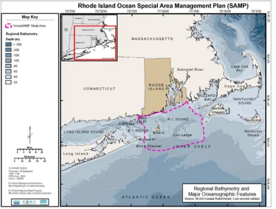
1. The Ocean SAMP study area boundary includes approximately 1,467 square miles (3,800 square kilometers) of portions of Block Island Sound, Rhode Island Sound and the Atlantic Ocean. The study area begins 500 feet from the coastline in state waters, from the mouth of Narragansett Bay seaward (out to three nautical miles), and all federal waters within the boundary. The study area, which is an irregularly shaped polygon, is encompassed by a box represented by the coordinates listed below. See Figure 1.1 for a more detailed map:
North: 41.497420° South: 40.912180° West: -71.907426° East: -70.848987°
The study area abuts the state waters of Massachusetts, Connecticut and New York.
2. This area was selected as the Ocean SAMP study area because the natural and human activities that take place in these offshore waters have a reasonable foreseeable effect on the people of Rhode Island, and conversely, human activities also impact the Ocean SAMP ecosystem. A similar boundary was selected by the U.S. Army Corps of Engineers in 2003 as it implemented an Environmental Impact Statement for the selection of dredge disposal sites (Long-Term Dredged Material Disposal Site Evaluation Project Alternative
Site Screening Report) and by the state of Rhode Island to determine potential wind
energy infrastructure sites (RIWINDS Phase I: Wind Energy Siting Study document produced for the Rhode Island Office of Energy Resources in April 2007). Therefore, some relevant information had already been collected for this study area prior to project initiation. In addition, the distance from the Rhode Island coastline to the furthest offshore boundary – 30 miles – is appropriate since AC cables, which transport electricity, are cost effective at up to 20 miles from shore.
3. Although Block Island is part of the Ocean SAMP study area, for the purpose of this document, Block Island land-based activities under the CRMC jurisdiction, Great Salt Pond, and activities 500 feet seaward of mean high water are regulated using CRMC’s existing regulatory program described in the RICRMP.
Section 150.Origins of the Ocean SAMP
1. In 2005, the CRMC recognized that the uses of marine resources in Rhode Island were intensifying; that optimizing the potential of this intensification would require intentional action driven by design rather than accident; and that needed intentional actions are collaborative in nature. The Rhode Island General Assembly mandated the CRMC to develop a new plan, the Marine Resources Development Plan (MRDP), to meet these new demands while protecting the natural ecosystem. The plan is aimed at improving the health and functionality of Rhode Island’s marine ecosystem, providing for appropriate marine-related economic development; and promoting the use and enjoyment of Rhode Island’s marine resources. Central to the MRDP is the premise that better results are achieved when expectations are clear and when parties work together. The MRDP is structured around existing CRMC authority and builds on the CRMC’s leadership in water-use zoning and special area management planning. SAMPs, which are guided by the MRDP, are ecosystem-based management strategies that are consistent with the Council's legislative mandate to preserve and restore ecological systems. The CRMC coordinates with local municipalities, as well as government agencies and community organizations, to prepare the SAMPs and implement the management strategies.
2. In 2006, through the Northeast Regional Ocean Council (NROC), the CRMC played a leadership role in the effort to engage the four southern states – New York, Connecticut, Rhode Island, and Massachusetts - in the initial phase of creating a multi-state SAMP. The Southern New England/New York Ocean Council working group was thus formed to prioritize issues (natural hazards, healthy ecosystems, marine transportation, and energy) requiring coordination among the four states and research mechanisms to enhance shared resources. Although a multi-state SAMP was never developed, this working group became officially recognized as the southern representation for the gubernatorial appointed NROC.
Section 160. The CRMC’s State and Federal Responsibilities
1. The CRMC is mandated to uphold all applicable sections of the federal Coastal Zone Management Act of 1972 (CZMA). The CZMA requires that the CRMC provide for the protection of natural resources within the coastal zone, including wetlands, floodplains, estuaries, beaches, dunes, barrier islands, and fish and wildlife and their habitat, and must manage coastal development to improve, safeguard, and restore the quality of coastal waters, and protect existing uses of those waters. The CRMC must develop management plans that give full consideration to ecological, cultural, historic, and aesthetic values, as well as needs for compatible economic development. SAMP’s are identified in the CZMA as effective tools to meet this mandate (16 U.S.C. § 1456b).
a.
2. The Ocean SAMP assists CRMC in upholding its mandate to preserve the state’s coastal resources on submerged lands in accordance with the public trust. As stated in Article 1, §17 of the Rhode Island Constitution, applicable statutes, and restated in the RICRMP, the state maintains title in fee to submerged lands below the high water mark, and holds these lands in trust for the use of the public, preserving public rights which include but are not limited to fishing, commerce, and navigation in these lands and waters. Rhode Island public trust resources are defined in RICRMP as the tangible physical, biological matter substance or systems, habitat or ecosystem contained on, in or beneath the tidal waters of the state, and also include intangible rights to use, access, or traverse tidal waters for traditional and evolving uses including but not limited to recreation, commerce, navigation, and fishing.
3. The CZMA finds that in order for the CRMC to uphold this mandate, it must actively participate in all federal programs affecting such resources and, wherever appropriate, develop state ocean resource plans as part of its federally approved coastal zone management program (16 U.S.C. § 1451).
4. The CRMC is the state authority for federal consistency under the CZMA (16 U.S.C. § 1456). Federal consistency requires federal agencies to alter projects to be consistent with state coastal management program policies. In addition, the statute requires non-federal applicants for non-federal authorizations and funding to be consistent with enforceable policies of state coastal management programs. A federal agency also has a statutory responsibility to provide neighboring or impacted states with the opportunity to review federal agency activities with coastal effects occurring wholly within the boundary of another state if that state has been approved for interstate consistency. For further information on federal consistency, see 15 CFR 930 et seq.
160.1. The Existing Regulatory Framework for Offshore Development
1. The following is a summary of the existing regulatory framework for offshore development. For a more detailed description of applicable regulations, see Chapter 10: Existing Statutes, Regulations, and Policies.
2. The CRMC currently has jurisdiction for offshore projects within Rhode Island state waters which would fall under the applicable provisions of the RICRMP and Management Procedures. In addition to a Council permit, a successful applicant will also need to obtain a lease of the state’s submerged lands. The leasing process is subsequent to the Council permit process, and to be eligible, an applicant will have to not only have the Council permit but will need the applicable federal, state and local permits as well as being identified as a preferred vendor by the R. I. Department of Administration.
3. For offshore wind infrastructure, the Federal jurisdiction is very complex but essentially falls onto two federal departments depending on location. In state waters, the primary permitting entity is the U.S. Army Corps of Engineers. In federal waters the primary permitting agency is the Bureau of Ocean Energy Management, Regulation, and Enforcement of the Department of Interior (BOEMRE), previously known as the U.S. Minerals Management Service (MMS). The recently released Bureau of Ocean Energy Management, Regulation, and Enforcement regulation recognizes the Ocean SAMP process with the following reference: "Two States—New Jersey and Rhode Island—are well along in planning efforts that will help to determine appropriate areas of the Outer Continental Shelf for development, and MMS has been an active partner with those States. Such efforts—supported by MMS environmental study and technical research initiatives, as well as the Coordinated OCS Mapping Initiative mandated by Energy Policy Act of 2005—will contribute significantly as MMS implements this final rule" (MMS 2009, 19643).
4. The Bureau of Ocean Energy Management, Regulation, and Enforcement also has the authority to issue leases for other forms of offshore renewable energy development such as hydrokinetic projects. Hydrokenetic projects, such as wave or tidal energy, require approval from the Federal Energy Regulatory Commission (FERC), which has exclusive jurisdiction to issue licenses for hydrokinetic projects under Part I of the Federal Power Act (16 USC § 791 et seq.) and issue exemptions from licensing under Section 405 and 408 of the Public Utility Regulatory Policies Act of 1978 (16 U.S.C. § 2601 et seq.) for the construction and operation of hydrokinetic projects on the Outer Continental Shelf. However, no FERC license or exemption for a hydrokinetic project on the OCS shall be issued before the Bureau of Ocean Energy Management, Regulation, and Enforcement issues a lease, easement, or right-of-way. For more information see Chapter 10, Existing Statutes, Regulations, and Policies and Chapter 8, Renewable Energy and Other Offshore Development.
promulgating this rule, the states of Delaware, New Jersey, and Rhode Island have conducted competitive processes and have selected companies to develop wind resources on the OCS. We believe that the pre-existing state processes are relevant to the competitive processes that MMS is required to conduct following approval of this rule. We intend to do so by using a competitive process that considers, among other things, whether a prospective lessee has a power purchase agreement or is the certified winner of a competitive process conducted by an adjacent state. We also may consider a similar approach to recognize the winners of competitions held by states in the future. There is additional discussion of this issue in our explanation of multiple-factor bidding provided in the next section" (MMS 2009, 19663).
6. Each federal process (i.e. U.S. Army Corps of Engineers and Bureau of Ocean Energy Management, Regulation, and Enforcement), depending on the resources encountered by a project in Rhode Island’s offshore waters, brings to bear a series of other federal regulations and processes.
160.2. Engaging Stakeholders
1. Ocean SAMP development and implementation depends on collaboration among and engagement by all stakeholders. Stakeholders are defined as government, citizens, civic and environmental organizations, resource users, and the private sector. The Ocean SAMP established a framework that engaged all major stakeholders. Major aspects of this stakeholder involvement include the following:
a. Ocean SAMP Stakeholder Group: From the outset, the Ocean SAMP stakeholder group has been an integral part of both determining the scope and contents of the document as well as refining the described policies. New research and findings were shared and developed in coordination with the stakeholders as a mechanism to ground truth and enhance findings. The Ocean SAMP goals and principles upon which the Ocean SAMP was produced were refined and approved by the stakeholders. Through a web site, list serve, and monthly meetings, the Ocean SAMP stakeholder process provided the public with an opportunity to stay up to date on current research, learn about Rhode Island’s offshore waters, ask questions and express concerns, as well as engage in the process of determining chapter scope and content (Payne 2010).
b. Technical Advisory Committees: CRMC established a Technical Advisory Committee (TAC) for each Ocean SAMP chapter. The TAC was made up of scientists, government agency representatives, and resource users with expertise in the chapter topic. The purpose of the TAC was to provide expert advice on the contents and scope for each chapter. TAC members assisted CRMC in refining and enhancing the chapters.
Task Force met periodically to discuss the science and the research as well as provide advice.
d. Federal and State Agency Coordination: CRMC engaged federal and state agency representatives to help determine and respond to the scope of the Ocean SAMP document. This constant engagement ensured that the Ocean SAMP will help to fulfill many of the regulatory requirements for each of these agencies as well as identified appropriate coordination mechanisms among these agencies that assist in future decision making.
Section 170. The Contents of the Ocean SAMP Document
1. The chapters that follow provide detailed findings of fact that describe the physical, biological and social aspects of the Ocean SAMP study area. This information comes from the best available science. When existing data did not exist - for example to better understand the physical oceanography, human uses of the study area by commercial mariners, recreational boaters and commercial and recreational fishermen - the CRMC, in coordination with the University of Rhode Island, implemented research to collect this necessary information.
2. Ocean SAMP policies and regulatory standards presented in this document represent actions the CRMC will take to uphold its regulatory responsibilities mandated to them by the Rhode Island General Assembly and the federal Coastal Zone Management Act to achieve the Ocean SAMP goals and principles described above. Policies presented for cultural and historic resources, fisheries, recreation and tourism, and marine transportation promote and enhance existing uses and honor existing activities (Goal b, Principle c). Ecology, global climate change, and other future uses information and policies provide a context for basing all decisions on the best available science, while fostering a properly functioning ecosystem that is both ecologically sound and economically beneficial (Goal a, Principle d). Renewable energy and offshore development policies and regulatory standards ensure there is a rigorous review for all ocean development so that the Council meets its public trust responsibilities.
Section 180. Literature Cited
ATM. 2007. RI Winds Summary Report, Applied Technology and Management for RI Office of Energy Resources, Providence, RI. Available online at:
http://www.energy.ri.gov/documents/renewable/RIWINDS_RANKING.pdf. Last accessed March 15, 2010.
Battelle. 2003. Final Report, Task 10.4 Alternative Site Screening Report. June 2003.
McLeod, K. L., J. Lubchenco, S. R. Palumbi, and A. A. Rosenberg. 2005. Scientific Consensus Statement on Marine Ecosystem-Based Management. Signed by 221 academic scientists and policy experts with relevant expertise and published by the Communication
Partnership for Science and the Sea at http://compassonline.org/?q=EBM.
MMS. 2009. “Renewable Energy and Alternate Uses of Existing Facilities on the Outer
Continental Shelf; Final Rule.” Federal Register, April 29, 2009, 74(81): 19638-19871.
5-4-2011 Approved Ocean SAMP Chapter 2 Page 1 of 134
Chapter 2: Ecology of the Ocean SAMP Region
Table of Contents
List of Figures... 3
List of Tables ... 5
200. Introduction... 6
210. Geological Oceanography ... 12
220. Meteorology ... 20
220.1. Wind ... 20 220.2. Storms ... 22
230. Physical Oceanography ... 24
230.1. Waves... 27 230.2. Tides and Tidal Processes... 27 230.3. Hydrography... 30 230.3.1. Temperature... 30 230.3.2. Salinity ... 33 230.3.3. Stratification... 36 230.4. Circulation ... 39 230.4.1. Block Island Sound... 42 230.4.2. Rhode Island Sound ... 45
240. Chemical Oceanography ... 48
240.1. Nutrients... 48 240.2. Toxins ... 50
250. Biological Oceanography... 54
5-4-2011 Approved Ocean SAMP Chapter 2 Page 2 of 134
250.2.1.1. Block Island Sound... 77 250.2.1.2. Rhode Island Sound ... 78 250.3. Fishes ... 79 250.4. Marine Mammals ... 87 250.4.1. Cetaceans... 87 250.4.2. Pinnipeds ... 97 250.5. Sea Turtles ... 98 250.6. Avifauna ... 100
260. Emerging Issues ... 110
260.1. Native Species Explosions ... 110 260.2. Invasive species ... 110 260.3. Marine Diseases ... 111
270. Policies and Standards... 113
270.1 General Policies ... 113 270.2 Regulatory Standards ... 114
280. Literature Cited ... 117
5-4-2011 Approved Ocean SAMP Chapter 2 Page 3 of 134
List of Figures
Figure 2.1. General geographic layout, basic bathymetry, and major features of the Ocean SAMP area... 7
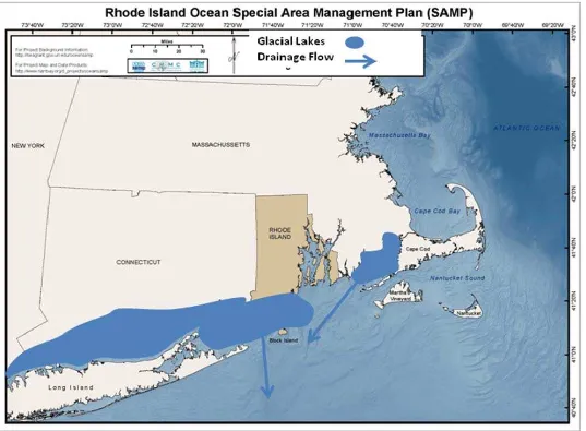
Figure 2.2. Approximate location of major glacial lakes and direction of drainage flows... 13
Figure 2.3. Location of glacial moraines in the Ocean SAMP area. ... 15
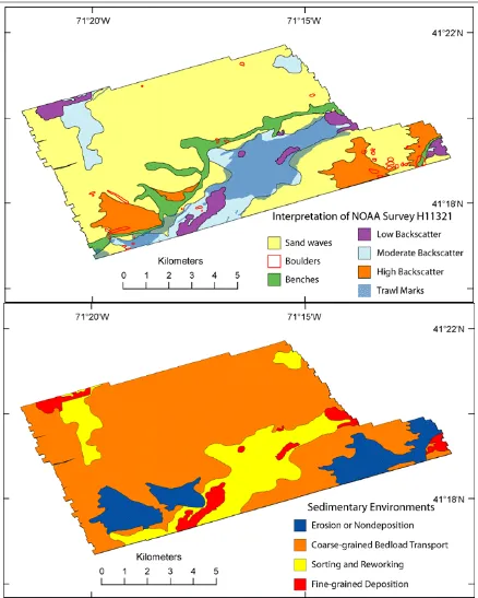
Figure 2.4. Bottom characteristics in a section of Rhode Island Sound. ... 18
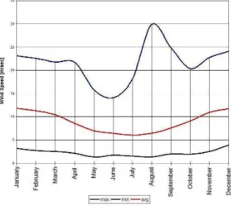
Figure 2.5. Average annual, average maximum, and average minimum wind speeds over the Ocean SAMP area... 21
Figure 2.6. Hurricane tracks where the eye moved over Rhode Island ... 22
Figure 2.7. Northern cold water currents, southern warm water currents, and Gulf Stream warm core rings entering the Ocean SAMP area... 26
Figure 2.8. Water current velocities in Block Island Sound ... 29
Figure 2.9. MARMAP water temperature data for all stations located within the Ocean SAMP area... 31
Figure 2.10. Seasonal water temperatures at sea surface, 20 m depth, and seafloor in the Ocean SAMP area ... 32
Figure 2.11. Average annual surface and bottom temperatures in Block Island Sound ... 33
Figure 2.12. Seasonal water salinities at various depths in the Ocean SAMP area ... 35
Figure 2.13. Average annual surface and bottom salinity at a station in Block Island Sound ... 38
Figure 2.14. Surface water salinity. ... 38
Figure 2.15. Differences in tidal circulation velocities between Rhode Island Sound (RIS) and Block Island Sound (BIS) ... 40
Figure 2.16. Hypothesized water flow at surface and at depth in the Ocean SAMP area ... 41
Figure 2.17. Summary of currents and hydrography in the Ocean SAMP area ... 422
Figure 2.18. Seasonal volume transport from Block Island Sound into Long Island Sound... 43
5-4-2011 Approved Ocean SAMP Chapter 2 Page 4 of 134
Figure 2.20. Seasonal, tidally averaged volume transport between Narragansett Bay and Rhode Island Sound... 47
Figure 2.21. Dredged materials disposal sites, and location of the North Cape oil spill... 52
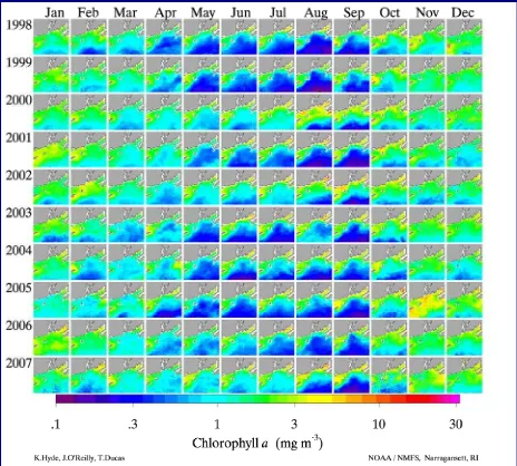
Figure 2.22. Monthly averaged chlorophyll a concentrations in the Ocean SAMP area ... 59
Figure 2.23. Ichthyoplankton abundance at the mouth of Narragansett Bay/Rhode Island Sound ... 65
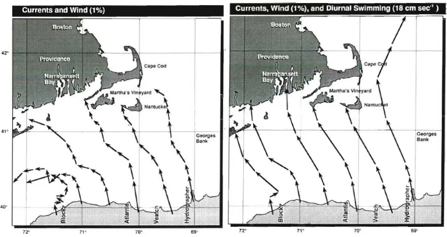
Figure 2.24. Lobster larval transport from the edge of the Continental Shelf into Rhode Island Sound and Block Island Sound ... 66
Figure 2.25. Benthic geological environments in a select portion of Block Island Sound... 72
Figure 2.26. Benthic surface roughness in the Ocean SAMP area ... 74
Figure 2.27. Seasonal composition of major fish and invertebrate species in the Ocean SAMP area... 83
Figure 2.28. Trawl catches at Whale Rock ... 84
Figure 2.29. Rate of increase/decrease of species collected at Whale Rock ... 84
Figure 2.30. Annual mean abundance of nine species collected at Whale Rock... 85
Figure 2.31. Community metrics for long term trawl samples collected at Whale Rock... 86
Figure 2.32. Modeled seasonal relative abundance patterns of right whales, humpback whales, and fin whales in the Ocean SAMP area, ... 90
Figure 2.33. Modeled seasonal relative abundance patterns of harbor porpoise, common dolphin, and Atlantic white-sided dolphin in the Ocean SAMP area ... 94
Figure 2.34. Harbor seal haul-out sites. ... 98
Figure 2.35. Modeled seasonal relative abundance patterns of leatherback sea turtles in the Ocean SAMP area... 100
Figure 2.36. Seasonality of avifauna in the Ocean SAMP area... 103
Figure 2.37. Potential use of the Ocean SAMP area by diving ducks ... 104
Figure 2. 38. Seasonal use of the Ocean SAMP area by gulls, loons and shearwaters ... 106
Figure 2.39. Most abundant waterbirds nearshore and offshore in the Ocean SAMP area ... 107
5-4-2011 Approved Ocean SAMP Chapter 2 Page 5 of 134
List of Tables
Table 2.1. Nutrient concentrations measured in Block Island Sound... 49
Table 2.2. Nutrient concentrations measured in Rhode Island Sound... 50
Table 2.3. Comparison of primary production in Ocean SAMP waters with nearby ecosystems 57
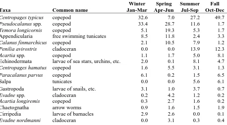
Table 2.4. MARMAP Ocean SAMP area zooplankton data collected since 1978... 62
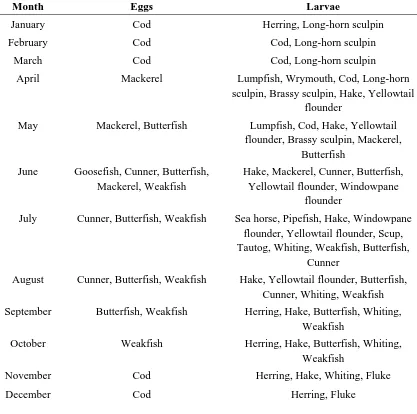
Table 2.5. Seasonality of fish eggs and larvae in Block Island Sound ... 67
Table 2.6. MARMAP ichthyoplankton data collected since 1978 ... 68
Table 2.7. First approximation of species preferences for habitats in the Ocean SAMP area... 71
Table 2.8. Percent occurrence of species landed in trawls taken in Block Island Sound ... 81
Table 2.9. Percent biomass of species landed in trawls taken in Block Island Sound... 81
Table 2.10. The occurance of marine mammals and sea turtles in Continental Shelf waters ... 88
Table 2.11. Common songbirds utilizing Block Island. ... 101
Table 2.12. Avifauna of the Ocean SAMP area... 102
5-4-2011 Approved Ocean SAMP Chapter 2 Page 6 of 134
Section 200. Introduction
1. The term “ecology,” translated from its Greek origins, literally means “the study of home.” From this, ecology can be thought of as a description, based on information gleaned and gathered during various studies, of the place where something resides. Ecology incorporates study not just of living things—the biota—but also non-living elements—the abiotic resources—because they profoundly influence where and how the living organisms exist. Ecology attempts to understand and describe the interactions between various living organisms with each other, between living organisms and the non-living resources existing in the local environment, and between the various abiotic components of the ecosystem.
5-4-2011 Approved Ocean SAMP Chapter 2 Page 7 of 134
5-4-2011 Approved Ocean SAMP Chapter 2 Page 8 of 134
3. The Ocean SAMP region is a busy maritime entryway to Narragansett Bay, Long Island Sound, Buzzards Bay and the Cape Cod Canal. It could be anticipated that much would be known about the ecology, biology and ecological functioning of this important region. To date, mainly small-scale areas of the sea floor and water column have been intensively studied in Rhode Island Sound, Block Island Sound or the Offshore Ocean SAMP area (the region immediately south of Rhode Island Sound and Block Island Sound, roughly that area south of Block Island to the Continental Shelf Slope, is considered here to be the Offshore Ocean SAMP area, and will be referred to as such throughout this chapter). Therefore understanding of the overall ecology of this ecosystem is somewhat fragmented.
4. The Ocean SAMP area is an ecologically unique region—the Rhode Island Sound and Block Island Sound ecosystems are located at the boundary of two intermingling biogeographic provinces, the Acadian to the north (Cape Cod to the Gulf of Maine) and the Virginian to the south (Cape Cod to Cape Hatteras). Because of this, the Ocean SAMP area contains an interesting biodiversity that is a mix of northern, cold water species and more southern, warm water species.
5. Unfortunately, there is no baseline of information for the area that pre-dates human disturbances such as trawl fishing, so scientists have been and are investigating a changed ecosystem. New studies, however, are underway by a variety of researchers sponsored by various agencies and institutions. This chapter takes the patchwork of available information and attempts to stitch it together into a coherent fabric that describes the basic ecology of the overall Ocean SAMP area. The chapter should be updated from time to time to reflect the findings of new research.
6. The Ocean SAMP area includes Rhode Island Sound and the central and eastern portions of Block Island Sound, both of which are shallow, nearshore continental shelf waters lying between Martha’s Vineyard/Elizabeth Islands, and Long Island. The area is dynamically connected to Narragansett Bay, Buzzards Bay, Long Island Sound, and the Atlantic Ocean via the Continental Shelf. Long Island Sound is a significant influence on the physical oceanography of the area due to the input of low salinity water from several major rivers (e.g., Connecticut River). A shallow sill extends from Montauk Point to Block Island at a depth of 15–25 meters, and partially isolates Block Island Sound from the Continental Shelf acting to some degree as a buffer to wave impacts. A canyon— Block Channel—extends several tens of kilometers from the deepest point of the sill, forming a deep connection between Block Island Sound and the Offshore Ocean SAMP area region of the Atlantic Ocean. The area of Rhode Island Sound and Block Island Sound overlapping the Ocean SAMP area is approximately 3,800 km2.
5-4-2011 Approved Ocean SAMP Chapter 2 Page 9 of 134
down stratification. Water column stratification, a naturally occurring event in Ocean SAMP area waters, reduces interaction between surface waters and the rest of the water column. Stratification often sets up physical conditions that concentrates food items and draws in marine life, becoming a “hot spot” of biological activity. In warm, shallow areas, stratification can sometimes lead to reduced oxygen concentrations in bottom waters, creating stressful conditions. Anoxia or hypoxia (no or little dissolved oxygen) are not reported for waters in the Ocean SAMP area.
8. With a direct, open connection to the Atlantic Ocean, salinity in the Ocean SAMP area has varying, small ranges, with lowest values in spring and summer as influenced by spring rains and melting snow pack. While these ranges are small, they can be important in driving circulation, assisting in the development and stability of stratification, and influencing the marine life inhabiting the region. The dynamic physical oceanography of the area sets up zones where sharp differences in temperature and/or salinity between inshore and shelf water create discontinuities, called fronts. These fronts, which occur mainly during summer along the Offshore Ocean SAMP area, and in a region just south of Block Island, provide unique biological and/or physical characteristics that cause them to be major fish attraction areas.
9. The Ocean SAMP area is a biologically productive area, comparable to though slightly less so than nearby waters, such as Long Island Sound and Nantucket Sound. The growth of phytoplankton is seasonal, with spring and fall generally being the most productive times of year. Species composition of phytoplankton in the Ocean SAMP area reflects its interactions with Narragansett Bay, Long Island Sound and the Continental Shelf regions. Like Narragansett Bay, the annual winter–spring bloom of phytoplankton in Rhode Island Sound appears to be becoming less consistent in its regularity. Zooplankton populations are also seasonal, generally following the trends of phytoplankton abundance. Species composition and seasonality of zooplankton abundances does not appear to have changed much over the past 50 or so years for dominant species. Shifts towards smaller species of copepods in Continental Shelf waters has been documented, but it is not clear if this trend is being mimicked in Ocean SAMP waters.
5-4-2011 Approved Ocean SAMP Chapter 2 Page 10 of 134
11.The organisms living in the sediments make up an important food source for demersal fishes, and play a critical role in the cycling of organic material. The benthic communities in the Ocean SAMP area are dominated by various species of amphipods, with tube dwelling species (e.g., ampeliscids) being the most dominant throughout the area. Bivalves, marine worms, and small shrimps make up the bulk of the remaining dominant benthic species. There appears to be correlation between the types of sediments making up the bottom and the species that occur in them, but there is not enough information at hand to map this in any meaningful way, or to make species–bottom type correlations with any degree of surety.
12.Marine mammals—whales, dolphins, porpoise and seals—utilize the Ocean SAMP area, but sparsely and generally on a seasonal basis. While whales will often venture into Ocean SAMP waters, they are not resident and generally are passing through; most whale sightings occur in deeper waters out over the Continental Shelf. Harbor seals do utilize Ocean SAMP waters during winter months, and a growing North Atlantic population of this species makes them a regular sight from late fall to early spring before the seals move north to breed. Gray seals are less common to the area, though increasing populations of this species is resulting in increased visitation as well. Sea turtles too are often sighted in Ocean SAMP waters, but most are traveling through the area and as such are considered occasional visitors.
13.Bird life throughout the Ocean SAMP area is varied, with waterbirds being the most abundant. Passerines utilize Ocean SAMP air space during migration periods, and Block Island is an important stop over and resting spot for many species. Use of Ocean SAMP waters by waterbirds is heaviest during winter months, with a peak from early March through mid-April. Water of less than 20 m in depth is important feeding habitat for diving ducks, and nearshore shallow waters are important feeding habitat for terns nesting onshore during summer months.
14.A major issue of concern for the overall ecology of the Ocean SAMP area is changing climate. Changes to fish communities are evident, and findings from adjacent waters suggest changes in phytoplankton and zooplankton communities as well; the benthos has not been studied robustly enough to determine if major shifts might be occurring, and is an area ripe for further study. Existing data however, suggest relative stability of the Ocean SAMP zooplankton community over the past several decades, which does not agree with trends reported for the larger North Atlantic area. Altered ecosystem conditions are allowing for various native species to increase in abundance, sometimes to nuisance proportions, and non-native (invasive) species are gaining a toe-hold as they expand their ranges, often out competing and excluding native species in the process. While less is known about marine microbial communities and disease organisms in Ocean SAMP waters, lobster shell disease is prevalent in the area and is being tied to changing climatic conditions. The northerly spread of shellfish diseases such as Dermo and MSX are also being documented, and again appear to be related to warming waters throughout the area.
5-4-2011 Approved Ocean SAMP Chapter 2 Page 11 of 134
5-4-2011 Approved Ocean SAMP Chapter 2 Page 12 of 134
Section 210. Geological Oceanography
1. The basic geological characteristics of the Ocean SAMP area create the foundation for its ecology. Large scale features, such as glacial moraines and boulder fields, are largely stable over long spans of time. Smaller scale features however, influence the physical forces of waves, tides and currents that move and sort the sediments which form the basic benthic habitat types available for colonization by organisms. Some of these habitats are fairly stable (e.g., boulders) while others are quite transitory (e.g., sand waves). Each habitat type supports different communities of organisms that make up the mosaic of benthic life in the Ocean SAMP area.
2. The geology of a region determines the basic characteristics upon which physical, chemical and biological elements of the ecosystem build. The geology is generally a static or slowly changing element of the landscape, though cataclysmic alteration (e.g., an earthquake or volcanic eruption) can occur and bring rapid, dramatic change. Block Island Sound, Rhode Island Sound, and the Offshore Ocean SAMP area, derive their basic topography and geology from Pleistocene glaciation activity, in particular the Wisconsinan Laurentide ice sheet that reached its maximum extent about 24,000 years ago (Stone and Borns 1986; Boothroyd and Sirkin 2002). The maximum southern extent of the ice sheet falls within the Ocean SAMP area, and its retreat created a unique patchwork landscape of boulders, sand, gravel, and moraine features that make up the ecological foundation of Rhode Island Sound, Block Island Sound and the Offshore Ocean SAMP area region.
5-4-2011 Approved Ocean SAMP Chapter 2 Page 13 of 134
Figure 2.2. Schematic of approximate location of major glacial lakes and direction of drainage flows approximately 19,000 years ago, and
5-4-2011 Approved Ocean SAMP Chapter 2 Page 14 of 134
5-4-2011 Approved Ocean SAMP Chapter 2 Page 15 of 134
Figure 2.3. Location of glacial moraines in the Ocean SAMP area. The map is a composite of the moraines as defined by several
5-4-2011 Approved Ocean SAMP Chapter 2 Page 16 of 134
5. The glacially derived bottom topography and composition determines the benthic characteristics that will create the ecological habitats of Rhode Island and Block Island Sounds. Boothroyd (2009) finds that the seafloor bottom in the Ocean SAMP area is characterized by four (4) major depositional environments, presented below in order of increasing grain size:
a. A shore-parallel feature, called a depositional platform sand sheet, comprised of medium sand containing small ripples. This feature serves an important function as a short-term sand storage area for supplying alongshore transport of sand to the east, or onshore transport to shoreline environments. These features provide habitats that regularly undergo significant change;
b. Features that are slightly lower than the cobble–gravel surrounding them, called cross-shore swaths, are composed of medium to coarse sand with small dunes. These features serve as a conduit for sand transport during storm events (Griscom 1978; Hequette and Hill 1993), providing habitat that undergoes regular, but less frequent, alteration;
c. Cobble gravel that is in equilibrium (e.g., no loss or accretion), but often rearranged after and during storm events, called depositional gravel pavement. These features provide habitat that is relatively stable, yet subject to occasional disturbance;
d. Concentrations of boulders and gravel inherited from the moraine, referred to as glacial outcrops, and which are more or less fixed in place, providing long-term habitats.
These features, containing sand, coarse sand, cobble–gravel, and boulders, describe the composition of the major benthic environments found in the Ocean SAMP area. These features are characteristic, though not definitive, of the seafloor composition which shows gradation from and between one to another of these features.
5-4-2011 Approved Ocean SAMP Chapter 2 Page 17 of 134
5-4-2011 Approved Ocean SAMP Chapter 2 Page 18 of 134
Figure 2.4. Bottom characteristics in a section of Rhode Island Sound as interpreted from
5-4-2011 Approved Ocean SAMP Chapter 2 Page 19 of 134
7. In recent side scan sonar surveys of portions of Rhode Island Sound (Figure 2.4), McMullen et al. (2008) found a mosaic of sedimentary environments that are the result of erosion and sediment transport, deposition and sorting, and reworking, with large areas comprised of transitory coarse-grained materials. Boulders were found scattered throughout the study area, though there were areas where concentrations of boulders existed, and which create areas of increased habitat complexity which would promote higher species diversity. Depositional areas where sediments were sorted and reworked tended to be found along channels and bathymetric high points. A preponderance of commercial fish trawl marks in depositional areas suggests an abundance of commercially important demersal fish species in these habitat/environment types. This in turn suggests a highly productive benthic community which is providing a rich food source. McMullen et al. (2008) found sand waves to be a predominant feature, and infer they are a result of coarse-grained bedload transport as was noted previously in this section. These features highlight the glacial origins of the area, and the stability of various features, for example glacial till, but also the transitory nature of other features, such as sand waves. Both bottom types—transitory and stable—are important characteristics in defining benthic habitat, and the types of organisms that will thrive there.