i
Open Geospatial Consortium
Submission Date: 2013-09-05
Approval Date: 2013-09-25
Publication Date: 2013-11-06
External identifier of this OGC® document: http://www.opengis.net/doc/DP/GEOXACML/GML3-Extension
Internal reference number of this OGC® document: OGC 13-101 Category: OGC®Publicly Available Discussion Paper
Editor: Andreas Matheus
OGC Geospatial eXensible Access Control Markup
Language (GeoXACML) 3.0 GML 3.2.1 Encoding
Extension
Copyright © 2013Open Geospatial Consortium
To obtain additional rights of use, visit http://www.opengeospatial.org/legal/.
Warning
Document type: OGC® Discussion Paper Document stage: Draft OGC Standard Document language: English
Attention
This document is written using the OGC template for Implementation Standards and contains normative language.
OGC 13-101
ii
This document is not an OGC Standard. This document is an OGC Discussion Paper and is therefore not an official position of the OGC membership. It is distributed for review and comment. It is subject to change without notice and may not be referred to as an OGC Standard. Further, an OGC Discussion Paper should not be referenced as required or mandatory technology in procurements
LicenseAgreement
Permission is hereby granted by the Open Geospatial Consortium, ("Licensor"), free of charge and subject to the terms set forth below, to any person obtaining a copy of this Intellectual Property and any associated documentation, to deal in the Intellectual Property without restriction (except as set forth below), including without limitation the rights to implement, use, copy, modify, merge, publish, distribute, and/or sublicense copies of the Intellectual Property, and to permit persons to whom the Intellectual Property is furnished to do so, provided that all copyright notices on the intellectual property are retained intact and that each person to whom the Intellectual Property is furnished agrees to the terms of this Agreement.
If you modify the Intellectual Property, all copies of the modified Intellectual Property must include, in addition to the above copyright notice, a notice that the Intellectual Property includes modifications that have not been approved or adopted by LICENSOR.
THIS LICENSE IS A COPYRIGHT LICENSE ONLY, AND DOES NOT CONVEY ANY RIGHTS UNDER ANY PATENTS THAT MAY BE IN FORCE ANYWHERE IN THE WORLD.
THE INTELLECTUAL PROPERTY IS PROVIDED "AS IS", WITHOUT WARRANTY OF ANY KIND, EXPRESS OR IMPLIED, INCLUDING BUT NOT LIMITED TO THE WARRANTIES OF MERCHANTABILITY, FITNESS FOR A PARTICULAR PURPOSE, AND NONINFRINGEMENT OF THIRD PARTY RIGHTS. THE COPYRIGHT HOLDER OR HOLDERS INCLUDED IN THIS NOTICE DO NOT WARRANT THAT THE FUNCTIONS CONTAINED IN THE INTELLECTUAL PROPERTY WILL MEET YOUR REQUIREMENTS OR THAT THE OPERATION OF THE INTELLECTUAL PROPERTY WILL BE
UNINTERRUPTED OR ERROR FREE. ANY USE OF THE INTELLECTUAL PROPERTY SHALL BE MADE ENTIRELY AT THE USER’S OWN RISK. IN NO EVENT SHALL THE COPYRIGHT HOLDER OR ANY CONTRIBUTOR OF
OGC 13-101
iii
Contents
1. Scope ... 6
2. Conformance ... 6
2.1 Overview ... 6
2.2 Specification identifier ... 6
2.3 Conformance classes related to implementation ... 6
2.4 Backward Compatibility with GML Extension to GeoXACML 1.0 ... 7
3. References ... 8
4. Terms and Definitions ... 8
5. Conventions ... 9
5.1 Abbreviated terms ... 9
5.2 Document presentation of the specification ... 9
6. GML encoded geometries within GeoXACML 3.0 (informative) ... 10
6.1 Introduction to GML encoded geometries ... 10
6.2 Introduction to GML nil geometries in the context of GeoXACML ... 10
6.3 Introduction to including complex data types into GeoXACML 3.0 ... 13
6.4 Introduction to XML encoded resources in GeoXACML 3.0 ... 14
7. GML 3.2 Simple Features Profile Encoding Extension (normative) ... 19
7.1 Introduction (informative) ... 19
OGC 13-101
iv
i.
Abstract
This standard defines the version 3.0 of a valid GML 3.2.1 geometry encoding as defined in Geography Markup Language (GML) simple features profile (with Corrigendum)to be used with the GeoXACML 3.0 Core standard.
The use of this encoding extension to GeoXACML 3.0 Core enables the direct use of GML 3.2.1 encoded geometries into a GeoXACML 3.0 Policy, an Authorization Decision Request or in an Authorization Decision’s Obligation element. It thereby improves the performance of deriving access control decisions, where geometries are involved as existing GML 3.2.1 geometry encodings must not be transformed to Well Known Text (WKT) as supported by GeoXACML 3.0 Core. Furthermore, the use of this encoding extension simplifies the implementation of a Policy Enforcement Point as it must not provide the transformation functions from GML to WKT and vice versa.
This encoding extension has its normative base in Geography Markup Language (GML) simple features profile (with Corrigendum).
ii.
Keywords
The following are keywords to be used by search engines and document catalogues.
ogcdoc, OGC document, GeoXACML, XACML, GML, access control, encoding extension
iii.
Preface
This document defines the version 3.0 of the GML 3.2.1 geometry encoding extension to GeoXACML 3.0 Core . It hereby supersedes the previous version GeoXACML 1.0 encoding extension for GML. It is important to notice that version 2.0 of GeoXACML does not exist and therefore no encoding extension of version 2.0!
Attention is drawn to the possibility that some of the elements of this document may be the subject of patent rights. The Open Geospatial Consortium shall not be held
responsible for identifying any or all such patent rights.
OGC 13-101
v
iv.
Submitting organizations
The following organizations submitted this Document to the Open Geospatial Consortium (OGC):
University of the Bundeswehr
Oracle
Defense Information Systems Agency (DISA)
National Geospatial-Intelligence Agency (NGA)
v.
Submitters
All questions regarding this submission should be directed to the editor:
Name Affiliation
6
1.
Scope
This Standard defines Geospatial eXensible Access Control Markup Language (GeoXACML) 3.0 GML 3.2.1 Encoding Extension as an encoding extension to
GeoXACML 3.0 Core which allows the processing of GML 3.2.1 encoded geometries. The supported geometry encodings for GML 3.2.1 is defined in Geography Markup Language (GML) simple features profile (with Corrigendum).
In particular, the use of this extension supports the direct use of GML 3.2.1 encoded geometries as part of the GeoXACML 3.0 Policy, an Authorization Decision Request or in an Authorization Decision’s Obligation element.
2.
Conformance
2.1 Overview
This Standard defines one standardization target type:
- implementation: GML 3.2.1 based geometry encoding that must be understood by a Policy Administration Point (policy creation and maintenance), a Policy Enforcement Point (processing of authorization decision requests and authorization decisions) and a geospatially enriched Policy Decision Point (GeoPDP) implementation (processing of GeoXACML policies and requests and producing an authorization decision).
NOTE: GeoXACML 3.0 is XACML 3.0 schema compliant. Therefore, a GeoXACML 3.0 Policy, or a ADR or AD instance is using the XACML 3.0 namespace. However, the GML encoded geometry instance will use the GML namespace.
2.2 Specification identifier
All requirements-classes and conformance-classes described in this document are owned by the specification identified as
http://www.opengis.net/spec/GEOXACML/3.0/GML3-Extension
2.3 Conformance classes related to implementation
OGC 13-101
7 Table 2 — Conformance classes related GeoXACML implementation
Conformance class Description Clause
SF-0 Support the use of GML geometry encoding based on GML 3.2 Simple Features Profile compliant with SF-0
SF-1 Support the use of GML geometry encoding based on GML 3.2 Simple Features Profile compliant with SF-1
SF-2 Support the use of GML geometry encoding based on GML 3.2 Simple Features Profile compliant with SF-2
2.4 Backward Compatibility with GML Extension to GeoXACML 1.0
This version of a GML Encoding Extension to GeoXACML 3.0 is normatively based on Geography Markup Language (GML) simple features profile (with Corrigendum). Because this normative base introduces constraints on GML 3.2.1 in terms of supported geometry encodings, not all geometry encodings supported by GML 3 may be used. In that sense, the backwards compatibility of a GeoXACML 1.0 policy using GML encoded geometries is limited. The backwards compatibility is broken if the used GML 3
OGC 13-101
8
Copyright © 2013 Open Geospatial Consortium
3.
References
The following normative documents contain provisions that, through reference in this text, constitute provisions of this document. For dated references, subsequent
amendments to, or revisions of, any of these publications do not apply. For undated references, the latest edition of the normative document referred to applies.
The following referenced documents are indispensable for the application of this document. For dated references, only the edition cited applies. For undated references, the latest edition of the referenced document (including any amendments) applies.
OASIS eXtensible Access Control Markup Language (XACML) Version 3.0, 22 January 2013, http://docs.oasis-open.org/xacml/3.0/xacml-3.0-core-spec-os-en.pdf
OASIS eXtensible Access Control Markup Language (XACML) Version 3.0 XML Schema, http://docs.oasis-open.org/xacml/3.0/xacml-core-v3-schema-wd-17.xsd
Geography Markup Language (GML) simple features profile (with Corrigendum), OGC Document 10-100r3
Geospatial eXtensible Access Control Markup Language (GeoXACML) 3.0 Core, OGC Document TBD
OGC Naming Authority (OGC-NA) Policies & Procedures OGC Document 09-046r2 http://www.opengis.net/doc/POL/OGC-NA/1.1
Policy Directives for Writing and Publishing OGC Standards: TC Decisions. OGC Document 06-135r7. http://www.opengis.net/doc/POL/STD
The Specification Model — A Standard for Modular specifications OGC Document 08-131r3. http://www.opengis.net/doc/POL/SPEC
4.
Terms and Definitions
This document uses the terms defined in Sub-clause 5.3 of [OGC 06-121r8], which is based on the ISO/IEC Directives, Part 2, Rules for the structure and drafting of
International Standards. In particular, the word “shall” (not “must”) is the verb form used to indicate a requirement to be strictly followed to conform to this standard.
For the purposes of this document, the following additional terms and definitions apply.
4.1 GML
OGC 13-101
9
Copyright © 2013 Open Geospatial Consortium
4.2 WKT
Well Known Text
5.
Conventions
5.1 Abbreviated terms
GeoXACML Geospatial eXtensible Access Control Markup Language
GML Geography Markup Language
ISO International Organization for Standardization
OASIS Organization for the Advancement of Structured Information Standards
OGC Open Geospatial Consortium
PAP Policy Administration Point
PDP Policy Decision Point
PEP Policy Enforcement Point
PIP Policy Information Point
UML Unified Modeling Language
SF Simple Features
WKT Well Known Text
XACML eXtensible Access Control Markup Language
XML Extensible Markup Language
5.2 Document presentation of the specification
This document presents the GML based geometry encoding based on GML 3.2.1 Simple Features Profile to be used with GeoXACML 3.0 Core specification using a
representation that follows the structures defined in the OGC Policy [The Specification Model — A Standard for Modular specifications OGC Document 08-131r3.
http://www.opengis.net/doc/POL/SPEC]. All normative material is organized as
OGC 13-101
10
Copyright © 2013 Open Geospatial Consortium
6.
GML encoded geometries within GeoXACML 3.0 (informative)
6.1 Introduction to GML encoded geometries
The Geography Markup Language (GML) enables a standards based approach for encoding geometry information using XML. The following example illustrates a GML 3.2 encoding of a geometry instance of type Circle.
<gml:CircleByCenterPoint numArc="1" xmlns:gml="http://www.opengis.net/gml/3.2"> <gml:pos srsName="urn:ogc:def:crs:EPSG::4979"
>29.963745015416 -90.029951432619</gml:pos> <gml:radius uom="m">1250</gml:radius>
</gml:CircleByCenterPoint>
Figure 1 — GML 3.2 geometry encoding example of CircleByCenterPoint
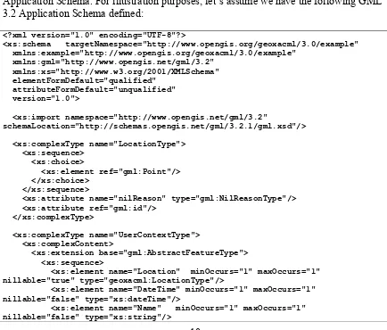
6.2 Introduction to GML nil geometries in the context of GeoXACML In GML 3.2, nillable geometries are a concept that must be manifested in a GML
Application Schema. For illustration purposes, let’s assume we have the following GML 3.2 Application Schema defined:
<?xml version="1.0" encoding="UTF-8"?>
<xs:schema targetNamespace="http://www.opengis.org/geoxacml/3.0/example" xmlns:example="http://www.opengis.org/geoxacml/3.0/example"
xmlns:gml="http://www.opengis.net/gml/3.2" xmlns:xs="http://www.w3.org/2001/XMLSchema" elementFormDefault="qualified"
attributeFormDefault="unqualified" version="1.0">
<xs:import namespace="http://www.opengis.net/gml/3.2"
schemaLocation="http://schemas.opengis.net/gml/3.2.1/gml.xsd"/>
<xs:complexType name="LocationType"> <xs:sequence>
<xs:choice>
<xs:element ref="gml:Point"/> </xs:choice>
</xs:sequence>
<xs:attribute name="nilReason" type="gml:NilReasonType"/> <xs:attribute ref="gml:id"/>
</xs:complexType>
<xs:complexType name="UserContextType"> <xs:complexContent>
<xs:extension base="gml:AbstractFeatureType"> <xs:sequence>
<xs:element name="Location" minOccurs="1" maxOccurs="1" nillable="true" type="geoxacml:LocationType"/>
<xs:element name="DateTime" minOccurs="1" maxOccurs="1" nillable="false" type="xs:dateTime"/>
OGC 13-101
11
Copyright © 2013 Open Geospatial Consortium <xs:element name="Role" minOccurs="0" nillable="true"
type="xs:string"/> </xs:sequence> </xs:extension> </xs:complexContent> </xs:complexType>
<xs:element name='UserContext' type='geoxacml:UserContextType' />
</xs:schema>
Figure 2 — Example GML 3.2 Application Schema
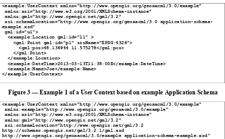
In the Application Schema above, it is possible to nil the <Location> element which includes a GML <Point> element. In the following, we can instanciate two different user contexts, one where a location is provided and another where the location information is withheld.
<example:Location gml:id="l1" >
<gml:Point gml:id="p1" srsName="EPSG:4326"> <gml:pos>48.136944 11.575278</gml:pos> </gml:Point>
</example:Location>
<example:DateTime>2013-03-13T11:38:00Z</example:DateTime> <example:Name>Joe</example:Name>
</example:UserContext>
Figure 3 — Example 1 of a User Context based on example Application Schema
<example:UserContext xmlns="http://www.opengis.org/geoxacml/3.0/example"
<example:Location gml:id="l2" xsi:nil="true" nilReason="withheld"/> <example:DateTime>2013-03-13T11:38:00Z </example:DateTime>
<example:Name>Joe</example:Name> </example:UserContext>
Figure 4 — Example 2 of a User Context based on example Application Schema
OGC 13-101
12
Copyright © 2013 Open Geospatial Consortium http://www.w3.org/2001/XMLSchema#dateTime and the user name provided in
element <Name> can be mapped to an <AttributeValue> of data type
http://www.w3.org/2001/XMLSchema#string. The mapping of the <Location>
attribute to an <AttributeValue> of data type
urn:ogc:def:dataType:geoxacml:3.0:geometry is – of course - different as illustrated below.
<AttributeValue DataType="urn:ogc:def:dataType:geoxacml:3.0:geometry" xmlns:gml="http://www.opengis.net/gml/3.2">
<gml:Point gml:id="p1" srsName="EPSG:4326"> <gml:pos>48.136944 11.575278</gml:pos> </gml:Point>
Figure 5 — Example 1 mapped to GeoXACML using <AttributeValue>
<AttributeValue DataType="urn:ogc:def:dataType:geoxacml:3.0:geometry"
Figure 6 — Example 2 mapped to GeoXACML using <AttributeValue>
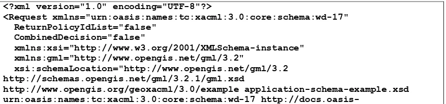
In cases, where the XML document from the GML Application Schema is inserted into an Authorization Decision Request into the <Content> element, it is not possible to use the IsNil or NilReason functions, as these functions operate on parameter data type Geometry only. But the nilled elements are not of type Geometry.
However, the use of Xpath expressions can be used to identify whether a XML element is nil and thereby not encoding a geometry as a child element.
<?xml version="1.0" encoding="UTF-8"?>
<Request xmlns="urn:oasis:names:tc:xacml:3.0:core:schema:wd-17" ReturnPolicyIdList="false"
CombinedDecision="false"
xmlns:xsi="http://www.w3.org/2001/XMLSchema-instance" xmlns:gml="http://www.opengis.net/gml/3.2"
xsi:schemaLocation="http://www.opengis.net/gml/3.2 http://schemas.opengis.net/gml/3.2.1/gml.xsd
http://docs.oasis-OGC 13-101
13
Copyright © 2013 Open Geospatial Consortium open.org/xacml/3.0/xacml-core-v3-schema-wd-17.xsd">
<Attributes Category="access-subject">
<Attribute AttributeId="Location" IncludeInResult="false">
<AttributeValue DataType="urn:ogc:def:dataType:geoxacml:3.0:geometry" gml:nil="true" gml:nilReason="withheld"/>
</Attribute>
<Attribute AttributeId="DateTime" IncludeInResult="false">
<AttributeValue DataType="http://www.w3.org/2001/XMLSchema#dateTime" >2013-03-01T11:38:00Z</AttributeValue>
</Attribute>
<Attribute AttributeId="Name" IncludeInResult="false">
<AttributeValue DataType="http://www.w3.org/2001/XMLSchema#string" >Joe</AttributeValue>
</Attribute> </Attributes>
<Attributes Category="access-ressource"> <Content>
<example:UserContext
xmlns:example="http://www.opengis.org/geoxacml/3.0/example" xmlns:xsi="http://www.w3.org/2001/XMLSchema-instance" xmlns:gml="http://www.opengis.net/gml/3.2"
xsi:schemaLocation="http://www.opengis.net/gml/3.2 http://schemas.opengis.net/gml/3.2.1/gml.xsd
http://www.opengis.org/geoxacml/3.0/example application-schema-example.xsd" gml:id="u1">
<example:Location gml:id="l2" xsi:nil="true" nilReason="withheld"/> <example:DateTime>2013-03-01T11:38:00Z</example:DateTime>
<example:Name>Joe</example:Name> </example:UserContext>
</Content> </Attributes> </Request>
Figure 7 — Example 2 mapped to GeoXACML ADR into <Content> element
For the example above, the following Xpath expressions inside a GeoXACML policy can be used to test wether the <Location> element is nilled and to obtain the nil reason:
boolean(/example:UserContext/example:Location/@xsi:nil='true')
string(/example:UserContext/example:Location/@nilReason)
6.3 Introduction to including complex data types into GeoXACML 3.0
The ability to include GML and hence XML encoded geometries into GeoXACML is defined in XACML 3.0 through the data type extension point and the “lax” processing of the <AttributeValue> content.
OGC 13-101
14
Copyright © 2013 Open Geospatial Consortium
Section 8.2 of the XACML specification states that “<xacml:AttributeValue> and
<xacml-context:AttributeValue> elements MAY contain an instance of a structured XML
data-type.”.
This capability allows the definition of the geometry data type, as defined by
GeoXACML 3.0 Core and to include a GML encoded geometry.
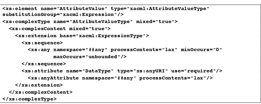
<xs:element name="AttributeValue" type="xacml:AttributeValueType" substitutionGroup="xacml:Expression"/>
<xs:complexType name="AttributeValueType" mixed="true"> <xs:complexContent mixed="true">
<xs:extension base="xacml:ExpressionType"> <xs:sequence>
<xs:any namespace="##any" processContents="lax" minOccurs="0" maxOccurs="unbounded"/>
</xs:sequence>
<xs:attribute name="DataType" type="xs:anyURI" use="required"/> <xs:anyAttribute namespace="##any" processContents="lax"/> </xs:extension>
</xs:complexContent> </xs:complexType>
Figure 8 — XACML schema definition of the <AttributeValue> element
The following example illustrates the use of the GML encoding for a
CirlceByCenterPoint with a XACML 3.0 <AttributeElement> and the GeoXACML 3.0 data type geometry.
<AttributeValue xmlns="urn:oasis:names:tc:xacml:3.0:core:schema:wd-17" DataType="urn:ogc:def:dataType:geoxacml:3.0:geometry"> <gml:CircleByCenterPoint numArc="1"
xmlns:gml="http://www.opengis.net/gml/3.2"> <gml:pos srsName="urn:ogc:def:crs:EPSG::4979" >29.963745015416 -90.029951432619</gml:pos> <gml:radius uom="m">1250</gml:radius> </gml:CircleByCenterPoint>
</AttributeValue>
Figure 9 — GeoXACML 3.0 geometry <AttributeValue> example with a GML3 encoded geometry instance
6.4 Introduction to XML encoded resources in GeoXACML 3.0
The typical use of this extension provides support for any GeoXACML request context that shall include geometries using GML 3.2 encoding. For example, a OGC Web Service HTTP/POST encoded request is encoded in XML. An in a case where geometries express parameters of the request (e.g. BBOX), the encoded geometry(ies) could directly be included into the request context.
OGC 13-101
15
Copyright © 2013 Open Geospatial Consortium
the request and the geometries are encoded in GML 3.2, it is possible to copy the OWS request 1:1 and insert it into the GeoXACML request context with no changes!
<Request xmlns="urn:oasis:names:tc:xacml:3.0:core:schema:wd-17" ReturnPolicyIdList="false"
CombinedDecision="false"
xmlns:xsi="http://www.w3.org/2001/XMLSchema-instance"
xsi:schemaLocation="urn:oasis:names:tc:xacml:3.0:core:schema:wd-17 http://docs.oasis-open.org/xacml/3.0/xacml-core-v3-schema-wd-17.xsd"> <Attributes Category="access-subject">
<Attribute AttributeId="subject:location:1" IncludeInResult="false"> <AttributeValue
DataType="urn:ogc:def:dataType:geoxacml:3.0:geometry">Point (29.963745015416 -90.029951432619)</AttributeValue>
</Attribute> </Attributes>
<Attributes Category="access-ressource"> <Content>
<GetFeature service="WFS" version="2.0.0"
xmlns="http://www.opengis.net/wfs/2.0" xmlns:myns="http://www.someserver.com/myns" xmlns:fes="http://www.opengis.net/fes/2.0" xmlns:gml="http://www.opengis.net/gml/3.2"
xmlns:xsi="http://www.w3.org/2001/XMLSchema-instance" xsi:schemaLocation="http://www.opengis.net/wfs/2.0 http://schemas.opengis.net/wfs/2.0.0/wfs.xsd http://www.opengis.net/gml/3.2
http://schemas.opengis.net/gml/3.2.1/gml.xsd">
OGC 13-101
16
Copyright © 2013 Open Geospatial Consortium
Figure 10 — Example of a WFS POST request included into a GeoXACML 3.0 ADR
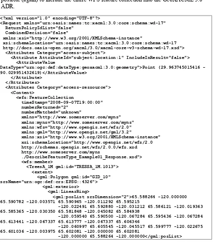
Another important use case for this extension is the ability to get access decisions for OWS responses, if encoded in XML and geometries encoded in GML 3.2. For example, a WFS response (the feature collection) is the resource for which a decision shall be
derived or upon which filtering shall be applied. With the use of this extension, it is possible (again) to include the entire WFS feature collection into the GeoXACML 3.0 ADR.
<?xml version="1.0" encoding="UTF-8"?>
<Request xmlns="urn:oasis:names:tc:xacml:3.0:core:schema:wd-17" ReturnPolicyIdList="false"
CombinedDecision="false"
xmlns:xsi="http://www.w3.org/2001/XMLSchema-instance"
xsi:schemaLocation="urn:oasis:names:tc:xacml:3.0:core:schema:wd-17 http://docs.oasis-open.org/xacml/3.0/xacml-core-v3-schema-wd-17.xsd"> <Attributes Category="access-subject">
<Attribute AttributeId="subject:location:1" IncludeInResult="false"> <AttributeValue
DataType="urn:ogc:def:dataType:geoxacml:3.0:geometry">Point (29.963745015416 -90.029951432619)</AttributeValue>
</Attribute> </Attributes>
<Attributes Category="access-ressource"> <Content>
<wfs:FeatureCollection
timeStamp="2008-09-07T19:00:00" numberReturned="2"
numberMatched="unknown"
xmlns="http://www.someserver.com/myns" xmlns:myns="http://www.someserver.com/myns" xmlns:wfs="http://www.opengis.net/wfs/2.0" xmlns:gml="http://www.opengis.net/gml/3.2"
xmlns:xsi="http://www.w3.org/2001/XMLSchema-instance" xsi:schemaLocation="http://www.opengis.net/wfs/2.0 http://schemas.opengis.net/wfs/2.0.0/wfs.xsd http://www.someserver.com/myns
./DescribeFeatureType_Example01_Response.xsd"> <wfs:member> 65.590782 -120.003571 65.590965 -120.011292 65.595215
-120.022491 65.592880 -120.031212 65.586121 -120.019363 65.585365 -120.030350 65.581848 -120.045082 65.584938
-120.059540 65.590500 -120.067284 65.595436 -120.067284 65.613441 -120.067337 65.613777 -120.067337 65.606346
-120.060997 65.605545 -120.045517 65.599777 -120.022675 65.601036 -120.003975 65.602081 -120.000000 65.602081
OGC 13-101
17
Copyright © 2013 Open Geospatial Consortium </gml:LinearRing> 59.488991 -52.198524 -59.485958 -52.169559
59.480400 52.152615 59.465576 52.141491 59.462002 -52.136417 -59.447968 -52.127190 -59.422928
52.120701 59.411915 52.117844 59.397972 52.116440
</wfs:FeatureCollection> </Content>
</Attributes> </Request>
Figure 11 — Example of a WFS Feature Collection included into the GeoXAML 3.0 ADR
The above examples leverage examples from the WFS 2.0 specification.
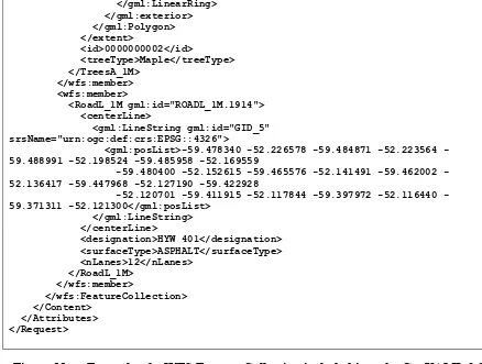
<?xml version="1.0"?>
OGC 13-101
18
Copyright © 2013 Open Geospatial Consortium </gml:Envelope>
Figure 12 — Example WFS POST request [Example 15, OGC 09-025r1 and ISO/DIS 19142 144 ]
<?xml version="1.0" ?> <wfs:FeatureCollection
<gml:Polygon gml:id="GID_10" srsName="urn:ogc:def:crs:EPSG::4326"> <gml:exterior>
<gml:LinearRing>
<gml:posList srsDimension="2">65.588264 120.000000 65.590782 120.003571 65.590965 120.011292 65.595215 120.022491 65.592880 120.031212 65.586121 120.019363 65.585365 120.030350 65.581848 120.045082 65.584938 120.059540 65.590500 120.067284 65.595436 120.067284 65.613441 120.067337 65.613777 120.067337 65.606346 120.060997 65.605545 120.045517 65.599777 120.022675 65.601036 120.003975 65.602081 120.000000 65.602081 -120.000000 65.588264 --120.000000</gml:posList>
</gml:LinearRing>
<gml:LineString gml:id="GID_5" srsName="urn:ogc:def:crs:EPSG::4326">
<gml:posList>-59.478340 -52.226578 -59.484871 -52.223564 -59.488991 -52.198524 -59.485958 52.169559 59.480400 52.152615 59.465576 52.141491 59.462002 52.136417 59.447968 52.127190 59.422928 52.120701 59.411915 52.117844 59.397972 52.116440 59.371311 -52.121300</gml:posList>
OGC 13-101
19
Copyright © 2013 Open Geospatial Consortium </centerLine>
<designation>HYW 401</designation> <surfaceType>ASPHALT</surfaceType> <nLanes>12</nLanes>
</RoadL_1M> </wfs:member>
</wfs:FeatureCollection>
Figure 13 — Example WFS response [Example 1, OGC 09-025r1 and ISO/DIS 19142 144 ]
7.
GML 3.2 Simple Features Profile Encoding Extension (normative)
7.1 Introduction (informative)
This encoding extension to GeoXACML 3.0 Core leverages the requirement “7.3.7 Requirement: Geometry encoding using XML” and provides one possible XML encoding to be used; hence GML 3.2.
In contrast to the WKT geometry encoding as introduced in the GeoXACML 3.0, GML 3.2 does not support the equivalent encoding to Empty. However, as GML defines the concept of nil, it is important for this encoding extension to define two functions to operate on nil goemetries: (i) IsNil(xs:Any):Boolean which enables a GeoXACML policy to test for nil and (ii) NilReason(xs:Any):String which supports to fetch the nil reason for further processing.
Req 1 Function IsNil
This function SHALL have the signature IsNil(Geometry):Booleanand the identifier as urn:ogc:def:function:geoxacml:3.0:geometry-is-nil.
This function shall return a TRUE value if the XML element, which according to a GML application schema includes a GML encoded geometry, is marked a nil=”true”.
This function shall return a FALSE value otherwise.
Req 2 Function NilReason
This function SHALL have the signature NilReason(Geometry):Stringand the identifier as urn:ogc:def:function:geoxacml:3.0:geometry-nil-reason.
OGC 13-101
20
OGC 13-101
21
Copyright © 2013 Open Geospatial Consortium
Annex A: Conformance Class Abstract Test Suite (Normative)
Conformance class: SF-0
Test that the implementation supports all valid geometry encodings in GML as listed in
Geography Markup Language (GML) simple features profile (with Corrigendum) for SF-0 in “Annex A Compliance testing“ according to Req 7 „ Geometry encoding using XML” defined by GeoXACML 3.0 Core.
Conformance class: SF-1
Test that the implementation supports Conformance Class SF-0.
Test that the implementation supports all valid geometry encodings in GML as listed in
Geography Markup Language (GML) simple features profile (with Corrigendum) for SF-1 in “Annex A Compliance testing“.
Test that the following functions are supported by the implementation:
Function URN Requirement
urn:ogc:def:function:geoxacml:3.0:geometry-is-nil
Req 1
urn:ogc:def:function:geoxacml:3.0:geometry-nil-reason
Req 2
Conformance class: SF-2
Test that the implementation supports Conformance Class SF-1.
Test that the implementation supports all valid geometry encodings in GML as listed in
OGC 13-101
22
OGC 13-101
23
Copyright © 2013 Open Geospatial Consortium
Annex C:
Bibliography
Annex D: Document revision history
Date Release Author Paragraph modified
Description
2013-03-20 0.1 Andreas Matheus
All Document created
2013-05-03 0.2 Andreas Matheus
All Comments received from Norman Brickman
![Figure 12 — Example WFS POST request [Example 15, OGC 09-025r1 and ISO/DIS 19142 144 ]](https://thumb-ap.123doks.com/thumbv2/123dok/3210347.1394023/18.612.89.523.219.700/figure-example-wfs-post-request-example-ogc-iso.webp)
