LOG HOUSES IN LES LAURENTIDES.
FROM ORAL TRADITION TO AN INTEGRATED DIGITAL DOCUMENTATION BASED ON THE RE-DISCOVERY OF THE TRADITIONAL CONSTRUCTIVE-GEOGRAPHICAL ‘REPERTOIRES’
THROUGH DIGITAL BIM DATA ARCHIVE
M. Espondaa, F. Pirainob, C. Stangac, D. Mezzinod
a
Associate Professor on the Azrieli School of Architecture, Carleton University, 1125 Colonel By Dr, Ottawa, ON K1S 5B6, Canada - [email protected]
b
Dept. ABC (Architecture, Built Environment and Construction Engineering), Via Bonardi 3, Milano, 20133, Italia - [email protected]
c
Politecnico di Milano, Graduate School in Architectural and Landscape Heritage – (chiara.stanga)@mail.polimi.it d
Carleton Immersive Media Studio (CIMS), 1125 Colonel by Drive, Ottawa, On, K1S 5B6 Canada, Interuniversity Department of Regional and Urban Studies and Planning (DIST), Politecnico di Torino, Via Sant’Ottavio, 20, 10122, Torino, Italy -
Commission II
KEY WORDS: Cultural Built Heritage, Vernacular Architecture, Log House, Intangible Cultural Heritage, Laser Scanning, HBIM, , Digital Workflows
ABSTRACT:
This paper presents an integrated approach between digital documentation workflows and historical research in order to document log houses, outstanding example of vernacular architecture in Quebec, focusing on their geometrical-dimensional as well as on the intangible elements associated with these historical structures.
The 18 log houses selected in the Laurentians represent the material culture of how settlers adapted to the harsh Quebec environment at the end of the nineteenth century.
The essay describes some results coming by professor Mariana Esponda in 2015 (Carleton University) and the digital documentation was carried out through the grant New Paradigm/New Tools for Architectural Heritage in Canada, supported by SSHRC Training Program) (May-August 2016).
The workflow of the research started with the digital documentation, accomplished with laser scanning techniques, followed by on-site observations, and archival researches. This led to the creation of an 'abacus', a first step into the development of a territorial-historical database of the log houses, potentially updatable by other researchers. Another important part of the documentation of these buildings has been the development of Historic Building Information Models fundamental to analyze the geometry of the logs and to understand how these constructions were built. The realization of HBIMs was a first step into the modeling of irregular shapes such as those of the logs – different Level of Detail were adopted in order to show how the models can be used for different purposes. In the future, they can potentially be used for the creation of a virtual tour app for the story telling of these buildings.
1. INTRODUCTION
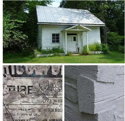
The log houses in the Laurentians are important not only because they represent the material culture of how settlers respected and responded to the harsh Quebec environment – living in harmony with it at the end of the nineteenth century, and with the birth of rustic cottages immersed in the wild landscape at the beginning of the twentieth century – but also because of the intangible elements attributed to them. For instance, in the Breards’ house (Figure 1) the insulation is made up of several layers of old newspapers – full of stories – that wrap the interior log walls; meanwhile the Cullens’ cabin – sadly abandoned – is still full of its own history, such as pictures, artifacts, clothes, books, and the palette of the first painter that introduced French Impressionism to Canada and mentored the Group of Seven (Mellen, 1970). At the onset of this research project, there were no specific studies regarding the history or construction techniques of these log houses. The challenge was to open a field of study that had not been deeply investigated: although these houses have been there for more than 100 years, researchers and the community do not “feel” them as being a part of their daily life. This paper is focused on the creation of a database of collected information to better understand the intrinsic relationship between wild landscape,
memory, and place that these log cabins have. The first step in the documentation process was to get in touch with the owners and ask them about their past and their building’s history, which
Figure 1. Breard Log House – Newspaper (1899) – Cornerwork (dovetail)
were often intertwined because the house has passed on from generation to generation.
This step was fundamental in gathering information, memories, and pictures. The digital survey was carried out using laser scanning which was essential to achieve geometrical-constructive data. Hand measurement was used to better understand connections and junctions.
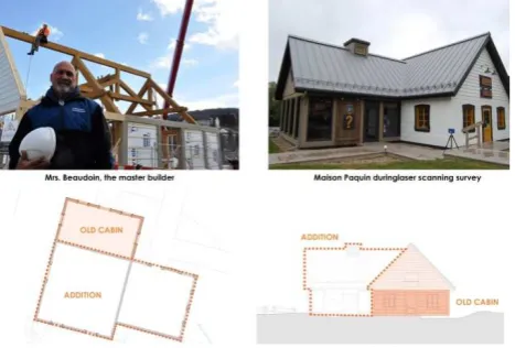
Later, 3D models helped to comprehend irregularities and geometry, as well as to communicate collected data using digital devices, such as phone apps, that can be a useful tool for guided tours of these log structures. The awareness of this type of vernacular architecture requires a mode of engagement from the community, which creates continuity with the past through the process of adaptation over time and use. A product of a grassroots effort in the log cabin preservation is the Maison Paquin (Figure 2). It was inaugurated as an Information Center in the village of Mont-Tremblant in July 2016. During the demolition of a commercial building in September 2011, a square log structure was discovered. This log cabin, like many others in the valley, was hidden behind clapboards. After several meetings between the city and the owner, they agreed to rebuild the log cabin which is now integrated into a new contemporary building facing a new public square. This is an excellent example of how a log house can be reused, while keeping its past history and re-creating new memories.
2. LOG HOUSES AND THEIR CONTEXT
Log houses are typical constructions from North America, characterized by courses of round or square logs interlocked at the corners by notching. In the villages of Mont-Tremblant (Figure 3) and Lac-Tremblant-Nord, the traditional log houses are not safeguarded by any regional or local registrations. To make that happen, it would be necessary for a different kind of engagement with the community that creates continuity from the past to present days, and even future, through a new adaptive process that is sensitive to current needs for a more inclusive, innovative and reflective society (Strategic Research Agenda, 2008). The potential for the universal enjoyment of architectural heritage in an inclusive society, together with the duty of improving the quality of its conservation, is a new element in the time of global knowledge.
This study explores not only the physical aspects of the log houses, such as the use of traditional building materials, craftsmanship and construction techniques, but also the socio-cultural values linked to living conditions, such as a sense of place and collective memory of the community (Esponda, 2016). As Mounir Bouchenaki demonstrated in the
“Communication Inaugurale” of ICOMOS 14th General Assembly and Scientific Symposium, “Even if tangible and intangible heritage are very different, they are two sides of the same coin: both carry meaning and the embedded memory of humanity” (Bouchenaki, 2012). Although they were built more than a century ago, these log houses still set an interesting example through their combined sustainable features i.e. in the use of local materials, roof’s slope, passive systems, and building performances. Preservation of these log cabins is fundamental not only for their technological aspects, but also as a result of the collective memory and its powerful connections with the environment that is expressed through the cabins’ material culture.
2.1 The Laurentides
The Laurentides are a mountain range in southern Quebec, Canada, north of Montreal and the St Lawrence River, running from the Mille Îles River to the north of Mont-Laurier and includes, from east to west, the territory between Terrebone and Argenteuil (Laurin, 1989). The region is one of the oldest mountain ranges in the world, shaped by the glaciers, full of rivers and lakes – close to ten thousand – and covered by dense forest. (Lesieur et al. 2004) The Montagnais First Nation tribe (the ancestors of the Algonquins and Iroquios) had a close relationship with the watercourse.
Forests have always played an important role in Canadian culture. Since the Algonquins, the white pine was an abundant resource used for a multitude of purposes: spiritual, cultural and medicinal. It provided habitat, transportation and food. The earliest log cabins of the eighteenth century in the Basses Laurentides were built with white pine with a diameter of 12 - 14 inches. White pine is softwood and easy to work; it does not split as easily as other types. With the extensive logging in the nineteenth and twentieth centuries, the white pine experienced a decline (Uprety et al., 2013). Most of the better quality logs with a large diameter were shipped to Europe. Consequently, most of the cabins in the Hautes Laurentides during the latter part of the nineteenth century were built by settlers with smaller diameter logs of white pine or spruce, between 6 to 10 inches.
3. CASE STUDY
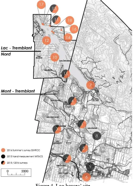
The 18 log houses analyzed for this paper are located in the two municipalities of Mont-Tremblant and Lac-Tremblant-Nord (Hautes Laurentides) and show different process of adaptation due to their peculiar environments (Figure 4). The first set of houses is located in the town of Mont-Tremblant and they are not as deeply immersed in their surroundings as the other group of houses in Lac-Tremblant-Nord. The latter are fully integrated
Figure 3. Lac Duhamel, Mont-Tremblant, Quebec (nineteenth- twentieth century)
with their environment and most of the time it is not possible to see them from the lake itself because they are concealed by trees and bushes. Boats are the only means of transportation to reach them in the summer and skidoos in the winter.
The 9 houses studied in Mont-Tremblant are: La Fleur (1), Thibault (2), Breard (3), Plourde (4), Refuge des Draveurs (5), Maison Paquin (6), Clagett (7), Curtis (8), Milk Cabin (9). The 9 houses located on the banks of Lac-Tremblant-Nord are: Holmes (10), Outhet (11), Arnott (12), Cullen (13), Madame Reeckie (14), Marina (15), Holgate (16), Ice box (17) and Gervais (18) inside the Natural Park.
The main goal of this essay is to create a digital data archive, using historical documents, while being aware of traditional construction techniques, doing surveys, oral interpretations, and processing the collected information through HBIM. The aim is to achieve a better understanding of how the remaining log cabins in Tremblant are the product of their history, the community and the values that kept changing with age. Hence, their preservation needs to be viewed as the process of adaptation (Esponda, 2016).
4. DIGITAL DATA ARCHIVE
Through the re-discovering of the traditional constructive-geographical repertoires – e.g. L'architecture à la française by Jean-Marie Pérouse de Montclos, 1982 – an important part of the research consisted of the creation of a digital data archive to combine all of the information on these log houses in a unique system to allow easy access potentially for future studies or conservation work. The detailed reconstruction and understanding of constructive richness and varieties, made of recurrent elements and specific features, allows sketching a mixed pattern of historical skills, workers and constructive
knowledge. The main criteria used to classify the data are: 1) general information, 2) building typology, 3) construction time and 4) type of intervention/maintenance. General information (Figure 5) concerns: orientation and the landscape’s relationship, original and current location (several have been dismantled and rebuilt over time from other villages), geometry, construction date, spatial layout, height and ceilings’ numbers, ornamentation/final coatings/colors and owners lives (past and current). Building typology (Figure 7) focused on: type of wood, diameter and shape of logs (square or round, placed in course horizontally or vertically), cornerwork (Figure 8), partitions, floors, roof style, size and windows orientation, and main materials. In this step was fundamental the reading of handbooks and manuals for the correct definition of the vocabulary of each component (Mackie, 1971; 1977). The digital data archive will become the basis for the creation of a repository of metadata that will be easily accessible by anyone and it will be necessary to integrate it with geographical references and system coordinate. Also, it will be possible to create updatable multilingual dictionaries (Fai et al., 2011; Brumana et al., 2013).
Construction time presented 5 chronological groups of houses: 1. Original settler houses in Mont Tremblant end of nineteenth century: (1867) Ferme Lafleur – Lac Ouimet, (1874) Thibault – Lac Duhamel, and (1898) Breard – Lac Gélinas (Figure 6). 2. Original houses which have been disassembled, moved and
Figure 6. Breard Log House - Exploded Axonometric View
Figure 5. General information chart
Figure 4. Log houses’ site
reassembled around 1960s and 2016 in Mont Tremblant: Plourde – Lac Mercier (built in 1850 as a post office in Saint-Andre Avelin and moved in 1980), Refuge des Draveurs (1850 and moved from Saint Eustache in 2007 to Le Maître Golf), Dr. Curtis (1880 and moved from La Conception in 1960 to Lac Ouimet), Clagett (1885 Saint Jovite, moved in 1962 as a guesthouse on the shores of Lac Tremblant and in 2003 was restored as a Québécois feature in the Hotel Quintessence) and Maison Paquin (1890 Saint Jovite, discovered in 2011 during demolition and rebuilt in 2016 as the visitor center in Saint Jovite).
3. In Lac Tremblant Nord Hunting lodges: Holmes (1890), Arnott (1908), Gervais (1950), and Painters Cabins: Outhet house (1912), Cullen house (1920) and Holgate (1923)
4. Other early houses in Lac Tremblant Nord (1920-1930): Madame Reekie (1921) and Marina (1925).
5. New log houses (2005-2015): Archambault II, an addition to Archambault I (2007) and Archambault III close to Lac Narcise (2010).
An univocal code was created for each house in order to facilitate their classification and their executionin the database.
5. WORKFLOW
The approach used in this study combines 3 main sources – survey campaign, oral tradition and historical documentation – and is based on data cross-check. Different aspects have to be taken into consideration in order to have a global understanding of the log houses, their history and their values: general info, survey and related processing data, main drawings, BIM, construction analysis, material decay, intangible element, building’s evolution, their restoration, and performance.
5.1 Survey
The survey includes two phases: the first, based on hand measurements, occurred in the summer of 2015 and the second, using laser scanning (Faro) in May-July 2016. Laser Scannig technology allowed to gain a more accurate data and details while reducing the invested time. Laser scanning survey proved to be an indispensable tool in order to record the complexity and the geometric irregularities (Brumana et al., 2014): these constructions were built by craftsmen and it is important to highlight the different techniques and materials. However, the direct observation is fundamental as it is always beneficial to better understand all the constructive details.
5.2 Laser scanner survey
The process took place in 3 separate sessions and it required 6-10 scans of each house, whose duration and number depended on their geometry, dimension, geographical position (bank or flat land) and other external factors such as amount of vegetation and weather conditions.
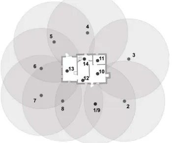
First of all, it was necessary to decide the most convenient position to place the scanner (Figure 9-10). The laser scanning survey (the laser is a fundamental tool for accurate 3D modeling: Oreni et al., 2012) is made up of 172 scans for all the 18 houses (roughly 8 billion points) registered by means of checkerboards and spherical targets. The targets required for laser scanning (checkerboard and spheres) were located all around the houses and on strategic points on their façades. The location of these targets is fundamental for matching the different point clouds: each scan requires a minimum of 3 visible targets in order to register correctly. The final
Figure 9. Thibault log cabin during the survey
Figure 10. Keyplan showing laser scanner's position during the survey of Thibault log cabin Figure 7. Type of log wall construction
registration precision was better than ±3 mm, i.e. equivalent to the precision of the used laser scanner (Faro Focus 3D). In case of data missing from the laser scanner, hand measurements were used and to mark the difference, they were reported in the drawings using a distinct line. The surveys in the two locations were performed taking into consideration the uniqueness of the environments. In particular, in Lac-Tremblant-Nord the main challenge was to carry the technical equipment to the right location, because the houses are reachable only by boat and the spots for the laser scanner had to be adjusted to the dense vegetation surrounding the buildings.
5.3 Processing data
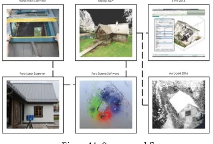
The .fls files (coming from the laser scanning) for each house had to be matched in order to obtain an overall picture of the building. Using Scene, the files were converted and exported to .pts in order for them to be imported in Recap. Scene was also used to create orthophotos, clipping the point cloud and placing the axes along the façade. In Recap it was then possible to polish the point clouds from elements that were superfluous (vegetation, roads, etc.) and save the files in .rcp (extension necessary to use them in Autodesk Environment). These newly created documents were then imported into AutoCad and Revit for further elaboration, like drawings and HBIMs (Figure 11).
Figure 11. Survey workflow
5.4 Drawings
The traditional drawings, such as floor plans, sections and elevations, were obtained using the point cloud in AutoCad. As mentioned previously, hand measurement was performed where data from the laser scan was missing, or to measure windows and frame details with a higher margin of error. In fact, comparing all the hand measurements and laser scanning drawings of the houses it is possible to show that the average error is about 8,7 cm due to the complexity and irregularity of the logs (Figure 12).
5.5 HBIM (Historical Building Information Modeling) A focus point of the paper is the generation of an accurate model of the log house. Nowadays, most 3D models of architectural building are based on procedures that are able to generate surfaces using a mesh-based algorithm, producing a pure model form (without information or integrated documentation). On the other hand, BIM technology requires a parametric representation of geometry and not simply a static shape (Barazzetti et al., 2015).
In this research, the idea was to find a procedure to create a BIM model (modeled in Revit) that preserved the metric accuracy captured by laser-scanner. In fact, the first element to consider is the set of dense laser scanning point clouds, which reveal the geometric complexity of the buildings.
For the generation of BIM model, the identification of the different architectural elements is required in order to correctly replicate the logic of construction (how the building was actually constructed) integrated with spatial relationships and attributes (Hichri et al., 2013). Also, this could allow potentially to create a web-BIM library of the different elements.
This 'HBIM abacus' enriched by the different construction elements and construction typologies is obtained integrating high detailed survey (as for log-walls and cornerworks) and historical documents. It can be updated by future investigations and implemented by further log-houses examples located in other regions, highlighting the uniqueness of the different geographic areas, together with the recurrent elements.
Furthermore, the principal goal during the generation of the BIM was to model the log house directly in Autodesk Revit. The work carried out in the software consisted of the digital modeling of parts that could be reasonably approximated with standard Revit families (like roof, ceiling, stairs, beam, railing, column, door, generic object, window, and so on).
On the other hand, the research tries to find a methodology to turn the laser scan of an irregular log into an advanced BIM element, realizing an ‘intelligent object’ with a dynamic shape, material information and other properties. The study presents 3 approaches, which were used to model the different families of the log house (Figure 13). Each level presents a specific level of accuracy, time (to model), parametric components, and detail. In this way, depending on the purpose and on the available time, it is possible to decide which one is the “best” approach. Furthermore, it is always possible to update the model from the previous level, to the next levels, or vice versa (Fai et al., 2014). Logs are one of the most complicated objects to model when a correct BIM representation is the final goal, especially in the case of laser-scanning point clouds that reveal geometric irregularities. The 3 Log Walls Level of Details and relative features are described below.
Figure 12. Refuge des Draveurs plan - comparison between
5.5.1 Log Walls Level of Detail 1: Log walls are created as generic wall family. First of all it was necessary to set up the position of the section and the thickness of the point cloud’s slice according to model scale. After that, the original wall’s track was traced with the ‘model line’ tool. This was the base for the modeled wall that was created using the ‘generic wall’ family along with the ‘pick line’ tool. The modeled wall is a parametric object that can be edited in its properties (e.g. accurate thickness, height, material). Other information can be added and altered (i.e. building’s construction date, log age, number of logs, type of log, type of corner work, and so on). Lastly, orthophotos can be attached to the modeled wall (Figure 14).
Figure 14. Log Walls Level of Detail 1
5.5.2 Log Walls Level of Detail 2: In this case each log is modeled with a simplified shape, following the main deflection. It was better to reduce the point cloud to a single log using the ‘section box’. First of all, it was necessary to set up a reference line that needed to be drawn at the base of the log (‘reference line’ tool). Then, the ‘work plane’ was oriented to the vertical plane inherent to the reference line.
So, it was possible to trace the length and deflection of the log, using the ‘spline’ tool. After that, using the ‘beam’ family, it was possible to create the log by tracing two main horizontal sections, joined together on the path created before. The two horizontal sections were approximated on a pure geometric shape (square, rectangular, circle) with parametric dimensions. In this case the modeled log is a parametric object with a simplified geometry (Figure 15).
Figure 15. Log Walls Level of Detail 2
5.5.3 Log Walls Level of Detail 3: The tool used to accurately model existing conditions of aged log is the ‘conceptual mass’ tool. The initial steps in the procedure are close to the LoD 2. In this case, it was better to reduce the point cloud to a single wall of logs using the ‘section box’.
First of all it was necessary to create a new ‘in-place mass’ and set up a reference line that needed to be drawn at the base of the wall (‘reference line’ tool). Then, the ‘work plane’ was oriented to the vertical plane inherent to the reference line. The length of
each log was traced using the ‘spline’ tool. At this point it was important to follow the deformation of each log.
Once all of the splines were drawn, they were divided using the ‘divide path’ tool in order to generate nodes where the section of each log was traced (in this case 30 cm). Each traced log section was joined together creating a solid, using ‘create solid’. In this case, the modeled logs are not parametric objects, but it is possible to add other proprieties, as for LoD 1. However, each section could become parametric using a pure geometric shape, but in turn lose accuracy and detail. The choice between these two procedures depends on the building itself and the purpose of the research. Level of Detail 3 is the most accurate representation of the logs, as it follows their irregularities and deflections, but it takes a considerable amount of time (Figure 16).
Figure 16. Log Walls Level of Detail 3
5.6 FROM HBIM TO BHIMM (Building Historical Information Modeling Management)
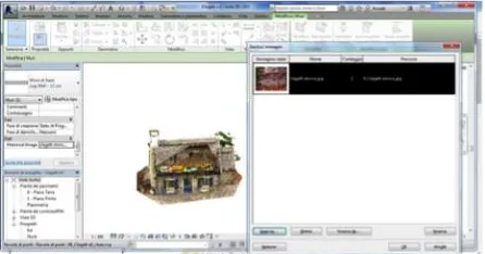
BIM system is a useful support to integrate the 3D model with the collected data. In BIM environments, like the Autodesk Revit software, information contained in the Digital Data Archive can be added to the different modeled objects: materials, preservation status, constructive techniques, documents, historical data, audio files – in this study most of the data comes from oral tradition. In fact, each element generated in Revit contains a ‘property window’ that displays several pieces of information, which can be updated or modified on a constant basis. Furthermore, thanks to the ‘shared parameters’ tool (Figure 17) it is possible to create a specific parameter and link an external file (doc, url, jpeg, and so on) to the model that becomes the Digital Data Archive itself. In doing so, it is possible to “translate”/add intangible elements into HBIM models: for instance, the meaning or reason of some architectural choices, the lifestyles of the original inhabitants, and/or the know-how of some specific techniques. In this way, the generated model becomes a very useful tool because it represents the starting point for future research. It can also be used for educational, referential and informational purposes, and as a basis for comparison in the study of similar buildings. The HBIM can be used for further analysis involving different
specialists (architects, engineers, historians, conservators, constructors, and so on) guaranteeing the interoperability (Barazzetti et al., 2015). This is the transition from HBIM to HBIMM, which is the complex management of the historical building heritage (Figure 18).
Figure 18. HBIM of Clagett log cabin
6. CONCLUSION
The study reveals the great variety within the log house typology located in the Laurentides.
These houses have several characteristics in common as settlers had to follow strict rules in order to build them; rules such as dimensions, local materials, pitched roof and the roof’s underside showcasing the typical curve – coyau, the use of the toupé between logs for insulation, and in the east and west façades symmetrical windows are implemented to allow cross ventilation. However, what makes each log house unique is their intangible elements. The red, yellow and blue colours of the windows and doorframes were used most frequently as an association with the symbols of the French Catholic culture in Quebec (Esponda, 2016). That is why it is important to have a thorough comprehension of the specific context – landscape, history and evolution of each construction and the sociocultural, symbolic and economic aspects of the people that have lived there. They are so intertwined that it is not possible to isolate them in the study. During the research, it was possible to map the log houses in Laurentides, creating a network of owners and log houses, so the opportunity arises to create a website/forum where the owners tell the history of their buildings, family and village. While doing so, conferences and events about this theme could be a way to pass down and involve people in this specific built heritage. Constructions, such as the log houses analyzed for this study, are a clear testimony of how the past history and tradition is connected to the present day’s culture and values, and it is reassuring to see most of them still in good condition. Only one specific log house, the Cullen house, exhibited a different situation. The house is abandoned and its condition is getting worse with each passing year, so it is possible that it will drastically change in a one-year time frame. Last summer part of the roof collapsed. In the long run, its survey and its 3D model could be used for future digitally assisted fabrications to rebuild the log house, maintain its tradition and values associated with the Group of Seven, and to study this typology (this is the only one, analyzed in this research, to have vertical boards). The maintenance of this type of construction should follow the principles underlined by the International Wood Committee (ICOMOS, 1999) that underlines the importance of preserving the historic timber
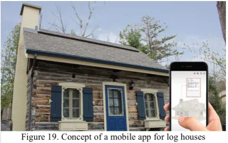
structures from all periods, and the conservation of the great diversity of construction and species of wood used to build them. This is due to both the increasing scarcity of this kind of construction and their cultural significance – authenticity and integrity, and their cultural values – that need to be regenerated over the years. To do so, these houses need to be maintained and renovated through adaptation projects. In this regard, it is important to know the ICOMOS principles for a correct restoration project, following the minimum intervention principle with the aim of improving the legibility of their historical integrity. Through the digitally archived data, which is an ‘historical catalogue’ of construction technologies, recurring trends can be analyzed and studied to better understand this type of construction. In the Built Heritage, the use of HBIMM technologies allows for interoperability among different fields, facilitating the exchange of digital information and its storage on web platforms, easily accessible both to experts and non-experts (Bianco et al., 2013). At the same time, with this digital documentation it will be easier to realize applications for smartphones and other devices, creating virtual guided tours to engage tourists. The goal is to use this technology to pass down even the intangible elements connected to these houses. A possible application is the creation of a tourist route through the 18 log houses, supported by a mobile app (Figure 19). The purpose is not to replace the actual visit to the buildings on site, but to stimulate and increase the interest of the stakeholders in the Built and Cultural Heritage. It helps grow a ‘participated awareness rising’ among people, local and tourists, which is a necessary element for the preservation and pass down tangible and intangible memories (vernacular constructive tradition, ancient worker skills, and their material culture).
This research is just a first step in the documentation of these log houses and, for this reason, further time and resources must be invested to map and study the other existing log houses in order to have a complete knowledge of this type of construction. The more people understand the tangible and intangible richness of this Built Heritage, the more it will increase in values.
ACKNOWLEDGMENTS
This research was supported by the Social Sciences and Humanities Research Council of Canada. Special thanks go to professors Stephen Fai (principal Investigator of the grant New Paradigm/New Tools -SSHRC-) Mario Santana Quintero and Luis Bello Caballero, CIMS Lab and CEE for providing the survey equipment and support during the laser scanner survey and the process of data. Special thanks to Louis Royer, Denis Archambault, Pascal De Bellefeuille, Jane and Burke Smith, Michel Tremblay, Rickson Outhet, Carole and Alain Plourde
and John Holmes, owners of 8 of the 18 log houses, for being so kind to open the doors of their homes and share their stories with us, and to let us carry out our surveys.
REFERENCES
Banfi F., 2016. Building Information Modelling – A Novel Parametric Modeling Approach Based on 3D Surveys of Historic Architecture. 6th International Conference, EuroMed 2016, Nicosia, Cyprus, October 31 – November 5, 2016, Proceedings, Part II. Digital Heritage. Progress in Cultural Heritage: Documentation, Preservation, and Protection, ISBN 978-3-319-48495-2, pp. 116-127
Barazzetti, L., Banfi, F., Brumana, R., Previtali, 2015. Creation of parametric BIM objects from point clouds using NURBS. In: The Photogrammetric Record 30 (152), pp. 339-362.
Bianco, I., Del Giudice, M., Zerbinatti, M., 2013. A database for the architectural heritage recovery between Italy and Switzerland. In: The International Archive of the Photogrammetry, Remote Sensing and Spatial Information Sciences, Strasbourg, France, Vol. XL-5/W2, 2013, pp. 103-108.
Bouchenaki, M., 2012. The interdependency ofthe tangible and
intangible Cultural Heritage, ICOMOS 14th General Assembly
and Scientific Symposium 14e Assemblée Générale et Symposium Scientifique de l’ICOMOS.
Brumana R., Orendi D., Cuca B., 2013. HBIM for conservation and management of Built Heritage: towards a library of vaults and wooden bean floors. In: ISPRS Annals of the Photogrammetry, Remote Sensing and Spatial Information Sciences, Volume II-5/W1, 2013, XXIV International CIPA Symposium, 2 – 6 September 2013, Strasbourg, France, pp. 215-221.
Brumana, R., Oreni, D., Cuca, B., Binda, L., Condoleo, P., Triggiani, M., 2014. Strategy for integrated surveying techniques finalized to interpretive models in a byzantine church, Mesopotam, Albania. In: International Journal of Architectural Heritage, 8 (6), pp. 886-924.
Esponda Cascajares, M., Crespo, I. J. G., 2015. Tecnología constructiva de las cabañas de madera, en las Laurentides (Quebec, Canadá). Primer Congreso Internacional Hispanoamericano de Historia de la Construcción, Segovia, España.Instituto Juan de Herrera. Vol I. pp. 573-583.
Esponda, M., 2016. Material culture: Square-log cabins in the Village of Mont-Tremblant, Quebec, In: Melcher, K., Stiefel, B. L.,Faurest, K., Community-Built: Art, Construction, Preservation, and Place, Routledge. Chapter 7.pp. 102-120.
Fai S., Graham K., Duckworth T., Wood N., Attar R., 2011. Building Information Modeling and Heritage Documentation. CIPA 2011 Conference proceedings, XXIIIrd International CIPA Symposium.
Fai S., Rafeiro J., 2014. Establishing an appropriate Level of Detail (LoD) for a building information model (bim) – West Block, Harliament hill, Ottawa, Canada. In:
ISPRS Annals of Photogrammetry, Remote Sensing and Spatial Information Sciences, Volume II-5, 2014,
pp.123-130.
Hichri, N., Stefani, C., De Luca, L. and Veron, P., 2013. Review of the “as-built BIM” approaches. In: International Archives of Photogrammetry, Remote Sensing and Spatial Information Sciences, 40(5/W1), pp. 107–112.
ICOMOS, International Wood Committee Charter, Principles For The Preservation Of Historic Timber Structures (1999), https://www.icomos.org/images/DOCUMENTS/Charters/wood _e.pdf
Laurin, S., 1989. Historie des Laurentides, Institute Québécois de recherché sur la culture, Quebec.
Lesieur, D., P. Lefort, Y. Bergeron and E. Lauzon., 2004. Reconstitution de l’historique des perturbations naturelles et de la composition de la forêt pré-industrielle au sud de Val d’Or. Rapport de la Chaire industrielle en aménagement forestier durable soumis à Domtar.
Mackie, A., 1971. Building with Logs, B. Allan & Ida Mary Mackie, Prince George
Mackie, A., 1977. Notches of all Kinds. A Book of Timber Joinery, Firefly Books, Willowdale.
Melen, P., 1970-1971. Maurice Cullen and the Group of Seven. Vie des Arts. No. 61. pp. 26-29.
Mezzino, D., & Rinaudo, F., 2015. GIS and 3D modeling for Cultural Heritage. In R. Tamborrino (Ed.), Telling the history of the city in the age of the ICT Revolution (pp. 143–153). Roma: Centro per lo studio di Roma (CROMA) - Università degli studi Roma Tre.
Mezzino, D., Pei C. W., Santana-Quintero M., 2016. Interpretation of Sensor-Based 3D Documentation. In Münster S., Pfarr-Harfst M., Kuroczyński P., Ioannides M. (Eds.), 3D Research Challenges in Cultural Heritage. Volume 2: How to manage data and knowledge related to interpretative digital 3D reconstruction of Cultural Heritage? Berlin: Springer.
Oreni, D., Brumana, R., Della Torre S., Banfi, F., Barazzetti, L., Previtali, M., 2014. Survey turned into HBIM: the restoration and the work involved concerning the basilica di Collemaggio after the earthquake (l’Aquila). In: ISPRS Annals of the Photogrammetry, Remote Sensing and Spatial Information Sciences, Vol. II-5, 2014, Riva del Garda, Italy, pp. 267-273.
Pérouse de Montclos J-M., L'architecture à la française: 16e, 17e, 18e siècles, Picard, Parigi, 1982.
Phleps, H., 1982. The craft of log building: a hand-book of craftsmanship in wood, Lee Valley, Ottawa.
Potvin, D., 2003. Mont-Tremblant Au Coeur des Laurentides, Outremont, QC:Trécarré.
Uprety, Y., Asselin, H., Bergeron, Y., 2013. Cultural importance of white pine (Pinus strobus L.) to the Kitcisakik Algonquin community of western Quebec, Canada. In: Canadian journal of Forest Research, vol. 43 n. 6, pp. 544-551.