THE VAST PROJECT: VALORISATION OF HISTORY AND LANDSCAPE FOR
PROMOTING THE MEMORY OF WWI
E. Nocerinoa*, F. M ennaa, D. M orabitoa, F. Remondinoa, I. Toschia, D. Abateb, D. Ebolesec, E. Farellad, F. Fiorilloe, S. M intof, P. Rodríguez-Gonzálvezg,h, C. Slongoi, M . G. Speraj
a 3D Optical M etrology (3DOM ) unit, Bruno Kessler Foundation (FBK), Trento, Italy <nocerino><menna><morabito><remondino>><toschi>@fbk.eu
b
The Cyprus Institute Science and Technology in Archaeology Research Center (STARC), Nicosia, Cyprus – [email protected] c
Dept. of Culture and Society, University of Palermo, Italy – [email protected] d Dept. of Architecture, Federico II University, Naples, Italy – [email protected]
e
Department of Civil Engineering, University of Salerno, Italy - [email protected] f
Sat Survey srl, Venezia M estre, Italy – [email protected]
g TIDOP Research Group, Higher Polytechnic School of Avila, University of Salamanca, Spain - [email protected] h Dept. of M ining Technology, Topography and Structures, University of León, Ponferrada, León, Spain - [email protected]
i
Ossicolor, Spormaggiore (TN), Italy – [email protected] j
M IRA snc (http://mira3d.it), Palermo, Italy - [email protected]
Commission II
KEY WORDS : 3D modelling, Surveying, WebGIS, Awareness-Raising, Education, First World War, War heritage
ABS TRACT:
The VAST (valorisation of history and landscape) project (http://vast.fbk.eu/) was part of the initiatives promoted by the Autonomous Province of Trento (Italy) for the commemoration of the 100th Anniversary of the First World War (WWI) outbreak. The project was primarily aimed to document and promote, through 3D digitization approaches and communication material, the memory of sites, theatre of the world conflict. The Italian Trento’s province had been under the Austro–Hungarian Empire until the end of the WWI, during which represented a crucial and bloody war front between the Aust rian and Italian territories. The region was constellated of military fortresses, trenches and tunnels, most of them now ruined and at risk to slowly disappear. 3D surveying and modelling techniques have been exploited to produce 3D digital models of structures and objects, along with virtual tours, communication material and a WebGIS of the area. All the products are available on the web for valorisation, educational and communication purposes.
a) b)
c) d)
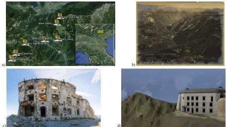
Figure 1. (a) Positions of the Austro-Hungarian forts along the old national border (before 1918) between Italy and the Austro–Hungarian empire - nowadays a regional border between T rentino – Alto Adige and Veneto (b) An historical picture showing the plateaus and highlands ‘Altipiani
Cimbri’. (c) Vezzena fort as it appears today and (d) its virtual reconstruction.
1. INTRODUCTION
VAST (valor izzazione stor ia e ter r itor io/valorisation of history and landscape) was an interdisciplinary project, run from June 2013 to June 2015 with the ambition of exploiting current 3D modelling and visualization technologies to reinforce and enrich with new significance the heritage sites and monuments on the mountainous area in the North East of Italy related to the Great War. 3D digital models, virtual tours and WebGIS were produced to document, communicate and valorise military fortresses, war objects and the entire landscape of the Altipiani Cimbr i, i.e. the plateaus and highlands of Luser na, Lavar one and Folgar ia (Trento province, Italy). The project was scientifically coordinated by FBK-3DOM and run in collaboration with various partners and local stakeholders, with complementary expertise in cultural and technical research field to reach the goals of digitizing and communicating the WWI heritage and memory for the commemoration of the 100th Anniversary of the war outbreak. Different researchers, now working for other institutions, took part in project activities. Compared to previous publications showing partial results of the VAST project, this paper aims at summarising all the relevant results achieved within the project and follow-up activities, emphasizing the social, cultural and educational values of the presented research.
1.1 Background and motivation
The area under investigation was part of the Austro–Hungarian Empire until the end of the First War World (WWI) and represented one of the crucial border with the Italian kingdom (Figure 1a). Consequently, the territory was constellated of military fortresses, trenches and underground tunnels (Section 1.2) that represent a unique heritage patrimony, especially for the Altipiani Cimbr i (Figure 1b), an area lived by an ethnic and linguistic minority, the Cimbrians, a population descending from German people and speaking Cimbrian, a dialect of Bavarian that has maintained characteristics of M iddle High German (Coluzzi, 2004). The Cimbrians are one of the minorities protected by Italian State Law since 1999 and nowadays they live in four different areas in the North-East region of Italy, one of them being the plateau of Lavar one, Folgar ia and Luser na. The VAST project was strongly supported by members of the Cimbrian community, persuaded that the new digital technologies would have helped in the valorisation and preservation of their cultural heritage.
M ost of the military constructions are now ruined (Figure 1c) and risk to slowly disappear. To reach the primary goal of enhancing the conscience of what the war had represented for the local community, in particular for the young generations that have not directly witnessed its cruelty, 3D military structures and objects were surveyed and modelled, producing new dissemination and communication materials, displayed both in museums and along the main routes running across the Altipiani Cimbr i territory. The realized products comprise both classic informative posters, mainly devoted for an adult audience, and virtual and interactive reconstructions of war buildings, objects and landscape, more appropriate for the young generations.
1.2 The Austro-Hungarian forts in Trentino
In the XIX century, the Trentino – Alto Adige was the last Italian territory still belonging to the Austro-Hungarian Empire.
Aiming at protecting it against the spread of the Italian unification movement, more than 50 military fortifications, or wer k in German, were built. In particular, a double set of fortifications organised in an internal and external ring were erected to protect the city of Trento, capital of the Trentino province (Cacciaguerra & Gatti, 2010). From the 1830s to the WWI outbreak, four generations of forts, corresponding to six different construction phases, were designed and built, each of them at different heights on the mountains:
• the 1st generation (first three phases) comprises forts situated at the entrance of the valleys, as a natural bottlenecks and block of the main routes
• the 2nd generation (beginning of 1880) features fortifications at higher altitude, characterized by a simple planning scheme known as “Trentino style” • the 3rd generation, called “Vogl era”, was built to
complete the defence belt of the eastern Trentino front and consists of armoured forts, fitted with reinforced domes and shields for the artillery in the casemate • the 4th generation (1904-1914) was promoted by the
Austro-Hungarian general Conrad von Hötzendorf and is characterised by fortresses made in concrete and steel located on the plateau and on the top of mountains.
The fortresses realized on the Altipiani Cimbr i and main subjects of the VAST project belong to the 4th generation. Each fortification, with casemate, rotating domes, corridors and underground passageways to smaller reinforced blocks, was often realized with their main body complet ely carved in the rock in order to be camouflaged and so that only the façade was visible from outside.
2. DIGITAL DOCUMENTATION OF CULTURAL HERITAGE THROUGH DIFFERENT DATA S OURCES
In the last years, digital 3D modelling and visualization techniques have been widely employed to document sites of cultural significance, as well as patrimony threatened by both human (war, mass tourism, pollution) and natural (flooding, sea water rising, earthquakes) influences. Digital reconstruction implies the representation of the artefact or monument to its original state (Georgopoulos, 2014) and requires the verification of the suggested reconstruction through additional information, such as historical documents, images, records.
In Kinji et al. (2008), for example, the app roach to 3D modelling of buildings of the Citadel of Bam, a UNESCO world heritage site destroyed after an earthquake, is discussed. Complementary data, such as 2D maps, photos, maps, are used to provide a digital restoration of the site. Examples of multi-data source and multi-sensor approaches are discussed in Guidi et al. (2009), Remondino et al. (2011), andTorres-M artínez et al. (2015). Guidi et al. (2013) and Hanke et al. (2015) integrated 3D data with historical sources. Digital documentation of archaeological sites at risk and digital restoration of lost cultural heritage using photogrammetry and crowdsourced images are the aims of the Rekr ei (https://projectmosul.org/, Vincent et al.,
2015) and Cur ious Tr aveller s
a) b)
c)
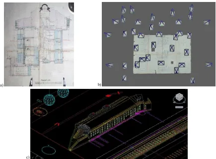
Figure 2. (a) Example of 2D design drawing. (b) Photogrammetric network for the 2D drawing ortho-rectification procedure. (c) Extraction of drawing elements.
2.1 WWI commemoration projects
All around the World, the centenary commemoration of the Great War outbreak has been recognised as key moment, not only to honour who sacrificed their lives in the war, but also to understand the influences of those events on our society, and convey their memories to young generations.
Besides a number of national and local events, ceremonies, and exhibitions, also international organizations have promoted several initiatives. For example, Europeana, the European digital platform for cultural heritage, has sponsored three digital projects:
• the ‘Europeana Collections 1914–1918’ (http://www.europeana-collections-1914-1918.eu/): it is a digital collection of material from national libraries of several countries that were on different sides of the historic conflict.
• the ‘Europeana 1914–1918’
(http://www.europeana1914-1918.eu/en): it is a digital archive of stories, objects, and historical material about the First World War collected and digitized across Europe
• ‘EFG1418’ (http://project.efg1914.eu/): the European Film Gateway is a collection of films and related documents from and related to WWI.
The ‘Wor ld War I Centenar y: Continuations and Beginnings’, funded by the JISC WW1 Open Educational Resources (OER) Programme (http://ww1centenary.oucs.ox.ac.uk/), was a collaboration involving both academic and non-academic experts in different disciplines with the aim of collecting and sharing multi-media contents and providing it through thematic collections that could be used for innovative teaching
approaches and studies, verification of hypothesis and theories, revision of the War itself in its social, cultural, historical and political context. Digital techniques were also employed to virtually simulate the underground warfare using Unity 3D (Lindsay, 2013). Another project designed to share online cultural heritage collection related to the Great War is t he ‘Wor ld War I Memor ial Inventor y Pr oject’ (http://ww1mproject.org/). The website is a searchable database of U.S. WWI memorials, that includes images, history, state of conservation, the names of veterans. 3D models, created employing photogrammetry, are also available in a 3D web viewer based on Sketchfab (https://sketchfab.com/).
As further proof that the Great War represents a milestone in the history of Trentino, it is worth mentioning the ‘Wor ld War I 1914-1918. Tr entino, Italy, Eur ope’ project (http://isig.fbk.eu/projects/world-war-i-1914-1918-trentino-italy-europe). Its main aim was to deepen cultural and social history of the war at different scales, from the Trentino territory up to the broader European context.
3. PROJECT BACKGROUND AND IMPLEMENTATION
away from each other. The main war events, like the war front localization or trenches position, were collected in a geographic information system accessible online (WebGIS), in order to enrich the geography of the territory with historic memory.
3.1 3D surveying and modelling of war scenarios and artefacts
The 3D modelling procedure developed and adopted for the surveying and modelling of the forts and underground passages has been presented in two previous publications (Nocerino et al., 2014; Rodríguez-Gonzálvez et al., 2015). Here, the salient aspects of the developed procedure are summarised in the next sections.
Great efforts have been devoted in the modelling of the Austrian-Hungarian forts disseminated over the Altipiani Cimbr i territory. Indeed, nowadays the majority of the WWI forts in the Trentino region are ruined, both for the damages naturally induced by the war hostilities and also because during the Fascism period, the iron in the military buildings (mainly the beams) was removed to be reused. The most effective and less expensive way to show how the military buildings should have appeared at the outbreak of the Great War is through the adoption of three-dimensional (3D) digital representation techniques.
The integrated methodology for the digital reconstruction of WWI military architectures located on the Trentino plateaus consists of:
• Digitization of historic drawings as base for the modelling workflow;
• Field surveying (aerial and terrestrial photogrammetry, laser scanning, panoramic photography) to record the actual condition of the forts;
• Derivation of missing information (construction materials, shape of coverage) from additional material (historical photos, books, etc.);
• Integration of the produced 3D model into the digital surface model for visualization purposes.
3.1.1 S tudy and digitization of historic documents: A scrupulous literature review was carried out in order to identify the original construction drawings of the Austro-Hungarians fortifications (Figure 2a). The drawings were digitized through the procedure described in detail in Nocerino et al. (2014) and here briefly recalled. For each available historical drawing, a close range photogrammetric survey was realised in order to produce orthoimages of the drawings. A typical photogrammetric network (Figure 2b) acquired with a calibrated SLR camera is processed with a fully automatic orientation, dense image matching and mesh procedure. The orthophoto was finally generated. The accuracy of the proposed methodology for orthophoto production was assessed through comparisons with traditional rectification methods, both analytical and geometrical. The results showed that the adopted photogrammetric-based approach was generally comparable with the classical procedure, with the advantage of being fully automated and independent from the operator precision. However, when the historical drawings displayed big deformation, all rectification methods produced differences greater than the plotting accuracy.
Other historic sources of information were also collected and digitized: antique maps, war front position during the years of conflict, localization of cableways position and trenches. The digitised documents were collected in the WebGIS application (Section 3.3). The digitized construction drawings (Figure 2c) were used as basis for the 3D modelling procedure (Section 3.1.3).
a) b)
Figure 3. (a) UAV photogrammetric survey network on the Verle fort. (b) Laser scanner data (Leica HDS7000) of Vezzena fort.
a) b)
3.1.2 Data acquisition on site: Terrestrial and drone/UAV (Figure 3a) photogrammetric surveys, integrated with terrestrial laser scanning acquisitions (Figure 3b), were conducted to digitally record and then measure the actual situation of the forts on the Altipiani Cimbr i.
The photogrammetric and laser scanning surveys were realized mainly to: (i) obtain reference measurements (for example, height and length of the façades, number and position of the windows), (ii) select the design project plans actually used to build the forts, (iii) verify the correctness of historical designs used in the later stages of modelling, (iv) integrate the missing design data and (v) geo-locate the fortifications. The surveying operations were usually concentrated on external and visible part of the structures as most of the interior/indoor parts are in danger and accesses are normally forbidden.
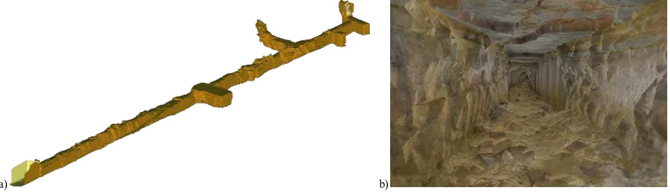
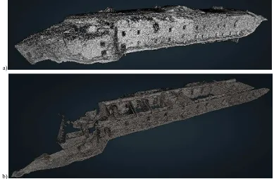
An ad-hoc procedure for surveying and modelling of underground passages, not suitable for classic measuring approached, was also developed and is described in details in a second scientific work also presented at an international conference (Gonzálvez-Rodríguez et al., 2015). Concisely, a dense point cloud of the underground structured was acquired using terrestrial laser scanner - TLS (for the geometry) and images (for colour information). The simplification approach aimed at developing a systematic procedure allowing the
traceability of the whole process and avoiding subjective interpretation in the modelling process. The method, based on free software applications, involved a two-step procedure: (i) a high spatial resolution mesh generated with Poisson algorithm (Kazhdan and Hoppe, 2013) implemented in CloudCompare version 2015 (http://www.cloudcompare.org/) from the input point cloud, and (ii) a successive iterative geometric optimization based on the quadratic edge collapse algorithm (Garland and Heckbert, 1997) implemented in M eshLab (Cignoni et al., 2008). This last step is repeated iteratively: the mesh derived from the previous step is ‘collapsed’ of 5% of total number of triangles until the resulted mesh error against the original input point cloud remained within a user defined threshold. For the VAST project, considering the scale of the original drawings (1:50 up to 1:800), a common drawing error of 0.25 mm, and additional source of errors due to paper deteriorations and digitization error, a final spatial resolution of about 12 cm and a standard deviation of 0.8 cm from the original, full resolution point cloud was considered adequate. Following the described procedure an 87% reduction of the triangles, preserving significant geometric information, was obtained for the 110 m long underground tunnel, part of the Luser na military fortification (Figure 4).
Figure 5. Modelling of forts and example of the produced 3D models inserted into their digital environment.
a) b)
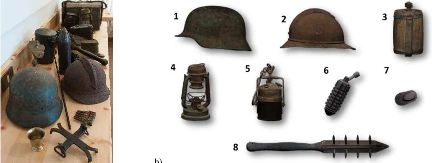
Figure 6. (a) T he WWI findings. (b) 3D models of war findings: 1) Austro-Hungarian helmet, 2) Italian helmet, 3) Water bottle, 4) Ditmar lamp, 5) Osmeka DB lamp, 6) Hand grenade, 7) Reinforced glasses, 8) Spiked club. All models are freely accessible on the web in the Europeana
3.1.3 3D models of forts: The original design drawings (plants, original digitized sections and / or tables), digitized according to the procedure described in section 3.1.1, were used as basis for the 3D modelling procedure. Classic CAAD (computer aided architectural design) modelling tools (e.g. extrusion, Boolean operations of solids) have been applied to produce digital models of the forts. Geometrical information extracted from longitudinal and cross sections, elevations, have been employed to extrude the original height and position of the different floors. Similarly, 3D solids of domes and roofs were created from 2D polylines and curves, derived from the available design drawings. 3D models representing the geometry of the buildings were then enriched with a texture mapping process: virtual textures were created on the basis of information from existing forts of the same period that have been already restored and historical images (Figure 5).
3.1.4 3D modelling of war findings: On the plateaus of Luser na, Folgar ia Lavar one several items used by the Austrian and Italian troops during the Great War have been found. These artefacts are now preserved and displayed at the Centr o Documentazione museum in Luser na, and were digitized with 3D fringe projection scanning and photogrammetric t echniques (Figure 6).
3.1.5 S haring the 3D models: The realised 3D models of both forts and war findings have been shared both on the Europeana portal (http://www.europeana.eu/portal/en) within the ‘3D Icons project (http://3dicons-project.eu/) funded by the European Union and on the 3DOM 3D models repository (http://3dom.fbk.eu/repository/portal/portal.html). Each model is interactively visible in a javascript-base web viewer (https://code.google.com/archive/p/jsc3d/) embedded in a dedicated web page (Figure 7), where all the relevant information (metadata, description of the surveying and modelling technique) are shown.
3.2 Virtual tour of the war territory
With the same perspective of enhancing the cultural value of the symbols of the Great War by increasing their visibility and accessibility, a virtual tour consisting in immersive panoramic images showing the Altipiani landscape, as well as the actual
situation of the forts and military structures, was realised and
made available on line
(http://3dom.fbk.eu/repository/files/vast/vt/tour.html).
Figure 7. Example of web page displaying the 3D model of a war finding (http://3dom.fbk.eu/repository/files/vast/spiked_club/
spiked_club_3D.html).
3.3 WebGIS
In order to make available all the “geographic” data collected, heterogeneous both for type and "provenance" (publications, measurements on site, etc.), a geographic information system accessible online (WebGIS, http://vast-gis.fbk.eu/) was realized. The base of the WebGis is a database, consisting of tables where the different available data were collected and organized. For example, the table related to the forts contains various information such as theirs names, construction details, or the type of armament.
The web interface allows the user to view the information of interest (for example, location of the border at the beginning of the conflict) due to implemented functions (query) that "interrogate" the database to extract the required data and display it.
a) b)
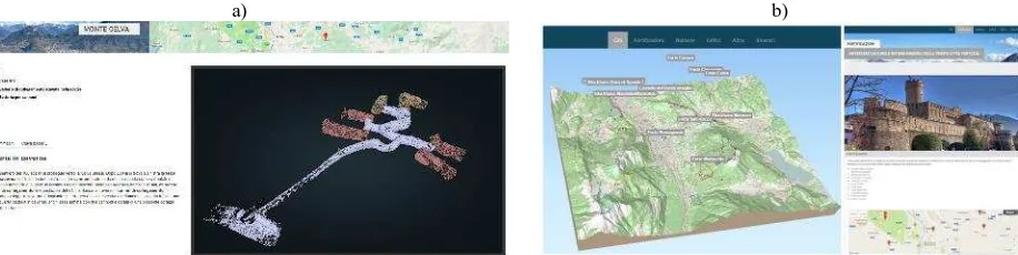
Figure 8. (a) T he web page on the Austro-Hungarian fortifications and underground tunnels on Mount Celva (Trento, Italy, http://3dom.fbk.eu/repository/3Dpointclouds/celva/index.html). (b) The WebGIS of the ‘Trento Citta’ Fortezza’ project
4. FOLLOW-UP OF THE PROJECT
The VAST project had various follow-up activities based on its products and achievements.
4.1 The Trento Citta’ Fortezza project
The Trento Citta’ Fortezza (Trento City Fortress,
http://trentocittafortezza.fbk.eu/home) project was started in t he beginning of 2016 in cooperation with a high school (Istituto Buonar r oti - Pozzo, http://www.ittpozzo.it/) in Trento. T he aim of the project was to actively involve young students in the creation of cartographic and multimedia products related to the city of Trento during the WWI. The city was fortified by the Austro-Hungarian army at the beginning of 1900 to defend its territory from any Italian military assault. The main objectives of the projects were to:
• collect heterogeneous data regarding the Fortress of Trento in the WWI;
• survey and model the Austro-Hungarian military structures in the area of Trento, included the fortifications on M onte Celva (Figure 8a, http://3dom.fbk.eu/repository/3Dpointclouds/celva/in dex.html);
• realize end-products such as paper maps, WebGIS (Figure 8b, http://3dom.fbk.eu/repository/files/ITT/ gistcf.html) and Apps for mobile devices.
4.2 3D survey for restoration purposes of Sommo Alto fort
In June 2016, the public administration of the municipality of Folgaria (Trento) engaged the FBK-3DOM group, that led the scientific and technological activities of the VAST project, to survey and model the Sommo Alto fortification. The commitment consisted in producing 2D sections and plans of the Sommo Alto fort for planning the restoration of the internal structures of the military building. 2D drawings at 1:50 scale were extracted from a very dense point cloud of the fortification (Figure 9), acquired using an innovative hand-held mobile indoor 3D mapping system (http://geoslam.com/). The final
segmented 3D point cloud of the fort is accessible on-line (http://3dom.fbk.eu/repository/3Dpointclouds/index.html#fortes ommoalto).
5. CONCLUS IONS
The VAST project has provided a timeless rebirth to the memory of the Great War in the area of Trento. 3D digital models of the original appearance of military fortresses were realized, based on historic evidences (maps and photos) and measurements acquired on site. Analogously, military objects found on the plateaus and now stored in t he museums were digitized. All 3D models are made available on the web, to allow their access also with smart devices directly on site. Immersive virtual tours, communication material and WebGIS were realized too. The first, based on panoramic images, allow to travel and visit the war space (“warscape”), understand connections and links in a virtual and unique way. Communication material, based on 3D reconstructed scenarios and objects, allow to disseminate cultural information and reach also young generations. The WebGIS displays the main war events and localizations such as fortification and trenches, positions, in order to enrich the geography of the territory with historic memory.
The WWI places and items have been enriched and empowered with new meaning thanks to the exploitation of 3D digital technologies. The possibility to access 3D digital models almost everywhere, even on trekking paths on high peaks, allows also non experts in understanding better and deeper the history and culture of the territory . And this is even truer when it comes to the Austro-Hungarian forts now in ruins. Thanks to the VAST project, young generations can now “see” and, then, really understand what their complex and impressive structure should have been. Scientists and researchers can verify their own hypothesis and theories, make comparisons with buildings or war objects of other historic periods or present in other geographic and cultural areas.
The results of the VAST project are expected to promote touristic and cultural richness of the Altipiani Cimbr i, mainly
a)
b)
through their on-line (web) and on-site (thanks to wireless network communication) accessibility.
The 3D digital models may be included in further products, like augmented or virtual reality (AR/VR) applications, serious games for education and awareness-raising, etc.
ACKNOWLEDGEMENTS
The VAST project was partially funded by Fondazione Cassa di Risparmio di Trento e Rovereto – CARITRO. The authors are really thankful to all partners (Centr o Documentazione Luser na, Istituto Cimbr o Luser na, Centr o Inter nazionale Studi di Ar cheologia di Super ficie, Fondazione For te Belveder e) involved in the VAST project, as well as Ar chivio Stor ico di Tr ento and the Azienda per il Tur ismo Folgar ia, Lavar one e Luser na for their fundamental contribution and valuable support in the bibliographic and historical research.
M any thanks to students and professors of the Istituto Buonar r oti - Pozzo in Trento for their cooperation in the Tr ento Citta’ Fortezza project (http://trentocittafortezza.fbk.eu/home). The authors are also grateful to: (i) Dr. Nadia Guardini (M e.s.a. srl, http://www.mesa-laserscanner3d.com/) for providing the ZEB1 used for the survey of Sommo Alto; (ii) Dr. Dirk
Rieke-Zapp (AICON 3D Systems GmbH,
http://aicon3d.com/start.html) for providing the SmartScan AICON scanner employed for the digitization of war findings;
(iii) SAL engineering
(http://www.salengineering.it/public/en/1/index.asp) for their support with the UAV acquisition of Ver le and Cher le forts.
REFERENCES
Cacciaguerra, G., Gatti, M . P., 2010. The modernity exhibited by the building technologies adopted for nineteenth century Trentine fortresses. Proc. IAHS World Congress on Housing 2010, Santander, pp. 1-9.
Cignoni, P., Callieri, M ., Corsini, M ., Dellepiane, M ., Ganovelli, F. and Ranzuglia, G., 2008. M eshlab: an open-source mesh processing tool. In Eurographics Italian Chapter Conference. Vol. 2008, pp. 129-136.
Coluzzi, P., 2004. Symbolic acquisition planning? The case of Cimbrian in Italy. III Mercator Symposium 2004: “Linguistic diver sity and education: challenges and oppor tunities". http://www.cimbri.org/download/coluzzi2004.pdf, p. 13.
Denker, A.., 2016. Virtual Palmyra: 3D reconstruction of the lost reality of “the bride of the desert”. In Proceedings of the Arqueológica 2.0-8th International Congress on Archaeology, Computer Graphics, Cultural Heritage and Innovation: Universitat Politècnica de València, pp. 318-320.
Georgopoulos, A., 2014. 3D virtual reconstruction of archaeological monuments. Mediter r anean Ar chaeology and Ar chaeometr y, 14(4), pp.155-164.
Garland, M . and Heckbert, P.S., 1997. Surface simplification using quadric error metrics. In Proceedings of the 24th annual conference on Computer grap hics and interactive techniques. ACM Press/Addison-Wesley Publishing Co, pp. 209-216.
Guidi, G., Russo, M . and Angheleddu, D., 2013. Digital Reconstruction of an Archaeological Site Based on the Integration of 3d Data and Historical Sources.
ISPRS-Inter national Ar chives of the Photogr ammetr y, Remote Sensing and Spatial Infor mation Sciences, 1(1), pp.99-105.
Guidi, G., Russo, M ., Ercoli, S., Remondino, F., Rizzi, A. and M enna, F., 2009. A multi-resolution methodology for the 3D modeling of large and complex archeological areas. Inter national Jour nal of Ar chitectur al Computing, 7(1), pp.39-55.
Hanke, K., M oser, M . and Rampold, R., 2015. Historic photos and TLS data fusion for the 3D reconstruction of a monastery altar ensemble. The Inter national Ar chives of Photogr ammetr y, Remote Sensing and Spatial Infor mation Sciences, 40(5), p.201.
Kazhdan, M . and Hoppe, H., 2013. Screened Poisson surface reconstruction. ACM Transactions on Graphics (TOG), 32(3), p.29.
Kinji, O., Andaroodi, E., Einifar, A. and M atini, M ., 2008. 3DCG reconstitution and virtual reality of UNESCO world heritage in danger. The Citadel Of Bam. Pr ogr ess In Infor matic, pp 99-136
Lindsay. K., 2013. World War I Centenary: Continuations and Beginnings. Final Report. Academic IT Ser vices, Univer sity of Oxfor d. http://repository.jisc.ac.uk/5121/1/WW1C-FinalReport.pdf
Nocerino, E., Fiorillo, F., M into, S., M enna, F. and Remondino, F., 2014. A non-conventional procedure for the 3D modeling of WWI forts. The Inter national Ar chives of Photogr ammetr y, underground passages in WWI fortifications. The Inter national Ar chives of Photogr ammetr y, Remote Sensing and Spatial Infor mation Sciences, Vol. XL-5/W4, pp. 17-24.
Torres-M artínez, J.A., Seddaiu, M ., Rodríguez-Gonzálvez, P., Hernández-López, D. and González-Aguilera, D., 2015. A M ulti-Data Source and M ulti-Sensor Approach for the 3d Reconstruction and Visualization of a Complex Archaelogical Site: the Case Study of Tolmo de M inateda. Remote Sensing, 8(7), 550, pp. 1-25